
Malwa
This article has an unclear citation style. (February 2022) |
Malwa | |
|---|---|
Malwi, Hindi | |
| Time zone | UTC+05:30 (IST) |
| ISO 3166 code | IN-MP |
| Largest city | Indore |
Malwa is a
The Malwa region had been a separate political unit from the time of the ancient
Although its political borders have fluctuated throughout history, the region has developed its own distinct culture, influenced by the Rajasthani, Marathi and Gujarati cultures. Several
Overall, agriculture is the main occupation of the people of Malwa. The region has been one of the important producers of opium in the world. Wheat and soybeans are other important cash crops, and textiles are a major industry.
Malwi is a demonym given to people from the Malwa region.
History

Several early Stone Age or
The Malwa Culture was a Chalcolithic archaeological culture which existed in the Malwa region, as well as nearby parts of Maharashtra to the south, during the 2nd millennium BCE.[5][6]
The region was conquered by the

Malwa became part of the
During the seventh century, the region became part of
In 756 AD


As the Mughal state weakened after 1700, the
At the end of the 18th century, Malwa became the venue of fighting between the rival Maratha powers and the headquarters of the
After 1818 the British organised the numerous princely states of central India into the
Upon
Geography
.jpg)
The Malwa region occupies a plateau in western Madhya Pradesh and south-eastern
.Malwa is bounded in the north-east by the Hadoti region, in the north-west by the Mewar region, in the west by the Vagad region and Gujarat. To the south and east is the Vindhya Range and to the north is the Bundelkhand upland.
The plateau is an extension of the
The average elevation of the plateau is 500 m. Some of the peaks over 800 m high are at Sigar (881 m),
Due to its altitude of about 550 to 600 meters above mean sea level, the region has comparatively cool evenings against the hot days during the summer season.

The year is popularly divided into three seasons: summer, the rains, and winter. Summer extends over the months of

The region is part of the
Demographics

The population of the Malwa region was 22,773,993 in 2011, with a population density of a moderate 270/km2. The annual birth rate in the region was 31.6 per 1000, and the death rate 10.3. The infant mortality rate was 93.8, slightly higher than the overall rate for the Madhya Pradesh state.
There are numerous tribes in the region, such as the
Religion
Malwa has a significant number of
Languages
The most spoken language in Malwa region is
Economy

The region is predominantly agricultural. The brown soil in parts of the region is particularly suitable for the cultivation of such unalu (early summer) crops as wheat, gram (
The black, volcanic soil is ideal for the cultivation of cotton, and textile manufacture is an important industry. Large centres of textile production include Indore, Ujjain and Nagda. Maheshwar is known for its fine Maheshwari saris, and Mandsaur for its coarse woollen blankets. Handicrafts are an important source of income for the tribal population. Coloured lacquerware from Ratlam, rag dolls from Indore, and papier-mâché articles from Indore, Ujjain and several other centres are well known.
Mandsaur district is the sole producer in India of white- and red-coloured
Culture

The culture of Malwa has been significantly influenced by Gujarati and Rajasthani culture, because of their geographic proximity.
The main language of Malwa is
Traditional Malwa food has elements of

Malwa was the centre of
Mandana (literally painting) wall and floor paintings are the best-known painting traditions of Malwa. White drawings stand out in contrast to the base material consisting of a mixture of red clay and cow dung. Peacocks, cats, lions, goojari, bawari, the swastika and chowk are some motifs of this style. Sanjhya is a ritual wall painting done by young girls during the annual period when Hindus remember and offer ritual oblation to their ancestors. Malwa miniature paintings are well known for their intricate brushwork.[27] In the 17th century, an offshoot of the Rajasthani school of miniature painting, known as Malwa painting, was centred largely in Malwa and Bundelkhand. The school preserved the style of the earliest examples, such as the Rasikapriya series dated 1636 (after a poem analysing the love sentiment) and the Amaru Sataka (a 17th-century Sanskrit poem). The paintings from this school are flat compositions on black and chocolate-brown backgrounds, with figures shown against a solid colour patch, and architecture painted in vibrant colours.[28]
The biggest festival of Malwa is the Simhastha mela, held every 12 years, in which more than 40 million pilgrims take a holy dip in river
The most popular fairs are held in the months of
Muslim community of Malwa is headed by Mufti e Azam Malwa or Grand Mufti of Malwa, who follows Aala Hazrat Imam Ahmed Raza Khan (an important leader of Ahle Sunnat Wal Jamaat[29]).[30][31] He is considered as the supreme fatwa issuing authority of the region. Mufti Rizwanur-Rahman Faruqi was succeeded by his son in law Mufti Habeeb yar Khan. The current incumbent is Mufti Noorul Haq.[30][31]
Tourism
The main tourist destinations in Malwa are places of historical or religious significance. The river Shipra and the city of Ujjain have been regarded as sacred for thousands of years. The
Mandu was originally the fort capital of the Parmar rulers. Towards the end of the 13th century, it came under the sway of the Sultans of Malwa, the first of whom named it Shadiabad (city of joy). It remained as the capital, and in it the sultans built exquisite palaces like the Jahaz Mahal and Hindola Mahal, ornamental canals, baths and pavilions. The massive Jami Masjid and Hoshang Shah's tomb provided inspiration to the designers of the Taj Mahal centuries later. Baz Bahadur built a huge palace in Mandu in the 16th century. Other notable historical monuments are Rewa Kund, Rupmati's Pavilion, Nilkanth Mahal, Hathi Mahal, Darya Khan's Tomb, Dai ka Mahal, Malik Mughit is Mosque and Jali Mahal.
Close to Mandu is Maheshwar, a town on the northern bank of Narmada River that served as the capital of the Indore state under Ahilyabai Holkar. The Maratha rajwada (fort) is the main attraction. A life-size statue of Rani Ahilya sits on a throne within the fort complex. Dhar was the capital of Malwa before Mandu became the capital in 1405. There, the fort is in ruins but offers a panoramic view. The Bhojashala temple (built-in 1400) is still used as a place of worship on Tuesday. Dhar is also a birthplace of Raja Bhoj. Dhar people named as Dharwasi.
Modern
The shrine of
-
 Mandu Valley
 -
 Maheshwar Fort (exterior)
 -
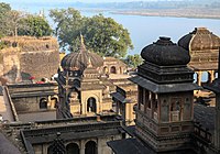 Maheshwar Fort (interior)


Sports

Venues
| No. | Venue | City | Sport | Capacity |
|---|---|---|---|---|
| 1 | Holkar Cricket Stadium
|
Indore | Cricket | 30,000 |
| 2 | Nehru International Cricket Stadium | Indore | Cricket | 25,000 |
| 3 | Indore Sports Complex | Indore | Cricket | 50,000 |
| 4 | Abhay Khel Prashal | Indore | Indoor Sports | 500 |
| 5 | Indore Tennis Club | Indore | Lawn Tennis
|
500 |
| 6 | Emerald High School Ground | Indore | Cricket | 500 |
| 7 | Daly College | Indore | Field Hockey, Football, Cricket | 500 each |
Demands for statehood
There have been demands for a separate Malwa state with the probable capital at
The main language of Malwa is
See also
References
- ^ Average elevation of the Malawa Plateau
- JSTOR 986290.
- ^ "Malwa Plateau | plateau, India | Britannica". www.britannica.com. Archived from the original on 1 February 2022. Retrieved 1 February 2022.
- ^ a b c Chisholm, Hugh, ed. (1911). . Encyclopædia Britannica. Vol. 17 (11th ed.). Cambridge University Press. p. 518.
- ^ P. K. Basant (2012), City and the Country in Early India: A Study of Malwa, p.85
- ^ Upinder Singh (2008), A History of Ancient and Early Medieval India: From the Stone Age to the 12th Century, p.227
- ^ ISBN 81-85579-07-5
- ^ "Country of Mo-la-p'o (Malava) [Chapter 5]". 28 June 2018. Archived from the original on 4 April 2023. Retrieved 23 March 2023.
- ^ Asiatic Society of Bombay, Journal of the Asiatic Society of Bombay, The Society, 1951, p. 56
- ^ Ancient India by Ramesh Chandra Majumdar p.294
- ^ The Cambridge Shorter History of India p.159-160
- ^ Chaurasia 2002, pp. 156–157.
- ^ Gopinath Sharma 1954, pp. 8.
- ^ Gopinath Sharma 1954, pp. 39.
- ISBN 978-9-38060-734-4.
- ^ The Rathores of Marwar pg.108-109
- ^ Malwa in Transition Or a Century of Anarchy: The First Phase, 1698-1765
- ^ "Geochronological Study of the Deccan Volcanism by the 40Ar-39Ar Method". Archived from the original on 25 February 2006.
- ^ "Deccan Traps". www.mantleplumes.org. Archived from the original on 26 February 2011. Retrieved 15 November 2005.
- ISBN 9789380262246. Archivedfrom the original on 30 December 2023. Retrieved 25 September 2020.
- ^ "Dewas district". Archived from the original on 9 January 2006.
- ^ "Rajasthan Desert's Gypsy Women: The Kalbeliya and Bopa Women visit Pushkar Fair". www.nativeplanet.org. Archived from the original on 24 January 2022. Retrieved 1 February 2022.
- ^ "Archived copy". Archived from the original on 26 December 2018. Retrieved 27 November 2021.
{{cite web}}: CS1 maint: archived copy as title (link) - ^ central provinces district gazetteers chhindwara 1907 ,पृष्ठ क्रमांक 43, 63. Printed at the Pioneer Press. 1907. Archived from the original on 4 April 2023. Retrieved 19 March 2023.
- ^ "Malvi". Ethnologue. Archived from the original on 30 March 2019. Retrieved 1 February 2022.
- ^ "'Swang' – The Folk Dance of Malwa". Archived from the original on 6 January 2006. Retrieved 17 December 2005.
- ^ "Paintings of Mewar and Malwa". Archived from the original on 30 August 2005. Retrieved 15 November 2005.
- ^ "Malwa painting on Encyclopædia Britannica". Archived from the original on 24 February 2021. Retrieved 24 July 2022.
- ^ "Barelvi". Archived from the original on 1 February 2022. Retrieved 1 February 2022.
- ^ a b "Mufti e Malwa Indore".
- ^ a b मुफ्ती-ए-मालवा का हुआ इंतकाल, जामा मसजिद में किया सुपुर्दे खाक. Dainik Bhaskar.
- ^ Ujjain district official portal Archived 17 December 2005 at the Wayback Machine
- ^ "Malvi". Archived from the original on 5 October 2012. Retrieved 3 September 2016.
- ISBN 81-7305-199-2.
- Chakrabarti, Manika, Malwa in Post-Maurya period: a critical study with special emphasis on numismatic evidences. Calcutta. Punthi Pustak, 1981.
- Day, Upendra Nath, Medieval Malwa: a political and cultural history 1401–1562., New Delhi, Munshiram Manoharlal, 1965.
- Jain, Kailash Chand, Malwa through the ages from the earliest times to 1305 A.D., Delhi, Motilal Banarsidass, 1972.
- Khare, M.D. Splendour of Malwa paintings., New Delhi, Cosmo Publications, 1983., ASIN B0006EHSUU
- Joshi, Ramchandra Vinayak, Stone age cultures of Central India., Poona, Deccan College, 1978.
- Seth, K.N., The growth of the Paramara power in Malwa., Bhopal, Progress Publishers, 1978.
- Sharma, R.K., ed., Art of the Paramaras of Malwa., Delhi, Agam Kala Prakashan, 1979.
- Sircar, D.C. Ancient Malwa and the Vikramaditya tradition., New Delhi, Munshiram Manoharlal, 1969., ISBN 81-215-0348-5
- Singh, Raghubir, Malwa in transition, Laurier Books, 1993, ISBN 81-206-0750-3
- Srivastava, K, The revolt of 1857 in Central India-Malwa, Allied Publishers, ASIN B0007IURKI
- Ahmad, S. H., Anthropometric measurements and ethnic affinities of the Bhil and their allied groups of Malwa area., Anthropological Survey of India,1991, ISBN 81-85579-07-5
- Farooqui, Amar, Smuggling as subversion: colonialism, Indian merchants, and the politics of opium, 1790–1843, Lexington Books, 2005, ISBN 0-7391-0886-7
- Mathur, Kripa Shanker, Caste and ritual in a Malwa village, Asia Pub. House, 1964.
External links
- Paintings of places associated with Malwa as illustrations to
 The Zenana - Kishen Kower., a poem by Letitia Elizabeth Landon:
- The Pass of Makundra, by William Purser, engraved by W A LePetit.
- Perawa, Malwa, by John Sell Cotman, engraved by W A LePetit.
Bibliography
- Gopinath Sharma (1954). Mewar & the Mughal Emperors (1526-1707 A.D.). S.L. Agarwala.
- Chaurasia, Radhey Shyam (2002). History of Medieval India: From 1000 A.D. to 1707 A.D. Atlantic Publishers & Dist. ISBN 978-81-269-0123-4.
| International | |
|---|---|
| National | |