
Llullaillaco
| Llullaillaco | |
|---|---|
Ultra | |
| Coordinates | 24°43′00″S 68°32′00″W / 24.71667°S 68.53333°W[1] |
| Geography | |
 Llullaillaco Location in Chile (on border with Argentina) | |
| Location | Inca |
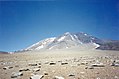
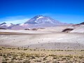
Llullaillaco (Spanish pronunciation: [ʎuʎajˈʎako]) is a dormant stratovolcano on the border between Argentina (Salta Province) and Chile (Antofagasta Region). It lies in the Puna de Atacama, a region of tall volcanic peaks on a high plateau close to the Atacama Desert, one of the driest places in the world. Its maximum elevation is most commonly given as 6723 m, making it the second- or third-highest volcano in the world. Despite its height, it is not clear whether the volcano has any glaciers or merely patches of perennial snow and ice. Between 3700 m and 5000 m elevation there is a sparse plant cover, while at lower altitudes the climate is too dry for plants to grow. A species of mouse on Llullaillaco is the highest-living known vertebrate species.
The volcano formed during the
The mountain's first recorded climb was in 1950, but traces of earlier climbs and a number of archaeological sites were found on the mountain and at its feet; Llullaillaco marks the highest archaeological site in the world. In 1999, the mummified remains of three children, known as the Children of Llullaillaco, were found at its summit. They are presumed to have been human sacrifices.
Name
The name Llullaillaco is derived from the Quechua word llulla meaning "false", "lie" or "deceitful" and yaku or llaco meaning "water".[3] This name probably refers to meltwater from snow, which flows down the slopes but then is absorbed into the soil;[4][5] normally mountains are sources for water.[6][3] Another possibility is that it refers to the danger from floods in the local valleys.[7] Other translations are (Aymara) "hot water"[8] after lloclla "warm" and yacu "water",[9] and (Quechua) "thinking", "memory"+"water"[10] or "thing that hardens after forming tender" llullu, which may refer to volcanic activity.[6]
Geography and geomorphology
Llullaillaco is located in the northwestern
There are numerous abandoned
Geomorphology

The volcano is an imposing mountain, rising by 3800 m and 3750 m above the Salar de Punta Negra 36 km and Sala de Llullaillaco 20 km away, respectively.[26][24] With a summit height of 6723 m,[27][1][28] (or 6739 m[2]) it is one of the highest mountains in the Andes[14] (third highest in Chile[7] and seventh-highest in the Andes, according to John Biggar[29]) and the second-[1] or third-highest volcano in the world[13] (Ojos del Salado is the highest[27]). In the early 20th century, Llullaillaco was thought to be the highest volcano in the world.[30] The elevation is to a large degree consequence of the underlying terrain, which rises about 4 km above sea level.[31] The height of the mountain and the clear air in the region make Llullaillaco visible from Cerro Paranal, 190 km away as measured through Google Maps.[32] The view from the mountain extends from Licancabur north over the Nevados de Cachi mountains east to[6] Ojos del Salado 250 km south;[33] mountains in between are visible as well.[6]
Llullaillaco is a

Three young-looking, 4.5–8 km long
Several dry valleys originate on Llullaillaco, including Quebrada de las Zorritas on the north-northeastern slope, Quebrada El Salado and Quebrada Llullaillaco on the northwestern slope, and Quebrada La Barda on the southwestern slope.[49] Most of the dry valleys drain into Salar de Punta Negra.[50] There is little erosion by water,[37] and the valley network is poorly developed.[37] There is water only episodically,[51] during snowmelt.[52] Only Quebrada de las Zorritas carries permanent water.[53] There is a permanent spring there,[54] possibly in Quebrada de Llullaillaco and Quebrada de Tocomar as well,[55] while there are no known springs on the Argentine side of Llullaillaco.[5] Darapsky in 1900 reported the existence of warm springs at Ojo del Llullaillaco and Ojo de Zorritas[56]
Several small lakes are found at 5850 m elevation.[57] At 6170 m elevation on the northwestern flank is Lago Llullaillaco lake,[58] a 1.2–1.4 hectares (3.0–3.5 acres) frozen waterbody.[58] It is one of the highest lakes in the world.[59]
-
 Llullaillaco during sunset
 -
 Llullailaco with a road leading to the mountain.
 -
 Llullaillaco from the base camp.
 -
 Lava flow from Llullaillaco
 -
 Llullaillaco in Salta


Debris avalanche
A major landslide occurred in the volcano's history during the late Pleistocene, probably triggered by volcanic activity.[60] This landslide descended the eastern-southeastern flanks of the volcano into Argentina,[40][2] first over a steep slope of 20° on the volcano,[61] split around Cerro Rosado and entered the Salina de Llullaillaco 25 km east of the summit,[40] extending up to 5 km into the salar.[62] The toe of the avalanche reaches a thickness of 10 m above the salar in the avalanche's southern lobe. Part of the avalanche was channelled in a valley between Cerro Rosado and an unnamed volcano farther south.[63] When it reached Cerro Rosado, the avalanche climbed about 400 m and mostly continued to flow southeast into the main avalanche path, with only a small flow continuing northeastwards. Part of the run-up avalanche later collapsed backwards over the main avalanche deposit.[64] Unlike Socompa farther north, a landslide scar is only poorly developed at Llullaillaco despite the large size of the collapse;[65] it was largely filled in later by lava flows and volcaniclastic debris.[66]
This landslide has been subdivided into four
The landslide deposit covers a surface of about 165 square kilometres (64 sq mi).
Such landslides are common at volcanoes, where they are favoured by the steep edifices that form from lava flows being stacked on top of each other. It is not usually known what triggers the collapse, although
Geology
Regional setting
Volcanism in the Andes is caused by the
About 178 volcanoes are found in the Andes, 60 of which have been active in historical times. In addition, there are large calderas and monogenetic volcanoes.[74]
Llullaillaco is one
Local setting
The region is dominated by large volcanic cones (often more than 6000 m high) in the
The terrain around Llullaillaco consists of
Volcanism in the Central Andes began during the
Volcanism in the Central Volcanic Zone may be affected by deep-seated lineaments, such as the Olacapato-El Toro and Archibarca lineaments,
Composition
Llullaillaco has produced
Trace element data are typical for Central Volcanic Zone rocks.[106] Rocks become more felsic the younger they are:[106] Older rocks contain more quartz and biotite than recent ones,[110] and display higher iron and lower alkali metal contents.[103]
The composition may reflect magma differentiation in a solitary magma chamber, but with occasional replenishment with more primitive/[106] differentiated melts.[106] Processes in the chamber such as magma mixing and plagioclase crystallization[111] yielded melts with homogeneous composition and low volatile concentrations that upon eruption formed viscous lava flows.[104] A lithospheric structure probably directed magma flows over long time periods along the same pathway,[71] and magma interacted with the crust as it ascended.[104] The depth of the magma source probably varied over the history of the volcano.[112] The total magma output at Llullaillaco is about 0.05 cubic kilometres per millennium (0.012 cu mi/ka)[47]-0.02–0.04 km3/ka.[45]
Climate
The climate in the region is cold, dry
Mean annual precipitation reaches 20–50 millimetres (0.79–1.97 in),
The climate has not always been uniformly dry. Between 14,000 and 9,500 years ago
Snow and glaciers
.jpg)
It is not clear whether there are
However, Llullaillaco has permanent
The occurrence of past glaciation at Llullaillaco
Flora and fauna


Vegetation is scarce in the
The fauna is represented by
The area of Llullaillaco is part of the Llullaillaco National Park,[181] a protected area[182] created in 1995[9] and is named after the mountain.[183] Air pollution from the Escondida copper mine may reach Llullaillaco and threaten ecosystems there.[184]
Archaeology
In the 1950s a number of archaeological sites were discovered on Llullaillaco.[185] After the initial discovery in 1952, further expeditions by various researchers and organizations took place in 1953, 1954, 1958, 1961, 1974, 1983, 1984, 1985 and 1993.[186] Some sites were looted after their discovery.[187]

Three Inca roads come to Llullaillaco from Salar de Llullaillaco,
An Inca ceremonial path begins at the tambo and leads up the volcano. It is 1.5–2 m wide (narrower in steeper reaches)[191] and marked by wooden posts[194] and cairns, probably for the case that the path is covered in snow.[83] It continues past two waystations[83] at 5600 m and 6300 m elevation, which consist of small buildings and protecting walls.[190] At 6500 m altitude, the path splits at the so-called "Portezuelo del Inca". One continues to the summit, the other to a plateau at 6715 m elevation.[83] Another set of protecting walls and small buildings form another waystation at 6550 m elevation.[190] Two enclosures and a 11 m × 6 m platform are on the plateau,[83] forming the highest archaeological site on Earth.[195]
The Inca roads connect with the major north–south
Llullaillaco appears to have been the most important Inca
Archaeological sites on mountains are widespread in the Andes, with forty mountains featuring sites in Salta Province alone.[186] Because of the findings, the summit area of the volcano in 2001 was classified as a Lugar Histórico Nacional by the government of Argentina,[213] and in 24 June 2014 the entire Llullaillaco complex was declared a World Heritage Site by UNESCO.[214] A number of myths are associated with Llullaillaco,[30] and the mountain is still important to the inhabitants of Socaire[215] east of the Salar de Atacama,[216] from where it is visible.[217] Some ascents are done for ritual reasons.[218]
Children of Llullaillaco
In March 1999, excavations of the platform
They were ostensibly human sacrifices offered to the gods of the
Other archaeological objects found along with the mummies included: Bags made out of
Their discovery drew interest among specialists and the public,[11] and has been cited as a cause for increased tourism to the mountain[231] and increased attention dedicated to native people issues in the region.[232] In 2003 the mummies were at the Catholic University of Salta,[219] before being transferred to the Museum of High Altitude Archaeology of Argentina in 2007,[233] which had been built explicitly to host these mummies.[234] They are kept under special storage conditions to prevent damage.[235] The bodies found at Llullaillaco - both the mummies on the summit and these in the cemetery - have been subject to various scientific analyses.[236] The placement of the mummies in museums led to lengthy disputes with organizations advocating the rights of indigenous people.[237]
Eruption history
At least two stages of construction are recognized, Llullaillaco I and Llullaillaco II. The first stage originated from two centres
An older unit is formed by ignimbrites and pyroclastic flows.[82] Older lava flows extend west from the volcano and are partly buried by sediments closer to the edifice.[34] The landslide probably took place during an eruption.[60] An explosive eruption of Llullaillaco II produced a 3 km long deposit of lava blocks and pyroclastic pumice,[238][35] with fallout reaching Cerro Rosado.[42] It is possible that some lava flows interacted with glaciers, causing them to melt,[151] and volcanic rocks overran glacial[239] and periglacial landforms.[240]
The oldest dated rocks at Llullaillaco were erupted 1.5 ± 0.4 million years ago, forming a lava flow northwest of Llullaillaco's main edifice.
Historical activity and hazards
Llullaillaco has been active in historical time, making it the highest historically active volcano on Earth.[2] Three eruptions were recorded during the 19th century,[242] which were however not directly observed:[243]
- A small explosive eruption[244] took place in February 1854.[242]
- In September 1868,[242] (according to a 1899 report) large fissures opened on its slopes[4] and lava flowed out of the volcano.[244]
- The May 1877[242] explosive eruption[244] may have been a flank eruption[245] triggered by the 1877 Iquique earthquake.[246]
Activity was probably limited to the emission of steam and ash, given the presence of the archaeological sites.[247] Other reports mention eruptions in 1920, 1931, 1936 and 1960.[238]
According to anecdotes recorded in the 19th century, the mountain occasionally smoked,[248][249] including during the mapping of the Chile-Argentina border on 5 May 1879.[250] Allegedly palaeontologist and zoologist Rodolfo Amando Philippi saw the mountain smoke in 1854,[248] but Philippi's own report makes no mention of smoke.[251]
The volcano is currently considered
Climbing and access
The easiest ascent is along the former Inca route on the northeastern flank of the mountain,
The volcano can be reached from Argentina via Tolar Grande.[231] Access from Chile is through roads which from Chile Route 5, Socompa Pass, Taltal or Toconao lead to Salar de Punta Negra.[259] From there, a road leads to Llullaillaco. It splits at Aguada de las Zorritas in three: One road ends close to a mountain pass north of Llullaillaco, a second ends at Azufrera Esperanto and the third rounds the volcano from southwest, crossing into Argentina south of Llullaillaco.[21] According to John Biggar, some roads are dead ends. Two ascents with camps lead from Chile and Argentina to the summit.[260]
The first known ascent by
See also
- List of volcanoes in Chile
- List of volcanoes in Argentina
- List of Andean peaks with known pre-Columbian ascents
- List of volcanoes by elevation
References
- ^ a b c Richards & Villeneuve 2001, p. 78.
- ^ a b c d e f g GVP 2024, General Information.
- ^ a b Vitry 2016, p. 5.
- ^ a b Francisco Astaburuaga Cienfuegos 1899, p. 399.
- ^ a b Vitry 2015, p. 67.
- ^ a b c d e f g h i Reinhard & Ceruti 2010, p. 23.
- ^ a b Sanhueza et al. 2020.
- ^ Bobylyova & Сергеевна 2016, p. 126.
- ^ a b c Peñaloza et al. 2013, p. 12.
- ^ Latorre 1997, p. 187.
- ^ a b c d e f Previgliano et al. 2003, p. 1473.
- ^ Richards & Villeneuve 2002, p. 171.
- ^ a b c Mignone 2010, p. 43.
- ^ a b c d e Ceruti 2003, p. 264.
- ^ Darapsky 1900, p. 200.
- ^ Bouysse-Cassagne & Bouysse 1984, p. 66.
- ^ a b Gardeweg, Cornejo & Davidson 2010, p. 23.
- ^ a b c d e f Richards & Villeneuve 2001, p. 80.
- ^ Gobierno de Salta 2023.
- ^ Romeo et al. 2019, p. 236.
- ^ a b c d e f Gardeweg, Cornejo & Davidson 2010, p. 25.
- ^ a b c d e f g Richards & Villeneuve 2001, pp. 80–81.
- ^ WAKONIGG & PODESSER, p. 99.
- ^ a b c d e Schröder & Schmidt 1997, p. 225.
- ^ Steppan et al. 2022, p. 777.
- ^ a b c d e Schroder & Makki 2000, p. 5.
- ^ a b c d e f Gardeweg, Cornejo & Davidson 2010, p. 24.
- ^ a b Amigo, Bertin & Orozco 2012, p. 7.
- ^ Biggar 2020, p. 279.
- ^ a b c Zappettini 2008, p. 48.
- ^ Zeil 1964, p. 736.
- ^ a b Hanuschik 2013, p. 58.
- ^ Kostka 2006, p. 54.
- ^ a b c d e f g h i j k Gardeweg, Cornejo & Davidson 2010, p. 26.
- ^ a b c d e f Gardeweg, Cornejo & Davidson 2010, p. 27.
- ^ a b Reinhard & Ceruti 2010, p. 20.
- ^ a b c Schröder & Schmidt 1997, p. 232.
- ^ Zappettini & Blasco 2001, p. 28.
- ^ a b c Schröder & Schmidt 1997, p. 250.
- ^ a b c d e f g h i j k l m n Richards & Villeneuve 2001, p. 92.
- ^ Sepulveda, Cioni & Aravena 2023, p. 12.
- ^ a b Zappettini & Blasco 2001, p. 29.
- ^ a b c Schröder & Schmidt 1997, p. 230.
- ^ Reinhard & Ceruti 2010, p. 29.
- ^ a b Grosse et al. 2018, p. 20.
- ^ Grau et al. 2018, p. 37.
- ^ a b Klemetti & Grunder 2007, p. 647.
- ^ a b Schroder & Makki 2000, p. 12.
- ^ Schröder & Schmidt 1997, p. 230,233.
- ^ Peñaloza et al. 2013, p. 28.
- ^ Vimercati et al. 2016, p. 587.
- ^ Schröder, Makki & Ciutura 1996, p. 269.
- ^ a b c Schröder, Makki & Ciutura 1996, p. 261.
- ^ a b c Schröder & Schmidt 1997, p. 234.
- ^ a b Vitry 2015, p. 68.
- ^ Darapsky 1900, p. 94.
- ^ a b c Reinhard & Ceruti 2010, p. 30.
- ^ a b c Aran et al. 2021, p. 2295.
- ^ Kostka 2006, p. 57.
- ^ a b c d Richards & Villeneuve 2001, p. 79.
- ^ a b c Richards & Villeneuve 2001, p. 101.
- ^ a b Richards & Villeneuve 2001, p. 95.
- ^ Richards & Villeneuve 2001, p. 97.
- ^ a b Richards & Villeneuve 2001, p. 98.
- ^ a b Richards & Villeneuve 2001, p. 99.
- ^ a b Francis & Wells 1988, p. 269.
- ^ Richards & Villeneuve 2001, p. 95,97.
- ^ Francis & Wells 1988, p. 275.
- ^ Richards & Villeneuve 2001, pp. 95–96.
- ^ Francis & Wells 1988, p. 271.
- ^ a b Richards & Villeneuve 2001, p. 100.
- ^ Zappettini 2008, p. 50.
- ^ Richards & Villeneuve 2001, p. 102.
- ^ a b c Stern 2004.
- ^ a b c d e f Amigo, Bertin & Orozco 2012, p. 6.
- ^ Adam et al. 2022, p. 10.
- ^ a b c Richards & Villeneuve 2001, p. 89.
- ^ Déruelle et al. 1996, p. 191.
- ^ a b c d e Gardeweg, Cornejo & Davidson 2010, p. 22.
- ^ Grau et al. 2018, p. 21.
- ^ Villagrán et al. 1998, p. 9.
- ^ a b c d Schröder & Schmidt 1997, p. 229.
- ^ a b c d e f g h i j k l m n Mignone 2010, p. 44.
- ^ Schröder & Makki 1998, p. 68.
- ^ Richards & Villeneuve 2002, p. 175.
- ^ Pritchard et al. 2018, p. 971.
- ^ Schröder & Schmidt 1997, p. 227.
- ^ Munk et al. 2016, p. 360.
- ^ a b c d Richards & Villeneuve 2001, p. 91.
- ^ Sureda & Omarini 1999, p. 201.
- ^ Niemeyer, Urzua & Rubinstein 1997, p. 27.
- ^ a b Schröder & Schmidt 1997, p. 249.
- ^ a b Amigo, Bertin & Orozco 2012, p. 5.
- ^ a b Richards & Villeneuve 2002, p. 173.
- ^ Naranjo et al. 2018, p. 627.
- ^ Richards & Villeneuve 2002, p. 162.
- ^ Jaldín et al. 2022, p. 11.
- ^ Richards & Villeneuve 2001, p. 89,91.
- ^ Richards, Ullrich & Kerrich 2006, p. 227.
- ^ Richards, Ullrich & Kerrich 2006, p. 198.
- ^ Jaldín et al. 2022, p. 12.
- ^ Naranjo et al. 2018, p. 636.
- ^ a b Gardeweg, Cornejo & Davidson 2010, p. 32.
- ^ a b c d Gardeweg, Cornejo & Davidson 2010, p. 35.
- ^ Richards & Villeneuve 2001, p. 94.
- ^ a b c d e Richards & Villeneuve 2001, p. 93.
- ^ Gardeweg, Cornejo & Davidson 2010, p. 28.
- ^ Philippi 1860, p. 51.
- ^ Zappettini & Blasco 2001, p. 41.
- ^ Gardeweg, Cornejo & Davidson 2010, p. 29.
- ^ Schröder & Schmidt 1997, p. 231.
- ^ Richards & Villeneuve 2002, p. 192.
- ^ Schroder & Makki 2000, p. 8.
- ^ a b Schröder & Makki 1998, p. 70.
- ^ Lazar 2005, p. 181.
- ^ Schröder & Schmidt 1997, p. 238.
- ^ Schröder & Schmidt 1997, p. 239.
- ^ a b c Schmidt et al. 2017, p. 154.
- ^ Schröder & Schmidt 1997, p. 236.
- ^ a b Schroder & Makki 2000, p. 9.
- ^ Lazar 2005, p. 184.
- ^ a b c d Schröder & Schmidt 1997, p. 246.
- ^ Arroyo et al. 1998, p. 94.
- ^ Grosjean, Ammann & Egli 1996, p. 112.
- ^ Schröder & Schmidt 1997, p. 235.
- ^ a b c Grosjean, Ammann & Egli 1996, p. 119.
- ^ Grosjean, Ammann & Egli 1996, p. 115.
- ^ a b Grosjean, Núñez & Cartajena 2005, p. 644.
- ^ Grosjean, Ammann & Egli 1996, p. 118.
- ^ Grosjean et al. 1995, p. 588.
- ^ Veit 1996, p. 115.
- ^ a b Schröder & Schmidt 1997, p. 254.
- ^ Schroder & Makki 2000, p. 4.
- ^ INdG 2018, pp. 34–35.
- ^ INdG 2018, p. 13.
- ^ Valdés Cantallops 2002, pp. 20–21.
- ^ Laboratorio de Glacíologia 2021.
- ^ Hastenrath 1971, p. 257.
- ^ Lliboutry, González & Simken 1958, p. 296.
- ^ Grosjean, Ammann & Egli 1996, p. 113.
- ^ Messerli et al. 1992, p. 263.
- ^ Messerli et al. 1992, p. 257.
- ^ Messerli et al. 1992, p. 262.
- ^ a b Grosjean, Messerli & Screier 1991, p. 104.
- ^ a b Vimercati et al. 2019, p. 191.
- ^ Schroder & Makki 2000, p. 13.
- ^ a b Schroder & Makki 2000, p. 27.
- ^ Lynch 1986, p. 148.
- ^ Schroder & Makki 2000, p. 33.
- ^ Hastenrath 1971, p. 262.
- ^ a b c d e Schröder & Schmidt 1997, p. 253.
- ^ Messerli et al. 1993, pp. 122–123.
- ^ Schröder & Schmidt 1997, p. 251.
- ^ Jenny, Kammer & Messerli 2001, p. 290.
- ^ Schröder & Makki 1998, p. 78.
- ^ Grosjean, Ammann & Egli 1996, p. 114.
- ^ Schröder & Makki 1998, p. 75.
- ^ Schröder & Makki 1998, p. 76.
- ^ a b Schroder & Makki 2000, p. 10.
- ^ Farías 2020, p. 98.
- ^ Peñaloza et al. 2013, p. 41.
- ^ a b Mignone 2015, p. 145.
- ^ a b Mignone 2015, p. 146.
- ^ Ojanguren-Affilastro, Alfaro & Pizarro-Araya 2021, p. 122.
- ^ a b c d Steppan et al. 2022, p. 783.
- ^ Vimercati et al. 2019, p. 195.
- ^ Farías 2020, p. 108.
- ^ Vimercati et al. 2019, p. 197.
- ^ Ferguson 2019, p. 369.
- ^ Aran et al. 2021, p. 2296.
- ^ Villalobos et al. 2018, p. 955.
- ^ Aran et al. 2021, p. 2298.
- ^ Solon et al. 2018, p. 342.
- ^ Lynch et al. 2012, p. 9.
- ^ Schmidt et al. 2017, p. 158.
- ^ Farías 2020, p. 107.
- ^ a b Lynch et al. 2012, p. 8.
- ^ Vimercati et al. 2016, p. 579.
- ^ Vimercati et al. 2016, p. 586.
- ^ Solon et al. 2018, p. 346.
- ^ Peñaloza et al. 2013, p. 7.
- ^ Peñaloza et al. 2013, p. 13.
- ^ Peñaloza et al. 2013, p. 6.
- ^ Aran et al. 2021, p. 2297.
- ^ a b c Gambetta 2016, p. 313.
- ^ a b c MAAM 2024.
- ^ a b c Mignone 2010, p. 45.
- ^ a b c Vitry 2015, p. 70.
- ^ Vitry 2015, p. 69.
- ^ a b c d Ceruti 2003, p. 265.
- ^ a b Vitry 2020.
- ^ a b Mignone 2010, p. 48.
- ^ Mignone 2010, p. 49.
- ^ Vitry 2015, p. 73.
- ^ Mignone 2013, p. 145.
- ^ Lynch & Atencio 1994, p. 157.
- ^ a b Mignone 2013, p. 152.
- ^ Vitry 2016, p. 3.
- ^ Mignone 2015, p. 150.
- ^ Mignone 2015, p. 151.
- ^ Lynch & Atencio 1994, p. 146.
- ^ Vitry 2015, p. 75.
- ^ Dransart 1993, p. 138.
- ^ Vitry 2016, p. 7.
- ^ Vitry 2016, p. 6.
- ^ Mignone 2010, p. 52.
- ^ Reinhard & Ceruti 2010, p. 33.
- ^ Ceruti 2018, p. 73.
- ^ Mignone 2013, pp. 147–148.
- ^ Mignone 2015, p. 148.
- ^ Mignone 2015, p. 149.
- ^ a b Ceruti 2015, p. 2.
- ^ Giordano 2016.
- ^ Vitry 2015, p. 66.
- ^ Reinhard & Ceruti 2010, p. 172.
- ^ Reinhard 1985, p. 304.
- ^ Reinhard & Ceruti 2010, p. 173.
- ^ Grau et al. 2018, p. 434.
- ^ a b c d Previgliano et al. 2003, p. 1474.
- ^ a b c d Reinhard & Ceruti 2010, p. 26.
- ^ Ceruti 2013, p. 91.
- ^ Ceruti 2003, pp. 265–266.
- ^ a b Previgliano et al. 2003, p. 1476.
- ^ Ceruti 2015, p. 8.
- ^ Ceruti 2003, p. 269.
- ^ Previgliano et al. 2003, p. 1477.
- ^ Farías 2020, p. 99.
- ^ Previgliano et al. 2003, p. 1475.
- ^ Ceruti 2003, p. 268.
- ^ Mignone 2013, p. 148.
- ^ a b Troncoso 2023, p. 640.
- ^ Ceruti 2013, p. 94.
- ^ Grady 2007.
- ^ Distel 2021, p. 73.
- ^ Ceruti 2013, p. 87.
- ^ Reinhard & Ceruti 2010, p. 190.
- ^ Longo 2022, p. 4.
- ^ a b c Amigo, Bertin & Orozco 2012, p. 21.
- ^ Schröder & Makki 1998, p. 72.
- ^ Schröder & Makki 1998, p. 74.
- ^ Niedermann, Althaus & Hahne 1998, p. 1086.
- ^ a b c d GVP 2024, Eruptive History.
- ^ Niedermann, Althaus & Hahne 1998, p. 1085.
- ^ a b c Zappettini & Blasco 2001, p. 30.
- ^ Casertano 1963, p. 1423.
- ^ Brodsky, Sturtevant & Kanamori 1998, p. 23835.
- ^ Zappettini 2008, p. 49.
- ^ a b Goll 1904, p. 31.
- ^ Tschudi 1859, p. 585.
- ^ Fletcher 1889, p. 250.
- ^ Philippi 1860, pp. 74–76.
- ^ Solon et al. 2018, p. 341.
- ^ Paoli et al. 2002, pp. 141–142.
- ^ Garcia & Badi 2021, p. 26.
- ^ Zappettini 2008, p. 54.
- ^ Reinhard & Ceruti 2010, p. 25.
- ^ Rivera 2015, p. 41.
- ^ Troncoso 2023, p. 641.
- ^ Peñaloza et al. 2013, p. 14.
- ^ Biggar 2020, p. 172.
- ^ Biggar 2020, p. 284.
- ^ Bermudez 1996, p. 303.
- ^ Dangar 1966, pp. 149–150.
- ^ Schobinger 1999, p. 16.
Sources
- Adam, Claudia; Vidal, Valérie; Grosse, Pablo; Ichihara, Mie (December 2022). "Correlations Between Subduction of Linear Oceanic Features and Arc Volcanism Volume Around the Pacific Basin". Geochemistry, Geophysics, Geosystems. 23 (12): 10. .
- Amigo, Álvaro R.; Bertin, Daniel U.; Orozco, Gabriel L. (2012). Peligros volcánicos de la Zona Norte de Chile (PDF) (Report). Carta geológica de Chile: Serie Geología Ambiental (in Spanish). Vol. 17. ISSN 0717-7305. Archived from the original(PDF) on 29 June 2021. Retrieved 29 June 2021.
- Aran, Pablo; Aguilar, Pablo; Bowen, Thomas; Farson, Matthew; Tapia, Joseline; Vimercati, Lara; Darcy, John L.; Solon, Adam J.; Porazinska, Dorota; Schmidt, Steven K.; Dorador, Cristina (2021). "Insights into an undescribed high-elevation lake (6,170 m a.s.l.) on Volcán Llullaillaco: A physical and microbiological view". Aquatic Conservation: Marine and Freshwater Ecosystems. 31 (8): 2293–2299. S2CID 236579383.
- Arroyo, M. T. K.; Castor, C.; Marticorena, C.; Muñoz, M.; Cavieres, L.; Matthei, O.; Rodríguez, R. (1998). "The flora of Llullaillaco National Park located in the transitional winter-summer rainfall area of the northern Chilean Andes". Gayana Botánica. 55: 93–110 – via ResearchGate.
- Bermudez, José Luis (1996). "Review: Chile Andinista: Su Historia Evelio Echevarria El Mercurio, 1995" (PDF). Alpine Journal: 303.
- Biggar, John (2020). The Andes - A Guide for Climbers and Skiers (5th ed.). Andes. p. 211. ISBN 978-0-9536087-6-8.
- Bobylyova, E. S.; Сергеевна, Бобылева Елена (15 December 2016). "Structural-and-Semantic Analysis of Oronyms of Chile, Структурно-семантический анализ оронимов Чили". RUDN Journal of Language Studies, Semiotics and Semantics, Вестник Российского университета дружбы народов. Серия: Теория языка. Семиотика. Семантика (in Russian) (2): 126. ISSN 2411-1236.
- Bouysse-Cassagne, Thérèse; Bouysse, Philippe (1984). "Volcan Indien, Volcan Chrétien À Propos De L'éruption Du Huaynaputina En L'an 1600 (pérou Méridional)". Journal de la Société des américanistes. 70: 66. JSTOR 24606254.
- Brodsky, E. E.; Sturtevant, B.; Kanamori, H. (10 October 1998). "Earthquakes, volcanoes, and rectified diffusion". Journal of Geophysical Research: Solid Earth. 103 (B10): 23835. .
- Casertano, Lorenzo (1 December 1963). "General characteristics of active andean volcanoes and a summary of their activities during recent centuries". Bulletin of the Seismological Society of America. 53 (6): 1423. .
- Ceruti, María Constanza (10 April 2003). "Elegidos de los dioses: identidad y estatus en las víctimas sacrificiales del volcán Llullaillaco". Boletín de Arqueología PUCP (7): 263–275. ISSN 2304-4292.
- Ceruti, Maria Constanza (6 August 2015). "Frozen Mummies from Andean Mountaintop Shrines: Bioarchaeology and Ethnohistory of Inca Human Sacrifice". BioMed Research International. 2015: e439428. PMID 26345378.
- Ceruti, Constanza (5 November 2013). "Overview of the Inca Frozen Mummies From Mount Lullaillaco (Argentina)". Journal of Glacial Archaeology. 1: 79–97. ISSN 2050-3393.
- Ceruti, Constanza (18 August 2018). "Inca Mountaintop Shrines and Glaciers". Journal of Glacial Archaeology. 3: 73. EBSCO.
- Dangar, D.F.O. (1966). "Alpine Notes" (PDF). Alpine Journal: 149–150.
- Darapsky, Ludwig (1900). Das departement Taltal (Chile): Seine Bodenbildung und-schaetze (in German) (1 ed.). D. Reimer (E. Voshen) – via Google Books.
- Déruelle, Bernard; Figueroa, Oscar A.; Medina, Eduardo T.; Viramonte, Jose G.; Maragaño, Mario C. (March 1996). "Petrology of pumices of April 1993 eruption of Lascar (Atacama, Chile)". Terra Nova. 8 (2): 191. .
- Distel, Alicia Ana Fernández (17 December 2021). "Camino ancestral Qhapaq Ñan. Una vía de integración de los Andes de Argentina". Práctica Arqueológica (in Spanish). 4 (2): 73. ISSN 2618-2874.
- Dransart, Penny (1993). "Pre-Columbian Work Baskets". Journal of Museum Ethnography (4): 138. JSTOR 40793524.
- Farías, María Eugenia, ed. (2020). Microbial Ecosystems in Central Andes Extreme Environments: Biofilms, Microbial Mats, Microbialites and Endoevaporites. Cham: Springer International Publishing. ISBN 978-3-030-36191-4.
- Ferguson, Ken (2019). "High-altitude havens for "snow algae"". Frontiers in Ecology and the Environment. 17 (7): 369. JSTOR 26785792.
- Fletcher, L. (October 1889). "On the Meteorites which have been found in the Desert of Atacama and its neighbourhood". Mineralogical Magazine and Journal of the Mineralogical Society. 8 (40): 250. .
- Francis, P. W.; Wells, G. L. (July 1988). "Landsat Thematic Mapper observations of debris avalanche deposits in the Central Andes". Bulletin of Volcanology. 50 (4): 258–278. S2CID 128824938.
- Francisco Astaburuaga Cienfuegos (1899). Diccionario Geográfico de la República de Chile (in Spanish). Imp. de F. A. Brockhaus. p. 399.
- Garcia, Sebastian; Badi, Gabriela (1 November 2021). "Towards the development of the first permanent volcano observatory in Argentina". Volcanica. 4 (S1): 21–48. S2CID 240436373.
- Gambetta, Pablo Mignone (2016). "Análisis estadístico no paramétrico aplicado a tumbas incaicas. Distribución de objetos y cuerpos humanos en la "capacocha" del volcán Llullaillaco, Argentina". Revista Española de Antropología Americana (in Spanish). 46: 312–319. ISSN 1988-2718.
- Gardeweg, Moyra M; Cornejo, Paula P; Davidson, John M (30 August 2010). "GEOLOGIA DEL VOLCAN LLULLAILLACO, ALTIPLANO DE ANTOFAGASTA, CHILE (ANDES CENTRALES)". Andean Geology (23). ISSN 0718-7106.
- Giordano, Mariana (2016). "Performatividad, reliquia y visibilidad: Apariciones de "Lo Andino" en la fotografía indígena Argentina". ISSN 0719-2681.
- "Comenzó la fase operativa del Proyecto Mariana" (in Spanish). Gobierno de Salta. 1 January 2023. Retrieved 30 March 2024.
- Goll, Friedrich (1904). Die erdbeben Chiles: Ein verzeichnis der erdbeben und vulkanausbrüch in Chile bis zum ende des jahres 1879 nebst einigen allgemeinen bemerkungen zu diesen erdbeben (in German). T. Ackermann.
- Grady, Denise (11 September 2007). "In Argentina, a Museum Unveils a Long-Frozen Maiden". The New York Times. ISSN 0362-4331. Retrieved 31 January 2017.
- Grau, H. Ricardo; Babot, M. Judith; Izquierdo, Andrea E.; Grau, Alfredo, eds. (2018). La puna argentina. Naturaleza y cultura. Serie Conservación de la Naturaleza (in Spanish). Vol. 24. Fundación Miguel Lillo.
- Grosjean, M.; Messerli, B.; Screier, H. (1991). "Seehochstände, Bodenbildung und Vergletscherung im Altiplano Nordchiles. Ein interdisziplinärer Beitrag zur Klimageschichte der Atacama. Erste Resultate" [Lake highstands, soil formation and glaciation in the Altiplano of Northern Chile. An interdisciplinary contribution to the climate history of the Atacama. First results.] (PDF). Bamberger Geographische Schriften (in German). 11: 104–105.
- Grosjean, Martin; Messerli, Bruno; Ammann, Caspar; Geyh, Mebus; Graf, Kurt; Jenny, Bettina; Kammer, Klaus; Núñez Atencio, Lautaro; Schneider, Hans; Schotterer, Ueli; Schwalb, Antje; Valero-Garcés, Blas; Vuille, Mathias (1995). "Holocene environmental changes in the Atacama Altiplano and paleoclimatic implications". Bulletin de l'Institut Français d'Études Andines. 24 (3): 588. .
- Grosjean, Martin; Ammann, Caspar; Egli, Willi (1996). "Klimaforschung am Llullaillaco (Nordchile) : zwischen Pollenkörnern und globaler Zirkulation". Jahrbuch der Geographischen Gesellschaft Bern (in German). .
- Grosjean, Martin; Núñez, Lautaro; Cartajena, Isabel (October 2005). "Palaeoindian occupation of the Atacama Desert, northern Chile". Journal of Quaternary Science. 20 (7–8): 643–653. doi:10.1002/jqs.969.
- Grosse, Pablo; Orihashi, Yuji; Guzmán, Silvina R.; Sumino, Hirochika; Nagao, Keisuke (4 April 2018). "Eruptive history of Incahuasi, Falso Azufre and El Cóndor Quaternary composite volcanoes, southern Central Andes". Bulletin of Volcanology. 80 (5): 20. S2CID 134869390.
- "Llullaillaco". Global Volcanism Program. Smithsonian Institution. Retrieved 27 March 2024.
- Hanuschik, R. (1 March 2013). "Llullaillaco and Paranal's Skyline". The Messenger. 151: 58–61. ISSN 0722-6691.
- Hastenrath, Stefan L. (1 January 1971). "On the Pleistocene Snow-Line Depression in the Arid Regions of the South American Andes". Journal of Glaciology. 10 (59): 255–267. .
- Informe de la subcuenca del Salar de Arizaro Cuencas Varias de la Puna (PDF) (Report). Inventario Nacional de Glaciares (in Spanish). May 2018. Retrieved 23 March 2024.
- Jaldín, Diego; Tibaldi, A.; Bonali, F. L.; Giambiagi, L.; Espinoza, D.; Luengo, K.; Santander, A.; Russo, E. (31 December 2022). "Compressional tectonics and volcanism: the Miocene-Quaternary evolution of the Western Cordillera (24–26°S), Central Andes". Bulletin of Volcanology. 85 (1). .
- Jenny, Bettina; Kammer, Klaus; Messerli, Bruno (30 September 2001). "Anmerkungen zu Schröder, H. (1999): Vergleichende Periglazialmorphologie im Sommerregengebiet der Atacama". Erdkunde. 55 (3): 290. ISSN 2702-5985.)
{{cite journal}}: CS1 maint: DOI inactive as of March 2024 (link - Klemetti, Erik W.; S2CID 140668081.
- Kostka, Robert (2006). Aconcagua und die Anden bis zum Wendekreis des Steinbocks (in German). Weishaupt. OCLC 181499834.
- "Volcán Llullaillaco". Glaciares de Chile (in Spanish). Laboratorio de Glacíologia. Retrieved 1 July 2021.
- Latorre, Guillermo (1997). "Tendencias generales en la toponimia del norte grande de Chile". Onomázein Revista de lingüística filología y traducción. 2: 187. .
- Lazar, Reinhold (April 2005). "Concept for a bioclimatic evaluation of an expedition and trekking area at moderate and high altitudes". Wiener Medizinische Wochenschrift (in German). 155 (7–8): 176–187. S2CID 25806993.
- Lliboutry, L.; González, O.; Simken, J. (1958). "Les glaciers du désert chilien". Extrait des Comptes Rendus et Rapports. Assemblee Generale de Toronto (in French). 4: 297.
- Longo, Agustina (26 September 2022). "Sentidos múltiples y disputas acerca de los niños de Llullaillaco. Yuyay Yaku Wawakuna (Salta, Argentina)". Arqueología (in Spanish). 28 (3): 10362. ISSN 1853-8126.
- Lynch, Thomas F. (April 1986). "Climate change and human settlement around the late-glacial laguna De Punta Negra, northern Chile: The preliminary results". Geoarchaeology. 1 (2): 148. .
- Lynch, Thomas; Atencio, Lautaro Núñez (1994). "Nuevas evidencias incas entre Collahuasi y Río Frío (I y II Regiones del norte de Chile)". Estudios Atacameños (En línea) (in Spanish) (11): 145–164. ISSN 0718-1043.
- Lynch, R. C.; King, A. J.; Farías, Mariá E.; Sowell, P.; Vitry, Christian; Schmidt, S. K. (June 2012). "The potential for microbial life in the highest-elevation (>6000 m.a.s.l.) mineral soils of the Atacama region". Journal of Geophysical Research: Biogeosciences. 117 (G2): n/a. .
- "Colección Permanente". Museo de Arqueología de Alta Montaña (in Spanish). Gobierno de la Provincia de Salta. Retrieved 20 March 2024.
- Messerli, Bruno; Grosjean, Martin; Graf, Kurt; Schotterer, Ueli; Schreier, Hans; Vuille, Mathias (1992). "Die Veränderungen von Klima und Umwelt in der Region Atacama (Nordchile) seit der Letzten Kaltzeit". Erdkunde (in German). 46 (3): 257–272. .
- Messerli, Bruno; Grosjean, Martin; Bonani, Georges; Bürgi, Andreas; Geyh, Mebus A.; Graf, Kurt; Ramseyer, Karl; Romero, Hugo; Schotterer, Ueli; Schreier, Hans; Vuille, Mathias (1993). "Climate Change and Natural Resource Dynamics of the Atacama Altiplano during the Last 18,000 Years: A Preliminary Synthesis". Mountain Research and Development. 13 (2): 122–123. JSTOR 3673629.
- Mignone, Pablo (20 May 2013). ""El camino hacia el Santuario Incaico del Llullaillaco": el complejo arqueológico más alto del mundo analizado a través de un SIG". Virtual Archaeology Review (in Spanish). 4 (8): 145–154. ISSN 1989-9947.
- Mignone, Pablo (2010). "Ritualidad estatal, capacocha y actores sociales locales: El Cementerio del volcán Llullaillaco". Estudios atacameños (40): 43–62. ISSN 0718-1043.
- Mignone, Pablo (20 November 2015). ""El camino hacia el Santuario Incaico del Llullaillaco": el complejo arqueológico más alto del mundo analizado a través de un SIG". Virtual Archaeology Review. 4 (8): 145. .
- Munk, Lee Ann; Hynek, Scott A.; Bradley, Dwight C.; Boutt, David; Labay, Keith; Jochens, Hillary (2016), "Lithium BrinesA Global Perspective" (PDF), Rare Earth and Critical Elements in Ore Deposits, Society of Economic Geologists, ISBN 978-1-62949-092-2, retrieved 16 April 2024
- Naranjo, José Antonio; Villa, Víctor; Ramírez, Cristián; Pérez de Arce, Carlos (26 January 2018). "Volcanism and tectonism in the southern Central Andes: Tempo, styles, and relationships". Geosphere. 14 (2): 636. ISSN 1553-040X.
- Niedermann, S.; Althaus, T.; Hahne, K. (1998). "Dating of lava flows and landslides in the Chilean and Argentine Andes using cosmic-ray-produced 3He and ZINe" (PDF). Mineralogical Magazine. 62 (2): 1085–1086. doi:10.1180/minmag.1998.62A.2.234. Archived from the original(PDF) on 14 August 2017.
- Niemeyer, Hans; Urzua, Felipe; Rubinstein, Claudia (1 July 1997). "Nuevos antecedentes estratigraficos y sedimentologicos de la Formacion Zorritas, Devonico-Carbonifero de Sierra Almeida, Region de Antofagasta, Chile". Andean Geology. 24 (1): 27. ISSN 0718-7106.
- Ojanguren-Affilastro, AndréS A.; Alfaro, FermíN M.; Pizarro-Araya, Jaime (20 September 2021). "Two new scorpion species from protected areas in Antofagasta Region, Chile (Scorpiones, Bothriuridae, Brachistosternus)". Zootaxa. 5040 (1): 122. PMID 34811051.
- Paoli, H.; Bianchi, A. R.; Yáñez, C. E.; Volante, J. N.; Fernández, D. R.; Mattalía, M. C.; Noé, Y. E. (2002). Recursos Hídricos de la Puna, valles y Bolsones áridos del Noroeste Argentino (PDF) (Report) (in Spanish). Convenio INTA EEA Salta-CIED, 274. pp. 141–142. Retrieved 21 March 2024.
- Peñaloza, G.; Alejandro, Pardo I.; Verónica, Marticorena G.; Alicia, Cavieres G.; Lohengrin, Frugone S.; Fabrizio (2013). Flora y vegetación del Parque Nacional Llullaillaco Región de Antofagasta Chile (Report) (in Spanish). Corporación Nacional Forestal (Chile).
- Philippi, Rodolfo Amando (1860). Viage al desierto de Atacama hecho de orden del gobierno de Chile en el verano 1853-54 (in Spanish). E. Anton.
- Previgliano, Carlos H.; Ceruti, Constanza; Reinhard, Johan; Araoz, Facundo Arias; Diez, Josefina Gonzalez (December 2003). "Radiologic Evaluation of the Llullaillaco Mummies". PMID 14627558.
- Pritchard, M.E.; de Silva, S.L.; Michelfelder, G.; Zandt, G.; McNutt, S.R.; Gottsmann, J.; West, M.E.; Blundy, J.; Christensen, D.H.; Finnegan, N.J.; Minaya, E.; Sparks, R.S.J.; Sunagua, M.; Unsworth, M.J.; Alvizuri, C.; Comeau, M.J.; del Potro, R.; Díaz, D.; Diez, M.; Farrell, A.; Henderson, S.T.; Jay, J.A.; Lopez, T.; Legrand, D.; Naranjo, J.A.; McFarlin, H.; Muir, D.; Perkins, J.P.; Spica, Z.; Wilder, A.; Ward, K.M. (29 March 2018). "Synthesis: PLUTONS: Investigating the relationship between pluton growth and volcanism in the Central Andes". Geosphere. 14 (3): 971. ISSN 1553-040X.
- Reinhard, Johan (1985). "Sacred Mountains: An Ethno-Archaeological Study of High Andean Ruins". Mountain Research and Development. 5 (4): 304. JSTOR 3673292.
- Reinhard, J.; Ceruti, M. C. (2010). Inca rituals and sacred mountains: a study of the world's highest archaeological sites. Cotsen Institute of Archaeology Press, University of California, Los Angeles. ISBN 978-1-931745-77-2.
- Richards, J.P.; Villeneuve, M. (January 2001). "The Llullaillaco volcano, northwest Argentina: construction by Pleistocene volcanism and destruction by sector collapse". .
- Richards, Jeremy P; Villeneuve, Michael (August 2002). "Characteristics of late Cenozoic volcanism along the Archibarca lineament from Cerro Llullaillaco to Corrida de Cori, northwest Argentina". Journal of Volcanology and Geothermal Research. 116 (3–4): 161–200. .
- Richards, Jeremy P.; Ullrich, Thomas; Kerrich, Robert (April 2006). "The Late Miocene–Quaternary Antofalla volcanic complex, southern Puna, NW Argentina: Protracted history, diverse petrology, and economic potential". .
- Rivera, Jorge Riquelme (5 January 2015). "El MERCOSUR y la formación de una comunidad pluralista de seguridad en el Cono Sur". Revista Enfoques: Ciencia Política y Administración Pública (in Spanish). 9 (14): 41. ISSN 0718-9656.
- Romeo, Gustavo; Argento, Melisa; Gamba, Martina; Kazimierski, Martín; Puente, Florencia; Santos, Elaine; Slipak, Ariel; Urrutia, Santiago; Zicari, Julián (2019), Fornillo, Bruno (ed.), "Riesgo ambiental e incertidumbre en la producción del litio en salares de Argentina, Bolivia y Chile", Litio en Sudamérica, Geopolítica, energía y territorios, CLACSO, p. 236, JSTOR j.ctvtxw25t.10, retrieved 7 December 2020
- Sanhueza, Cecilia; Berenguer, José; González, Carlos; González, Cristián; Cortés, Juan; Martín, Sergio; Cruz, Jimena; Sanhueza, Cecilia; Berenguer, José; González, Carlos; González, Cristián; Cortés, Juan; Martín, Sergio; Cruz, Jimena (September 2020). "Saywas y Geografía Sagrada en el Qhapaq Ñan del Despoblado de Atacama". Chungará (Arica). 52 (3): 485–508. ISSN 0717-7356.
- Schmidt, Steven K; Vimercati, Lara; Darcy, John L; Arán, Pablo; Gendron, Eli M.S; Solon, Adam J; Porazinska, Dorota; Dorador, Cristina (3 July 2017). "A Naganishia in high places: functioning populations or dormant cells from the atmosphere?". Mycology. 8 (3): 153–163. PMID 30123637.
- Schobinger, Juan (1999). "Los santuarios de altura incaicos y el Aconcagua: aspectos generales e interpretativos". Relaciones de la Sociedad Argentina de Antropología (in Spanish). 24: 16. ISSN 0325-2221.
- Schroder, H.; Makki, M. (10 December 2000). "Morfología periglacial del volcán Llullaillaco (Chile/Argentina)". Pirineos (in Spanish). 155: 3–36. ISSN 1988-4281.
- Schröder, Hilmar; Schmidt, Dieter (1997). "Klimamorphologie und Morphogenese des Llullaillaco (Chile/Argentinien)". Mitteilungen der Fränkischen Geographischen Gesellschaft (in German). 44: 225–258. Retrieved 12 December 2016.
- Schröder, Hilmar; Makki, Mohsen; Ciutura, Maria (1996). "Die Zusammensetzung und morphologische Wirksamkeit der Salze in der ariden Höhenregion der Atacama (Chile)". Mitteilungen der Fränkischen Geographischen Gesellschaft (in German). 43: 259–274. ISSN 0071-8173.
- Schröder, H.; Makki, M. (1998). "Das Periglazial des Llullaillaco (Chile/Argentinien)". Petermanns Geographische Mitteilungen (in German). 142 (2): 67–84.
- Sepulveda, Jose Pablo; Cioni, Raffaello; Aravena, Alvaro (June 2023). "Morphology-based characterization of intermediate to silicic lava flows: Application to the Central Andean Volcanic Zone". Earth-Science Reviews. 241: 104433. hdl:2158/1325756.
- Solon, Adam J.; Vimercati, Lara; Darcy, J. L.; Arán, Pablo; Porazinska, Dorota; Dorador, C.; Farías, M. E.; Schmidt, S. K. (5 January 2018). "Microbial Communities of High-Elevation Fumaroles, Penitentes, and Dry Tephra "Soils" of the Puna de Atacama Volcanic Zone". Microbial Ecology. 76 (2): 340–351. S2CID 1079993.
- Steppan, Scott J; Bowen, Thomas; Bangs, Max R; Farson, Matthew; Storz, Jay F; Quiroga-Carmona, Marcial; D’Elía, Guillermo; Vimercati, Lara; Dorador Ortiz, Cristina; Zimmerman, Graham; Schmidt, Steve K (13 September 2022). "Evidence of a population of leaf-eared mice Phyllotis vaccarum above 6,000 m in the Andes and a survey of high-elevation mammals". Journal of Mammalogy. 103 (4): 776–785. PMID 36118797.
- Stern, Charles R. (December 2004). "Active Andean volcanism: its geologic and tectonic setting". .
- Sureda, R. J.; Omarini, R. H. (12 January 1999). "Evolución geológica y nomenclatura pre-Gondwánica en el Noroeste de Argentina (1800-160 Ma)". Acta geológica hispánica: 201. ISSN 2173-6537.
- Troncoso, Claudia Alejandra (2023). "Turismo aventura, exploración y negociaciones en la creación de la Puna argentina como destino turístico". PASOS. Revista de Turismo y Patrimonio Cultural. 21 (3): 637–650. ISSN 1695-7121.
- Tschudi, J. J. von (1859). Über einige elektrische Erscheinungen in den Cordilleras der Westküste Süd-Amerika's: (Aus d. XXXVII Bd., S. 575 d. J. 1859 der Sitzungsber. der math-nat. Cl. der kais. Ak. d. Wiss. beh. abg.) (in German). Hof- & Sttsdruck. p. 585.
- Valdés Cantallops, Javier (2002). Inventario de glaciares, entre los 18o y 32o de latitud sur : informe final de práctica (PDF) (Report) (in Spanish). DGA. pp. 20–21.
- Veit, Heinz (July 1996). "Southern Westerlies during the Holocene deduced from geomorphological and pedological studies in the Norte Chico, Northern Chile (27–33°S)". Palaeogeography, Palaeoclimatology, Palaeoecology. 123 (1–4): 115. .
- Villagrán, Carolina; Castro, Victoria; Sánchez, Gilberto; Romo, Marcela; Latorre, Claudio; Hinojosa, Luis Felipe (1998). "La tradición surandina del desierto: Etnobotánica del área del Salar de Atacama (Provincia de El Loa, Región de Antofagasta, Chile)". Estudios Atacameños (16): 9. JSTOR 25674713.
- Villalobos, Alvaro S.; Wiese, Jutta; Aguilar, Pablo; Dorador, Cristina; Imhoff, Johannes F. (June 2018). "Subtercola vilae sp. nov., a novel actinobacterium from an extremely high-altitude cold volcano lake in Chile". Antonie van Leeuwenhoek. 111 (6): 955–963. PMID 29214367.
- Vimercati, L.; Hamsher, S.; Schubert, Z.; Schmidt, S. K. (17 June 2016). "Growth of high-elevation Cryptococcus sp. during extreme freeze–thaw cycles". Extremophiles. 20 (5): 579–588. S2CID 7269739.
- Vimercati, Lara; Solon, Adam J.; Krinsky, Alexandra; Arán, Pablo; Porazinska, Dorota L.; Darcy, John L.; ISSN 1523-0430.
- Vitry, Christian (2015). "Los caminos rituales del volcán Llullaillaco, Argentina (6739 msnm)". Revista Haucaypata. Investigaciones arqueológicas del Tahuantinsuyo. 10: 65–77 – via Academia.edu.
- Vitry, Christian (2016). "Contribución al Estudio de Caminos se Sitios Arqueológicos de Altura. Volcán Llullaillaco (6.739 M). Salta – Argentina" (PDF). maam.gob.ar (in Spanish). Salta: Museo de Arqueologia de Alta Montana. Archived from the original (PDF) on 11 June 2016. Retrieved 12 December 2016Access date, not publication date
{{cite web}}: CS1 maint: postscript (link) - Vitry, Christian (September 2020). "Los Caminos Ceremoniales en los Apus del Tawantinsuyu". Chungará (Arica). 52 (3): 509–521. ISSN 0717-7356.
- WAKONIGG, HERWIG; PODESSER, ALEXANDER. Klimaforschung am Institut für Geographie und Raumforschung (PDF) (Report) (in German). p. 99. Retrieved 23 March 2024.
- Zappettini, E. O.; Blasco, G. (2001). Hoja Geológica 2569-II, Socompa. Provincia de Salta (Report). Boletín 260 (in Spanish). Buenos Aires: Instituto de Geología y Recursos Minerales, Servicio Geológico Minero Argentino. p. 62.
- Zappettini, Eduardo O. (2008). Las Avalanchas de Detritos del Volcán Llullaillaco. El colapso de un gigante (Report) (in Spanish). Servicio Geológico Minero Argentino. Instituto de Geología y Recursos Minerales. ISSN 0328-2325.
- Zeil, Werner (December 1964). "Die Verbreitung des jungen Vulkanismus in der Hochkordillere Nordchiles". Geologische Rundschau (in German). 53 (2): 736. S2CID 128979648.
Bibliography
- Darack, Ed (2001). Wild Winds: Adventures in the Highest Andes. Cordee / DPP. ISBN 978-1884980817.
- Reinhard, Johan: The Ice Maiden: Inca Mummies, Mountain Gods, and Sacred Sites in the Andes. National Geographic Society, Washington, D.C., 2005.
- Reinhard, Johan and Ceruti, María Constanza: Investigaciones arqueológicas en el Volcán Llullaillaco: Complejo ceremonial incaico de alta montaña. Salta: EUCASA, 2000.
- Reinhard, Johan; Ceruti, María Constanza (2006). "Sacred Mountains, Ceremonial Sites and Human Sacrifice Among the Incas". Archaeoastronomy. 19: 1–43.
- Ceruti, María Constanza: Llullaillaco: Sacrificios y Ofrendas en un Santuario Inca de Alta Montaña. Salta: EUCASA, 2003.
- Reinhard, Johan (1993). "Llullaillaco: An Investigation of the World's Highest Archaeological Site". Latin American Indian Literatures Journal. 9 (1): 31–54.
- Beorchia, Antonio: "El cementerio indígena del volcán Llullaillaco." Revista del Centro de Investigaciones Arqueológicas de Alta Montaña 2: 36–42, 1975, San Juan.
- Previgliano, Carlos; Ceruti, Constanza; Reinhard, Johan; Arias, Facundo; Gonzalez, Josefina (2003). "Radiologic Evaluation of the Llullaillaco Mummies". American Journal of Roentgenology. 181 (6): 1473–1479. PMID 14627558.
- Wilson, Andrew; Taylor, Timothy; Ceruti, Constanza; Reinhard, Johan; Chávez, José Antonio; Grimes, Vaughan; Wolfram-Meier-Augenstein; Cartmell, Larry; Stern, Ben; Richards, Michael; Worobey, Michael; Barnes, Ian; Gilbert, Thomas (2007). "Stable isotope and DNA evidence for ritual sequences in Inca child sacrifice". Proceedings of the National Academy of Sciences. 104 (42): 16456–16461. PMID 17923675.
- Complete description, history, place name and routes of Llullaillaco in Andeshandbook
- Museum of High Mountain Archaeology Archived 4 October 2013 at the Wayback Machine (in Spanish)
- "Llullaillaco". SummitPost.org.
External links
Reise durch die Wüste Atacama, auf Befehl der Chilenischen Regierung im Sommer 1853–54 unternommen. Anton. 1860.
| International | |
|---|---|
| National | |
| Geographic | |