
Poquoson, Virginia
Poquoson, Virginia | ||
|---|---|---|
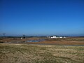
 Boats parked at the Poquoson Marina. Boating has been an important part of Poquoson's economy since its inception. | ||
|
FIPS code 51-63768[2] | | |
| GNIS feature ID | 1479363[3] | |
| Website | http://www.poquoson-va.gov | |
Poquoson (
Poquoson is located on the Virginia Peninsula, in the Hampton Roads metropolitan area.
Poquoson, which was formerly part of York County, became an incorporated town in 1952 and an independent city in 1975. (In Virginia, municipalities incorporated as independent cities are not part of any county.) However, the ties remain close. Over 30 years after Poquoson became a politically independent entity, some constitutional services such as the courts, sheriff and jail continue to be shared with neighboring York County.
Poquoson is one of the oldest continuously named cities in Virginia. It is also one of the few to retain a name which derived from the Native Americans who inhabited the area before colonization by the English began in the 17th century.
History
The name of the city is a
The current city is a remnant of a larger area known from the first days of its settlement in the early 17th century by English colonists as the New Poquoson Parish of the
In 1634, the eight original shires of Virginia were created. Poquoson was located in Charles River Shire. The name was changed to York County in 1642–43. The York River was known earlier as the Charles River, and its name was also changed about the same time.
Poquoson grew as a close-knit rural community of York County for the next 300 years. During the
One of the first land battles of the
Poquoson became an
The changes to incorporated town and independent city were part of a wave of municipal changes in southeastern Virginia in the third quarter of the 20th century. Although Poquoson is one of the smaller of 8 independent cities extant in the Hampton Roads region in the 21st century, it is not unique in the area as a city having large areas of undeveloped land and protected wetlands.
Poquoson has long been informally known as "Bull Island" because for centuries farmers in the area let their cattle roam free in the salt marshes. Although only a few small farms remain and the herd of cattle that once grazed in the marshes are long gone, Poquoson residents still call themselves "Bull Islanders".[8]
Government and law
The Poquoson City Council is composed of seven members who are elected by the voters and serve four-year terms. Elections are held in even-numbered years on the first Tuesday in November. Any Poquoson resident who is at least 18 years of age, is a United States citizen and a resident of Virginia is eligible to be a candidate for election. In 2017, Poquoson residents elected a 19-year-old to the City Council.
The city is divided into three precincts with each precinct having two council representatives. Voters cast their ballots for one candidate from each precinct. One representative is elected at large and serves as City Mayor. Persons elected to City Council take office on the first day of January following the election.
The City Council is the policy making body of the city. Its responsibilities include adoption of the City budget; approval of all tax levies; adoption of ordinances; approval of amendments, supplements or repeals to ordinances and the City Code; and appointment of the City Manager, City Clerk, City Attorney, and various local boards, commissions and committees. [9] The city's school board is appointed by the City Council.
Over 30 years after Poquoson became an independent city from York County, some constitutional services such as the courts, sheriff and jail continue to be shared with neighboring York County.[10]
Politics
Historically, Poquoson voters have trended strongly towards
At the state level, Poquoson is represented by
| Year | Republican | Democratic | Third party | |||
|---|---|---|---|---|---|---|
| No. | % | No. | % | No. | % | |
| 2020 | 5,605 | 71.34% | 2,054 | 26.14% | 198 | 2.52% |
| 2016 | 5,092 | 70.95% | 1,601 | 22.31% | 484 | 6.74% |
| 2012 | 5,312 | 74.75% | 1,679 | 23.63% | 115 | 1.62% |
| 2008 | 5,229 | 74.01% | 1,748 | 24.74% | 88 | 1.25% |
| 2004 | 5,004 | 77.34% | 1,424 | 22.01% | 42 | 0.65% |
| 2000 | 4,271 | 72.87% | 1,448 | 24.71% | 142 | 2.42% |
| 1996 | 3,422 | 64.86% | 1,409 | 26.71% | 445 | 8.43% |
| 1992 | 3,354 | 61.69% | 1,086 | 19.97% | 997 | 18.34% |
| 1988 | 3,840 | 80.83% | 877 | 18.46% | 34 | 0.72% |
| 1984 | 3,667 | 84.73% | 647 | 14.95% | 14 | 0.32% |
| 1980 | 2,338 | 68.78% | 877 | 25.80% | 184 | 5.41% |
| 1976 | 1,461 | 55.34% | 1,140 | 43.18% | 39 | 1.48% |
Media
Poquoson's daily newspaper is the Daily Press. Other papers include the New Journal and Guide, The Virginian-Pilot, and Inside Business.
Poquoson has a weekly paper, The Yorktown Crier / The Poquoson Post.[13] The Hampton Roads Magazine serves as a bi-monthly regional magazine for Poquoson and the Hampton Roads area.[14] Hampton Roads Times serves as an online magazine for all the Hampton Roads cities and counties.[15]
Poquoson is served by a variety of radio stations on the AM and FM dials, with towers located around the Hampton Roads area.[16]
Poquoson is also served by several television stations. The Norfolk-Portsmouth-Newport News
Geography
Poquoson is located at 37°7′59″N 76°22′25″W / 37.13306°N 76.37361°W (37.133153, -76.373881).
According to the United States Census Bureau, the city has a total area of 78 square miles (200 km2), of which 15 square miles (39 km2) is land and 63 square miles (160 km2) (80.4%) is water.[18]
The city is a peninsula containing twenty square miles and is located between the Poquoson River on the north, Back River and Wythe Creek (the Old Poquoson River) on the south, the Chesapeake Bay on the east, and York County on the west. The city also shares a border with the City of Hampton and a water boundary across Chesapeake Bay with Northampton County.
Climate
Poquoson's mild four season climate means outdoor activities can be enjoyed year round. The weather in Poquoson is temperate and seasonal. Summers are hot and humid with cool evenings. The mean annual temperature is 60 °F (16 °C), with an average annual snowfall of 6 inches (15 cm) and an average annual rainfall of 47 inches (1,200 mm). No measurable
Additionally, the geographic location of the city, with respect to the principal storm tracks, is generally favorable, as it is south of the usual path of storms originating in the higher latitudes, and north of the usual tracks of hurricanes and other major tropical storms.
| Month | Jan | Feb | Mar | Apr | May | Jun | Jul | Aug | Sep | Oct | Nov | Dec | Year |
|---|---|---|---|---|---|---|---|---|---|---|---|---|---|
| Record high °F (°C) | 84 (29) |
82 (28) |
92 (33) |
97 (36) |
100 (38) |
102 (39) |
105 (41) |
105 (41) |
100 (38) |
95 (35) |
86 (30) |
82 (28) |
105 (41) |
| Mean maximum °F (°C) | 72.4 (22.4) |
74.3 (23.5) |
80.7 (27.1) |
86.9 (30.5) |
91.5 (33.1) |
95.7 (35.4) |
98.4 (36.9) |
95.3 (35.2) |
92.0 (33.3) |
86.0 (30.0) |
78.9 (26.1) |
73.4 (23.0) |
99.3 (37.4) |
| Mean daily maximum °F (°C) | 50.7 (10.4) |
53.4 (11.9) |
60.1 (15.6) |
70.0 (21.1) |
77.4 (25.2) |
85.2 (29.6) |
89.4 (31.9) |
86.9 (30.5) |
81.4 (27.4) |
72.3 (22.4) |
62.1 (16.7) |
54.7 (12.6) |
70.3 (21.3) |
| Daily mean °F (°C) | 42.2 (5.7) |
44.2 (6.8) |
50.7 (10.4) |
60.1 (15.6) |
68.3 (20.2) |
76.7 (24.8) |
81.1 (27.3) |
79.2 (26.2) |
74.0 (23.3) |
63.7 (17.6) |
53.3 (11.8) |
46.1 (7.8) |
61.6 (16.4) |
| Mean daily minimum °F (°C) | 33.6 (0.9) |
35.1 (1.7) |
41.3 (5.2) |
50.1 (10.1) |
59.1 (15.1) |
68.1 (20.1) |
72.8 (22.7) |
71.6 (22.0) |
66.6 (19.2) |
55.1 (12.8) |
44.4 (6.9) |
37.6 (3.1) |
52.9 (11.6) |
| Mean minimum °F (°C) | 18.7 (−7.4) |
21.6 (−5.8) |
27.4 (−2.6) |
37.0 (2.8) |
46.9 (8.3) |
56.0 (13.3) |
64.7 (18.2) |
63.7 (17.6) |
55.5 (13.1) |
40.4 (4.7) |
29.8 (−1.2) |
23.9 (−4.5) |
16.8 (−8.4) |
| Record low °F (°C) | −3 (−19) |
2 (−17) |
14 (−10) |
23 (−5) |
36 (2) |
45 (7) |
54 (12) |
49 (9) |
40 (4) |
27 (−3) |
17 (−8) |
5 (−15) |
−3 (−19) |
| Average precipitation inches (mm) | 3.41 (87) |
2.90 (74) |
3.69 (94) |
3.37 (86) |
3.78 (96) |
4.43 (113) |
6.08 (154) |
5.88 (149) |
5.40 (137) |
3.86 (98) |
3.10 (79) |
3.28 (83) |
49.18 (1,249) |
| Average snowfall inches (cm) | 3.2 (8.1) |
1.5 (3.8) |
0.4 (1.0) |
0.0 (0.0) |
0.0 (0.0) |
0.0 (0.0) |
0.0 (0.0) |
0.0 (0.0) |
0.0 (0.0) |
0.0 (0.0) |
0.0 (0.0) |
1.1 (2.8) |
6.2 (16) |
| Average precipitation days (≥ 0.01 in) | 10.7 | 9.2 | 10.9 | 10.0 | 11.2 | 9.7 | 10.6 | 10.2 | 9.4 | 7.7 | 8.9 | 9.9 | 118.4 |
| Average snowy days (≥ 0.1 in) | 1.7 | 1.3 | 0.5 | 0.0 | 0.0 | 0.0 | 0.0 | 0.0 | 0.0 | 0.0 | 0.0 | 0.5 | 4.0 |
| Average relative humidity (%)
|
66.3 | 65.6 | 64.6 | 62.8 | 68.8 | 70.6 | 73.3 | 75.2 | 74.4 | 72.1 | 68.5 | 67.0 | 69.1 |
| Average dew point °F (°C) | 27.9 (−2.3) |
28.9 (−1.7) |
35.8 (2.1) |
43.2 (6.2) |
54.5 (12.5) |
63.1 (17.3) |
68.2 (20.1) |
68.0 (20.0) |
62.4 (16.9) |
51.3 (10.7) |
41.7 (5.4) |
32.7 (0.4) |
48.1 (9.0) |
| Mean monthly sunshine hours | 171.5 | 175.2 | 229.3 | 252.8 | 271.7 | 280.1 | 278.3 | 260.4 | 231.4 | 208.3 | 175.7 | 160.4 | 2,695.1 |
| Percent possible sunshine | 56 | 58 | 62 | 64 | 62 | 64 | 62 | 62 | 62 | 60 | 57 | 53 | 61 |
| Average ultraviolet index | 2 | 4 | 5 | 7 | 8 | 10 | 9 | 9 | 7 | 5 | 3 | 2 | 6 |
| Source 1: | |||||||||||||
| Source 2: Weather Atlas (UV)[23] | |||||||||||||
| Climate data for Poquoson, Virginia (1980-2010) | |||||||||||||
|---|---|---|---|---|---|---|---|---|---|---|---|---|---|
| Month | Jan | Feb | Mar | Apr | May | Jun | Jul | Aug | Sep | Oct | Nov | Dec | Year |
| Mean daily maximum °F (°C) | 47.7 (8.7) |
51.1 (10.6) |
59.0 (15.0) |
68.8 (20.4) |
76.5 (24.7) |
84.6 (29.2) |
88.6 (31.4) |
86.3 (30.2) |
80.7 (27.1) |
70.8 (21.6) |
61.2 (16.2) |
51.5 (10.8) |
68.9 (20.5) |
| Mean daily minimum °F (°C) | 28.9 (−1.7) |
31.1 (−0.5) |
37.0 (2.8) |
45.8 (7.7) |
55.0 (12.8) |
64.5 (18.1) |
69.1 (20.6) |
67.5 (19.7) |
61.1 (16.2) |
49.8 (9.9) |
41.0 (5.0) |
32.5 (0.3) |
48.6 (9.2) |
| Average precipitation inches (mm) | 3.6 (91) |
3.4 (86) |
4.4 (110) |
3.3 (84) |
3.9 (99) |
3.5 (89) |
4.6 (120) |
4.7 (120) |
4.2 (110) |
3.4 (86) |
3.3 (84) |
3.4 (86) |
45.7 (1,165) |
| Source: USA.com[24] | |||||||||||||
National protected area
Infrastructure
Poquoson is served by two airports. Newport News/Williamsburg International Airport, located in Newport News, and Norfolk International Airport, in Norfolk, both cater to passengers from Hampton Roads. The primary airport for the Virginia Peninsula is the Newport News/Williamsburg International Airport.
Norfolk International Airport (IATA: ORF, ICAO: KORF, FAA LID: ORF), serves the region. The airport is located near Chesapeake Bay, along the city limits of Norfolk and Virginia Beach.[25] Seven airlines provide nonstop services to twenty five destinations. ORF had 3,703,664 passengers take off or land at its facility and 68,778,934 pounds of cargo were processed through its facilities.[26] The Williamsburg-Jamestown Airport provides general aviation services and is located in Williamsburg.[27]
Amtrak serves nearby Newport News, Virginia and Williamsburg, Virginia with three trains a day. The line runs west along the Virginia Peninsula to Richmond and points beyond. Connecting buses are available to Norfolk and Virginia Beach. A high-speed rail connection at Richmond to both the Northeast Corridor and the Southeast High Speed Rail Corridor are also under study.[28] Poquoson is served by two state highways:
- Route 171, also known as Victory Boulevard entering Poquoson from York County before becoming Little Florida Road, then Poquoson Avenue, and finally Messick Road.[29][30]
- Route 172, also known as Wythe Creek Road entering Poquoson from Hampton before terminating at Yorktown Road and Hunt's Neck Road.[30][31]
The Newport News Waterworks was begun as a project of
The City provides wastewater services for residents and transports wastewater to the regional Hampton Roads Sanitation District treatment plants.[33]
Poquoson has access to four area hospitals, served by Riverside Medical Center and Bon Secours Mary Immaculate Hospital in Newport News and the Sentara Careplex and the V.A. Medical Center in Hampton.[34]
Demographics
| Census | Pop. | Note | %± |
|---|---|---|---|
| 1960 | 4,278 | — | |
| 1970 | 5,441 | 27.2% | |
| 1980 | 8,726 | 60.4% | |
| 1990 | 11,005 | 26.1% | |
| 2000 | 11,566 | 5.1% | |
| 2010 | 12,150 | 5.0% | |
| 2020 | 12,460 | 2.6% | |
| U.S. Decennial Census[35] 1790-1960[36] 1900-1990[37] 1990-2000[38] 2010-2020[39] | |||
2020 census
| Race / Ethnicity | Pop 2010[40] | Pop 2020[39] | % 2010 | % 2020 |
|---|---|---|---|---|
White alone (NH)
|
11,398 | 10,937 | 93.81% | 87.78% |
Black or African American alone (NH)
|
78 | 107 | 0.64% | 0.86% |
Alaska Native alone (NH)
|
34 | 33 | 0.28% | 0.26% |
| Asian alone (NH) | 259 | 253 | 2.13% | 2.03% |
| Pacific Islander alone (NH) | 3 | 2 | 0.02% | 0.02% |
| Some Other Race alone (NH) | 6 | 67 | 0.05% | 0.54% |
| Mixed Race/Multi-Racial (NH) | 151 | 598 | 1.24% | 4.80% |
| Hispanic or Latino (any race) | 221 | 463 | 1.82% | 3.72% |
| Total | 12,150 | 12,460 | 100.00% | 100.00% |
Note: the US Census treats Hispanic/Latino as an ethnic category. This table excludes Latinos from the racial categories and assigns them to a separate category. Hispanics/Latinos can be of any race.
2010 Census

As of the
There were 4,166 households, out of which 39.1% had children under the age of 18 living with them, 69.4% were married couples living together, 8.4% had a female householder with no husband present, and 19.1% were non-families. 15.9% of all households were made up of individuals, and 7.1% had someone living alone who was 65 years of age or older. The average household size was 2.75 and the average family size was 3.08.
In the city, the population was spread out, with 26.8% under the age of 18, 6.4% from 18 to 24, 26.7% from 25 to 44, 28.7% from 45 to 64, and 11.4% who were 65 years of age or older. The median age was 40 years. For every 100 females, there were 100.2 males. For every 100 females age 18 and over, there were 94.4 males.
The median income for a household in the city was $86,611, and the median income for a family was $96,419. Males had a median income of $71,025 versus $43,864 for females. The
Culture

Prior to
The Poquoson Museum,[43] founded in 2003, is located on a 16-acre parcel that contains a circa 1900 farm house, agricultural out buildings, frontage along the marshes of Topping Creek and a country store known as ‘Miss Becky’s Store’ that served local residents for many years. In April 2013 the museum completed work on a marsh walk that incorporates 750 feet of raised platforms with signs highlighting different native wildlife and plant life.[44]
Education
The city is served by Poquoson City Public Schools. There are 4
There are no private schools or colleges in Poquoson and York County. However, there are institutions of each type close by on the Virginia Peninsula. Some of the private schools include Hampton Roads Academy, Our Lady of Mt. Carmel Catholic School, Peninsula Catholic High School, and Denbigh Baptist Christian School, all in Newport News.
Higher education is available at
Sister cities and schools
Poquoson's sister city is:
 Le Bar-sur-Loup, Alpes-Maritimes, France.[52]
Poquoson has two current partner schools.
 Balboa Academy, Panama[53]
 Uruguayan American School, Uruguay[54]
Notable people
- Robinhood co-founder[55]
- Cleveland Indians baseball player[56]
- Kitty O'Brien Joyner, NASA's first female engineer
- Chad Pinder, Oakland Athletics baseball player
Gallery
-
 View from the old Whitehouse Cove public boat ramp
 -
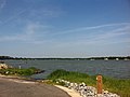
 Poquoson Marina near Owen's Marina and Whitehouse Cove leading out towards the Chesapeake Bay
 -
 Wythe Creek Road approaching the city from Hampton across Brick Kiln Creek
 -
 Boats docked during the winter at Messick Point
 -
 Looking towards the city from Messick Point
 -
 View of the Poquoson River facing towards York County from the end of Hunts Neck Road


Notes
- ^ Mean monthly maxima and minima (i.e. the expected highest and lowest temperature readings at any point during the year or given month) calculated based on data at said location from 1991 to 2020.
- ^ Official records for Norfolk kept January 1874 to December 1945 at the Weather Bureau Office in downtown, and at Norfolk Int'l since January 1946. For more information, see Threadex.
References
- ^ "2019 U.S. Gazetteer Files". United States Census Bureau. Retrieved August 7, 2020.
- ^ "U.S. Census website". United States Census Bureau. Retrieved January 31, 2008.
- ^ "US Board on Geographic Names". United States Geological Survey. October 25, 2007. Retrieved January 31, 2008.
- ^ "Poquoson city, Poquoson city, Virginia". United States Census Bureau. Retrieved January 30, 2022.
- ^ "History". City of Poquoson. Archived from the original on February 25, 2012. Retrieved October 14, 2011.
- ^ "York-Poquoson History".
- ISBN 9780738598352.
- ^ "The "Great Marsh": Poquoson". July 22, 2016.
- ^ "Government Information". City of Poquoson. Archived from the original on November 2, 2012. Retrieved October 14, 2011.
- ^ "Shared Services". City of Poquoson. Archived from the original on April 7, 2012. Retrieved October 14, 2011.
- ^ "Senate Districts". Virginia State Senate. Retrieved August 26, 2013.
- ^ Leip, David. "Atlas of US Presidential Elections". uselectionatlas.org. Retrieved February 5, 2023.
- ^ "The Yorktown Crier / The Poquoson Post". The Yorktown Crier. Retrieved May 21, 2013.
- ^ "Hampton Roads Magazine". Hampton Roads Magazine. Archived from the original on September 28, 2007. Retrieved May 21, 2013.
- ^ "Hampton Roads Times". Hampton Roads Times. Archived from the original on October 13, 2018. Retrieved May 21, 2013.
- ^ "Hampton Roads Radio Links". ontheradio.net. Retrieved May 21, 2013.
- ^ "http://tvbythenumbers.zap2it.com/2012/08/31/nielsen-local-television-market-universe-estimates-for-2012-13/146976/ Archived 2013-05-21 at the Wayback Machine Nielsen Local Television Market Universe Estimates For 2012-13]." Nielsen Media Research. August 31, 2012. Retrieved on May 21, 2013.
- ^ "US Gazetteer files: 2010, 2000, and 1990". United States Census Bureau. February 12, 2011. Retrieved April 23, 2011.
- ^ a b "NowData – NOAA Online Weather Data". National Oceanic and Atmospheric Administration. Retrieved May 18, 2021.
- ^ Information from NOAA.
- ^ "Station: NORFOLK INTL AP, VA". U.S. Climate Normals 2020: U.S. Monthly Climate Normals (1991–2020). National Oceanic and Atmospheric Administration. Retrieved May 18, 2021.
- ^ "WMO Climate Normals for NORFOLK/INTL, VA 1961–1990". National Oceanic and Atmospheric Administration. Retrieved July 29, 2020.
- ^ "Norfolk, Virginia, USA - Monthly weather forecast and Climate data". Weather Atlas. Retrieved July 3, 2019.
- ^ "Climatological Information for Poquoson, Virginia", USA.com, 2003. Web: [1].
- ^ "Norfolk International Airport Mission and History". Norfolk International Airport. Archived from the original on September 28, 2007. Retrieved October 2, 2007.
- ^ "Norfolk International Airport Statistics" (PDF). Norfolk International Airport. Archived from the original (PDF) on October 25, 2007. Retrieved October 2, 2007.
- ^ "Williamsburg-Jamestown Airport". Retrieved January 12, 2008.
- ^ "Southeast High Speed Rail". Southeast High Speed Rail. Archived from the original on May 15, 2013. Retrieved October 15, 2007.
- ^ 2005 Virginia Department of Transportation Jurisdiction Report - Daily Traffic Volume Estimates - Warwick Maintenance Area
- ^ a b 2005 Virginia Department of Transportation Jurisdiction Report - Daily Traffic Volume Estimates - York County
- ^ 2005 Virginia Department of Transportation Jurisdiction Report - Daily Traffic Volume Estimates - Elizabeth City Maintenance Area
- ^ Waterworks — City of Newport News Waterworks
- ^ "Hampton Roads Sanitation District". Hampton Roads Sanitation District. Retrieved March 8, 2008.
- ^ "Virginia Hospitals and Medical Centers". The Agape Center. Retrieved August 6, 2007.
- US Census Bureau. Retrieved January 24, 2022.
- ^ "Historical Census Browser". University of Virginia Library. Retrieved January 6, 2014.
- ^ "Population of Counties by Decennial Census: 1900 to 1990". United States Census Bureau. Retrieved January 6, 2014.
- ^ "Census 2000 PHC-T-4. Ranking Tables for Counties: 1990 and 2000" (PDF). United States Census Bureau. Archived (PDF) from the original on October 9, 2022. Retrieved January 6, 2014.
- ^ a b "P2 HISPANIC OR LATINO, AND NOT HISPANIC OR LATINO BY RACE - 2020: DEC Redistricting Data (PL 94-171) - Poquoson city, Virginia". United States Census Bureau.
- ^ "P2 HISPANIC OR LATINO, AND NOT HISPANIC OR LATINO BY RACE - 2010: DEC Redistricting Data (PL 94-171) - Poquoson city, Virginia". United States Census Bureau.
- ^ "U.S. Census website". United States Census Bureau. Retrieved May 14, 2011.
- ^ "Poquoson Seafood Festival". City of Poquoson. Retrieved May 21, 2013.
- ^ "Poquoson Museum". City of Poquoson. Retrieved May 21, 2013.
- ^ "Poquoson Museum to debut new marsh walk, book." Daily Press. April 11, 2013. Retrieved on May 21, 2013.
- ^ "Poquoson City Schools". City of Poquoson School Board. Retrieved July 8, 2007.
- ^ Christopher Newport University
- ^ College of William and Mary
- ^ Old Dominion University
- ^ Norfolk State University
- ^ Hampton University
- ^ Thomas Nelson Community College
- ^ "Le Bar Sur Loup" (in French). Association du Clue Des Jeunes du Bar Sur Loup. Archived from the original on July 2, 2007. Retrieved July 8, 2007.
- ^ "AAIE Spring Newsletter 2007" (PDF). Association for the Advancement of International Education. Archived from the original (PDF) on August 9, 2007. Retrieved July 8, 2007.
- ^ "Uruguayan American School". City of Poquoson School Board. Archived from the original on August 2, 2007. Retrieved July 8, 2007.
- ^ "I'm Baiju Bhatt, Robinhood CEO, and This Is How I Work". lifehacker.com. August 2, 2017. Retrieved September 1, 2020.
- ^ "Kyle Crockett and Chad Pinder led Poquoson to a second consecutive baseball state title - Daily Press". Articles.dailypress.com. June 19, 2010. Retrieved November 14, 2013.
External links
- City of Poquoson
- Poquoson City Public Schools
- Poquoson.com
- Poquoson, Virginia at Curlie
- Hampton Roads Economic Development Alliance - serving Poquoson
37°07′59″N 76°22′26″W / 37.133153°N 76.373881°W
Places adjacent to Poquoson, Virginia | |
|---|---|
| Cities | |
|---|---|
| Counties | |
| Towns | |
| Sub-regions | |
| Topics | |
| See Also | |
Note: Cities are independent, not being part of any county | |
| International | |
|---|---|
| National | |
| Geographic | |