
Rajdher fort
This article needs additional citations for verification. (July 2017) |
| Rajdeher Fort | |
|---|---|
राजधेर किल्ला | |
| Part of Ajintha Satmal Hill Range | |
| |
| Open to the public | Yes |
| Condition | Ruins |
| Site history | |
| Materials | Stone |
Rajdeher Fort (Marathi: राजधेर किल्ला) is a fort located 10 km (6.2 mi) from chandwad, Nashik district, of Maharashtra. This fort is an important fort in Nashik district.
History
This fort was built earlier than
How to reach
The nearest town is Chandwad which is 66 km from Nashik. The base village of the fort is Rajdeherwadi which is 11 km from Chandwad. There are good hotels at Chandwad. The trekking path starts from the hillock west of the Rajdeherwadi. The route is very safe and wide. There are no trees on the trekking route. It takes about two hours to reach the entrance gate of the fort. The path is marked with limestone markings. The trek path is very clearly seen from the base village. The night stay on the fort can be made in the caves on the fort, however, the stay at the temple in the base village is a routine night stay halt for the trekkers. The villagers from the local village make night stay and food arrangements at a reasonable cost.
Places to see
There is a single gate on the main entrance path of the fort. The main entrance gate has an inscription in Persian. There is a rock cut water cistern on the fort. The water is available round the year for drinking purpose. It takes about one hour to visit the fort top.
Gallery
-
 Climb to the entrance of fort
 -
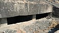 Rockcut underground Water cistern
 -
 Top of the fort
 -
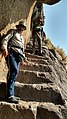 The rock cut steps
 -
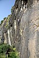
 The trek path
 -
 water cistern
 -
 Inscription in Persian


Nearest Villages
Rajdher wadi
Kapshi
See also
- List of forts in Maharashtra
- List of forts in India
- Baji Rao II
- Marathi People
- Maratha Navy
- List of Maratha dynasties and states
- Maratha War of Independence
- Battles involving the Maratha Empire
- Maratha Army
- Maratha titles
- Military history of India
- List of people involved in the Maratha Empire
References
- ^ "Rajdeher, Western Ghats, Sahyadri, Adventure, Trekking". trekshitiz.com.