
Palatka, Florida
Palatka, Florida | ||
|---|---|---|
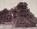
Bronson-Mulholland House | ||
|
FIPS code 12-53875[2] | | |
| GNIS feature ID | 0288381[3] | |
| Website | palatka-fl.gov | |
Palatka (
History

The area was once the domain of the
During the late eighteenth century, Creek tribes made their way to Florida. In a process of ethnogenesis, the Seminole tribe was formed. They called the location Pilo-taikita, meaning "crossing over" or "cows' crossing". Here the St. Johns River narrows and begins a shallower, winding course upstream to Lake George and Lake Monroe.
In 1767,
He built a mansion and laid out a village, but trouble beleaguered the "ideal society". In 1770, a disgruntled overseer sold over 1,000 of his employer's cattle and disappeared with the money. Rolle hired new overseers and bought more slaves, but the plantation failed to prosper. When Spain resumed control of Florida in 1783, Rolle abandoned the colony and chartered a ship to carry his household belongings, livestock and slaves to a 2,000-acre (8.1 km2) estate on
With control by different powers in Florida came changes of ownership in Pilo-taikita, now contracted to Pilatka. In 1774, naturalist William Bartram noted an Indian village on the west bank, but it was abandoned later . The current existence of Palatka can be traced to the settlement established there in 1821.[4] After the United States acquired Florida in 1821, Nehemiah Brush established a ferry and bought a 1,200-acre (4.9 km2) tract in 1826 and another of equal size the next year. The site became a distribution point, where goods were shipped by a New York company to supply immigrants at the Grant of Arredondo, which lay to the west.
The arrival of land-hungry American settlers created confrontations with the resident Seminole. When the government attempted to relocate the tribe to the west of the Mississippi as part of


During the 1850s, Florida in general and Pilatka in particular gained a reputation as a haven for invalids escaping northern winters. Steamboats carried them up the river in increasing numbers. One visitor wrote that amusements included "sailing, fishing, rowing, walking, riding in buggies and on horseback, whist, euchre, backgammon and hunting".
The tourist trend was interrupted by the Civil War, when gunboats cruised the waters and Pilatka was destitute and largely deserted. On October 7, 1862, the USS Cimarron fired several shells over the town after seeing some Confederate cavalry. Mary Boyd pleaded with Union Commander Maxwell Woodhull to spare Pilatka, assuring him that the horse soldiers were not residents. He complied.
Among the notable residents of Pilatka during the war was Confederate spy
Following the war, the tourists returned, and new accommodations were constructed including the Putnam House, built by Hubbard L. Hart, and the Larkin House, which could accommodate 250 guests. Steamers ran up the Ocklawaha River to Eustis, Leesburg and Silver Springs, or the St. Johns River to Enterprise and Sanford. Industries included logging, raising cattle and hogs, and orange groves. On May 24, 1875, the post office changed the spelling to Palatka.
By the 1880s, several competing
In 1893, A. E. and H. S. Wilson of
Geography
Palatka is located at 29°38′N 81°39′W / 29.633°N 81.650°W. The total area is 7.5 square miles (19 km2) and has an average elevation of 16 feet (4.8 m)
Places adjacent to Palatka, Florida | |
|---|---|
Climate
Palatka has a humid subtropical climate, Köppen climate classification Cfa. The area's warm and humid climate is caused primarily by its proximity to the Gulf Stream, which flows off the east coast of Florida. There are two major seasons which characterize the area. One is hot and rainy, lasting from June until late September. The other is the dry season, October through May, which brings more moderate temperatures and less frequent rainfall.
| Climate data for Palatka, Florida (1922–2004) | |||||||||||||
|---|---|---|---|---|---|---|---|---|---|---|---|---|---|
| Month | Jan | Feb | Mar | Apr | May | Jun | Jul | Aug | Sep | Oct | Nov | Dec | Year |
| Record high °F (°C) | 90 (32) |
90 (32) |
94 (34) |
96 (36) |
103 (39) |
105 (41) |
103 (39) |
102 (39) |
100 (38) |
98 (37) |
90 (32) |
86 (30) |
105 (41) |
| Mean daily maximum °F (°C) | 69.4 (20.8) |
72.0 (22.2) |
77.3 (25.2) |
82.8 (28.2) |
88.0 (31.1) |
91.2 (32.9) |
92.4 (33.6) |
92.1 (33.4) |
88.9 (31.6) |
82.9 (28.3) |
75.8 (24.3) |
70.5 (21.4) |
81.9 (27.8) |
| Daily mean °F (°C) | 57.9 (14.4) |
59.9 (15.5) |
64.9 (18.3) |
70.5 (21.4) |
76.3 (24.6) |
80.8 (27.1) |
82.4 (28.0) |
82.3 (27.9) |
79.8 (26.6) |
72.9 (22.7) |
64.5 (18.1) |
59.2 (15.1) |
71.0 (21.6) |
| Mean daily minimum °F (°C) | 45.7 (7.6) |
47.8 (8.8) |
52.6 (11.4) |
58.3 (14.6) |
64.6 (18.1) |
70.6 (21.4) |
72.4 (22.4) |
72.5 (22.5) |
70.7 (21.5) |
62.8 (17.1) |
53.1 (11.7) |
47.9 (8.8) |
59.9 (15.5) |
| Record low °F (°C) | 11 (−12) |
21 (−6) |
21 (−6) |
35 (2) |
43 (6) |
55 (13) |
60 (16) |
62 (17) |
55 (13) |
37 (3) |
23 (−5) |
16 (−9) |
11 (−12) |
| Average precipitation inches (mm) | 2.69 (68) |
3.19 (81) |
3.73 (95) |
3.08 (78) |
3.61 (92) |
6.65 (169) |
7.22 (183) |
7.10 (180) |
7.31 (186) |
3.81 (97) |
1.94 (49) |
2.54 (65) |
52.87 (1,343) |
| Average precipitation days (≥ 0.01 in) | 6.7 | 6.4 | 6.8 | 5.4 | 7.6 | 12.5 | 15.0 | 14.3 | 12.6 | 8.4 | 5.5 | 6.1 | 107.3 |
| Source: NOAA[7] | |||||||||||||
Cityscape

As with many cities in the United States, development has occurred in a radial pattern from the city center to beyond the incorporated area. Due to the historical importance of Palatka as a southeastern interior port, much of the urban development is oriented toward the riverfront. The eastern sections of the city, which include downtown and the historic districts, are characterized by a gridded street system. A significant amount of the original brick roads survive in this area. The western outlying suburban areas are primarily characterized by an amorphous road pattern.[8]
The city of Palatka is actively working toward redevelopment of its riverfront and downtown area.[9] The rise of the automobile, and the inevitable shift to a big-box economic format, has taken its toll on the once thriving regional center. Like many other American cities, Palatka's downtown has had to repurpose itself to cope with an auto-centric society.
Architecture

Several architectural styles are represented within the city.
Though there are no discernible architectural styles in the outgrowth areas, a notable building technique has been used in the construction of the 23,000-square-foot (2,100 m2) Children's Reading Center Charter School. Five monolithic dome structures crown the facility and give it a distinct style.[12]
Neighborhoods
Parks and Gardens
- James C. Godwin Riverfront Park
- Hank Bryan Park
- Ravine Gardens State Park
- Veteran's Memorial Park
Museums in Palatka
- Bronson Mulholland House
- St Johns River Center
- Putnam Historic Museum
- Mariners Museum Inc.
Library
With up to sixteen hundred people employed by the mills of the Wilson Cypress Company in its heyday, the town of Palatka was in need of a space to further the education of its young working men.[13] Although some library supporters, such as Betty P. Welch, wrote letters to library sympathizers such as Andrew Carnegie in search of funding, the funds for the first Palatka Public Library were provided by James Ross Mellon, the son of the famous Judge Thomas Mellon of Pittsburgh, who regularly wintered in Florida.[14] Founded in 1930, the Larimer Library was gifted in commemoration of James Mellon’s wife, Rachel Larimer, and was revered as a “poor man’s university” and “the rock on which to build an enlightened citizenry.”[14] Today the Larimer Memorial Library contains an arts center, and the Palatka Public Library was moved to the campus of the St. Johns River Community College.[14]
Demographics
| Census | Pop. | Note | %± |
|---|---|---|---|
| 1860 | 613 | — | |
| 1870 | 720 | 17.5% | |
| 1880 | 1,616 | 124.4% | |
| 1890 | 3,039 | 88.1% | |
| 1900 | 3,301 | 8.6% | |
| 1910 | 3,779 | 14.5% | |
| 1920 | 5,102 | 35.0% | |
| 1930 | 6,500 | 27.4% | |
| 1940 | 7,140 | 9.8% | |
| 1950 | 9,176 | 28.5% | |
| 1960 | 11,028 | 20.2% | |
| 1970 | 9,444 | −14.4% | |
| 1980 | 10,175 | 7.7% | |
| 1990 | 10,201 | 0.3% | |
| 2000 | 10,033 | −1.6% | |
| 2010 | 10,558 | 5.2% | |
| 2020 | 10,446 | −1.1% | |
| U.S. Decennial Census[15] | |||
2010 and 2020 census
| Race | Pop 2010[16] | Pop 2020[17] | % 2010 | % 2020 |
|---|---|---|---|---|
White (NH)
|
4,622 | 3,963 | 43.78% | 37.94% |
Black or African American (NH)
|
5,200 | 5,163 | 49.25% | 49.43% |
Alaska Native (NH)
|
30 | 45 | 0.28% | 0.43% |
| Asian (NH) | 60 | 85 | 0.57% | 0.81% |
Native Hawaiian (NH)
|
2 | 2 | 0.02% | 0.02% |
Some other race (NH)
|
17 | 52 | 0.16% | 0.50% |
| Two or more races/Multiracial (NH) | 144 | 331 | 1.36% | 3.17% |
| Hispanic or Latino (any race) | 483 | 805 | 4.57% | 7.71% |
| Total | 10,558 | 10,446 |
As of the 2020 United States census, there were 10,446 people, 4,419 households, and 2,088 families residing in the city.[18]
As of the 2010 United States census, there were 10,558 people, 4,113 households, and 2,466 families residing in the city.[19]
2000 census
As of the census of 2000, there are 10,033 people, 3,880 households, and 2,421 families residing in the city. The population density was 1,442.1 inhabitants per square mile (556.8/km2). There were 4,318 housing units at an average density of 620.7 per square mile (239.7/km2). The racial makeup of the city was 48.93%
In 2000, there were 3,880 households, out of which 31.5% had children under the age of 18 living with them, 34.0% were married couples living together, 24.9% had a female householder with no husband present, and 37.6% are other types of families. 32.7% of all households were made up of individuals, and 16.5% had someone living alone who was 65 years of age or older. The average household size was 2.42 and the average family size was 3.10.
In 2000, in the city, the population was spread out, with 28.6% under the age of 18, 10.1% from 18 to 24, 24.6% from 25 to 44, 19.0% from 45 to 64, and 17.7% who were 65 years of age or older. The median age was 34 years. For every 100 females, there were 81.9 males. For every 100 females age 18 and over, there were 75.8 males.
In 2000, the median income for a household in the city was $18,129, and the median income for a family was $26,076. Males had a median income of $27,716 versus $19,187 for females. The
Government

Palatka uses the
|
|
Infrastructure
Health care
Local health care is provided by the HCA Florida Putnam Hospital. The 99-bed acute care facility offers a medical and surgical units, 24-hour emergency department, critical care unit, skilled nursing unit, and progressive care unit. Other services include a diagnostic imaging department and an outpatient rehabilitation facility.[22] Located in Palatka, the medical center services all of Putnam County. The local health department is located at 2801 Kennedy Street in Palatka.[23]
Education

The main center for higher education in the city is
Transportation

Transportation has been key in the development of Palatka since the day of its inception.
- Highways
 US 17 – Primary north-south route running parallel with the St. Johns River. This route connects Palatka to Jacksonville (northbound) and Orlando (southbound).
 SR 15 – From Jacksonville to Orlando US 17 and SR 15 are the same route.
 SR 19 – Terminating into US 17, SR 19 extends into the cities major commercial corridor. The route extends further into the Ocala National Forest and becomes the Florida Black Bear Scenic Byway.
 SR 20 – Primary route connecting Gainesville and Palatka.
 SR 100 – Route connecting Keystone Heights, Palatka, and Bunnell
 SR 207 – Primary route connecting East Palatka and St. Augustine
The bundled US 17, SR 20 and SR 100 cross the Memorial Bridge over the St. Johns River toward East Palatka.
- Mass transit
Bus transportation in the city is provided by
- Intercity transit
Palatka Municipal Airport is a public-use, general aviation airport located 2 miles (3.2 km) northwest of Downtown Palatka. The nearest international airport is Jacksonville International Airport, approximatively 68 miles (109 km) north of Palatka. The closest major international airport is Orlando International Airport.
Economy
The composition of the Palatka area economy is unreflective of Florida as a whole. Unlike many cities in the state, Palatka has a large manufacturing sector, employing 17.2% of the city's total civilian workforce.
The Palatka area was of early significance in accessing the interior of the state. This significance was due to its location at the end of an expansive portion of waterway at the divide between the upper and lower St. Johns River. First established as a trading outpost, tourism would eventually boom and fuel growth for decades. The decline of waterborne travel in Northeast Florida, and the United States in general, ultimately reduced the importance of tourism in the city. Nowadays, large international airports and bypassing interstate highways carry vacationers to destinations further south. Only 7.1% of Palatka's labor force works in arts, entertainment, recreation, accommodation, and food services,[34] compared to Florida's 15.5% across tourist related industries.[35]
In recent years, the Putnam County government has adopted policies focused on facilitating
Of residents aged 16 years and over, 53.3% were in the labor force; 45.6% were employed and 7.6% unemployed.
Sites of interest
The following entries are listed on the National Register of Historic Places:
- Old Atlantic Coast Line Union Depot, home of the Palatka Railroad Preservation Society
- Bronson-Mulholland House (1854), home of the Putnam County Historical Society & Museum
- Central Academy, Florida's first accredited African-American high school
- Larimer Memorial Library
- Palatka North Historic District
- Palatka South Historic District
- Ravine Gardens State Park
- St. Mark's Episcopal Church
Gallery
-
 Palmetto glade in 1893
 -
 Orange grove in 1893
 -
 Steamer Hiawatha in 1905
 -
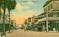 Lemon Street in 1915


Sister cities
Palatka has one
See also
References
- ^ "2020 U.S. Gazetteer Files". United States Census Bureau. Retrieved October 31, 2021.
- ^ "U.S. Census website". United States Census Bureau. Retrieved January 31, 2008.
- ^ "US Board on Geographic Names". United States Geological Survey. October 25, 2007. Retrieved January 31, 2008.
- ^ Columbia-Lippincott Gazetteer, p. 1413.
- ISBN 0-8359-0641-8.
- ^ "Hispanic Confederate Heritage – The Sanchez sisters" by Rebecca M. Cuevas De Caissie.
- ^ "xmACIS2 - Monthly Summarized Data". National Oceanic and Atmospheric Administration. Retrieved February 24, 2023.
- ^ University of Florida [1], Palatka, a regional study of architectural history, 1977.
- ^ Palatka Daily News January 12, 2011, New Palatka mayor says downtown is No. 1[permanent dead link].
- ^ Prairie School Traveler, James Hotel.
- ^ RET-TBD, Larimer Arts Archived 2011-07-15 at the Wayback Machine.
- ^ Putnam County School District, , Children's Reading Center Charter School, Our School.
- ^ Belleville, B (2011). Palatka to Picolata. University of Georgia Press. p. 141.
- ^ a b c Michaels, B. The River Flows North. Putnam County Public Library.
- ^ "Census of Population and Housing". Census.gov. Retrieved June 4, 2015.
- ^ "P2 HISPANIC OR LATINO, AND NOT HISPANIC OR LATINO BY RACE - 2010: DEC Redistricting Data (PL 94-171) - Palatka city, Florida". United States Census Bureau.
- ^ "P2 HISPANIC OR LATINO, AND NOT HISPANIC OR LATINO BY RACE - 2020: DEC Redistricting Data (PL 94-171) - Palatka city, Florida". United States Census Bureau.
- ^ "S1101 HOUSEHOLDS AND FAMILIES - 2020: Palatka city, Florida". United States Census Bureau.
- ^ "S1101 HOUSEHOLDS AND FAMILIES - 2010: Palatka city, Florida". United States Census Bureau.
- ^ "City of Palatka: Commission". City of Palatka. Retrieved January 23, 2011.
- ^ "Palatka City Commission Calendar" (PDF). City of Palatka. Archived from the original (PDF) on August 24, 2011. Retrieved January 23, 2011.
- ^ Specialty Services. Archived 2010-12-19 at the Wayback Machine at [2], retrieved 24.01.2011.
- ^ Putnam County Health Department. Archived at Florida Department of Health, retrieved 24.01.2011.
- ^ About Us. Archived 2011-07-20 at the Wayback Machine. Archived at St. Johns River River State College. Archived 2011-02-26 at the Wayback Machine, retrieved 24.01.2011.
- ^ School Matters [3][permanent dead link], Classroom Profile, Enrollment.
- ^ High School. Archived 2015-02-02 at the Wayback Machine, About PHS.
- ^ Board of County Commissioners [4]. Archived 2014-08-19 at the Wayback Machine, Putnam County Florida E-Governance, Library Department.
- ^ Community Transportation Association (archived), Rep. Mica, Ride Solution Unveil New Brevi Bus, October 15, 2010, retrieved 24.01.2011.
- ^ "PALATKA FLORIDA (PAC)". TrainWeb. Retrieved August 7, 2010.
- ^ "American Factfinder; Palatka". United States Census Bureau. 2005–2009. Archived from the original on February 10, 2020. Retrieved February 3, 2011.
- ^ "American Factfinder; Florida". United States Census Bureau. 2005–2009. Archived from the original on February 10, 2020. Retrieved February 3, 2011.
- ^ "Putnam County Profile". eflorida. Retrieved February 3, 2011.
- ^ "Who we are". PDM Bridge, LLC. Archived from the original on March 19, 2012. Retrieved February 3, 2011.
- ^ "American Factfinder; Palatka Economic Data". United States Census Bureau. 2005–2009. Archived from the original on February 10, 2020. Retrieved February 3, 2011.
- ^ "American Factfinder; Florida Economic Data". United States Census Bureau. 2005–2009. Archived from the original on February 10, 2020. Retrieved February 3, 2011.
- ^ "Putnam County Trails Master Plan" (PDF). Putnam County Board of County Commissioners. 2009. Archived from the original (PDF) on August 19, 2014. Retrieved February 3, 2011.
- ^ "About Your Putnam Land Conservancy". Putnam Land Conservancy, Inc. February 2, 2011. Retrieved February 3, 2011.
- ^ "Overview and mission". St. Johns River Water Management District. 2010. Archived from the original on December 22, 2010. Retrieved February 3, 2011.
- ^ "American Factfinder". United States Census Bureau. 2005–2009. Archived from the original on February 10, 2020. Retrieved February 3, 2011.
- ^ "American Factfinder". United States Census Bureau. 2005–2009. Archived from the original on February 10, 2020. Retrieved February 3, 2011.
- ^ "Florida". U.S. Bureau of Labor Statistics. December 2010. Retrieved February 3, 2011.
- ^ "Local Area Unemployment Statistics; Palatka". U.S. Bureau of Labor Statistics. December 2010. Retrieved February 3, 2011.
- ^ "Local Area Unemployment Statistics; Gainesville". U.S. Bureau of Labor Statistics. December 2010. Retrieved February 3, 2011.
- ^ "Local Area Unemployment Statistics; Palm Coast". U.S. Bureau of Labor Statistics. December 2010. Retrieved February 3, 2011.
- ^ Sister Cities. State of Florida (June 13, 2004). Archived from My Florida. Retrieved on 2011-01-20.
External links
- City of Palatka
- Palatka Daily News
- Historic issues of the Palatka Daily News (1884-1888), Palatka News (1905, 1907), Palatka News and Advertiser (1902-1905, 1910-1917), and the Palatka Daily News (1919, 1921-1922) at Florida and Puerto Rico Digital Newspaper Project
- Palatka Florida local guide
- St. Johns River State College
- Palatka Florida Community News
- Palatka Bluegrass Festival
- Ride Solution local public transit
 Palatka travel guide from Wikivoyage
Municipalities and communities of Putnam County, Florida, United States | ||
|---|---|---|
| Cities |  | |
| Towns | ||
| CDP | ||
| Unincorporated communities | ||
| Footnotes | ‡This populated place also has portions in an adjacent county or counties | |
| ||
| Topics |  Map of North Florida | |
|---|---|---|
| Counties | ||
| Major cities | ||
| Cities and towns 50k–100k | ||
| Cities and towns 10k–40k | ||
| Metro areas |
| |
| Regions |
| |
| Counties |  | |
|---|---|---|
| Cities, towns and CDPs | ||
| International | |
|---|---|
| National | |
| Geographic | |