
Texas Blackland Prairies
| Texas Blackland Prairies | |
|---|---|
Nearctic | |
| Biome | Temperate grasslands, savannas, and shrublands |
| Borders |
|
| Bird species | 216[1] |
| Mammal species | 61[1] |
| Geography | |
| Area | 50,300 km2 (19,400 sq mi) |
| Country | United States |
| State | Texas |
| Climate type | Humid subtropical (Cfa) |
| Conservation | |
| Habitat loss | 76.458%[1] |
| Protected | 0.64%[1] |
The Texas Blackland Prairies are a temperate grassland ecoregion located in Texas that runs roughly 300 miles (480 km) from the Red River in North Texas to San Antonio in the south. The prairie was named after its rich, dark soil.[3] Less than 1% of the original Blackland prairie vegetation remains, scattered across Texas in parcels.[4]
Setting
The Texas Blackland Prairies ecoregion covers an area of 50,300 km2 (19,400 sq mi), consisting of a main belt of 43,000 km2 (17,000 sq mi) and two islands of
The main belt consists of oaklands and
The larger of the two islands is the Fayette Prairie, encompassing 17,000 km2 (6,600 sq mi), and the smaller is the San Antonio Prairie, with an area of 7,000 km2 (2,700 sq mi). The two islands are separated from the main belt by the oak woodlands of the East Central Texas forests, which surround the islands on all sides but the northeast, where the Fayette Prairie meets the East Texas Piney Woods.
Texas counties that once supported blackland prairies include all or most of Collin, Dallas, Delta, Ellis, Hunt, Kaufman, Navarro, and Rockwall counties, as well as portions of Bastrop, Bell, Bexar, Caldwell, Denton, Falls, Fannin, Franklin, Freestone, Grayson, Guadalupe, Henderson, Hill, Hopkins, Johnson, Lamar, Limestone, McLennan, Milam, Rains, Red River, Tarrant, Titus, Travis, Van Zandt, and Williamson counties, all in the northwestern band of the region. The smaller southeastern band includes much of Grimes and Washington counties as well as portions of Austin, Colorado, Fayette, and the northwestern half of Lavaca county.[5]: 311 p. Sources and maps vary on the exact boundaries of the Blackland Prairie, and some may include or exclude different portions of peripheral counties.
History
_(19807535823).jpg)
Early
The U. S. Bureau of Biological Survey [now the
Ecology
The Blackland Prairie was a disturbance maintained
The soil of the Blackland Prairies, from which the "blackland" gets its name, contains black or dark-gray, alkaline clay in both upland and bottomland areas.
The rich black 'waxland' soil of these prairies is almost proof against burrowing rodents, which penetrate the region only along some sandy stream bottoms, while the open country tempts jack rabbits, coyotes, and other plains species eastward slightly beyond their usual bounds. Few, if any, species are restricted to these prairie, however, and the effect on distribution is mainly negative." [7]: 19 p.
The negative effect on distribution is evident in the Texas distribution of many wide-ranging species of both eastern and western North American fauna reaching their respective distributional limits in the region of the Texas Blackland Prairies and
Flora
Important prairie plants included little bluestem, yellow indiangrass, big bluestem, tall dropseed, and a variety of wildflowers including gayfeathers, asters, Maximilian sunflower, wild indigos and compass plant.
Fauna

Mammals: Some species found in the region include Virginia opossum (
The large,

Birds: With spring and fall migrants, wintering species, breading and summer species, well over 325 species of birds occur in the region. Various seasonal and migratory species appearing in the region include Bufflehead (
A few of the year round resident species include wood duck (
.jpg)
Reptiles: Although not particularly abundant, the American alligator (
Snakes are the most diverse group of reptiles in the region, species include the North American racer (
Amphibians: Frogs and toads in the region include the American bullfrog (
_2_(4015397483).jpg)
Fish: Among the many fish of the region are spotted bass (
Just a few of the smaller species include threadfin shad (
Conservation
Because of the soil and climate, this ecoregion is ideally suited to crop agriculture. This has led to most of the Blackland Prairie
Protected areas
The
The
.jpg)
- Texas Blackland Prairies
- Bonham State Park (261 acres)
- Cedar Creek Islands Wildlife Management Area(160 acres)
- Cedar Hill State Park (1,826 acres)
- Cooper Lake State Park (3,026 acres) U.S. Army Corps of Engineers*
- Cooper Wildlife Management Area(14,480 acres) U.S. Army Corps of Engineers*
- Lake Tawakoni State Park (376 acres), Sabine River Authority of Texas*
- Tawakoni Wildlife Management Area(2,335 acres), Sabine River Authority of Texas (1,561 acres)*
- Lockhart State Park (? acres)
- Purtis Creek State Park (1,582 acres)
- Peripheral areas
.jpg)
- Caddo National Grasslands Wildlife Management Area(16,174 acres), U.S. Forest Service*
- Eisenhower State Park (463 acres), U.S. Army Corps of Engineers*
- Fort Parker State Park (ca. 1500 acres)
- Lake Bob Sandlin State Park (640 acres)
- Lake Summerville State Park (? acres), U.S. Army Corps of Engineers*
- McKinney Falls State Park (641 acres)
- Mother Neff State Park (400 acres)
- Richland Creek Wildlife Management Area(13,783 acres)
Gallery
-
 Ranchland seen from Highway 916 east of Grandview, Johnson County, Texas, USA (26 June 2021)
 -
 Ranch and pastureland seen from Highway 339, Limestone County Texas, USA USA (26 June 2021)
 -
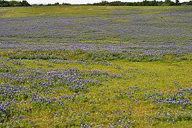
 Ranchland in the Blackland Prairie eco-region of Texas with Texas bluebonnets (Lupinus texensis), Washington County, Texas, USA (30 March 2012).
 -
 Washington-on-the-Brazos State Historic Site, Washington County, Texas, USA (30 March 2012).
 -
 Farmland in the Blackland Prairie region seen from Highway 123, Guadalupe County, Texas, USA (9 July 2020)
 -
 Texas bluebonnets (Lupinus texensis) in the Blackland Prairie eco-region, Highway 532 east of Gonzales, Gonzales County, Texas, USA (19 April 2014).
 -
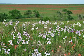 Fox Glove (Penstemon cobaea) on ranchland in the Blackland Prairie eco-region. County Road 269, Lavaca County, Texas, USA (19 April 2014).
.jpg)

,_Washington_County,_Texas,_USA_(30_March_2012).jpg)
.jpg)
.jpg)
_in_the_Blackland_Prairie_eco-region._Highway_532_east_of_Gonzalez,_Gonzalez_County,_Texas,_USA_(19_April_2014).jpg)
_on_ranchland_in_the_Blackland_Prairie_eco-region._County_Road_269,_Lavaca_County,_Texas,_USA_(19_April_2014).jpg)
See also
References
- ^ a b c d
Hoekstra, J. M.; Molnar, J. L.; Jennings, M.; Revenga, C.; Spalding, M. D.; Boucher, T. M.; Robertson, J. C.; Heibel, T. J.; Ellison, K. (2010). Molnar, J. L. (ed.). The Atlas of Global Conservation: Changes, Challenges, and Opportunities to Make a Difference. ISBN 978-0-520-26256-0.
- ^ a b c "Ecoregions of Texas" (PDF). U.S. EPA. Retrieved 2016-02-06.
- ^ "Blackland Prairies". Invasives 101. Texas Invasives. Retrieved 2017-02-06.
- ^ a b c d D’Annunzio, Francesca (2021-12-28). "North America's Most Endangered Ecoregion is in North Texas' Backyard". Dallas News.
- ^ ISBN 0-89672-469-7
- ^ a b World Wildlife Fund, Texas Blackland Prairies https://www.worldwildlife.org/ecoregions/na0814, accessed 29 June 2021
- ^ a b Bailey, Vernon and C. Hart Merriam (1905) Biological survey of Texas. North American Fauna No. 25: 1-222.
- ^ United States Census Bureau: QuickFacts, Texas, accessed 29 June 2021
- ^ "Post Oak Savannah and Blackland Prairie Wildlife Management: Historical Perspective". Texas Parks and Wildlife Department. Retrieved 2008-08-15.
- ^ "Soils of Texas". Texas Almanac. Texas Historical Society. Retrieved 2017-02-26.
- ^ a b Schmidly, D. J. 2004. The Mammals of Texas, 6th. Ed. University of Texas Press, Austin, Texas. xviii, 501 pp. ISBN 0-292-70241-8
- ^ a b Reid, Fiona A. 2006. Field Guide to Mammals of North America North of Mexico, 4th ed., Peterson Field Guide Series. Houghton Mifflin Company. New York. xx, 579 pp. ISBN 0-395-93596-2
- ^ a b Mulroy, Kevin (Editor-in-Chief). 2002. Field Guide to the Birds of North America, 4th edition. National Geographic, Washington, D. C. 480 pp. ISBN 0-7922-6877-6
- ^ a b Peterson, Roger Troy. 1980. A Field Guide to the Birds: a Completely New Guide to all the Birds of Eastern and Central North America. Houghton Mifflin Co., Boston, 384 pp. ISBN 0-395-26621-1
- ^ a b c Dixon, James R. (2013) Amphibians and Reptiles of Texas: with keys, taxonomic synopses, bibliography, and distribution maps. Texas A&M University Press, College Station. 447 pp. ISBN 978-160344-734-8
- ^ a b c Powell, R, R. Conant, and J. T. Collins. 2016. Peterson Field Guide to Reptiles and Amphibians of Eastern and Central North America, 4th ed. Houghton Mifflin Co., Boston, Massachusetts. xiii, 494 pp. ISBN 978-0-544-12997-9
- ^ a b Lee, D. S., C. R. Gilbert, C. H. Hocutt, R. E. Jenkins, D. E. McAllister, and J. R. Stauffer, Jr. 1980. Atlas of North American Freshwater Fishes. North Carolina State Museum of Natural History. x, 867 pp. ISBN 0-917134-03-6
- ^ a b Page, L. M. and B. M. Burr. 2011. Peterson Field Guide to Freshwater Fishes: North America North of Mexico, Second Edition. Peterson Field Guide Series. Houghton Mifflin Company. Boston, Massachusetts. xix, 663 pp. ISBN 978-0-547-24206-4
- ^ a b Thomas, Chad, Timothy H. Bonner, & Bobby G. Whiteside. 2007. Freshwater Fishes of Texas: A Field Guide. Texas A&M University Press. College Station, Texas. xiv, 202 pp. ISBN 1-58544-570-3
- ^ "National Forests and Grasslands in Texas: Management". US Forest Service.
- ^ "Texas Parks and Wildlife". Retrieved 4 July 2021.
- Ricketts, Taylor H., Eric Dinerstein, David M. Olson, Colby J. Loucks, et al. (1999). Terrestrial Ecoregions of North America: a Conservation Assessment. Island Press, Washington DC.
External links
 Media from Commons
 Travel information from Wikivoyage
- Native Prairies Association of Texas (NPAT)
- NPAT protected prairies
- The Nature Conservancy (TNC)
- Texas Parks and Wildlife
- "Texas blackland prairie". Terrestrial Ecoregions. World Wildlife Fund.
- Connemara Conservancy
- Soil Physics at Oklahoma State
- Weeds of the Blackland Prairie
- Prairie Time: A Blackland Portrait
- Texas counties map showing the ecoregion
- Weeds of the Blackland Prairie