
Edwards Plateau
| Edwards Plateau | |
|---|---|
 A photograph taken by NASA of the Edwards Plateau and Balcones Escarpment | |
 | |
| Ecology | |
| Realm | Nearctic |
| Biome | Temperate grasslands, savannas, and shrublands |
| Bird species | 191[1] |
| Mammal species | 64[1] |
| Geography | |
| Country | United States |
| State | Texas |
| Conservation | |
| Habitat loss | 5.35%[1] |
| Protected | 2.26%[1] |
The Edwards Plateau is a geographic region forming the crossroads of Central, South and West Texas, United States. It is named in honor of Haden Edwards.[2] It is bounded by the Balcones Fault to the south and east; the Llano Uplift and the Llano Estacado to the north; and the Pecos River and Chihuahuan Desert to the west.[3] San Angelo, Austin, San Antonio and Del Rio roughly outline the area. The plateau, especially its southeast portion, is also known as the Texas Hill Country.
Natural history

The bedrock consists primarily of limestone, with elevations ranging between 100 and 3000 ft. Caves are numerous.
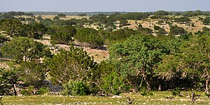
The landscape of the plateau is mostly savanna scattered with trees. It mostly lacks deep soil suitable for farming, though the soil type is fertile mollisol, so some cotton, grain sorghum, and oats are grown. For the most part, though, the thin soil and rough terrain areas are primarily grazing regions, with cattle, sheep, and goats (Angora and meat types) predominant.[4] Several rivers cross the region, which generally flow to the south and east through the Texas Hill Country toward the Gulf of Mexico; springs occur (in wet years), but permanent surface water supplies are sparse throughout the area, except for man-made reservoirs. The area is well drained; rainwater flows into the Edwards Aquifer recharge zone at the south of the plateau to feed rivers to the south. Rainfall varies from 15 to 33 inches per year, typically, from northwest to southeast, and the area has a moderate temperature and a reasonably long growing season.
Flora
Trees of the savanna include
Fauna
Caves of the Edwards Plateau are important habitats for wildlife and for many endemic species. The area is home to some of the largest colonies of bats in the world, including millions of Mexican free-tailed bats. The largest colony of these inhabits Bracken Cave near San Antonio, while the Congress Avenue Bridge in Austin is the summer home for over half a million (they winter in Mexico) and is the largest bat colony anywhere in an urban area. The Edwards Plateau is home to at least 14 endemic freshwater fishes, including two subterranean species of catfish[6] and 13 fish species considered to be spring-associated.[7] Mechanisms for spring association of fishes is not fully understood, but thought to mediated by water temperature.[8] The large numbers of reptiles and birds also include breeding populations of the Texan endemic golden-cheeked warbler (Setophaga chrysoparia).
Much of the natural habitat of the plateau has been converted to residential development, especially around Austin and San Antonio in the eastern part of the plateau. Further alteration to the savanna has incurred though the encroachment of shrubs now that grassland fires are carefully controlled. Small areas of intact habitat remain in protected areas such as the Balcones Canyonlands National Wildlife Refuge and Lost Maples State Natural Area. Another important area for wildlife is Fort Cavazos military base.[9]
Human history

Earliest human settlement of this area was by Native Americans.[10] First it was used and wandered about by
Counties in the Edwards Plateau
According to the Texas Parks and Wildlife Department, all or portions of these 41 counties comprise the Edwards Plateau geographic region:[11]
The Texas Water Development Board, a state government agency, includes additional counties all or partly in the Edwards Plateau area:[12]
A map showing the counties is provided by Texas Parks and Wildlife Department for the Edwards Plateau Ecoregion.[13] The ecoregion is somewhat larger than the geographic region, as the map from Texas Parks And Wildlife includes additional counties that are listed by the Texas Water Development Board, notably the isolated area of Edwards Plateau in Taylor, Runnels, and Nolan Counties that is separated from the main region.
Edwards Plateau gallery
-
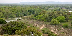
 San Saba River near Sloan, San Saba County (9 May 2014)
 -
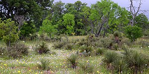
 Wildflowers on ranchland, State Highway 965, Llano County (13 April 2012)
 -
 Llano River from County Road 320, Kimble County (17 April 2015)
 -
 Texas cooter (Trachemys scripta), Colorado River, Travis County (12 April 2012)
 -
 The Guadalupe River in Kerr County (8 May 2014)
 -
 Ranchland with Texas bluebonnets (Lupinus texensis) in western Kerr County (17 April 2015)
 -
 Bald cypress (Taxodium distichum) growing on the Guadalupe River, Kerr County (14 April 2012)
 -
 Ranchland in the Edwards Plateau, Mason County (17 April 2015)
 -
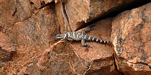 Crevice spiny lizard (Sceloporus poinsettii), Mason County, Texas, US (9 May 2014)
 -
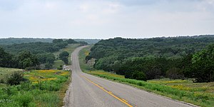 Highway 187 in the Edwards Plateau, Bandera County, Texas, US (14 April 2012)
 -
 Limestone bluff, typical of the Edwards Plateau, Highway 336, Real County (14 Apr 2012)
 -
 Ranchland seen from Highway 336, Real County (14 April 2012)
 -
 Scarlet penstemon (Penstemon triflorus), endemic to the Edwards Plateau, Edwards County (18 April 2015)
 -
 Ranch road in southern Edwards County (18 April 2015).
 -
 Cedar Creek, Edwards County (18 April 2015)
.jpg)
.jpg)
.jpg)
_and_red-eared_slider_(Trachemys_scripta),_Colorado_River,_Travis_County,_Texas,_USA_(12_April_2012).jpg)
.jpg)
_in_western_Kerr_County,_Texas,_USA_(17_April_2015).jpg)
_growing_on_the_Guadalupe_River,_Kerr_County,_Texas,_USA_(14_April_2012).jpg)
.jpg)
,_Mason_County,_Texas,_USA_(9_May_2014).jpg)
.jpg)
.jpg)
.jpg)
,_endemic_to_Edwards_Plateau,_Edwards_County,_Texas,_USA_(18_April_2015).jpg)
.jpg)
.jpg)
See also
- Balcones Canyonlands National Wildlife Refuge
- Colorado River (Texas)
- Mount Bonnell
- List of ecoregions in the United States (EPA)
- List of ecoregions in the United States (WWF)
References
- ^ a b c d
Hoekstra, J. M.; Molnar, J. L.; Jennings, M.; Revenga, C.; Spalding, M. D.; Boucher, T. M.; Robertson, J. C.; Heibel, T. J.; Ellison, K. (2010). Molnar, J. L. (ed.). The Atlas of Global Conservation: Changes, Challenges, and Opportunities to Make a Difference. ISBN 978-0-520-26256-0.
- ^ McCrain, James. "Edwards County". TSHA.
- ^ Demarest, D. "Edwards Plateau". Partners in Flight. Archived from the original on May 21, 2013. Retrieved September 2, 2014.
- ^ Johnson, E. H. "Edwards Plateau". Handbook of Texas Online. Retrieved March 12, 2009.
- ^ Hill, Robert T. (1891). "A brief description of the Cretaceous rocks of Texas and their economic uses". In E. T. Dumble (ed.). First Annual Report of the Geological Survey of Texas, 1889. Austin: State Printing Office. p. 134. Archived from the original on June 21, 2010. Retrieved March 21, 2010.
- ISSN 1099-0755.
- ISSN 2150-8925.
- PMID 30631643.
- ^ "Edwards Plateau". Terrestrial Ecoregions. World Wildlife Fund.
- ISBN 978-0-292-79156-5
- ^ Texas Parks and Wildlife http://www.tpwd.state.tx.us/huntwild/wild/birding/pif/assist/pif_regions/region_7.phtml
- ^ Mace, Robert. "Aquifers of the Edwards Plateau" (PDF). Texas Water Development Board. Retrieved October 11, 2020.
- ^ "Ecoregions of Texas" (PDF). Texas Parks And Wildlife. Retrieved October 12, 2020.
External links
- Johnson, E. H. (June 12, 2010). "Edwards Plateau". TSHA Handbook of Texas Online. Texas State Historical Association.
- "Plateaus and Canyonlands". Texas Beyond History. University of Texas at Austin.
- Texas counties map showing the ecoregion
| International | |
|---|---|
| National | |