1930 San Zenón hurricane
 Surface weather analysis of the hurricane just before landfall in the Dominican Republic on September 3 | |
| Meteorological history | |
|---|---|
| Formed | August 29, 1930 |
| Dissipated | September 17, 1930 |
| Category 4 major hurricane | |
| 1-minute sustained (SSHWS/NWS) | |
| Highest winds | 155 mph (250 km/h) |
| Lowest pressure | 933 mbar (hPa); 27.55 inHg |
| Overall effects | |
| Fatalities | 2,000–8,000 |
| Damage | $50 million (1930 USD) |
| Areas affected | Dominican Republic, Haiti, Cuba, Florida, North Carolina |
| IBTrACS | |
Part of the 1930 Atlantic hurricane season | |
The 1930 Dominican Republic hurricane, also known as Hurricane San Zenón, was a small but intense and deadly
, with less severe effects.Meteorological history

Tropical storm (39–73 mph, 63–118 km/h)
Category 1 (74–95 mph, 119–153 km/h)
Category 2 (96–110 mph, 154–177 km/h)
Category 3 (111–129 mph, 178–208 km/h)
Category 4 (130–156 mph, 209–251 km/h)
Category 5 (≥157 mph, ≥252 km/h)
Unknown
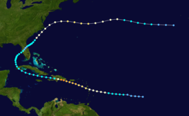
The system is estimated to have formed on August 29 about halfway between the Lesser Antilles and the
After passing over or near Dominica, the hurricane entered the
The mountainous terrain of Hispaniola rapidly weakened the hurricane, and by about 12 hours after moving ashore the winds decreased to tropical storm status. It quickly emerged into the Windward Passage and moved westward to the south of the Cuban coastline. On September 6 the storm crossed western Cuba before recurving northeastward into the Gulf of Mexico with winds of 40 mph (64 km/h). It strengthened slightly, moving ashore near Tampa, Florida, with 45 mph (72 km/h) winds. While crossing the state, it weakened to tropical depression status, although it re-intensified after moving into the western Atlantic Ocean. By September 12, it again attained hurricane status to the southeast of the Carolinas. After brushing the Outer Banks of North Carolina with winds of 70 mph (110 km/h), the hurricane turned eastward and reached a secondary peak intensity of 100 mph (160 km/h) to the north of Bermuda. It gradually weakened, deteriorating to tropical storm status on September 16 and dissipating the next day to the west of the Azores. The remnants merged with a system that later affected the Azores and Ireland.[1]
Impact
Winds of 80 to 100 mph (130 to 160 km/h) were reported on Dominica, with winds of hurricane-force winds reported across the Lesser Antilles.[2] The hurricane wrecked crops across the island and destroyed every ship at the harbor, killing two people.[4] Rough seas also occurred along the coast of Saint Kitts, and a ship recorded a pressure of 969 mbar (28.6 inHg) near the island.[5]
In southern Puerto Rico, the winds reached less than hurricane force,[1] which caused minor to moderate damage to plantations. Rainfall across the island was dispersed unusually; the maximum amount on the island was over 6 in (150 mm) in Cabo Rojo on the southwestern portion of the island, while the minimum amount was under 1 in (25 mm) at a location in the center of the southern coastline. Rainfall reached over 2 in (51 mm) along the northern coast, with totals varying from 1 to 4 in (25 to 102 mm) in the mountainous interior. The precipitation was considered generally beneficial, due to previously dry conditions across the island.[2]
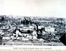
On September 3 the storm was a Category 4 when it struck the
Minor effects were reported away from the coast; the mountainous terrain of
Aftermath

Relief work in the
See also
- Hurricane David (1979) – hit the Dominican Republic at Category 5 intensity
- Effects of Hurricane Georges in the Dominican Republic (1988)
- Hurricanes in Hispaniola
- List of Category 4 Atlantic hurricanes
- List of Cuba hurricanes
- List of Florida hurricanes (1900–1949)
References
- ^ a b c d e Chris Landsea; et al. (2010). "Documentation of Atlantic Tropical Cyclones Changes in HURDAT". Hurricane Research Division. Archived from the original on 28 June 2011. Retrieved 2011-07-31.
- ^ a b c d e f g h F. Eugene Hartwell (1930). "The Santo Domingo Hurricane of September 1 to 5, 1930" (PDF). Weather Bureau Office in San Juan, Puerto Rico. Retrieved 2007-04-04.
- ^ "STEAMER OUTRIDES STOrm's FULL FURY; Caught in Vortex of Hurricane, Coamo Tilts Perilously as Gale Strips Decks". The New York Times. 5 September 1930.
- ^ Staff Writer (1930-09-06). "Two Dead in Dominica". The Milwaukee Journal. Associated Press. Retrieved 2011-07-31.[permanent dead link]
- ^ "First Caribbean Hurricane of the Season Reported". The Daily Gleaner. Vol. 96, no. 175. Kingston, Jamaica. The Daily Gleaner. 1930-09-02. p. 1 – via NewspaperArchive.com.
- ^ "Atlantic hurricane best track (HURDAT version 2)" (Database). United States National Hurricane Center. April 5, 2023. Retrieved April 18, 2024.
 This article incorporates text from this source, which is in the public domain.
- ISBN 978-1-4067-4641-9.
- ^ a b c d "Santo Doming Leveled by Hurricane; Believe 900 Dead, Injured in Hurricane". Ironwood Daily Globe. Vol. 11, no. 245. Ironwood, Michigan. Associated Press. 1930-09-04. p. 1. Retrieved 2019-07-03 – via Newspapers.com.
- ^ "Storm Dead at 300". Marshfield News-Herald. Vol. 10, no. 145. Marshfield, Wisconsin. Associated Press. 1930-09-04. Retrieved 2019-07-03 – via Newspapers.com.
- ^ a b c d Various (1930). "Appendices to the Santo Domingo Hurricane of September 1 to 5, 1930" (PDF). Weather Bureau Office. Retrieved 2007-04-12.
- NOAA. Archivedfrom the original on 26 May 2007. Retrieved 2007-04-12.
