
Banjul
Banjul
ߓߊ߲߬ߖߎߟ Banjul 𞤄𞤢𞤲𞥆𞤶𞤵𞤤𞤵 Bannjulu | |
|---|---|
Banjul airport, Arch 22 | |
|
UTC±00:00 (GMT) | |
| HDI (2017) | 0.552[1] medium |
| Website | www |
Banjul (UK: /bænˈdʒuːl/,[2][3] US: /ˈbɑːndʒuːl/),[2][3][4][5] officially the City of Banjul, is the capital of The Gambia. It is the centre of the eponymous administrative division which is home to an estimated 400,000 residents, making it The Gambia's largest and most densely populated metropolitan area. Banjul is located on St Mary's Island (Banjul Island), where the Gambia River enters the Atlantic Ocean.
The population of the city proper is 31,301, with the Greater Banjul Area, which includes the City of Banjul and the Kanifing Municipal Council, at a population of 413,397 (2013 census).[6] The island is connected to the mainland to the west and the rest of Greater Banjul Area via bridges. There are also ferries linking Banjul to the mainland at the other side of the river.
From the 19th century until 24 April 1973, the city was known as Bathurst.[7]
Etymology
There are several etymologies for 'Banjul.' One traditional history recounts that Bandjougou, son of Barafin, came to the island after fleeing the attacks of
History


In 1651, Banjul was leased by
On 23 April 1816,
Within a few years of its establishment the town started attracting migrants. Its population consisted of Africans of various origins, Levantines (Syrians, Lebanese) as well as Europeans (English, French, Portuguese). A majority of the population was Muslim but there was a significant Christian minority, including the Aku inhabitants. The majority of the Africans consisted of Wolof people, whose population rose from 829 in 1881 to 3,666 in 1901 and then 10,130 in 1944. They had mainly hailed from Gorée and Saint-Louis. The Mandinka were the second largest African group, followed by the Jola as well as the Fula. The Serer people make up 3.5% of the country's demographics.[13] Islamic schools called dara were founded in Bathurst from its early years, resulting in the foundation of the first Muslim court in 1905, in addition to the increasingly more sophisticated British legal framework.[10]
Bathurst was officially declared the capital of the Protectorate of the Gambia in 1889, leading to an increase in population. Through the 20th century, it became an even greater attraction for Gambians due to the availability of jobs fuelled by British colonial activities as well as social activities such as cinemas. Young men from rural farming villages would move to Bathurst to work at the Public Works Department (established in 1922) or docks. The town was an important Allied naval and air hub during World War II, resulting in an increase in population from 14,370 in 1931 to 21,154 in 1944.[10]
After independence, the town's name was changed to Banjul in 1973.[11] On 22 July 1994, Banjul was the scene of a bloodless military coup d'état in which President Sir Dawda Jawara was overthrown and replaced by Yahya Jammeh. To commemorate this event, Arch 22 was built as an entrance portal to the capital. The gate is 35 metres tall and stands at the centre of an open square. It houses a textile museum.
Climate
Banjul features hot weather year round. Under the
According to a Gambian government minister, Banjul is at risk of submerging under water by a metre rise in sea levels as a result of climate change and global warming.[14]
| Climate data for Banjul (1991-2020) | |||||||||||||
|---|---|---|---|---|---|---|---|---|---|---|---|---|---|
| Month | Jan | Feb | Mar | Apr | May | Jun | Jul | Aug | Sep | Oct | Nov | Dec | Year |
| Mean daily maximum °C (°F) | 32.5 (90.5) |
33.2 (91.8) |
32.9 (91.2) |
31.8 (89.2) |
31.6 (88.9) |
32.3 (90.1) |
31.8 (89.2) |
31.6 (88.9) |
32.1 (89.8) |
33.6 (92.5) |
34.0 (93.2) |
33.1 (91.6) |
32.5 (90.5) |
| Daily mean °C (°F) | 25.3 (77.5) |
25.9 (78.6) |
26.3 (79.3) |
26.1 (79.0) |
26.5 (79.7) |
27.5 (81.5) |
27.7 (81.9) |
27.7 (81.9) |
27.9 (82.2) |
28.9 (84.0) |
28.4 (83.1) |
26.6 (79.9) |
27.1 (80.8) |
| Mean daily minimum °C (°F) | 18.3 (64.9) |
18.7 (65.7) |
19.9 (67.8) |
20.3 (68.5) |
21.2 (70.2) |
22.7 (72.9) |
23.7 (74.7) |
23.8 (74.8) |
23.7 (74.7) |
24.1 (75.4) |
22.7 (72.9) |
20.1 (68.2) |
21.6 (70.9) |
| Average precipitation mm (inches) | 0.7 (0.03) |
0.9 (0.04) |
0.0 (0.0) |
0.0 (0.0) |
2.5 (0.10) |
44.7 (1.76) |
174.8 (6.88) |
303.6 (11.95) |
244.1 (9.61) |
66.4 (2.61) |
1.3 (0.05) |
0.2 (0.01) |
839.2 (33.04) |
| Average precipitation days (≥ 1.0 mm) | 0.1 | 0.2 | 0.0 | 0.0 | 0.1 | 3.3 | 11.4 | 15.6 | 13.7 | 4.4 | 0.1 | 0.1 | 49.0 |
| Average relative humidity (%)
|
47 | 47 | 50 | 58 | 67 | 73 | 81 | 85 | 84 | 80 | 69 | 55 | 67 |
| Mean monthly sunshine hours | 207.7 | 237.3 | 266.6 | 252.0 | 229.4 | 201.0 | 182.9 | 189.1 | 183.0 | 217.0 | 246.0 | 210.8 | 2,622.8 |
| Mean daily sunshine hours | 6.7 | 8.4 | 8.6 | 8.4 | 7.4 | 6.7 | 5.9 | 6.1 | 6.1 | 7.0 | 8.2 | 6.8 | 7.2 |
| Source 1: World Meteorological Organization[15] | |||||||||||||
| Source 2: Deutscher Wetterdienst (humidity and sun)[16] | |||||||||||||
| Jan | Feb | Mar | Apr | May | Jun | Jul | Aug | Sep | Oct | Nov | Dec | Year |
|---|---|---|---|---|---|---|---|---|---|---|---|---|
| 22 °C (72 °F) | 21 °C (70 °F) | 21 °C (70 °F) | 22 °C (72 °F) | 24 °C (75 °F) | 26 °C (79 °F) | 27 °C (81 °F) | 27 °C (81 °F) | 27 °C (81 °F) | 27 °C (81 °F) | 27 °C (81 °F) | 24 °C (75 °F) | 25 °C (77 °F) |
Climate change
A 2019 paper published in PLOS One estimated that under Representative Concentration Pathway 4.5, a "moderate" scenario of climate change where global warming reaches ~2.5–3 °C (4.5–5.4 °F) by 2100, the climate of Banjul in the year 2050 would most closely resemble the current climate of Bamako in Mali. The annual temperature would increase by 2 °C (3.6 °F), and the temperature of the warmest month by 3.3 °C (5.9 °F), while the temperature of the coldest month would actually decrease by 1.2 °C (2.2 °F).[17][18] According to Climate Action Tracker, the current warming trajectory appears consistent with 2.7 °C (4.9 °F), which closely matches RCP 4.5.[19]
Districts

Banjul Division (Greater Banjul Area) is divided into two districts:
- Banjul
- Kanifing
Economy
Banjul is the country's economic and administrative centre and includes the Central Bank of the Gambia. Peanut processing is the country's principal industry, but beeswax, palm wood, palm oil, and skins and hides are also shipped from the port of Banjul.[20]
Banjul is also the home of the Gambia Technical Training Institute. GTTI is engaged in a partnership with non-profit organization Power Up Gambia to develop a solar energy training program.
Transport
The primary method of reaching the city by land is by road. A highway connects Banjul to
-
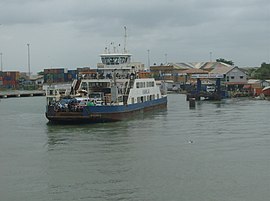 Banjul Ferry

Culture
Attractions in the city include the
Sport
Banjul is the destination of the Plymouth-Banjul Challenge, a charity road rally.
Education
The University of the Gambia was founded in 1999.
International schools
- Banjul American Embassy School
Places of worship
The
Notable people
- Gambino Akuboy (born 1985), singer & songwriter, actor and screenwriter
- Ebrima Darboe (Born 2001), football player
- Ibrahim Muhammadu Garba-Jahumpa(1912-1994), trade union leader and politician
See also
- Divisions of the Gambia
- Districts of the Gambia
Bibliography
- Pierre Gomez; Hassoum Ceesay, eds. (2018). A Geocritical Representation of Banjul (Bathurst): 1816–2016. Global Hands Publishing.
- Matthew James Park, Heart of Banjul: The History of Banjul, The Gambia, 1816-1965 Archived 2020-07-26 at the Wayback Machine. PhD dissertation, Michigan State University, 2016.
- ISBN 0415234794.
External links
- A History of Banjul, PhD thesis Archived 2023-02-23 at the Wayback Machine
References
- ^ "Sub-national HDI – Area Database – Global Data Lab". hdi.globaldatalab.org. Retrieved 2018-09-13.
- ^ a b "Banjul". Collins English Dictionary. HarperCollins. Archived from the original on April 12, 2019. Retrieved April 12, 2019.
- ^ a b "Banjul". Archived from the original on 12 April 2019. (US) and "Banjul". Lexico UK English Dictionary. Oxford University Press. Archived from the original on 22 March 2020.
- ^ "Banjul". The American Heritage Dictionary of the English Language (5th ed.). HarperCollins. Retrieved April 12, 2019.
- ^ "Banjul". Merriam-Webster.com Dictionary. Retrieved April 12, 2019.
- ^ "The Gambia 2013 Population and Housing Census Preliminary Results" (PDF). Gambia Bureau of Statistics. Archived from the original (PDF) on 2018-07-13. Retrieved 2017-12-07.
- ^ "Gambia: The Post-Colonial Period, Part III". Gambia. Retrieved 11 December 2022.
- ^ Mane, Daouda (2021). "La Question des Origines et de l'Emergence de l'Etat de Kaabu". In Fall, Mamadou; Fall, Rokhaya; Mane, Mamadou (eds.). Bipolarisation du Senegal du XVIe - XVIIe siecle (in French). Dakar: HGS Editions. p. 251.
- ISBN 978-0-8108-6260-9.
- ^ ISBN 9781611862669.
- ^ a b "History of Banjul". Accessgambia.com. Retrieved 2012-10-29.
- ^ ISBN 978-0-8108-6260-9.
- ^ CIA World Fact: Gambia [1] (retrieved 13 April 2024)
- ^ "Gambia: Banjul Risks Sinking As Sea Level Rises", AllAfrica, Africa, 13 August 2012, retrieved 11 October 2012 – via The Daily Observer
- ^ "World Meteorological Organization Climate Normals for 1991-2020 — Banjul". National Oceanic and Atmospheric Administration. Retrieved January 4, 2024.
- ^ a b "Klimatafel von Banjul-Yundum (Flugh.) / Gambia" (PDF). Baseline climate means (1961–1990) from stations all over the world (in German). Deutscher Wetterdienst. Retrieved 12 September 2022.
- PMID 31291249.
- ^ "Cities of the future: visualizing climate change to inspire action". Current vs. future cities. Retrieved 8 January 2023.
- ^ "The CAT Thermometer". Retrieved 8 January 2023.
- ^ "Gambia, The". State.gov. 2012-07-03. Retrieved 2012-10-29.
- ^ "Denton Bridge bridge, Banjul, Gambia". Gambia. Retrieved 2018-02-12.
- ^ "Virtual Tourist, The Gambia Transportation". Archived from the original on 2015-09-08. Retrieved 2014-05-18.
- ^ "Banjul Travel information". HappyTellus. 2009-06-14. Archived from the original on 2012-10-04. Retrieved 2012-10-29.
- Agency for French Teaching Abroad(AEFE). Retrieved 11 June 2023.
- ^ J. Gordon Melton, Martin Baumann, Religions of the World: A Comprehensive Encyclopedia of Beliefs and Practices, ABC-CLIO, USA, 2010, p. 1172
| Local Government Areas | |||||||||||||
|---|---|---|---|---|---|---|---|---|---|---|---|---|---|
| National capital, Divisions and Districts |
| ||||||||||||