
Brzeg
Brzeg | |
|---|---|
 .jpg)  _ID_609764.jpg)
| |
|
UTC+2 (CEST) | |
| Postal code | 49-300 |
| Vehicle registration | OB |
| National roads | |
| Website | https://brzeg.pl |
Brzeg ([bʐɛk] ⓘ; Latin: Alta Ripa, German: Brieg, Silesian German: Brigg, Silesian: Brzeg, Brzyg, Czech: Břeh) is a town in southwestern Poland with 34,778 inhabitants (December 2021)[2] and the capital of Brzeg County. It is situated in Silesia in the Opole Voivodeship on the left bank of the Oder river.
The town of Brzeg was first mentioned as a trading and fishing settlement within fragmented
Etymology
In older documents, Brzeg was referred to as Civitas Altae Ripae, meaning 'city on the high banks' of the Oder River; its name is derived from Polish brzeg 'shore'.
: Wissokembreghe; literally 'high bank').A native or resident of Brzeg is known as a brzeżan, brzeżanin (male), brzeżanka (female), brzeżanie and brzeżaninie (plural).
History
Prehistory

The locality in and around present-day Brzeg has been settled by people since the
The time period of 1300–700 BC bears the existence of the Lusatian culture of the late Bronze Age and the early Iron Age. The culture settled in the region and in large continued to develop agriculture and the domestication of farm animals. The natural economy of the culture was based on weaving, pottery and metal works. The Lusatian culture's populace that inhabited the Brzeg Lands was identified by archaeological excavations, revealing 17 individual localities, including 3 hamlets and 8 burial sites, namely a fortified wooden settlement in Rybna and an open-pit crematory in Pisarzowice (with 30 discovered burial sites).[need quotation to verify]
To follow the
Early Middle Ages
The period of AD 500–1000 saw the establishment of the early
Between the ninth and early-tenth century, the Brzeg Lands, together with all of Silesia, were part of Great Moravia until its demise in AD 906, after which, until 990 the region was under the rule of the Premyslids.
Medieval Poland
Around 990,

The most favourable area for the settlement of Brzeg is located between the Castle Square (Plac Zamkowy), with elevated ground extending south-east towards the Square of the
Some two hundred m south-west from the
Prior to Brzeg receiving its

The town received German town law in 1250 from the
From 1311 to 1675 Brzeg was the capital of a
Early modern period

At the beginning of the 16th century there were two schools in Brzeg, a collegiate and a municipal school, both influenced by the scientific, cultural and literary currents of the
The town continued to flourish under the reign of Duke George II. George II maintained close contacts with the Polish–Lithuanian Commonwealth and its nobility, and rebuilt the Ducal Castle in Renaissance style, built the Renaissance town hall, established a new mausoleum of the Piast dukes and built a new gymnasium, opened in 1569.[18] The libraries of the old schools were merged into the newly named Piast Library.[19] The gymnasium became popular among Polish nobility, whose children were often educated there.[20] Among the graduates were Polish Royal secretary and poet Joachim Bielski and reformer Samuel Hartlib, co-founder of the Royal Society of London.[21]
In 1595 Brzeg was again fortified by
Late modern and contemporary

In 1537 Duke
During
Traditional Garrison Town

From the late 19th century the then German town of Brieg had expanded into a traditional military
At the end of World War I the garrison barracks at Brieg remained for some years after without a stationed military regiment.
Towards the end of World War II, on 6 February 1945, the Soviet army captured Brzeg, which resulted in moderate destruction of the town's buildings and infrastructure.[3] After Germany's defeat in the war, Brzeg became part of Poland. Since 1950 the reconstructed town has been a part of the Opole Voivodeship.
History of the Jewish population
As the town was situated on the commercial route to
With the decline of Wrocław as a trade center, the Jews of Brieg became little more than an isolated community; and in modern times they shared the lot of the other Silesian Jews. They carried on insignificant trade operations as a rule. The conquest of Silesia by Frederick the Great brought but slight change in their condition.
A
Geography
Status
The shape of the town, including its neighbouring osiedla, is comparable to that of a deformed rectangle, elongated 3.54 kilometres (2.20 miles) north-south and 4.10 kilometres (2.55 miles) west-east. The area of the town, including the village of Rataje, which was incorporated into Brzeg on January 1, 1973, is some 16 km2 (6.2 sq mi). In comparison to Opole, with a total area of 48 km2 (19 sq mi); Nysa's 29 km2 (11 sq mi) and Kędzierzyn-Koźle's 23 km2 (8.9 sq mi); Brzeg is ranked fourth in the Opole Voivodeship by both population and area.[29]
Topography

Brzeg, as the regional capital of
The Brzeg Plain was formed by the
}}Settlement and trade
The settlement of Brzeg, historically located in the regional unit of
Brzeg's geographical position between two trade routes, running from west to east (Legnica–Opole) and north to south (Gniezno–Nysa) and further on into the Kingdom of Bohemia, additionally stimulated the town's demographic and economic expansion. Presently, Brzeg remains located between the European route E67 and E40.
Environment

Brzeg has five
The largest parkland in Brzeg, located in the south-west of the town is the Park of Juliusz Peppel (Park im. Juliusza Peppela) and formerly Liberty Park (Park Wolności) having a total area of 68.8 ha.
Demography
History
Since the


Breakdown of population origin of Brzeg in 1950:
| Population origin | Population no. | Percentage (%) |
|---|---|---|
| Total population | 12,771 | 100.0 |
| Local population | 824 | 6.5 |
| Migrant population | 11,947 | 93.5 |
Breakdown of migrant population origin of Brzeg in 1950:[46]
| Population origin | Population no. | Percentage (%) |
|---|---|---|
| Warsaw | 469 | 3.9 |
| Warsaw Voivodeship | 365 | 3.0 |
| Bydgoszcz Voivodeship | 289 | 2.4 |
| Poznań Voivodeship | 533 | 4.5 |
| Łódź | 75 | 0.6 |
| Łódź Voivodeship | 529 | 4.4 |
| Kielce Voivodeship | 749 | 6.3 |
| Lublin Voivodeship | 387 | 3.2 |
| Białystok Voivodeship | 144 | 1.2 |
| Katowice Voivodeship | 747 | 6.3 |
| Kraków Voivodeship | 911 | 7.6 |
| Soviet Union | 5,144 | 43.1 |
| Other countries | 200 | 1.7 |
| Remaining | 1,405 | 11.8 |
Population change:[2]
| Year | Population | Year | Population |
|---|---|---|---|
| 2002 | 38 841 |
2003 | 38 781 |
| 2004 | 38 550 |
2005 | 38 379 |
| 2006 | 38 163 |
2007 | 37 842 |
| 2008 | 37 625 |
2009 | 37 609 |
| 2010 | 37 346 |
2011 | 37 329 |
| 2012 | 37 261 |
2013 | 36 980 |
| 2014 | 36 675 |
2015 | 36 469 |
| 2016 | 36 381 |
2017 | 36 110 |
| 2018 | 35 930 |
2019 | 35 709 |
| 2020 | 35 226 |
2021 | 34 778 |
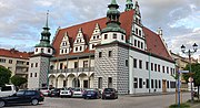
Main sights
_ID_609748.jpg)

- The Renaissance Brzeg Town Hall (Rynek), surrounded by thirteenth-century townhouses.
- Wawel. The castle-complex includes the Chapel of St. Jadwiga of Poland.
- St. Nicholas's Church(Gothic architectural style).
- Holy Cross Church(on old castle square), (Baroque architectural style).
- St. Jadwiga's Church, located by the castle.
- St. Luke's Church, a church built in the Neoclassical architectural style.
- Saints Peter and Paul Church, a Franciscan church built in the thirteen-century.
- Christ's Resurrection Church, a garrison church built in the Baroque architectural style.
- Baroque figures of John of Nepomuk and Jude the Apostle from 1722, standing by the façade of the Holy Cross Church.
- Statue of the Holy Trinity (on old castle square), raised in 1731.
- Piast Gimnasium (Gimnazium Piastowskie) founded in 1569.
- Odrzańska Gate, part of the former fortifications; located in the Park Odrzański (Odranian Park).
- Water tower (Wieża ciśnień) by Rybacka Street (ul. Rybacka), from 1877.
- Residential townhouses:
- Rynek 19, Renaissance façade from 1621 (reconstruction).
- Chopina 1, Renaissance from 1597.
- Jabłkowa 5, Baroque townhouse from 1715.
- Jabłkowa 7, Empire architectural style from 1797.
- Old Garrison buildings (Stare Koszary) from the Frederick the Great colonisation period.
- Planty - remaining bastion fortifications around the medieval town. The fortifications were deconstructed in 1807, with the area transformed into the Planty Park.
- Synagogue from 1799.
- River Boat Station (Brzeg Marina) (on the east bank of the Oder), built in 2012.
Economy

Industry
Brzeg is the centre for industry and production in the Brzeg County. The town's industries include the production of agricultural machinery, electric engines, margarine and sugar production.[47]
The largest concentration of industry in Brzeg is located in the town's eastern quarter, south of the
All three industries are located between Ciepłownicza Street (ul. Ciepłownicza) and Składowa Street (ul. Składowa).Brzeg is also home to one of the largest confectionery companies in Poland, PWC Odra S.A. (founded in 1946). Presently, the firm is part of the joint-stock company Otmuchów Group.[51] The production plant is located by Starobrzeska Street (ul. Starobrzeska).
Tourism
As of 2015[update], Brzeg had the lowest number of foreign tourists in the Opole Voivodeship, with some 95% being national tourists. Per 1000 of the population, there are 1.60–3.89 available accommodations, which is behind nine of the eleven regional capitals (being at level with Kędzierzyn-Koźle) in the Opole Voivodeship, including Opole, with 3.90–5.89 tourist accommodations per 1000 of the population.[52]
Education

Brzeg has a total of 7,826 citizens in the potential education age group (3-24 year of age). The number of city dwellers in Brzeg that have completed
Some 22.4% of the population of the town of Brzeg (as of 2015[update]) has some sort of work-related further education (i.e.
Post-secondary education institutions:[58]
| Name | Address | Faculty no. | Student no. | Teacher no. | Website |
|---|---|---|---|---|---|
| Technikum No. 1 in Brzeg | Słowiańska 18 | 21 | 466 | – | – |
| Technikum No. 2 in Brzeg | Jana Pawła II 28 | 14 | 370 | – | – |
| I Liceum ogólnokształcące (Bolesław Chrobry) | Armii Krajowej 7 | 10 | 320 | 31 | Official Website |
| II Liceum ogólnokształcące (Zbigniew Herbert)
|
1 Maja 7 | 13 | 341 | 36 | Official Website |
| Zasadnicza Szkoła Zawodowa No. 3 (Książę Jerzy II Piast) | Kamienna 3 | 9 | 261 | – | Official Website |
| Technikum No. 3 (Książę Jerzy II Piast) | Kamienna 3 | 8 | 207 | – | Official Website |
| Państwowa Szkoła Muzyczna Level 1 (Józef Elsner) | Piastowska 18 | – | 161 | 20 | Official Website |
Public gymnasium (secondary school) institutions:[59]
| Name | Address | Faculty no. | Student no. | Teacher no. | Website |
|---|---|---|---|---|---|
| Gymnasium No. 3 (Orlęta Lwowskie) | Bohaterów Monte Cassino 14 | 12 | 343 | 35 | Official Website |
| Gymnasium No. 2 | Poprzeczna 16 | 12 | 317 | — | — |
| Gymnasium No. 1 (Józef Piłsudski) | Oławska 2 | 9 | 225 | 26 | Official Website |
| Gymnasium No. 4 | Lompy 1 | 6 | 142 | — | — |
Transport

Brzeg is located at the crossroads of the
Brzeg has well developed railway and bus transportation services. The
In 2013, a hospital helipad was opened by Mossora Street (ul. Mossora).[61]
Sports
- Sharp Torell Basket Ligain 2003/2004 season
Notable people
- C. de Bridia(born 1247), Minorite friar, wrote the Tartar Relation (de Bridia meaning "of Brzeg")
- Melchior Adam (ca.1575 in Grottkau – 1622), a German Calvinist literary historian.[62]
- hymnodist
- Georg Gebel the younger (1709–1753), Prussian general
- Leopold Wilhelm von Dobschütz (1763–1836), Prussian general
- philodorian.[63]
- Julius Müller (1801–1878), a German Protestant theologian.[64]
- philosopher
- Max Friedlaender (1852–1934), German musician and composer
- Oskar Moll (1875-1947), German painter
- Max Obal (1881–1949), German actor, screenwriter and film director
- Alfred Kurella (1895–1975), German SED functionary
- musicologist and conductor
- Auschwitzsurvivor
- Otto Thorbeck (1912–1976), German lawyer
- Kurt Masur (1927–2015), German musician and conductor[65]
- thracologist
- Adrian Tekliński (born 1989), Polish road and track cyclist
- Kamil Bednarek (born 1991), Polish reggae and dancehall musician and composer.
- Bartosz Białek (born 2001), Polish football player
Twin towns – sister cities
 Beroun, Czech Republic
 Bourg-en-Bresse, France
 Goslar, Germany
Gallery
-
 Most characteristic building of Brzeg, Silesian Piasts Castle
 -
 Northern side of the castle's courtyard
 -
 Southern side of the castle
 -
 Juliusz Peppel Park, the largest public park in town
 -
 Long Street, main high street
 -
 Marina by the River Oder
 -
 Town square and tower
 -
 Town Hall
 -
 St. Nicholas Church and Brzeski Dom Kultury cultural centre
 -
 Interior of the church
 -
 Holy Cross Church
 -
 Interior of the Holy Cross Church
 -
 Church ceiling


.jpg)


.jpg)

.jpg)


References
- ^ "Historia miejscowości - Informacje o mieście - Brzeg - Wirtualny Sztetl". www.sztetl.org.pl (in Polish). Retrieved 26 August 2017.
- ^ a b c "Local Data Bank". Statistics Poland. Retrieved 2022-06-02. Data for territorial unit 1601011.
- ^ a b "Local history - Information about the town - Brzeg - Virtual Shtetl". Archived from the original on 7 February 2017. Retrieved 6 February 2017.
- ^ Długosz, Jan (1867). Historiae Polonicae libri XII. Kraków.
{{cite book}}: CS1 maint: location missing publisher (link) - ^ Surowiecki, Piotr. "Muzeum na Zamku w Brzegu". www.psur.pl. Retrieved 4 February 2017.
- ^ Dziewulski, W. (1954). Brzeg przedlokacyjny, Śląski Kwartalnik Historyczny Sobótka.
- ^ Żabiński, Ryszard. "Zobacz grodziska ryczyńskie". Gazetawroclawska.pl (in Polish). Retrieved 4 February 2017.
- ^ "W ryczyńskim lesie". Historia magistra vitae (in Polish). Retrieved 4 February 2017.
- ^ "Gmina Oława". www.gminaolawa.pl. Archived from the original on 5 February 2017. Retrieved 4 February 2017.
- ^ "Historia Brzegu". pit.brzeg.pl. Retrieved 4 February 2017.
- ^ a b c d Kostrzewski, J (1970). Pradzieje Śląska. Wrocław.
{{cite book}}: CS1 maint: location missing publisher (link) - ^ "Topographical map denoing the agricultural land and plots of Rataje". portal.gison.pl.
- ^ "Po Ziemi Brzeskiej - Historia / Timeline". www.poziemibrzeskiej.strefa.pl. Retrieved 5 February 2017.
- ^ a b Dziewulski, Władysław; Stelmach, Jerzy; Łuszczewska, Barbara; Dziubowa, Maria; Wilk, Barbara (1975). Brzeg. Opole: Instytut Śląski w Opolu. pp. 9–11.
- ^ Gustav Tzschoppe, Gustav Stenzel (1832). Urkundensammlung zur Geschichte des Ursprungs der Städte. F. Perthes, 1832. Retrieved 16 April 2017.
- Zakład Narodowy im. Ossolińskich, Wydawnictwo Polskiej Akademii Nauk: 177.
- ^ Barycz, pp. 178–179
- ^ Barycz, pp. 179, 181
- ^ Barycz, p. 179
- ^ Barycz, p. 181
- ^ Barycz, pp. 182, 185
- ^ a b Merriam Webster's Geographical Dictionary, Third Edition, p. 180
- Zakład Narodowy im. Ossolińskich, Wydawnictwo Polskiej Akademii Nauk: 371.
- ^ "Zuchthaus Brieg". Bundesarchiv.de (in German). Retrieved 10 December 2023.
- ^ Konieczny, p. 377
- ^ a b Book Title: Das 4. Schlesische Infanterie-Regiment Nr. 157. Nach den amtlichen Kriegstagebüchern bearbeitet (English: The 4th Silesian Infantry Regiment No. 157. Edited according to official war diaries.), Authors: Tiede (Generalleutnant), Himer (Hauptmann) and Röhricht (Oberleutnant), 1922, Publisher: Stalling, Oldenburg, Germany, in German.
- ^ a b c Book Title: Das 4. Schlesische Infanterie-Regiment Nr. 157 im Frieden und im Kriege 1897-1919 (English: The 4th Silesian Infantry Regiment No. 157 in peacetime and in wartime 1897-1919), Author: Hans Guhr (Generalmajor), Paul Tiede (General der Infanterie), 1934, Publisher: Bernhard Sporn, Zeulenroda (Thüringen), Germany, in German.
- ^ "Zwangsarbeitslager für Juden Brieg". Bundesarchiv.de (in German). Retrieved 10 December 2023.
- ^ "Po Ziemi Brzeskiej - Odra". www.poziemibrzeskiej.strefa.pl. Retrieved 3 February 2017.
- ^ "Wyborcza.pl". wroclaw.wyborcza.pl. Retrieved 3 February 2017.
- ^ Jóźwiak, Radio Elka, Tomek. "Żegluga rzeczna zamarła, ryby padają, zostały kaczki i bobry. Odra wysycha w oczach". miedziowe.pl - portal Radia Elka. Retrieved 3 February 2017.
{{cite web}}: CS1 maint: multiple names: authors list (link) - ^ "Forum Brzeg - Brzeskie wyspy". www.forumbrzeg.pl. Retrieved 3 February 2017.
- ^ Grodka, A. (1948). Monografia Odry. Poznań.
{{cite book}}: CS1 maint: location missing publisher (link) - ^ "LOKALNA GRUPA DZIAŁANIA STOWARZYSZENIE BRZESKA WIEŚ HISTORYCZNA" (PDF). www.brzeskawieshistoryczna.pl. Archived from the original (PDF) on 4 February 2017. Retrieved 3 February 2017.
- ^ [1] meteoblue.com
- ^ Czyżewski, J. (1948). Oblicze Ziem Odzyskanych: Krajobraz Niżu Śląskiego, Tom 1. Warszawa, Wrocław.
{{cite book}}: CS1 maint: location missing publisher (link) - ^ "Historia miasta". www.pkulczycki.wodip.opole.pl. Retrieved 3 February 2017.
- ^ "Historia miejscowości - Informacje o mieście - Brzeg - Wirtualny Sztetl". www.sztetl.org.pl (in Polish). Retrieved 3 February 2017.
- ^ "Gazeta Brzeska". www.gazetabrzeska.eu. Retrieved 1 February 2017.
- ^ "Burmistrz Peppel - zasłużony dla rozwoju miasta". Historia magistra vitae (in Polish). Retrieved 1 February 2017.
- ^ "Natura". Urząd Miasta w Brzegu (in Polish). Retrieved 1 February 2017.
- ^ "Parki miejskie". www.pkulczycki.wodip.opole.pl. Retrieved 1 February 2017.
- ]
- ^ Kosiński, L. (1960). Pochodzenie terytorialne ludności Ziem Zachodnich w 1950 r., "Dokumentacja Geograficzna".
- ^ "Główny Urząd Statystyczny / Portal Edukacyjny / Historia statystyki / Historia spisów powszechnych / Spisy ludności w latach 1943-1950". stat.gov.pl (in Polish). Retrieved 3 February 2017.
- ^ Narodowy Spis Powszechny z dnia 3 grudnia 1950 4. Struktura Zawodowa i demograficzna Polski. Województwo opolskie. Warsaw. 1954.
{{cite book}}: CS1 maint: location missing publisher (link) - ^ "Main Page". Grupa Otmuchów. Retrieved 5 March 2016.
- ^ "Bartling - The company". www.bartling-verpackungen.de. Retrieved 2 February 2017.
- ^ "Besel - electric motors, AC induction motors, industrial motors, brake motors, elektromotor, ie2 motor, ie3 motor, 3 phase motor, general purpose motors, high voltage motor, single phase motor, components, tools". site.cantonigroup.com. Archived from the original on 3 February 2017. Retrieved 2 February 2017.
- ^ "CIK Company". cikcar.pl. Retrieved 2 February 2017.
- ^ "Historia - PWC Odra S.A. - Spółki zależne - O grupie - Grupa Otmuchów". www.grupaotmuchow.pl (in Polish). Retrieved 9 November 2017.
- ^ "Turystyka w województwie opolskim". opole.stat.gov.pl (in Polish). Retrieved 4 February 2017.
- ^ "Brzeg". www.polskawliczbach.pl (in Polish). Retrieved 31 January 2017.
- ^ "Szkoły policealne". Urząd Miasta w Brzegu (in Polish). Retrieved 31 January 2017.
- ^ "Wydział Oświaty, Kultury i Kultury Fizycznej – Starostwo Powiatowe w Brzegu". brzeg-powiat.pl (in Polish). Retrieved 1 February 2017.
- ^ "Brzeg". www.polskawliczbach.pl (in Polish). Retrieved 31 January 2017.
- ^ www.ideo.pl, ideo -. "Główny Urząd Statystyczny". stat.gov.pl (in Polish). Retrieved 31 January 2017.
- ^ "Brzeg, post-secondary schools". www.polskawliczbach.pl (in Polish). Retrieved 1 February 2017.
- ^ "Brzeg". www.polskawliczbach.pl (in Polish). Retrieved 2 February 2017.
- ^ "Kolejne opóźnienia na budowie autostrady A4 na Podkarpaciu". Nowiny24. 2012-09-21. Retrieved 5 March 2016.
- ^ "Miejsca lądowania śmigłowców ratunkowych". IPR. Archived from the original on 4 March 2016. Retrieved 5 March 2016.
- ^ . Encyclopædia Britannica. Vol. 1 (11th ed.). 1911. p. 172.
- ^ . Encyclopædia Britannica. Vol. XVII (9th ed.). 1884.
- ^ . Encyclopædia Britannica. Vol. 18 (11th ed.). 1911.
- ^ "Polish town remembers famous conductor Kurt Masur". Radio Poland. Retrieved 21 December 2015.
- ^ "Miasta partnerskie". brzeg.pl (in Polish). Brzeg. Archived from the original on 2021-04-15. Retrieved 2020-03-04.
Bibliography of Jewish Encyclopedia
- Brann, Geschichte der Juden in Schlesien;
- Jahrbuch des Deutsch-Israelitischen Gemeindebundes
 This article incorporates text from a publication now in the public domain: Singer, Isidore; et al., eds. (1901–1906). The Jewish Encyclopedia. New York: Funk & Wagnalls.
 {{cite encyclopedia}}: Missing or empty|title=(help) ([2])
External links
- Forum Brzeg
- Official website
- Dziennik Brzeski
- Foto Brzeg
- Komornik Brzeg
- Jewish Community in Brzeg on Virtual Shtetl
| Urban gminas |
| _COA.svg) |
|---|---|---|
| Urban-rural gminas | ||
| Rural gminas | ||
| International | |
|---|---|
| National | |
| Geographic | |