List of civil parishes in Somerset
This article needs to be updated. (August 2023) |
| Districts of Somerset All unitary authorities |
|---|

|
| 1 Somerset |
| 2 North Somerset |
| 3 Bath and North East Somerset |
The
The ceremonial county of Somerset is currently governed by three unitary authorities: Bath and North East Somerset Council (B&NES), North Somerset Council, and Somerset Council.[3]
Modern local government in Somerset began in 1889, when an
In 1974, the county and council were abolished and replaced by two two-tier
In 1996, Avon was abolished and its districts were renamed and reorganised into unitary authorities. Woodspring was renamed 'North Somerset' and Wansdyke and Bath were abolished and a new district covering the same area created, named 'Bath and North East Somerset'.[6] In 1997 the two districts and non-metropolitan county became part of the new ceremonial county of Somerset.[7] On 1 September 2019 the non-metropolitan districts of West Somerset and Taunton Deane merged, with the new district being called Somerset West and Taunton.[8]
In 2023, the non-metropolitan county was reorganised by abolishing the four districts and their councils and reconstituting Somerset County Council as a unitary authority for the non-metropolitan county, with the powers of both a district and county council, renamed Somerset Council.[9] The two existing unitary authorities were not altered.[10]
The city of Bath is the largest centre of population in Bath and North East Somerset. Areas of the city that were formerly within the Bath County Borough are now unparished, but the rest of the authority is divided into 49 parishes. All of North Somerset, the other unitary authority, is covered by its 39 parishes ranging from the village Loxton with a population of 192,[11] to the town of Weston-super-Mare with 76,143 inhabitants.[11]
In the
History
Parishes arose from
Civil parishes in their modern sense date from the
Current position
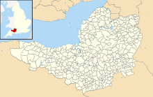
Recent governments have encouraged the formation of town and parish councils in unparished areas, and the
Bath and North East Somerset
The area of the city of Bath which was part of Bath County Borough is unparished.
North Somerset
The whole of the district is parished.
Somerset (district)
The whole of the district is parished.
See also
References
- ^ "The Parish Councils Bill". The Times. 27 March 1893. p. 8.
- ^ HMSO. Local Government Act 1972. 1972 c.70
- ^ "Somerset Records Office". The History of the Somerset Archives Service. Somerset Archives Service. Archived from the original on 4 March 2016. Retrieved 24 September 2016.
- ^ "Local Government Act 1972" (PDF). legislation.gov.uk. Retrieved 29 June 2023.
- ^ "The English Non-Metropolitan Districts (Definition) Order 1972, part 1; part 33". legislation.gov.uk. Retrieved 29 June 2023.
- ^ "The Avon (Structural Change) Order 1995, part II". legislation.gov.uk. Retrieved 29 June 2023.
- ^ "Lieutenancies Act 1997, schedule 1". legislation.gov.uk. Retrieved 29 June 2023.
- ^ "Somerset councils merger approved by government". BBC News. 29 May 2018. Archived from the original on 2 June 2018. Retrieved 30 May 2018.
- ^ "The Somerset (Structural Changes) Order 2022, part 2". legislation.gov.uk. Retrieved 29 June 2023.
- ^ "Next steps for new unitary councils in Cumbria, North Yorkshire and Somerset". GOV.UK. Retrieved 1 January 2022.
- ^ a b c d e f g h i j k l m n o p q r s t u v w x y z aa ab ac ad ae af ag ah ai aj ak al am an ao "2011 Census Profile" (Excel). North Somerset Council. Archived (PDF) from the original on 29 January 2017. Retrieved 29 January 2017.
- ISBN 978-0-7478-0470-3.
- ^ "The Poor Law : Introduction". The Victorian Web. Archived from the original on 11 April 2010. Retrieved 22 August 2009.
- ^ "The New Poor Law". The Workhouse. Archived from the original on 12 October 2016. Retrieved 29 January 2017.
- ^ "A Vision of Britain Through Time : Status Details for Rural Sanitary District". Great Britain Historical GIS Project 2004/University of Portsmouth. Data Office for National Statistics, for England and Wales. Archived from the original on 14 May 2011. Retrieved 22 August 2009.
- ISBN 978-0-19-820718-4.
- ^ a b "Modern British Surnames : Selected Events in the History of Civil Registration and Boundary Changes 1801–1996". Archived from the original on 20 August 2008. Retrieved 22 August 2009.
- ^ MacMorran, Alexander; Colquhoun Dill, T. R. (1907). The Local Government Act 1894 and the Subsequent Statutes Affecting Parish Councils. London: Butterworth and Co.
- ^ a b c d "Local Government Act 1972". Office of Public Sector Information. Archived from the original on 5 December 2012. Retrieved 22 August 2009.
- ^ "Local Government and Rating Act 1997". Office of Public Sector Information. Archived from the original on 8 May 2016. Retrieved 29 January 2017.
- ^ "Local Government and Public Involvement in Health Act 2007". Office of Public Sector Information. Archived from the original on 1 February 2017. Retrieved 29 January 2017.
- ^ "Bathampton Parish". Neighbourhood Statistics. Office for National Statistics. Archived from the original on 1 January 2014. Retrieved 31 December 2013.
- ^ a b c d e f g h i j k l m n o p q r s t u v w "Bathavon RD". A vision of Britain Through Time. University of Portsmouth. Archived from the original on 13 October 2013. Retrieved 4 January 2014.
- ^ "Batheaston Parish". Neighbourhood Statistics. Office for National Statistics. Archived from the original on 1 January 2014. Retrieved 31 December 2013.
- ^ "Bathford Parish". Neighbourhood Statistics. Office for National Statistics. Archived from the original on 1 January 2014. Retrieved 31 December 2013.
- ^ "Camerton Parish". Neighbourhood Statistics. Office for National Statistics. Archived from the original on 1 January 2014. Retrieved 31 December 2013.
- ^ "Charlcombe Parish". Neighbourhood Statistics. Office for National Statistics. Archived from the original on 1 January 2014. Retrieved 31 December 2013.
- ^ "Chelwood Parish". Neighbourhood Statistics. Office for National Statistics. Archived from the original on 1 January 2014. Retrieved 31 December 2013.
- ^ a b c d e f g h i j k l m n o p q r s t u v w "Clutton RD". A vision of Britain Through Time. University of Portsmouth. Archived from the original on 13 October 2013. Retrieved 4 January 2014.
- ^ "Chew Magna Parish". Neighbourhood Statistics. Office for National Statistics. Archived from the original on 1 January 2014. Retrieved 31 December 2013.
- ^ "Chew Stoke Parish". Neighbourhood Statistics. Office for National Statistics. Retrieved 31 December 2013.
- ^ "Claverton Parish". Neighbourhood Statistics. Office for National Statistics. Archived from the original on 1 January 2014. Retrieved 31 December 2013.
- ^ "Clutton Parish". Neighbourhood Statistics. Office for National Statistics. Archived from the original on 1 January 2014. Retrieved 31 December 2013.
- ^ "Combe Hay Parish". Neighbourhood Statistics. Office for National Statistics. Retrieved 31 December 2013.
- ^ "Compton Dando Parish". Neighbourhood Statistics. Office for National Statistics. Retrieved 31 December 2013.
- ^ a b c "Keynsham UD". A vision of Britain Through Time. University of Portsmouth. Archived from the original on 13 October 2013. Retrieved 4 January 2014.
- ^ "Compton Martin Parish". Neighbourhood Statistics. Office for National Statistics. Retrieved 31 December 2013.
- ^ "Corston Parish". Neighbourhood Statistics. Office for National Statistics. Archived from the original on 1 January 2014. Retrieved 31 December 2013.
- ^ "Dunkerton Parish". Neighbourhood Statistics. Office for National Statistics. Archived from the original on 1 January 2014. Retrieved 31 December 2013.
- ^ "East Harptree Parish". Neighbourhood Statistics. Office for National Statistics. Archived from the original on 1 January 2014. Retrieved 31 December 2013.
- ^ "Englishcombe Parish". Neighbourhood Statistics. Office for National Statistics. Archived from the original on 1 January 2014. Retrieved 31 December 2013.
- ^ "Farmborough Parish". Neighbourhood Statistics. Office for National Statistics. Archived from the original on 1 January 2014. Retrieved 31 December 2013.
- ^ "Farrington Gurney Parish". Neighbourhood Statistics. Office for National Statistics. Archived from the original on 1 January 2014. Retrieved 31 December 2013.
- ^ "Freshford Parish". Neighbourhood Statistics. Office for National Statistics. Archived from the original on 1 January 2014. Retrieved 31 December 2013.
- ^ "High Littleton Parish". Neighbourhood Statistics. Office for National Statistics. Archived from the original on 1 January 2014. Retrieved 31 December 2013.
- ^ "Hinton Blewett Parish". Neighbourhood Statistics. Office for National Statistics. Archived from the original on 1 January 2014. Retrieved 31 December 2013.
- ^ "Hinton Charterhouse Parish". Neighbourhood Statistics. Office for National Statistics. Archived from the original on 1 January 2014. Retrieved 31 December 2013.
- ^ "Kelston Parish". Neighbourhood Statistics. Office for National Statistics. Archived from the original on 1 January 2014. Retrieved 31 December 2013.
- ^ "Keynsham Parish". Neighbourhood Statistics. Office for National Statistics. Archived from the original on 1 January 2014. Retrieved 31 December 2013.
- ^ "Marksbury Parish". Neighbourhood Statistics. Office for National Statistics. Archived from the original on 1 January 2014. Retrieved 31 December 2013.
- ^ "Midsomer Norton Parish". Neighbourhood Statistics. Office for National Statistics. Archived from the original on 1 January 2014. Retrieved 31 December 2013.
- ^ a b c "Norton Radstock UD". A vision of Britain Through Time. University of Portsmouth. Archived from the original on 5 January 2014. Retrieved 4 January 2014.
- ^ "Monkton Combe Parish". Neighbourhood Statistics. Office for National Statistics. Archived from the original on 1 January 2014. Retrieved 31 December 2013.
- ^ "Nempnett Thrubwell Parish". Neighbourhood Statistics. Office for National Statistics. Archived from the original on 1 January 2014. Retrieved 31 December 2013.
- ^ "Newton St Loe Parish". Neighbourhood Statistics. Office for National Statistics. Archived from the original on 1 January 2014. Retrieved 31 December 2013.
- ^ "Norton Malreward Parish". Neighbourhood Statistics. Office for National Statistics. Archived from the original on 1 January 2014. Retrieved 31 December 2013.
- ^ "Paulton Parish". Neighbourhood Statistics. Office for National Statistics. Archived from the original on 1 January 2014. Retrieved 31 December 2013.
- ^ "Peasedown St John Parish". Neighbourhood Statistics. Office for National Statistics. Archived from the original on 1 January 2014. Retrieved 31 December 2013.
- ^ "Priston Parish". Neighbourhood Statistics. Office for National Statistics. Archived from the original on 1 January 2014. Retrieved 31 December 2013.
- ^ "Publow Parish". Neighbourhood Statistics. Office for National Statistics. Archived from the original on 1 January 2014. Retrieved 31 December 2013.
- ^ "Radstock Parish". Neighbourhood Statistics. Office for National Statistics. Archived from the original on 1 January 2014. Retrieved 31 December 2013.
- ^ "Saltford Parish". Neighbourhood Statistics. Office for National Statistics. Archived from the original on 1 January 2014. Retrieved 31 December 2013.
- ^ "Shoscombe Parish". Neighbourhood Statistics. Office for National Statistics. Archived from the original on 1 January 2014. Retrieved 31 December 2013.
- ^ "Southstoke Parish". Neighbourhood Statistics. Office for National Statistics. Archived from the original on 1 January 2014. Retrieved 31 December 2013.
- ^ "Stanton Drew Parish". Neighbourhood Statistics. Office for National Statistics. Archived from the original on 1 January 2014. Retrieved 31 December 2013.
- ^ "Stowey-Sutton Parish". Neighbourhood Statistics. Office for National Statistics. Archived from the original on 1 January 2014. Retrieved 31 December 2013.
- ^ "Swainswick Parish". Neighbourhood Statistics. Office for National Statistics. Archived from the original on 1 January 2014. Retrieved 31 December 2013.
- ^ "Cameley Parish". Neighbourhood Statistics. Office for National Statistics. Archived from the original on 1 January 2014. Retrieved 31 December 2013.
- ^ "Timsbury Parish". Neighbourhood Statistics. Office for National Statistics. Archived from the original on 1 January 2014. Retrieved 31 December 2013.
- ^ "Ubley Parish". Neighbourhood Statistics. Office for National Statistics. Archived from the original on 1 January 2014. Retrieved 31 December 2013.
- ^ "Wellow Parish". Neighbourhood Statistics. Office for National Statistics. Archived from the original on 1 January 2014. Retrieved 31 December 2013.
- ^ "Westfield Parish". Neighbourhood Statistics. Office for National Statistics. Archived from the original on 1 January 2014. Retrieved 31 December 2013.
- ^ "West Harptree Parish". Neighbourhood Statistics. Office for National Statistics. Archived from the original on 1 January 2014. Retrieved 31 December 2013.
- ^ "Whitchurch Parish". Neighbourhood Statistics. Office for National Statistics. Archived from the original on 1 January 2014. Retrieved 31 December 2013.
- ^ a b c d e f g h i j k l m n o p q r "Long Ashton RD". A vision of Britain Through Time. University of Portsmouth. Archived from the original on 12 October 2013. Retrieved 4 January 2014.
- ^ a b c d e f g h i j k l m n o p q r s t u v w x y z aa ab ac ad ae af ag ah ai "Axbridge RD". A vision of Britain Through Time. University of Portsmouth. Archived from the original on 13 October 2013. Retrieved 4 January 2014.
- ^ "Clevedon UD". A vision of Britain Through Time. University of Portsmouth. Archived from the original on 13 October 2013. Retrieved 4 January 2014.
- ^ "Portishead". ONS. Retrieved 15 March 2018.
- ^ "Mendip Parish Population Statistics" (PDF). ONS Census 2001. Somerset County Council. Archived from the original (PDF) on 21 November 2009. Retrieved 3 July 2008.
- ^ "Ashwick Parish". Neighbourhood Statistics. Office for National Statistics. Archived from the original on 2 January 2014. Retrieved 1 January 2014.
- ^ a b c d e f g h i j k l m n o p q r s "Shepton Mallet RD". A vision of Britain Through Time. University of Portsmouth. Archived from the original on 5 January 2014. Retrieved 4 January 2014.
- ^ "Baltonsborough Parish". Neighbourhood Statistics. Office for National Statistics. Archived from the original on 2 January 2014. Retrieved 1 January 2014.
- ^ a b c d e f g h i j k l m n o "Wells RD". A vision of Britain Through Time. University of Portsmouth. Archived from the original on 5 January 2014. Retrieved 4 January 2014.
- ^ "Batcombe Parish". Neighbourhood Statistics. Office for National Statistics. Archived from the original on 2 January 2014. Retrieved 1 January 2014.
- ^ "Beckington Parish". Neighbourhood Statistics. Office for National Statistics. Archived from the original on 2 January 2014. Retrieved 1 January 2014.
- ^ a b c d e f g h i j k l m n o p q r s t u "Frome RD". A vision of Britain Through Time. University of Portsmouth. Archived from the original on 16 October 2013. Retrieved 4 January 2014.
- ^ "Berkley Parish". Neighbourhood Statistics. Office for National Statistics. Archived from the original on 2 January 2014. Retrieved 1 January 2014.
- ^ "Binegar Parish". Neighbourhood Statistics. Office for National Statistics. Archived from the original on 2 January 2014. Retrieved 1 January 2014.
- ^ "Buckland Dinham Parish". Neighbourhood Statistics. Office for National Statistics. Retrieved 1 January 2014.
- ^ "Butleigh Parish". Neighbourhood Statistics. Office for National Statistics. Archived from the original on 2 January 2014. Retrieved 1 January 2014.
- ^ "Chewton Mendip Parish". Neighbourhood Statistics. Office for National Statistics. Archived from the original on 2 January 2014. Retrieved 1 January 2014.
- ^ "Chilcompton Parish". Neighbourhood Statistics. Office for National Statistics. Archived from the original on 2 January 2014. Retrieved 1 January 2014.
- ^ "Coleford Parish". Neighbourhood Statistics. Office for National Statistics. Archived from the original on 2 January 2014. Retrieved 1 January 2014.
- ^ "Cranmore Parish". Neighbourhood Statistics. Office for National Statistics. Archived from the original on 2 January 2014. Retrieved 1 January 2014.
- ^ "Croscombe Parish". Neighbourhood Statistics. Office for National Statistics. Archived from the original on 2 January 2014. Retrieved 1 January 2014.
- ^ "Ditcheat Parish". Neighbourhood Statistics. Office for National Statistics. Archived from the original on 2 January 2014. Retrieved 1 January 2014.
- ^ "Doulting Parish". Neighbourhood Statistics. Office for National Statistics. Archived from the original on 2 January 2014. Retrieved 1 January 2014.
- ^ "East Pennard Parish". Neighbourhood Statistics. Office for National Statistics. Retrieved 1 January 2014.
- ^ "Emborough Parish". Neighbourhood Statistics. Office for National Statistics. Archived from the original on 2 January 2014. Retrieved 1 January 2014.
- ^ "Evercreech Parish". Neighbourhood Statistics. Office for National Statistics. Archived from the original on 2 January 2014. Retrieved 1 January 2014.
- ^ "Frome Parish". Neighbourhood Statistics. Office for National Statistics. Archived from the original on 2 January 2014. Retrieved 1 January 2014.
- ^ "Glastonbury Parish". Neighbourhood Statistics. Office for National Statistics. Archived from the original on 2 January 2014. Retrieved 1 January 2014.
- ^ "Glastonbury MB". A vision of Britain Through Time. University of Portsmouth. Archived from the original on 5 January 2014. Retrieved 4 January 2014.
- ^ "Godney Parish". Neighbourhood Statistics. Office for National Statistics. Archived from the original on 6 September 2015. Retrieved 1 January 2014.
- ^ "Great Elm Parish". Neighbourhood Statistics. Office for National Statistics. Retrieved 1 January 2014.
- ^ "Hemington Parish". Neighbourhood Statistics. Office for National Statistics. Archived from the original on 2 January 2014. Retrieved 1 January 2014.
- ^ "Holcombe Parish". Neighbourhood Statistics. Office for National Statistics. Archived from the original on 2 January 2014. Retrieved 1 January 2014.
- ^ "Kilmersdon Parish". Neighbourhood Statistics. Office for National Statistics. Archived from the original on 2 January 2014. Retrieved 1 January 2014.
- ^ "Lamyat Parish". Neighbourhood Statistics. Office for National Statistics. Archived from the original on 2 January 2014. Retrieved 1 January 2014.
- ^ "Leigh-on-Mendip Parish". Neighbourhood Statistics. Office for National Statistics. Archived from the original on 2 January 2014. Retrieved 1 January 2014.
- ^ "Litton Parish". Neighbourhood Statistics. Office for National Statistics. Archived from the original on 2 January 2014. Retrieved 1 January 2014.
- ^ "Lullington Parish". Neighbourhood Statistics. Office for National Statistics. Archived from the original on 2 January 2014. Retrieved 1 January 2014.
- ^ "Lydford-on-Fosse Parish". Neighbourhood Statistics. Office for National Statistics. Archived from the original on 2 January 2014. Retrieved 1 January 2014.
- ^ "Meare Parish". Neighbourhood Statistics. Office for National Statistics. Archived from the original on 2 January 2014. Retrieved 1 January 2014.
- ^ "Mells Parish". Neighbourhood Statistics. Office for National Statistics. Archived from the original on 2 January 2014. Retrieved 1 January 2014.
- ^ "North Wootton Parish". Neighbourhood Statistics. Office for National Statistics. Retrieved 1 January 2014.
- ^ "Norton St Philip Parish". Neighbourhood Statistics. Office for National Statistics. Retrieved 1 January 2014.
- ^ "Nunney Parish". Neighbourhood Statistics. Office for National Statistics. Archived from the original on 2 January 2014. Retrieved 1 January 2014.
- ^ "Pilton Parish". Neighbourhood Statistics. Office for National Statistics. Archived from the original on 2 January 2014. Retrieved 1 January 2014.
- ^ "Priddy Parish". Neighbourhood Statistics. Office for National Statistics. Archived from the original on 2 January 2014. Retrieved 1 January 2014.
- ^ "Pylle Parish". Neighbourhood Statistics. Office for National Statistics. Archived from the original on 2 January 2014. Retrieved 1 January 2014.
- ^ "Rode Parish". Neighbourhood Statistics. Office for National Statistics. Archived from the original on 2 January 2014. Retrieved 1 January 2014.
- ^ "Rodney Stoke Parish". Neighbourhood Statistics. Office for National Statistics. Retrieved 1 January 2014.
- ^ "Selwood Parish". Neighbourhood Statistics. Office for National Statistics. Archived from the original on 2 January 2014. Retrieved 1 January 2014.
- ^ "Sharpham Parish". Neighbourhood Statistics. Office for National Statistics. Archived from the original on 2 January 2014. Retrieved 1 January 2014.
- ^ "Shepton Mallet Parish". Neighbourhood Statistics. Office for National Statistics. Retrieved 1 January 2014.
- ^ "Shepton Mallet UD". A vision of Britain Through Time. University of Portsmouth. Archived from the original on 13 October 2013. Retrieved 4 January 2014.
- ^ "St Cuthbert Out Parish". Neighbourhood Statistics. Office for National Statistics. Retrieved 1 January 2014.
- ^ "Stoke St Michael Parish". Neighbourhood Statistics. Office for National Statistics. Retrieved 1 January 2014.
- ^ "Ston Easton Parish". Neighbourhood Statistics. Office for National Statistics. Retrieved 1 January 2014.
- ^ "Stratton on the Fosse Parish". Neighbourhood Statistics. Office for National Statistics. Retrieved 1 January 2014.
- ^ "Street Parish". Neighbourhood Statistics. Office for National Statistics. Archived from the original on 2 January 2014. Retrieved 1 January 2014.
- ^ "Street UD". A vision of Britain Through Time. University of Portsmouth. Archived from the original on 5 January 2014. Retrieved 4 January 2014.
- ^ "Tellisford Parish". Neighbourhood Statistics. Office for National Statistics. Archived from the original on 2 January 2014. Retrieved 1 January 2014.
- ^ "Trudoxhill Parish". Neighbourhood Statistics. Office for National Statistics. Archived from the original on 2 January 2014. Retrieved 1 January 2014.
- ^ "Upton Noble Parish". Neighbourhood Statistics. Office for National Statistics. Retrieved 1 January 2014.
- ^ "Walton Parish". Neighbourhood Statistics. Office for National Statistics. Archived from the original on 2 January 2014. Retrieved 1 January 2014.
- ^ "Wanstrow Parish". Neighbourhood Statistics. Office for National Statistics. Archived from the original on 2 January 2014. Retrieved 1 January 2014.
- ^ "Wells Parish". Neighbourhood Statistics. Office for National Statistics. Archived from the original on 2 January 2014. Retrieved 1 January 2014.
- ^ "West Bradley Parish". Neighbourhood Statistics. Office for National Statistics. Retrieved 1 January 2014.
- ^ "West Pennard Parish". Neighbourhood Statistics. Office for National Statistics. Retrieved 1 January 2014.
- ^ "Westbury Parish". Neighbourhood Statistics. Office for National Statistics. Archived from the original on 2 January 2014. Retrieved 1 January 2014.
- ^ "Whatley Parish". Neighbourhood Statistics. Office for National Statistics. Archived from the original on 2 January 2014. Retrieved 1 January 2014.
- ^ "Witham Friary Parish". Neighbourhood Statistics. Office for National Statistics. Retrieved 1 January 2014.
- ^ "Wookey Parish". Neighbourhood Statistics. Office for National Statistics. Archived from the original on 2 January 2014. Retrieved 1 January 2014.
- ^ a b c d e f g h i j k l m n o p q r s t u v w x y z aa ab ac ad ae af ag ah ai aj ak al am an ao ap aq ar as at au av aw ax ay az ba bb bc bd be bf bg bh bi bj bk bl bm bn bo bp bq br bs bt bu bv bw bx by bz ca cb cc cd ce cf cg ch ci cj ck cl cm cn co cp cq cr cs ct cu cv cw cx cy cz da db dc dd de df dg dh di dj dk dl dm dn do dp dq dr ds dt du dv dw dx dy dz ea eb ec ed ee ef eg eh ei ej ek el em en eo ep eq er es et eu ev ew ex ey ez fa fb fc fd fe ff fg fh fi fj fk fl fm fn fo fp fq fr fs ft fu fv fw fx fy fz ga gb gc gd ge gf gg gh gi gj gk gl gm gn go gp gq gr gs gt gu gv gw gx gy gz ha hb hc hd he hf hg hh hi hj hk hl hm hn ho hp hq hr hs ht hu hv hw hx hy hz ia ib ic id ie if "Statistics for Wards, LSOAs and Parishes — SUMMARY Profiles". Somerset Intelligence. Archived from the original (Excel) on 4 January 2014. Retrieved 4 January 2014.
- ^ a b c d e f g h i j k l m n o p q r s t u v w x y z aa ab ac ad ae af ag ah ai aj ak al "Brdigwater RD". A vision of Britain Through Time. University of Portsmouth. Archived from the original on 21 October 2013. Retrieved 4 January 2014.
- ^ "Burnham UD". A vision of Britain Through Time. University of Portsmouth. Archived from the original on 5 January 2014. Retrieved 4 January 2014.
- ^ a b c d e f g h i j k l m n o p q r s t u v w x y z aa ab ac "Wincanton RD". A vision of Britain Through Time. University of Portsmouth. Archived from the original on 5 January 2014. Retrieved 4 January 2014.
- ^ a b c d e f g h i j k l m n o p q r s t u v w x y "Langport RD". A vision of Britain Through Time. University of Portsmouth. Archived from the original on 5 January 2014. Retrieved 4 January 2014.
- ^ a b c d e f g h i j k l m n o p q r s t u v w x y z aa ab ac "Yeovil RD". A vision of Britain Through Time. University of Portsmouth. Archived from the original on 8 December 2013. Retrieved 4 January 2014.
- ^ a b c d e f g h i j k l m n o p q r s t u v w x y z aa ab ac ad ae af "Chard RD". A vision of Britain Through Time. University of Portsmouth. Archived from the original on 5 January 2014. Retrieved 4 January 2014.
- ^ "Crewkerne UD". A vision of Britain Through Time. University of Portsmouth. Archived from the original on 5 January 2014. Retrieved 4 January 2014.
- ^ "Bulletin of change 2014 Final" (PDF). Lgbce. Archived from the original (PDF) on 16 March 2018. Retrieved 15 March 2018.
- ^ "Yeovil MB". A vision of Britain Through Time. University of Portsmouth. Archived from the original on 5 January 2014. Retrieved 4 January 2014.
- ^ "The South Somerset (Reorganisation of Community Governance) Order 2022" (PDF). Local Government Boundary Commission for England. Archived from the original (PDF) on 20 March 2022. Retrieved 21 May 2022.
- ^ a b c d e f g h i j k l m "Wellington RD". A vision of Britain Through Time. University of Portsmouth. Archived from the original on 30 December 2013. Retrieved 5 January 2014.
- ^ a b c d e f g h i j k l m n o p q r s t u v w x y z aa ab ac "Taunton RD". A vision of Britain Through Time. University of Portsmouth. Archived from the original on 6 January 2014. Retrieved 5 January 2014.
- ^ a b c d e f g h i j k l m n o p q r s t u v w x y z aa ab ac "Williton RD". A vision of Britain Through Time. University of Portsmouth. Archived from the original on 6 January 2014. Retrieved 5 January 2014.
- ^ a b c d e f g h i j k "Dulverton RD". A vision of Britain Through Time. University of Portsmouth. Archived from the original on 13 October 2013. Retrieved 5 January 2014.
- ^ a b c d e "Statistics for Wards, LSOAs and Parishes — SUMMARY Profiles". Somerset Intelligence. Archived from the original (Excel) on 4 January 2014. Retrieved 4 January 2014.
- ^ a b c d "Taunton RD". A vision of Britain Through Time. University of Portsmouth. Archived from the original on 6 January 2014. Retrieved 5 January 2014.
- ^ "Wellington RD". A vision of Britain Through Time. University of Portsmouth. Archived from the original on 30 December 2013. Retrieved 5 January 2014.
- ^ "Minehead UD". A vision of Britain Through Time. University of Portsmouth. Archived from the original on 6 January 2014. Retrieved 5 January 2014.
- ^ "Watchet UD". A vision of Britain Through Time. University of Portsmouth. Archived from the original on 6 January 2014. Retrieved 5 January 2014.
- ^ "Wellington UD". A vision of Britain Through Time. University of Portsmouth. Archived from the original on 1 January 2014. Retrieved 5 January 2014.


