
Walls of Thessaloniki
This article includes a list of general references, but it lacks sufficient corresponding inline citations. (November 2022) |
| UNESCO World Heritage Site | |
|---|---|
 The eastern walls | |
| Location | Thessaloniki, Greece |
| Part of | Paleochristian and Byzantine Monuments of Thessaloniki |
| Criteria | Cultural: i, ii, iv |
| Reference | 456-002 |
| Inscription | 1988 (12th Session) |
| Coordinates | 40°38′33″N 22°57′16″E / 40.64250°N 22.95444°E |
 Location of Walls of Thessaloniki in Greece | |


The Walls of Thessaloniki (
In 1988, as part of the
History
The first fortification of the newly built city of
In the 3rd century, fortifications were built to protect the city from the Goths with materials from previous buildings. With these fortifications, two Gothic attacks were repelled, in 254 and 268. The Roman wall was 1.65 m wide, with square towers.[2] The main street of the city (Leoforos or Mesi) extended from the Golden Gate in the west (Vardario Square) to the Cassandreot Gate in the east. The southern wall extended somewhat further south of today's Tsimiski avenue.
At the beginning of the 4th century, Galerius and Constantine the Great passed through Thessaloniki and strengthened the walls. At the end of the 4th century, a second wall was built outside the previous one with triangular projections. The wall visible today was built from the end of the 4th to the middle of the 5th century,[3] while a subsequent improvement program was implemented in the 7th century on Heraklion in order to support the defense of the city against the Avars and the Slavs. In 904 the city was captured by the Saracens by an attack from the sea side, which led to the sea walls being strengthened after the departure of the Saracens.
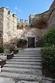
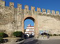
Gallery
-
 The walls c.1919
 -
 Part of the walls with one of the surviving gates on the background
 -
 Part of the walls
 -
 Gate of Anna Palaiologina
 -
 Part of the walls beside the street
 -
 Walls in Ano Poli
 -
 "Portara" Gate
 -
 Trigonio tower (“Triangle Tower”)
 -
 View from the Triangle tower
 -
 Another view


.jpg)


_(5._Jhdt.)_(32900082707).jpg)
_(5._Jhdt.)_(33966657338).jpg)
References
- ^ "Paleochristian and Byzantine monuments of Thessaloniki". UNESCO World Heritage Convention. United Nations Educational, Scientific, and Cultural Organization. Archived from the original on 5 January 2021. Retrieved 5 November 2022.
- ^ )
- PMID 960.
Sources
- Kourkoutidou-Nikolaidou, E.; Tourta, A. (1997), Wandering in Byzantine Thessaloniki, Kapon Editions, pp. 15–26, ISBN 960-7254-47-3
External links
 Media related to Walls of Thessaloniki at Wikimedia Commons
Landmarks of Thessaloniki | ||
|---|---|---|
| Macedonian period |
|  |
| Roman period | ||
| Paleochristian and Byzantine | ||
| Ottoman period | ||
| Modern period | ||
| Jewish sites | ||
| Streets | ||
| Villas/Mansions | ||
| Gardens/Parks | ||
| Marinas |
| |
| Other | ||
| Museums |
| |
| Events | ||
.jpg)
.jpg)


