
List of districts of Karnataka
The southern Indian state of Karnataka consists of 31 districts grouped into 4 administrative divisions, viz., Belagavi, Bengaluru ,

History

Karnataka took its present shape in 1956, when the former states of
Formations of districts
| Date | New district | Formerly part of | Administration |
|---|---|---|---|
| 15 August 1986 | Bengaluru Urban
|
Bengaluru | Ramakrishna Hegde's ministry |
Bengaluru Rural
| |||
| 25 August 1997 | Chamarajanagara | Mysuru
|
J. H. Patel's ministry |
| Davanagere | Shivamogga
| ||
| Bagalakote | Vijayapura
| ||
| Gadaga | Dharwad | ||
| Udupi | Dakshina Kannada | ||
| Koppala | Raichur | ||
| 21 June 2007 | Ramanagara | Bengaluru Rural
|
H.D. Kumaraswamy's ministry[3] |
| Chikkaballapura | Kolar
| ||
| 30 December 2009 | Yadagiri[4]
|
Kalaburagi | B.S. Yediyurappa's second ministry |
| 18 November 2020 | Vijayanagara[5] | Ballari
|
B.S. Yediyurappa's fourth ministry
|
Currently there are demands to carve out the following district,
- Belagavi(largest district)
- Tumakuru
- Sirsi from Uttara Kannada
- Bagalkote
Administrative structure

A district of an Indian state is an administrative geographical unit, headed by a
A
A Deputy Conservator of Forests, an officer belonging to the Indian Forest Service selected through the UPSC examination is responsible for managing the forests, the environment and wildlife of the district. He is assisted by the officers of the Karnataka Forest Service selected through the KPSC examination.
Sect-oral development is looked after by the district head of each development department such as Public Works, Health, Education, Agriculture, Animal husbandry, etc. These officers belong to the various state services.
Administrative divisions
| Belagavi Division | Bengaluru Division | Kalaburagi Division | Mysuru Division |
|---|---|---|---|
|
|
|
Alphabetical listing of districts
Code[6] District Headquarters[7] Established[8][9] Subdivisions(Taluka) Population[10](As of 2011[update]) Area[7] Population density[10](As of 2011[update]) Map BAG
Bagalkote 15 August 1997[11] 1,889,752 6,575 km2 (2,539 sq mi) 288/km2 (750/sq mi) 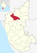
BEU Bengaluru 1 November 1956 9,621,551 2,190 km2 (850 sq mi) 4,393/km2 (11,380/sq mi) 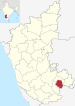
BER Bengaluru 15 August 1986[12]
- Devanahalli
- Doddaballapura
- Nelamangala
990,923 2,259 km2 (872 sq mi) 431/km2 (1,120/sq mi) 
BEL 1 November 1956 4,779,661 13,415 km2 (5,180 sq mi) 356/km2 (920/sq mi) 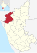
BAL 1 November 1956 1,400,970 4,252 km2 (1,642 sq mi) 290/km2 (750/sq mi) 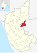
BID Bidar 1 November 1956
- Bidar
- Basavakalyan
- Kamalnagar
- Chitgoppa
- Bhalki
- Aurad
1,703,300 5,448 km2 (2,103 sq mi) 313/km2 (810/sq mi) 
VIJ 1 November 1956
- Indi
- Muddebihal
- Babaleshwar
- Nidagundi
- Tikota
- Devara Hippargi
- Chadchan
- Kolhar
- Almel
2,177,331 10,498 km2 (4,053 sq mi) 210/km2 (540/sq mi) 
CHA Chamarajanagar 15 August 1997[11] 1,020,791 5,101 km2 (1,970 sq mi) 181/km2 (470/sq mi) 
CHI Chikkaballapura 10 September 2007[11]
- Bagepalli
- Chintamani
- Gauribidanur
- Sidlaghatta
- Manchenahalli
1,255,104 4,524 km2 (1,747 sq mi)[13] 296/km2 (770/sq mi) 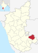
CHK Chikkamagaluru 1 November 1956 1,137,961 7,201 km2 (2,780 sq mi) 158/km2 (410/sq mi) 
CHT Chitradurga 1 November 1956 1,659,456 8,440 km2 (3,260 sq mi) 197/km2 (510/sq mi) 
DAK 1 November 1956
- Bantwal
- Mangalore
- Moodabidri
- Kadaba
- Puttur
2,089,649 4,560 km2 (1,760 sq mi) 430/km2 (1,100/sq mi) 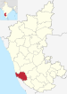
DAV Davanagere Davanagere 15 August 1997[11]
- Channagiri
- Davanagere
- Harihar
- Jagalur
- Nyamati
1,643,494 4,460 km2 (1,720 sq mi) 370/km2 (960/sq mi) 
DHA Dharwad 1 November 1956 1,847,023 4,260 km2 (1,640 sq mi) 434/km2 (1,120/sq mi) 
GAD 24 August 1997[11]
- Mundargi
- Nargund
- Gajendragad
- Ron
1,064,570 4,656 km2 (1,798 sq mi) 229/km2 (590/sq mi) 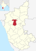
KAL Kalaburagi Kalaburagi 1 November 1956 2,566,326 10,951 km2 (4,228 sq mi) 234/km2 (610/sq mi) 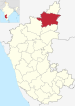
HAS 1 November 1956
- Alur
- Arkalgud
- Arsikere
- Belur
- Sakleshpur
1,776,421 6,814 km2 (2,631 sq mi) 261/km2 (680/sq mi) 
HAV Haveri 24 August 1997[11] 1,597,668 4,823 km2 (1,862 sq mi) 331/km2 (860/sq mi) 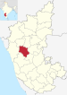
KOD Madikeri 1 November 1956
- Madikeri
- Kushalanagar
- Virajpet
- Ponnampet
554,519 4,102 km2 (1,584 sq mi) 135/km2 (350/sq mi) 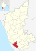
KL Kolar 1 November 1956
- Bangarapet
- Kolar
- Kolar Gold Fields
- Malur
- Srinivaspur
1,536,401 3,969 km2 (1,532 sq mi)[14] 386/km2 (1,000/sq mi) 
KOP Koppal 24 August 1997[11]
- Kanakagiri
- Kuknur
- Karatagi
- Koppal
- Kushtagi
1,389,920 7,189 km2 (2,776 sq mi) 250/km2 (650/sq mi) 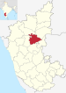
MAN Mandya 1 November 1956[15][16]
- Maddur
- Malavalli
- Mandya
- Nagamangala
- Pandavapura
1,805,769 4,961 km2 (1,915 sq mi) 364/km2 (940/sq mi) 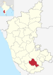
MYS Mysuru 1 November 1956
- Hunsur
- Krishnarajanagara
- Mysore
- Nanjangud
3,001,127 6,854 km2 (2,646 sq mi) 476/km2 (1,230/sq mi) 
RAI Raichur 1 November 1956 1,928,812 8,440 km2 (3,260 sq mi) 228/km2 (590/sq mi) 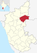
RAM Ramanagara 10 September 2007[11] 1,082,636 3,556 km2 (1,373 sq mi) 308/km2 (800/sq mi) 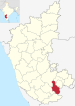
SHI Shivamogga 1 November 1956
- Hosanagara
- Sagar
- Shimoga
- Thirthahalli
1,752,753 8,477 km2 (3,273 sq mi) 207/km2 (540/sq mi) 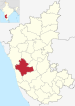
TUM Tumakuru Tumakuru 1 November 1956
- Gubbi
- Huliyar
- Koratagere
- Kunigal
- Madhugiri
- Pavagada
- Tiptur
- Tumkur
- Turuvekere
2,678,980 10,597 km2 (4,092 sq mi) 253/km2 (660/sq mi) 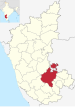
UDU Udupi 25 August 1997[11] 1,177,361 3,880 km2 (1,500 sq mi) 329/km2 (850/sq mi) 
UTK Karwara 1 November 1956 1,437,169 10,291 km2 (3,973 sq mi) 140/km2 (360/sq mi) 
VIJ Vijayanagara Hospet 18 November 2020 1,353,628 5,644 km2 (2,179 sq mi) 240/km2 (620/sq mi) 
YAD Yadgiri Yadgiri 30 December 2009 1,174,271 5,234 km2 (2,021 sq mi)
224/km2 (580/sq mi) 


See also
References
- ^ "Petition against transfer of Bellary dismissed". Indian Express. 30 September 1953. Retrieved 17 December 2010.
- ^ Chinnappa, Jeevan (15 November 2005). "Did reorganisation panel ignore Kodava leaders' plea?". The Hindu. Archived from the original on 12 December 2006. Retrieved 17 December 2010.
- ^ "2 new districts notified in Bangalore". The Times of India. 6 August 2007. Archived from the original on 11 August 2011. Retrieved 9 August 2007.
- ^ "Creation of Yadgir district". Online Edition of The Hindu, dated 2009-12-30. Chennai, India. 30 December 2009.
- ^ "Vijayanagar to be Karnataka's 31st district, BSY Cabinet gives in-principle nod". The New Indian Express. 19 November 2020. Retrieved 23 November 2020.
- ^ "NIC Policy on format of e-mail Address: Appendix (2): Districts Abbreviations as per ISO 3166–2" (PDF). Ministry Of Communications and Information Technology, Government of India. 18 August 2004. pp. 5–10. Archived from the original (PDF) on 11 September 2008. Retrieved 24 November 2008.
- ^ a b "Know India – Districts of Karnataka". Government of India portal. Retrieved 16 November 2010.
- ^ Here 'Established' means year of establishment as a district of Karnataka. If the district was formed earlier to the formation of district in the state of Karnataka, 1 November 1956 will be considered as the day of establishment of the district.
- ^ "STATES REORGANISATION ACT 1956 - Formation of a new Mysore State". Archived from the original on 16 May 2008. Retrieved 17 November 2010.
- ^ a b "List of districts of Karnataka".
- ^ a b c d e f g h i "A Handbook of Karnataka – Administration" (PDF). Government of Karnataka. pp. 354, 355. Archived from the original (PDF) on 8 October 2011. Retrieved 16 November 2010.
- ^ "District Profile". Archived from the original on 29 November 2010. Retrieved 18 November 2010.
- ^ "District Profile – Area and population". Archived from the original on 25 November 2010. Retrieved 18 November 2010.
- ^ "Kolar district at a glance" (PDF). Archived from the original (PDF) on 12 March 2011. Retrieved 18 November 2010.
- ^ Note: This date means the day when the district was initially formed, even before the formation of the state of Karnataka (Mysore). Hence 1 November 1956 will be considered as the day of formation of district in the state of Karnataka
- ^ "Formation of Mandya district". Archived from the original on 2 August 2010. Retrieved 18 November 2010.
External links
| States | ||
|---|---|---|
| Union territories | ||
| Related topics |
| |