
List of volcanoes in Indonesia

The
Volcanoes in
The most active volcano is
As of 2012, Indonesia has 127 active volcanoes and about 5 million people live within the danger zones. It has been conjectured that the
The word for Mount in Indonesian and many regional languages of the country is Gunung. Thus, Mount Merapi may be referred to as Gunung Merapi.
Scope

There is no single standard definition of a volcano. It can be defined as individual vents, volcanic edifices, or volcanic fields. The interior of ancient volcanoes may have been eroded, creating a new subsurface
The primary source of the list below is taken from the
Geographical groups
Sumatra

The geography of
Only one of the 35 active volcanoes,


Sunda Strait and Java
The
Java is a relatively small island compared to Sumatra, but
| Name | Shape | Elevation | Last eruption ( VEI ) |
Coordinates |
|---|---|---|---|---|
| Krakatau | caldera | 813 metres (2,667 ft) | 2022 (ongoing) | 6°06′07″S 105°25′23″E / 6.102°S 105.423°E |
| Pulosari | stratovolcano | 1,346 metres (4,416 ft) | unknown | 6°20′31″S 105°58′30″E / 6.342°S 105.975°E |
| Gunung Karang | stratovolcano | 1,778 metres (5,833 ft) | unknown | 6°16′12″S 106°02′31″E / 6.27°S 106.042°E |
| Salak | stratovolcano | 2,211 metres (7,254 ft) | 31 January 1938 (2) | 6°43′S 106°44′E / 6.72°S 106.73°E |
| Kiaraberes-Gagak | stratovolcano | 1,511 metres (4,957 ft) | 6 April 1939 (1) | 6°44′S 106°39′E / 6.73°S 106.65°E |
Perbakti |
stratovolcano | 1,699 metres (5,574 ft) | unknown | 6°45′S 106°41′E / 6.75°S 106.68°E |
| Kendeng | stratovolcano | 1,732 metres (5,682 ft) | Pleistocene | 6°46′05″S 106°31′34″E / 6.768°S 106.526°E |
| Gede | stratovolcano | 2,958 metres (9,705 ft) | 13 March 1957 (2) | 6°47′S 106°59′E / 6.78°S 106.98°E |
| Patuha | stratovolcano | 2,434 metres (7,986 ft) | unknown | 7°09′36″S 107°24′00″E / 7.160°S 107.40°E |
Wayang-Windu |
lava dome | 2,182 metres (7,159 ft) | unknown | 7°12′29″S 107°37′48″E / 7.208°S 107.63°E |
| Malabar | stratovolcano | 2,343 metres (7,687 ft) | unknown | 7°08′S 107°39′E / 7.13°S 107.65°E |
| Tangkuban Perahu | stratovolcano | 2,084 metres (6,837 ft) | 26 June 2019 (1) | 6°46′S 107°36′E / 6.77°S 107.60°E |
| Papandayan | stratovolcano | 2,665 metres (8,743 ft) | 11 November 2002 (2) | 7°19′S 107°44′E / 7.32°S 107.73°E |
| Kendang | stratovolcano | 2,608 metres (8,556 ft) | unknown | 7°14′S 107°43′E / 7.23°S 107.72°E |
| Kamojang | stratovolcano | 1,730 metres (5,680 ft) | Pleistocene | 7°07′30″S 107°48′00″E / 7.125°S 107.80°E |
| Guntur | complex volcano | 2,249 metres (7,379 ft) | 16 October 1847 (2) | 7°08′35″S 107°50′24″E / 7.143°S 107.840°E |
| Tampomas | stratovolcano | 1,684 metres (5,525 ft) | unknown | 6°46′S 107°57′E / 6.77°S 107.95°E |
| Galunggung | stratovolcano | 2,168 metres (7,113 ft) | 9 January 1984 (1) | 7°15′00″S 108°03′29″E / 7.25°S 108.058°E |
| Talagabodas | stratovolcano | 2,201 metres (7,221 ft) | unknown | 7°12′29″S 108°04′12″E / 7.208°S 108.07°E |
| Karaha | fumarole | 1,155 metres (3,789 ft) | unknown | 7°07′S 108°05′E / 7.12°S 108.08°E |
| Cereme | stratovolcano | 3,078 metres (10,098 ft) | 1951 | 6°53′31″S 108°24′00″E / 6.892°S 108.40°E |
| Slamet | stratovolcano | 3,432 metres (11,260 ft) | 2014 | 7°14′31″S 109°12′29″E / 7.242°S 109.208°E |
| Dieng | complex volcano | 2,565 metres (8,415 ft) | 29 April 2021 (?) | 7°12′S 109°55′E / 7.20°S 109.92°E |
Sundoro |
stratovolcano | 3,136 metres (10,289 ft) | 29 October 1971 (2) | 7°18′00″S 109°59′31″E / 7.30°S 109.992°E |
| Sumbing | stratovolcano | 3,371 metres (11,060 ft) | 1730 (?) | 7°23′02″S 110°04′12″E / 7.384°S 110.070°E |
| Ungaran | stratovolcano | 2,050 metres (6,730 ft) | unknown | 7°11′S 110°20′E / 7.18°S 110.33°E |
| Telomoyo | stratovolcano | 1,894 metres (6,214 ft) | unknown | 7°22′S 110°24′E / 7.37°S 110.40°E |
Merbabu |
stratovolcano | 3,145 metres (10,318 ft) | 1797 (2) | 7°27′S 110°26′E / 7.45°S 110.43°E |
| Merapi | stratovolcano | 2,968 metres (9,738 ft) | 2019 (ongoing) | 7°32′31″S 110°26′31″E / 7.542°S 110.442°E |
| Muria | stratovolcano | 1,625 metres (5,331 ft) | 160 BC ± 30 years | 6°37′S 110°53′E / 6.62°S 110.88°E |
| Lawu | stratovolcano | 3,265 metres (10,712 ft) | 28 November 1885 (1) | 7°37′30″S 111°11′31″E / 7.625°S 111.192°E |
| Wilis | stratovolcano | 2,563 metres (8,409 ft) | unknown | 7°48′29″S 111°45′29″E / 7.808°S 111.758°E |
| Kelud | stratovolcano | 1,731 metres (5,679 ft) | 13 February 2014 (4) | 7°55′48″S 112°18′29″E / 7.93°S 112.308°E |
| Kawi–Butak | stratovolcano | 2,651 metres (8,698 ft) | unknown | 7°55′S 112°27′E / 7.92°S 112.45°E |
Welirang |
stratovolcano | 3,339 metres (10,955 ft) | 15 August 1952 (0) | 7°43′30″S 112°34′48″E / 7.725°S 112.58°E |
| Penanggungan | stratovolcano | 1,653 metres (5,423 ft) | unknown | 7°37′S 112°38′E / 7.62°S 112.63°E |
| Malang Plain | maar | 680 metres (2,230 ft) | unknown | 8°01′S 112°41′E / 8.02°S 112.68°E |
| Semeru | stratovolcano | 3,676 metres (12,060 ft) | 2021 (ongoing) | 8°06′29″S 112°55′12″E / 8.108°S 112.92°E |
| Bromo | stratovolcano | 2,329 metres (7,641 ft) | 2021 | 7°56′31″S 112°57′00″E / 7.942°S 112.95°E |
| Lamongan | stratovolcano | 1,651 metres (5,417 ft) | 5 February 1898 (2) | 7°58′44″S 113°20′31″E / 7.979°S 113.342°E |
| Lurus | complex volcano | 539 metres (1,768 ft) | unknown | 7°44′S 113°35′E / 7.73°S 113.58°E |
| Iyang-Argapura | complex volcano | 3,088 metres (10,131 ft) | unknown | 7°58′S 113°34′E / 7.97°S 113.57°E |
| Raung | stratovolcano | 3,332 metres (10,932 ft) | 2021 (?) | 8°07′30″S 114°02′31″E / 8.125°S 114.042°E |
| Ijen | stratovolcano | 2,799 metres (9,183 ft) | 28 June 1999 (1) | 8°03′29″S 114°14′31″E / 8.058°S 114.242°E |
| Baluran | stratovolcano | 1,247 metres (4,091 ft) | unknown | 7°51′S 114°22′E / 7.85°S 114.37°E |
Note: Height of Krakatau is of Rakata, not of the active Anak Krakatau
-
 Tangkuban Perahu, taken from above
 -
 A plinian eruption of Galunggung in 1982
 -
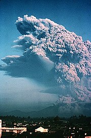
 Mount Merapi, one of the most famous volcanoes in Indonesia
 -
 The turquoise coloured sulfuric acid lake on Ijen caldera
 -
 The 1883 eruption of Krakatoa produced the loudest sound.


Lesser Sunda Islands
The
| Name | Island | Shape | Elevation | Last eruption ( VEI ) |
Coordinates |
|---|---|---|---|---|---|
| Merbuk | Bali | unknown | 1,386 metres (4,547 ft) | unknown | 8°13′S 114°39′E / 8.22°S 114.65°E |
| Bratan | Bali | caldera | 2,276 metres (7,467 ft) | unknown | 8°17′S 115°08′E / 8.28°S 115.13°E |
| Batur | Bali | caldera | 1,717 metres (5,633 ft) | 2000 (1) | 8°14′31″S 115°22′30″E / 8.242°S 115.375°E |
| Agung | Bali | stratovolcano | 3,031 metres (9,944 ft) | 2019 | 8°20′31″S 115°30′29″E / 8.342°S 115.508°E |
| Samalas | Lombok | stratovolcano | 2,867 metres (9,406 ft) | 1257 (7) | 8°25′S 116°24′E / 8.41°S 116.40°E |
Rinjani |
Lombok | stratovolcano | 3,726 metres (12,224 ft) | 2016 (2) | 8°25′S 116°28′E / 8.42°S 116.47°E |
| Tambora | Sumbawa | stratovolcano | 2,722 metres (8,930 ft) | 1967 ± 20 years (0) | 8°15′S 118°00′E / 8.25°S 118.00°E |
| Sangeang Api | Sangeang | complex volcano | 1,949 metres (6,394 ft) | 2019 (ongoing) | 8°12′S 119°04′E / 8.20°S 119.07°E |
| Wai Sano | Flores | caldera | 903 metres (2,963 ft) | unknown | 8°43′S 120°01′E / 8.72°S 120.02°E |
| Poco Leok | Flores | unknown | 1,675 metres (5,495 ft) | unknown | 8°41′S 120°29′E / 8.68°S 120.48°E |
| Ranakah | Flores | lava dome | 2,100 metres (6,900 ft) | March 1991 (1) | 8°37′S 120°31′E / 8.62°S 120.52°E |
| Inierie | Flores | stratovolcano | 2,245 metres (7,365 ft) | 8050 BC | 8°52′30″S 120°57′00″E / 8.875°S 120.95°E |
| Inielika | Flores | complex volcano | 1,559 metres (5,115 ft) | 11 January 2001 (2) | 8°44′S 120°59′E / 8.73°S 120.98°E |
| Ebulobo | Flores | stratovolcano | 2,124 metres (6,969 ft) | 27 February 1969 (2) | 8°49′S 121°11′E / 8.82°S 121.18°E |
| Iya | Flores | stratovolcano | 637 metres (2,090 ft) | 27 January 1969 (3) | 8°53′49″S 121°38′42″E / 8.897°S 121.645°E |
| Sukaria | Flores | caldera | 1,500 metres (4,900 ft) | unknown | 8°47′31″S 121°46′12″E / 8.792°S 121.77°E |
| Ndete Napu | Flores | fumarole | 750 metres (2,460 ft) | unknown | 8°43′S 121°47′E / 8.72°S 121.78°E |
| Kelimutu | Flores | complex volcano | 1,639 metres (5,377 ft) | 3 June 1968 (1) | 8°46′S 121°49′E / 8.77°S 121.82°E |
| Paluweh | Palu'e | stratovolcano | 875 metres (2,871 ft) | 3 February 1985 (1) | 8°19′12″S 121°42′29″E / 8.32°S 121.708°E |
| Egon | Flores | stratovolcano | 1,703 metres (5,587 ft) | 2008 | 8°40′S 122°27′E / 8.67°S 122.45°E |
| Ilimuda | Flores | stratovolcano | 1,100 metres (3,600 ft) | unknown | 8°28′41″S 122°40′16″E / 8.478°S 122.671°E |
| Lewotobi | Flores | stratovolcano | 1,703 metres (5,587 ft) | 2024 | 8°32′31″S 122°46′30″E / 8.542°S 122.775°E |
| Leroboleng | Flores | complex volcano | 1,117 metres (3,665 ft) | 26 June 2003 (3) | 8°21′29″S 122°50′31″E / 8.358°S 122.842°E |
| Riang Kotang | Flores | fumarole | 200 metres (660 ft) | unknown | 8°18′00″S 122°53′31″E / 8.30°S 122.892°E |
| Iliboleng | Adonara Island | stratovolcano | 1,659 metres (5,443 ft) | June 1993 (1) | 8°20′31″S 123°15′29″E / 8.342°S 123.258°E |
Lewotolo |
Lembata | stratovolcano | 1,423 metres (4,669 ft) | 2020 (ongoing) | 8°16′19″S 123°30′18″E / 8.272°S 123.505°E |
| Ililabalekan | Lembata | stratovolcano | 1,018 metres (3,340 ft) | unknown | 8°33′S 123°23′E / 8.55°S 123.38°E |
| Iliwerung | Lembata | complex volcano | 1,018 metres (3,340 ft) | 29 November 2021 | 8°32′S 123°34′E / 8.53°S 123.57°E |
Batu Tara |
Komba island | stratovolcano | 748 metres (2,454 ft) | 2007–2015 (2) | 7°47′31″S 123°34′44″E / 7.792°S 123.579°E |
Sirung |
Pantar Island |
complex volcano | 862 metres (2,828 ft) | 2021 | 8°30′29″S 124°07′48″E / 8.508°S 124.13°E |
| Yersey | – | submarine | −3,800 metres (−12,500 ft) | unknown | 7°32′S 123°57′E / 7.53°S 123.95°E |
-
 Mount Agung on Bali
 -
 Eruption ofRinjaniin 1984
 -
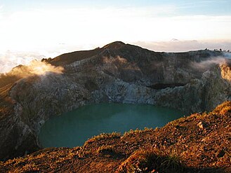 One of three different coloured lakes of Kelimutu


Banda Sea
The
| Name | Shape | Elevation | Last eruption ( VEI ) |
Coordinates |
|---|---|---|---|---|
| Emperor of China | submarine | −2,850 metres (−9,350 ft) | unknown | 6°37′S 124°13′E / 6.62°S 124.22°E |
| Nieuwerkerk | submarine | −2,285 metres (−7,497 ft) | unknown | 6°36′00″S 124°40′30″E / 6.60°S 124.675°E |
| Gunungapi Wetar | stratovolcano | 282 metres (925 ft) | 1699 (3) | 6°38′31″S 126°39′00″E / 6.642°S 126.65°E |
| Wurlali | stratovolcano | 868 metres (2,848 ft) | 3 June 1892 (2) | 7°07′30″S 128°40′30″E / 7.125°S 128.675°E |
| Teon | stratovolcano | 655 metres (2,149 ft) | 3 June 1904 (2) | 6°55′12″S 129°07′30″E / 6.92°S 129.125°E |
| Nila | stratovolcano | 781 metres (2,562 ft) | 7 May 1968 (1) | 6°44′S 129°30′E / 6.73°S 129.50°E |
| Serua | stratovolcano | 641 metres (2,103 ft) | 18 September 1921 (2) | 6°18′S 130°00′E / 6.30°S 130.00°E |
Manuk |
stratovolcano | 282 metres (925 ft) | unknown | 5°31′48″S 130°17′31″E / 5.53°S 130.292°E |
| Banda Api | caldera | 640 metres (2,100 ft) | 9 May 1988 (3) | 4°31′30″S 129°52′16″E / 4.525°S 129.871°E |
Sulawesi and Sangihe Islands
Four peninsulas dominate the shape of Sulawesi island (formerly known as Celebes). The central part is a high mountainous area, but mostly non-volcanic. Active volcanoes are found in the northern peninsula and continuously stretch to the north to Sangihe Islands. The Sangihe Islands mark the border with the Philippines.
| Name | Shape | Elevation | Last eruption ( VEI ) |
Coordinates |
|---|---|---|---|---|
Colo |
stratovolcano | 507 metres (1,663 ft) | 18 July 1983 (4) | 0°10′12″S 121°36′29″E / 0.17°S 121.608°E |
| Ambang | complex volcano | 1,795 metres (5,889 ft) | 1845 ± 5 years | 0°45′N 124°25′E / 0.75°N 124.42°E |
| Soputan | stratovolcano | 1,784 metres (5,853 ft) | December 2018 | 1°06′29″N 124°43′48″E / 1.108°N 124.73°E |
| Sempu | caldera | 1,549 metres (5,082 ft) | unknown | 1°07′48″N 124°45′29″E / 1.13°N 124.758°E |
| Tondano | caldera | 1,202 metres (3,944 ft) | unknown | 1°14′N 124°50′E / 1.23°N 124.83°E |
| Lokon–Empung | stratovolcano | 1,580 metres (5,180 ft) | 2015 | 1°21′29″N 124°47′31″E / 1.358°N 124.792°E |
| Mahawu | stratovolcano | 1,324 metres (4,344 ft) | 16 November 1977 (0) | 1°21′29″N 124°51′29″E / 1.358°N 124.858°E |
| Klabat | stratovolcano | 1,995 metres (6,545 ft) | unknown | 1°28′N 125°02′E / 1.47°N 125.03°E |
Tongkoko |
stratovolcano | 1,149 metres (3,770 ft) | 1880 (1) | 1°31′N 125°12′E / 1.52°N 125.20°E |
Ruang |
stratovolcano | 725 metres (2,379 ft) | April 2024 (ongoing) | 2°18′N 125°22′E / 2.30°N 125.37°E |
| Karangetang | stratovolcano | 1,784 metres (5,853 ft) | 2019 (ongoing) | 2°47′N 125°24′E / 2.78°N 125.40°E |
| Banua Wuhu | submarine | −5 metres (−16 ft) | 18 July 1919 (3) | 3°08′17″N 125°29′28″E / 3.138°N 125.491°E |
| Awu | stratovolcano | 1,320 metres (4,330 ft) | 2 June 2004 (2) | 3°40′N 125°30′E / 3.67°N 125.50°E |
| Submarine 1922 | submarine | −5,000 metres (−16,000 ft) | unknown | 3°58′N 125°10′E / 3.97°N 125.17°E |
Halmahera
| Name | Shape | Elevation | Last eruption ( VEI ) |
Coordinates |
|---|---|---|---|---|
Tarakan |
pyroclastic cone |
318 metres (1,043 ft) | unknown | 1°50′N 127°50′E / 1.83°N 127.83°E |
| Dukono | complex volcano | 1,335 metres (4,380 ft) | 1933–2021 (ongoing) | 1°41′N 127°53′E / 1.68°N 127.88°E |
| Tobaru | unknown | 1,035 metres (3,396 ft) | unknown | 1°38′N 127°40′E / 1.63°N 127.67°E |
| Ibu | stratovolcano | 1,325 metres (4,347 ft) | 2024 | 1°29′17″N 127°37′48″E / 1.488°N 127.63°E |
| Gamkonora | stratovolcano | 1,635 metres (5,364 ft) | 9 July 2007 (?) | 1°23′N 127°32′E / 1.38°N 127.53°E |
| Todoko-Ranu | caldera | 979 metres (3,212 ft) | unknown | 1°15′N 127°28′E / 1.25°N 127.47°E |
Jailolo |
stratovolcano | 1,130 metres (3,710 ft) | unknown | 1°05′N 127°25′E / 1.08°N 127.42°E |
| Hiri | stratovolcano | 630 metres (2,070 ft) | unknown | 0°54′N 127°19′E / 0.90°N 127.32°E |
| Gamalama | stratovolcano | 1,715 metres (5,627 ft) | 2018 | 0°48′N 127°20′E / 0.80°N 127.33°E |
| Tidore | stratovolcano | 1,730 metres (5,680 ft) | unknown | 0°39′29″N 127°24′00″E / 0.658°N 127.40°E |
Mare |
stratovolcano | 308 metres (1,010 ft) | unknown | 0°34′N 127°24′E / 0.57°N 127.40°E |
Moti |
stratovolcano | 950 metres (3,120 ft) | unknown | 0°27′N 127°24′E / 0.45°N 127.40°E |
| Makian | stratovolcano | 1,357 metres (4,452 ft) | 29 July 1988 (3) | 0°19′N 127°24′E / 0.32°N 127.40°E |
| Tigalalu | stratovolcano | 422 metres (1,385 ft) | unknown | 0°04′N 127°25′E / 0.07°N 127.42°E |
| Amasing | stratovolcano | 1,030 metres (3,380 ft) | unknown | 0°32′S 127°29′E / 0.53°S 127.48°E |
| Bibinoi | stratovolcano | 900 metres (3,000 ft) | unknown | 0°46′S 127°43′E / 0.77°S 127.72°E |

Major eruptions
Below is a list of selected major eruptions of volcanoes in Indonesia, sorted chronologically by the starting date of the eruption. Only eruptions with scale 3 or above on
| Eruption date | Volcano | Cessation date | VEI |
Characteristics | Tsunami | Tephra volume | Fatality | Sources |
|---|---|---|---|---|---|---|---|---|
| 3 December 2023 | Marapi | 8 December 2023 | 3 | cv,se,pf,fa,lm,cc | no | N/A | 24 | |
| 4 December 2021 | Semeru | 5 December 2021 | 4 | cv,se,pf,fa,lm,cc | no | N/A | 69 | |
| 21 December 2018 | Anak Krakatoa | 10 January 2019 | 3 | cv,se,pf,fa,lm,cc | 1–2 m | N/A | 437 | [20][21] |
| 13 February 2014 | Kelut | 15 February 2014 | 4 | cv,cl,pf,ph,ld,lm | no | 0.16 km3 | 4 | [22] |
| 3 November 2010 | Merapi | 8 November 2010 | 4 | cv,pf,ld,lm | no | N/A | 353 | [5] |
| 10 February 1990 | Kelut |
March 1990 | 4 | cv,cl,pf,ph,ld,lm | no | 0.13 km3 | 35 | [23] |
| 18 July 1983 | Colo |
December 1983 | 4 | cv,pf,ph | no | N/A | 0 | [23] |
| 5 April 1982 | Galunggung | 8 January 1983 | 4 | cv,pf,lf,lm | no | 0.37 km3 + | 68 | [24][25] |
| 6 October 1972 | Merapi | March 1985 | 2 | cv,pf,lf,ld,lm | no | 0.021 km3 | 29 | [5] |
| 26 April 1966 | Kelut | 27 April 1966 | 4 | cv,cl,pf,lm | no | 0.089 km3 | 212 | [23] |
| 17 March 1963 | Agung | 27 January 1964 | 5 | cv,pf,lf,lm | no | 1 km3 | 1,148 | [26] |
| 31 August 1951 | Kelut | 31 August 1951 | 4 | cv,cl,pf,lm | no | 0.2 km3 | 7 | [23] |
| 25 November 1930 | Merapi | September 1931 | 3 | cv,rf,pf,lf,ld,lm | no | 0.0017 km3 | 1,369 | [5] |
| 19 May 1919 | Kelut | 20 May 1919 | 4 | cv,cl,pf,lm | no | 0.19 km3 | 5,110 | [23] |
| 7 June 1892 | Awu | 12 June 1892 | 3 | cv,pf,lm | yes | N/A | 1,532 | [27] |
| 26 August 1883 | Krakatoa | February 1884 | 6 | cv,se,pf,fa,lm,cc | 15–42 m | 5–8.5 km3 | 36,600 | [1][26][28] |
| 15 April 1872 | Merapi | 21 April 1872 | 4 | cv,pf | no | 0.33 km3 | 200 | [5] |
| 2 March 1856 | Awu | 17 March 1856 | 3 | cv,pf,lm | yes | 0.51±0.50 km3 | 2,806 | [27] |
| 8 October 1822 | Galunggung | December 1822 | 5 | cv,pf,ld,lm | no | 1 km3 + | 4,011 | [23] |
| 10 April 1815 | Mount Tambora | 15 July 1815 | 7 | cv,pf,cc | 1–2 m | 160 km3 | 71,000+ | [3][29] |
| 6 August 1812 | Awu | 8 August 1812 | 4 | cv,pf,lm | no | 0.55±0.50 km3 | 963 | [27] |
| 12 August 1772 | Papandayan | 12 August 1772 | 3 | cv,ph | no | N/A | 2,957 | [30] |
| 4 August 1672 | Merapi | unknown | 3 | cv,pf,lm | no | N/A | 3,000 | [5] |
| 1586 | Kelut | unknown | 5 | cf,cl,lm | no | 1 km3 + | 10,000 | [23] |
| September 1257 | Samalas | unknown | 7 | [31] | ||||
| ≈ 74,000 BP | Toba | unknown | 8 | pf,lf,cc | likely | 2,800 km3 | Possible near extinction of all the human population | [2] |
See also
- List of earthquakes in Indonesia
- Lists of volcanoes
- List of disasters in Indonesia
- Volcanism of Indonesia
- Volcanism of Java
- List of Ultras of the Malay Archipelago
References
Notes
- ^ ISBN 978-0-06-621285-2.
- ^ .
- ^ S2CID 23649251.
- ^ "Kelut Eruptive History". Global Volcanism Program. Smithsonian Institution. Retrieved 19 December 2006.
- ^ a b c d e f "Merapi Eruptive History". Global Volcanism Program. Smithsonian Institution. Retrieved 19 December 2006.
- ^ "Indonesia Miliki 127 Gunung Api Aktif". 2 May 2012.
- ^ "Volcano Data Criteria". Global Volcanism Program. Smithsonian Institution. Retrieved 14 June 2015.
- ^ "Centre of Volcanology & Geological Hazard Mitigation". Volcanological Survey of Indonesia. Archived from the original on 16 December 2006. Retrieved 31 December 2006.
- ^ (PDF) from the original on 9 September 2006.
- (PDF) from the original on 9 September 2006.
- (PDF) from the original on 11 September 2006.
- ^ "Smithsonian / USGS Weekly Volcanic Activity Report". Smithsonian Institution. 15 August 2020. Retrieved 15 August 2020.
- ^ "Masurai". Global Volcanism Program. Smithsonian Institution.
- S2CID 155054596.
- ^ "Semeru Weekly Reports". Global Volcanism Program. Smithsonian Institution. Retrieved 7 December 2006.
- S2CID 195243529.
- S2CID 128470417.
- JSTOR 1788584.
- .
- ^ "The rise and fall of Anak Krakatau | VolcanoCafe". 4 January 2019. Retrieved 13 June 2019.
- ^ "Global Volcanism Program | Krakatau". volcano.si.edu. Retrieved 13 June 2019.
- ^ "Kelut Eruptive History". volcano.si.edu. Retrieved 13 June 2019.
- ^ a b c d e f g "Large Holocene Eruptions". Global Volcanism Program. Smithsonian Institution. Retrieved 18 December 2006.
- ^ Katili, J.A. & Sudradjat, A. (1984). "Galunggung: the 1982-1983 eruption". Volcanology Survei Indonesia: 102.
- ^ "Galunggung, Java, Indonesia". Volcano World. Department of Geosciences at Oregon State University. Archived from the original on 16 June 2008. Retrieved 30 December 2006.
- ^ S2CID 140594715.
- ^ a b c "Awu's Eruptive History". Global Volcanism Program. Smithsonian Institution. Retrieved 31 December 2006.
- .
- S2CID 131663534.
- ^ "The Deadliest Eruptions". Volcano World. Department of Geosciences at Oregon State University. Archived from the original on 25 January 2009. Retrieved 15 March 2009.
- S2CID 127929333.
Sources
- ISBN 978-0-945005-12-4.
- ^ M. Neumann van Padang (1951). "Indonesia". Catalog of Active Volcanoes of the World and Solfatara Fields (1 ed.). Rome: IAVCEI. pp. 1–271.