
User:Cruickshanks/sandbox4


The History of Oceania includes the history of Australia, New Zealand, Papua New Guinea, Fiji and other Pacific island nations .
Prehistory
Polynesia theories

The Polynesian people are considered to be by linguistic, archaeological and human genetic ancestry a subset of the sea-migrating
There are three theories regarding the spread of humans across the Pacific to Polynesia. These are outlined well by Kayser et al. (2000)[4] and are as follows:
- Express Train model: A recent (c. 3000–1000 BC) expansion out of Taiwan, via the linguisticdata, and archaeological data.
- Entangled Bank model: Emphasizes the long history of Austronesian speakers' cultural and genetic interactions with indigenous Island Southeast Asians and Melanesians along the way to becoming the first Polynesians.
- Slow Boat model: Similar to the express-train model but with a longer hiatus in Melanesia along with admixture, both genetically, culturally and linguistically with the local population. This is supported by the Y-chromosome data of Kayser et al. (2000), which shows that all three haplotypes of Polynesian Y chromosomes can be traced back to Melanesia.[5]
In the archaeological record there are well-defined traces of this expansion which allow the path it took to be followed and dated with some certainty. It is thought that by roughly 1400 BC, the small differences in dates with Samoa being due to differences in radiocarbon dating technologies between 1989 and 2010, the Tongan site apparently predating the Samoan site by some few decades in real time.
Within a mere three or four centuries between about 1300 and 900 BC, the Lapita archaeological culture spread 6,000 km further to the east from the Bismarck Archipelago, until it reached as far as Fiji, Tonga, and Samoa.[9][10] The area of Tonga, Fiji, and Samoa served as a gateway into the rest of the Pacific region known as Polynesia.[11] Ancient Tongan mythologies recorded by early European explorers report the islands of 'Ata and Tongatapu as the first islands being hauled to the surface from the deep ocean by Maui.[12][13]
The
Modern archeology, anthropology and linguistic studies confirm widespread Tongan cultural influence ranging widely[16][17] through East 'Uvea, Rotuma, Futuna, Samoa and Niue, parts of Micronesia (Kiribati, Pohnpei), Vanuatu, and New Caledonia and the Loyalty Islands,[18] and while some academics prefer the term "maritime chiefdom",[19] others argue that, while very different to examples elsewhere, ..."empire" is probably the most convenient term.[20]
The first settlements in Fiji were started by voyaging traders and settlers from the west about 5000 years ago.
Over the centuries, a unique Fijian culture developed. Constant warfare and cannibalism between warring tribes were quite rampant and very much part of everyday life.[21] In later centuries, the ferocity of the cannibal lifestyle deterred European sailors from going near Fijian waters, giving Fiji the name Cannibal Isles; as a result, Fiji remained unknown to the rest of the world.[22]
Some scientists say that Easter Island was not inhabited until 700-800 CE. This date range is based on glottochronological calculations and on three radiocarbon dates from charcoal that appears to have been produced during forest clearance activities.[25]
Moreover, a recent study which included radiocarbon dates from what is thought to be very early material suggests that the island was settled as recently as 1200 CE.
Micronesia theories
Micronesia began to be settled several millennia ago, although there are competing theories about the origin and arrival of the first settlers.
The ancestors of the Micronesians settled there over 4,000 years ago. A decentralized chieftain-based system eventually evolved into a more centralized economic and religious Micronesian Empire centered on Yap and Pohnpei.[33] The prehistory of many Micronesian islands such as Yap are not known very well.[34]


On
Construction of
The first people of the Northern Mariana Islands navigated to the islands at some period between 4000 BC to 2000 BC from Southeast Asia. They became known as the Chamorros, and spoke an Austronesian language called Chamorro. The ancient Chamorro left a number of megalithic ruins, including Latte stone. The Refaluwasch, or Carolinian, people came to the Marianas in the 1800s from the Caroline Islands. Micronesian colonists gradually settled the Marshall Islands during the 2nd millennium BC, with inter-island navigation made possible using traditional stick charts.[45]
Melanesia theories

The first settlers of Australia, New Guinea, and the large islands just to the east arrived between 50,000 and 30,000 years ago, when
Particularly along the north coast of New Guinea and in the islands north and east of New Guinea, the

However, the theory is contradicted by the findings of a
The study found a high rate of genetic differentiation and diversity among the groups living within the Melanesian islands, with the peoples distinguished by island, language, topography, and geography among the islands. Such diversity developed over their tens of thousands of years of settlement before the Polynesian ancestors ever arrived at the islands. For instance, populations developed differently in coastal areas, as opposed to those in more isolated mountainous valleys.[46][50]
Additional DNA analysis has taken research into new directions, as more human species have been discovered since the late 20th century. Based on his genetic studies of the
Melanesians of some islands are one of the few non-European peoples, and the only dark-skinned group of people outside Australia, known to have blond hair.
Indigenous Australians are the original inhabitants of the Australian continent and nearby islands.[52] Indigenous Australians migrated from Africa to Asia around 70,000 years ago[53] and arrived in Australia around 50,000 years ago.[54][55] The Torres Strait Islanders are indigenous to the Torres Strait Islands, which are at the northernmost tip of Queensland near Papua New Guinea. The term "Aboriginal" is traditionally applied to only the indigenous inhabitants of mainland Australia and Tasmania, along with some of the adjacent islands, i.e.: the "first peoples". Indigenous Australians is an inclusive term used when referring to both Aboriginal and Torres Strait islanders.
The earliest definite human remains found to date are that of
European contact and exploration (from 1600s)

Ferdinand Magellan and the Manila Galleons

Oceania was explored by Europeans from the 16th century onwards. In 1519 Ferdinand Magellan sailed down the east coast of South America, found and sailed through the strait that bears his name and on 28 November 1520 entered the Pacific. He then sailed north and caught the trade winds which carried him across the Pacific to the Philippines where he was killed. One surviving ship returned west across the Indian Ocean and the other went north in the hope of finding the westerlies and reaching Mexico. Unable to find the right winds, it was forced to return to the East Indies. The Ferdinand Magellan expedition achieved the first circumnavigation of the world and discovered the Mariana Islands and other islands of Oceania.
In 1565 (44 years later)

Abel Tasman

Abel Tasman was the first known European explorer to reach the islands of Van Diemen's Land (now Tasmania) and New Zealand, and to sight the Fiji islands. His navigator François Visscher, and his merchant Isaack Gilsemans, mapped substantial portions of Australia, New Zealand, Tonga and the Fijian islands.
On 24 November 1642 Abel Tasman sighted the west coast of Tasmania, north of Macquarie Harbour.

After some exploration, Tasman had intended to proceed in a northerly direction but as the wind was unfavourable he steered east. On 13 December they sighted land on the north-west coast of the
On route back to Batavia, Tasman came across the Tongan archipelago on 20 January 1643. While passing the Fiji Islands Tasman's ships came close to being wrecked on the dangerous reefs of the north-eastern part of the Fiji group. He charted the eastern tip of Vanua Levu and Cikobia before making his way back into the open sea. He eventually turned north-west to New Guinea, and arrived at Batavia on 15 June 1643.
For over a century after Tasman's voyages, until the era of James Cook, Tasmania and New Zealand were not visited by Europeans – mainland Australia was visited, but usually only by accident.
-
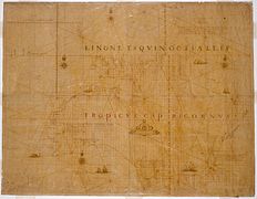 The Abel Tasman map 1644.
 -
![The first European impression of Māori, at Murderers' Bay. Drawing by Isaack Gilsemans in Abel Tasman's travel journal (1642).[62]](//upload.wikimedia.org/wikipedia/commons/thumb/6/6e/Gilsemans_1642.jpg/240px-Gilsemans_1642.jpg) The first European impression of Māori, attravel journal (1642).[62]
The first European impression of Māori, attravel journal (1642).[62] -
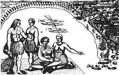 Tongatapu, drawing by Isaack Gilsemans
 -
 The bay of Tongatapu with the two ships, drawing by Isaack Gilsemans

![The first European impression of Māori, at Murderers' Bay. Drawing by Isaack Gilsemans in Abel Tasman's travel journal (1642).[62]](/File:Gilsemans_1642.jpg)


Captain James Cook voyages of exploration
First voyage (1768–71)

In 1766 the
With the help of a Tahitian named
Cook then voyaged west, reaching the south-eastern coast of Australia on 19 April 1770, and in doing so his expedition became the first recorded Europeans to have encountered its eastern coastline.
After his departure from Botany Bay he continued northwards. After a grounding mishap on the Great Barrier Reef, the voyage continued, sailing through Torres Strait before returning to England via Batavia, the Cape of Good Hope, and Saint Helena.

Second voyage (1772–75)
In 1772 the Royal Society commissioned Cook to search for the hypothetical Terra Australis again. On his first voyage, Cook had demonstrated by circumnavigating New Zealand that it was not attached to a larger landmass to the south. Although he charted almost the entire eastern coastline of Australia, showing it to be continental in size, the Terra Australis was believed by the Royal Society to lie further south.[68]
_c._1773.jpg)
Cook commanded HMS Resolution on this voyage, while Tobias Furneaux commanded its companion ship, HMS Adventure. Cook's expedition circumnavigated the globe at an extreme southern latitude, becoming one of the first to cross the Antarctic Circle (17 January 1773). In the Antarctic fog, Resolution and Adventure became separated. Furneaux made his way to New Zealand, where he lost some of his men during an encounter with Māori, and eventually sailed back to Britain, while Cook continued to explore the Antarctic, reaching 71°10'S on 31 January 1774.[69]
Cook almost encountered the mainland of Antarctica, but turned towards Tahiti to resupply his ship. He then resumed his southward course in a second fruitless attempt to find the supposed continent. On this leg of the voyage he brought a young Tahitian named Omai, who proved to be somewhat less knowledgeable about the Pacific than Tupaia had been on the first voyage. On his return voyage to New Zealand in 1774, Cook landed at the Friendly Islands, Easter Island, Norfolk Island, New Caledonia, and Vanuatu.
Before returning to England, Cook made a final sweep across the South Atlantic from Cape Horn. He then turned north to South Africa, and from there continued back to England. His reports upon his return home put to rest the popular myth of Terra Australis.[70]

Third voyage (1776–79)
On his last voyage, Cook again commanded HMS Resolution, while Captain
From the Sandwich Islands Cook sailed north and then north-east to explore the west coast of North America north of the Spanish settlements in Alta California. Cook explored and mapped the coast all the way to the Bering Strait, on the way identifying what came to be known as Cook Inlet in Alaska. In a single visit, Cook charted the majority of the North American north-west coastline on world maps for the first time, determined the extent of Alaska, and closed the gaps in Russian (from the West) and Spanish (from the South) exploratory probes of the Northern limits of the Pacific.[69]
Cook returned to Hawaii in 1779. After sailing around the archipelago for some eight weeks, he made landfall at Kealakekua Bay, on 'Hawaii Island', largest island in the Hawaiian Archipelago. Cook's arrival coincided with the Makahiki, a Hawaiian harvest festival of worship for the Polynesian god Lono. Coincidentally the form of Cook's ship, HMS Resolution, or more particularly the mast formation, sails and rigging, resembled certain significant artefacts that formed part of the season of worship.[73][74] Similarly, Cook's clockwise route around the island of Hawaii before making landfall resembled the processions that took place in a clockwise direction around the island during the Lono festivals. It has been argued (most extensively by Marshall Sahlins) that such coincidences were the reasons for Cook's (and to a limited extent, his crew's) initial deification by some Hawaiians who treated Cook as an incarnation of Lono.[75] Though this view was first suggested by members of Cook's expedition, the idea that any Hawaiians understood Cook to be Lono, and the evidence presented in support of it, were challenged in 1992.[74][76]
After a month's stay, Cook resumed his exploration of the Northern Pacific. Shortly after leaving Hawaii Island, however, the Resolution's foremast broke, so the ships returned to
The esteem which the islanders nevertheless held for Cook caused them to retain his body. Following their practice of the time, they prepared his body with funerary rituals usually reserved for the chiefs and highest elders of the society. The body was disembowelled, baked to facilitate removal of the flesh, and the bones were carefully cleaned for preservation as religious icons in a fashion somewhat reminiscent of the treatment of European saints in the Middle Ages. Some of Cook's remains, thus preserved, were eventually returned to his crew for a formal burial at sea.[80]
Clerke assumed leadership of the expedition.

Colonisation

British colonisation
In 1789 the
Among the last islands in Oceania to be colonised was Niue (1900). In 1887, King Fata-a-iki, who reigned Niue from 1887 to 1896, offered to cede sovereignty to the British Empire, fearing the consequences of annexation by a less benevolent colonial power. The offer was not accepted until 1900. Niue was a British protectorate, but the UK's direct involvement ended in 1901 when New Zealand annexed the island.
French colonisation

French Catholic missionaries arrived on Tahiti in 1834; their expulsion in 1836 caused France to send a gunboat in 1838. In 1842, Tahiti and
On 24 September 1853, under orders from
In the 1880s, France claimed the
Spanish colonisation
The
). The Marshall Islands were claimed by Spain in 1874.Dutch colonisation
In 1606 Luís Vaz de Torres explored the southern coast of New Guinea from Milne Bay to the Gulf of Papua including Orangerie Bay which he named Bahía de San Lorenzo. His expedition also discovered Basilaki Island naming it Tierra de San Buenaventura, which he claimed for Spain in July 1606.[87] On October 18 his expedition reached the western part of the island in present-day Indonesia, and also claimed the territory for the King of Spain.
.png)
A successive European claim occurred in 1828, when the Netherlands formally claimed the western half of the island as
The first Dutch government posts were established in 1898 and in 1902: Manokwari on the north coast, Fak-Fak in the west and Merauke in the south at the border with British New Guinea. The German, Dutch and British colonial administrators each attempted to suppress the still-widespread practices of inter-village warfare and headhunting within their respective territories.[88]
In 1905 the British government transferred some administrative responsibility over southeast New Guinea to Australia (which renamed the area "Territory of Papua"); and in 1906, transferred all remaining responsibility to Australia. During World War I, Australian forces seized German New Guinea, which in 1920 became the Territory of New Guinea, to be administered by Australia under a League of Nations mandate. The territories under Australian administration became collectively known as The Territories of Papua and New Guinea (until February 1942).
German colonisation
Germany established colonies in New Guinea in 1884, and Samoa in 1900.
Following
American colonisation
The
Samoa aligned its interests with the
Cession followed the
Japanese colonisation
At the beginning of
During World War II, Japan colonized many Oceanic colonies by wresting control from western powers.
Samoan Crisis 1887-1889


The Samoan Crisis was a confrontation standoff between the
The standoff ended on 15 and 16 March when a
World War I

The Asian and Pacific Theatre of World War I was a conquest of German colonial possession in the Pacific Ocean and China. The most significant military action was the Siege of Tsingtao in what is now China, but smaller actions were also fought at Battle of Bita Paka and Siege of Toma in German New Guinea.
All other German and Austrian possessions in Asia and the Pacific fell without bloodshed. Naval warfare was common; all of the colonial powers had naval squadrons stationed in the Indian or Pacific Oceans. These fleets operated by supporting the invasions of German held territories and by destroying the East Asia Squadron.
.jpg)
One of the first land offensives in the Pacific theatre was the Occupation of German Samoa in August 1914 by New Zealand forces. The campaign to take Samoa ended without bloodshed after over 1,000 New Zealanders landed on the German colony, supported by an Australian and French naval squadron.
Australian forces attacked German New Guinea in September 1914: 500 Australians encountered 300 Germans and native policemen at the Battle of Bita Paka; the Allies won the day and the Germans retreated to Toma. A company of Australians and a British warship besieged the Germans and their colonial subjects, ending with a German surrender.[91]
After the fall of Toma, only minor German forces were left in New Guinea and these generally capitulated once met by Australian forces. In December 1914, one German officer near Angorum attempted resist the occupation with thirty native police but his force deserted him after they fired on an Australian scouting party and he was subsequently captured.[91]
also fell to Allied forces during the war.World War II

The
The attack on Pearl Harbor[note 3] was a surprise military strike conducted by the Imperial Japanese Navy against the United States naval base at Pearl Harbor, Hawaii, on the morning of December 7, 1941 (December 8 in Japan). The attack led to the United States' entry into World War II.
The attack was intended as a
The Japanese subsequently invaded New Guinea, the Solomon Islands and other Pacific islands. The Japanese were turned back at the Battle of the Coral Sea and the Kokoda Track campaign before they were finally defeated in 1945.
Some of the most prominent Oceanic battlegrounds were the Solomon Islands campaign, the Air raids on Darwin, the Kokada Track, and the Borneo campaign.
In 1940 the administration of French Polynesia recognised the Free French Forces and many Polynesians served in World War II. Unknown at the time to French and Polynesians, the Konoe Cabinet in Imperial Japan on 16 September 1940 included French Polynesia among the many territories which were to become Japanese possessions in the post-war world – though in the course of the war in the Pacific the Japanese were not able to launch an actual invasion of the French islands.
_under_attack_and_burning_during_the_Battle_of_the_Eastern_Solomons_on_24_August_1942_(NH_97778).jpg)
Solomon Islands campaign
Some of the most intense fighting of the Second World War occurred in the Solomons. The most significant of the Allied Forces' operations against the
.The
"The Slot" was a name for New Georgia Sound, when it was used by the Tokyo Express to supply the Japanese garrison on Guadalcanal. Of more than 36,000 Japanese on Guadalcanal, about 26,000 were killed or missing, 9,000 died of disease, and 1,000 were captured.[98]
.jpg)
Kokoda Track campaign
The Kokoda Track campaign was a campaign consisting of a series of battles fought between July and November 1942 between
In sight of Port Moresby itself, the Japanese began to run out of momentum against the Australians who began to receive further reinforcements. Having outrun their supply lines and following the reverses suffered by the Japanese at
Post-war period

In 1946, Polynesians were granted French citizenship and the islands' status was changed to an overseas territory; the islands' name was changed in 1957 to Polynésie Française (French Polynesia).
From 1946 to 1958, the Marshall Islands served as the
Australia and New Zealand became
Modern age
In 1962, France's early nuclear testing ground of Algeria became independent and the Maruroa atoll in the Tuamotu Archipelago was selected as the new testing site; tests were conducted underground after 1974.
Fiji and Tonga became independent in 1970, with many other nations following in the 1970s and 1980s. The South Pacific Forum was founded in 1971, which became the Pacific Islands Forum in 2000. Bougainville Island, geographically part of the Solomon Islands but politically part of Papua New Guinea, tried unsuccessfully to become independent in 1975, and a civil war followed in the early 1990s, with it later being granted autonomy.
On May 1, 1979, in recognition of the evolving political status of the Marshall Islands, the United States recognized the constitution of the Marshall Islands and the establishment of the Government of the
In 1852, French Polynesia was granted partial internal autonomy; in 1984, the autonomy was extended. French Polynesia became a full overseas collectivity of France in 2004.
French
East Timor declared independence from Portugal in 1975, but was invaded by Indonesia, before it was granted full independence in 2002.
Fiji has had a troubled recent history with coups in 1987, 2000 and 2006.
Between 2001 and 2007 Australia's
See also
- Europeans in Oceania
- History of Australia
- History of New Zealand
- History of the Pacific Islands
- List of countries and islands by first human settlement
- List of Oceanian cuisines
Notes
- ^ The Saudeleur era lasted around 500 years.[36] Legend generally dates their downfall to the 1500s,[37] however archaeologists date Saudeleur ruins to ca. 1628.[38][39][40]
- ^ At this time, the International Date Line had yet to be established, so the dates in Cook's journal are a day earlier than those accepted today.
- ^ Also known as the Battle of Pearl Harbor,[92] the Hawaii Operation or Operation AI by the Japanese Imperial General Headquarters,[93][94] and Operation Z during planning.[95]
References
- S2CID 224791767.
- )
- PMID 10899994.)
{{cite journal}}:|first10=missing|last10=(help);|first11=missing|last11=(help - S2CID 744958.
- ^ "Melanesian and Asian Origins of Polynesians: mtDNA and Y Chromosome Gradients Across the Pacific". Anthrocivitas.net. October 2009. Retrieved 23 January 2014.
- ISBN 0520234618. Quoted in Kayser, M.; et al. (2006).
- ^ Green, Roger C.; Leach, Helen M. (1989). "New Information for the Ferry Berth Site, Mulifanua, Western Samoa". Journal of the Polynesian Society. 98 (3). Retrieved 1 November 2009.
- ^ Burley, David V.; Barton, Andrew; Dickinson, William R.; Connaughton, Sean P.; Taché, Karine (2010). "Nukuleka as a Founder Colony for West Polynesian Settlement: New Insights from Recent Excavations". Journal of Pacific Archaeology. 1 (2): 128–144.
- ISBN 0500274509.
- ^ PV Kirch. 1997. The Lapita Peoples. Cambridge: Blackwell Publisher
- ^ see DV Burley. 1998. Tongan Archaeology and the Tongan Past, 2850-150 B.P. In: Journal of World Prehistory 12:337–392
- ^ Honolulu: The Museum
- ^ John Martin. 2005 (reprint). William Mariner: An Account of the Natives of the Tonga Islands in the South Pacific Ocean. Vol. 1. Elibron Classics
- ^ "Ha'amonga 'a Maui (Trilithon) and 'esi Maka Fa'akinanga". Wondermondo.
- ^ "The Pacific Islands: An Encyclopedia," edited by Lal and Fortune, p. 133
- ^ Recent Advances in the Archaeology of the Fiji/West-Polynesia Region" 2008: Vol 21. University of Otago Studies in Prehistoric Anthropology.]
- ^ "Hawaiki, Ancestral Polynesia: An Essay in Historical Anthropology", Patrick Vinton Kirch; Roger C. Green (2001)
- ^ "Geraghty, P., 1994. Linguistic evidence for the Tongan empire", Geraghty, P., 1994 in "Language Contact and Change in the Austronesian World: pp.236-39.
- ^ "Monumentality in the development of the Tongan maritime chiefdom", Clark, G., Burley, D. and Murray, T. 2008. Antiquity 82(318): 994-1004"
- ^ ["Pacific voyaging after the exploration period"], NEICH, R. 2006 in K.R. Howe (ed.) Vaka Moana, voyages of the ancestors: the discovery and settlement of the Pacific: 198-245. Auckland: David Bateman. p230
- ^ Sanday, Peggy Reeves (1986) Divine hunger: cannibalism as a cultural system, Cambridge University Press, p. 151, IBNS 0521311144.
- ^ Pacific Peoples, Melanesia/Micronesia/Polynesia, Central Queensland University.
- ^ Resemblance of the name to an early Mangarevan founder god Atu Motua ("Father Lord") has made some historians suspect that Hotu Matua was added to Easter Island mythology only in the 1860s, along with adopting the Mangarevan language. The "real" founder would have been Tu'u ko Iho, who became just a supporting character in Hotu Matu'a centric legends. See Steven Fischer (1994). Rapanui's Tu'u ko Iho Versus Mangareva's 'Atu Motua. Evidence for Multiple Reanalysis and Replacement in Rapanui Settlement Traditions, Easter Island. The Journal of Pacific History, 29(1), 3-18. See also Rapa Nui / Geography, History and Religion. Peter H. Buck, Vikings of the Pacific, University of Chicago Press, 1938. pp. 228-236. Online version.
- ^ Summary of Thomas S. Barthel's version of Hotu Matu'a's arrival to Easter Island.
- ISBN 0-14-303655-6. Chapter 2: Twilight at Easter pp.79-119. See page 89.
- ^ Hunt, T. L., Lipo, C. P., 2006. Science, 1121879. See also "Late Colonization of Easter Island" in Science Magazine. Entire article is also hosted by the Department of Anthropology of the University of Hawaii.
- .
- ISBN 978-1-4391-5031-3.
- ^ C. Michael Hogan (2008) Chilean Wine Palm: Jubaea chilensis, GlobalTwitcher.com, ed. N. Stromberg
- ^ Kirch 2001, p. 167.
- ^ Lal 2000, p. 62.
- ^ Kirch 2001, p. 170.
- ^ "Background Note: Micronesia". United States Department of State. Retrieved 2012-01-06.
- ISBN 9780292786219.
- ISBN 1-57306-129-8. Retrieved 2012-01-01.
- ^ ISBN 0-8248-1124-0. Retrieved 2012-01-01.
- ISBN 0-8248-1134-8. Retrieved 2011-12-31.
- ISBN 0-292-76506-1. Retrieved 2011-12-31.
- ^ ISBN 1-57306-166-2. Retrieved 2011-12-31.
- ^ Micronesica. University of Guam. 1990. pp. 92, 203, 277. Retrieved 2011-12-31.
- ^ ISBN 0-671-24030-7. Retrieved 2011-12-31.
- ISBN 9780598442437. Retrieved 2012-01-01.
- ^ a b Petersen, Glenn (1990). "5. Isokelekel" (PDF). Lost in the Weeds: Theme and Variation in Pohnpei Political Mythology. Vol. 35. Center for Pacific Islands Studies, School of Hawaiian, Asian & Pacific Studies, University of Hawaiʻi at Mānoa. pp. 34 et seq. Retrieved 2011-12-31.
{{cite book}}:|journal=ignored (help) - ISBN 0-313-29103-9. Retrieved 2011-12-31.
- ^ The History of Mankind by Professor Friedrich Ratzel, Book II, Section A, The Races of Oceania page 165, picture of a stick chart from the Marshall Islands. MacMillan and Co., published 1896.
- ^ a b c d e "Genome Scans Show Polynesians Have Little Genetic Relationship to Melanesians", Press Release, Temple University, 18 January 2008, accessed 9 March 2013
- S2CID 2963726.)
{{cite journal}}: CS1 maint: multiple names: authors list (link - ISBN 0-631-16727-7.
- S2CID 744958.)
{{cite journal}}: CS1 maint: multiple names: authors list (link - ^ Friedlaender, Jonathan; Friedlaender JS; Friedlaender FR; Reed FA; Kidd KK; et al. (2008-01-18). "The Genetic Structure of Pacific Islanders". Public Library of Science. PLoS Genet (4(1): e19 doi=10.1371/journal.pgen.0040019). Philadelphia, PA 19122: )
- ^ a b Carl Zimmer (22 December 2010). "Denisovans Were Neanderthals' Cousins, DNA Analysis Reveals". NYTimes.com. Retrieved 22 December 2010.
- ^ "About Australia:Our Country". Australian Government.
Australia's first inhabitants, the Aboriginal people, are believed to have migrated from some unknown point in Asia to Australia between 50,000 and 60,000 years ago.
- ^ http://www.sciencemag.org/content/334/6052/94.full
- ^ "Aboriginal Australians descend from the first humans to leave Africa, DNA sequence reveals", Biotechnology and Biological Sciences Research Council (BBSRC).
- ^ http://www.illumina.com/documents/icommunity/article_2012_04_Aboriginal_Genome.pdf
- ^ "When did Australia's earliest inhabitants arrive?", University of Wollongong, 2004. Retrieved 6 June 2008.
- ^ "Aboriginal truth and white media: Eric Michaels meets the spirit of Aboriginalism", The Australian Journal of Media & Culture, vol. 3 no 3, 1990. Retrieved 6 June 2008.
- ^ Original map of Tasmania in December 1642
- ^ "European discovery of New Zealand". Encyclopedia of New Zealand. 4 March 2009. Archived from the original on 10 November 2010. Retrieved 9 December 2010.
- ^ Diary of Abel Tasmna p21-22.Random House. 2008
- ^ "First contact violence linked to food". New Zealand Herald. 23 September 2010. Retrieved 23 September 2010.
- ^ http://www.teara.govt.nz/en/history/2/1
- ^ Dance, Nathaniel (c1776). "Captain James Cook, 1728-79". Royal Museums Greenwich. Commissioned by Sir Joseph Banks. Retrieved January 23, 2014.
He holds his own chart of the Southern Ocean on the table and his right hand points to the east coast of Australia on it.
{{cite web}}: Check date values in:|date=(help) - The Sydney Morning Herald (NSW: 1842–1954). NSW: National Library of Australia. 2 May 1931. p. 12. Retrieved 4 September 2012.
- ^ "Secret Instructions to Captain Cook, 30 June 1768" (PDF). National Archives of Australia. Retrieved 3 September 2011.
- ^ "Cook's Journal: Daily Entries, 22 April 1770". Retrieved 21 September 2011.
- ^ "Once were warriors – smh.com.au". The Sydney Morning Herald. 11 November 2002. Retrieved 21 September 2011.
- ^ Hough 1994, p. 182
- ^ a b Williams, Glyn (17 February 2011). "Captain Cook: Explorer, Navigator and Pioneer". BBC. Retrieved 5 September 2011.
- ^ Hough 1994, p. 263
- ^ Collingridge 2003, p. 327
- ^ Collingridge 2003, p. 380
- ^ a b Collingridge 2003
- ^ a b Obeyesekere 1992
- ^ Sahlins 1985
- ^ Obeyesekere 1997
- ^ "The Death of Captain James Cook, 14 February 1779 – National Maritime Museum". National Maritime Museum. Retrieved 11 July 2012.
- ^ Collingridge 2003, p. 410
- ^ Dibble, Sheldon (1843). History of the Sandwich Islands. Lahainaluna: Press of the Mission Seminary. p. 61.
- ^ Collingridge 2003, p. 413
- ^ Collingridge 2003, p. 412
- ^ Collingridge 2003, p. 423
- ^ Ganse, Alexander. "History of French Polynesia, 1797 to 1889". Archived from the original on 30 December 2007. Retrieved 20 October 2007.
- ^ a b c d "Rapport annuel 2010" (PDF). IEOM Nouvelle-Calédonie. Retrieved 2013-01-30.
- ISBN 978-0-521-03036-6.
- ^ Ganse, Alexander. "History of French Polynesia, 1889 to 1918". Archived from the original on 30 December 2007. Retrieved 20 October 2007.
- ISBN 0-85558-956-6
- ^ White, Osmar. Parliament of a Thousand Tribes, Heinemann, London, 1965
- ISBN 1-4264-0754-8.
- ^ Ryden, George Herbert. The Foreign Policy of the United States in Relation to Samoa. New York: Octagon Books, 1975. (Reprint by special arrangement with Yale University Press. Originally published at New Haven: Yale University Press, 1928), p. 574; the Tripartite Convention (United States, Germany, Great Britain) was signed at Washington on 2 December 1899 with ratifications exchanged on 16 February 1900
- ^ a b https://www.awm.gov.au/collection/records/awmohww1/aif/vol9/awmohww1-aif-vol9-ch5.pdf
- ^ Morison 2001, pp. 101, 120, 250
- ^ Prange, Gordon W., Goldstein, Donald, & Dillon, Katherine. The Pearl Harbor Papers (Brassey's, 2000), p.17ff; Google Books entry on Prange et al.
- ^ For the Japanese designator of Oahu. Wilford, Timothy. "Decoding Pearl Harbor", in The Northern Mariner, XII, #1 (January 2002), p.32fn81.
- ^ Fukudome, Shigeru, "Hawaii Operation". United States Naval Institute, Proceedings, 81 (December 1955), pp.1315–1331
- ^ "The Tulagi Battle". Mylescfoxdd829.net. 7 August 1942. Retrieved 7 July 2011.
- ^ The Battle for Guadalcanal. NPR: National Public Radio.
- ISBN 0-87021-607-4p. 310
Bibliography
- ISBN 0-09-188898-0.
- Williams, Glyndwr (1997). Captain Cook's Voyages: 1768–1779. London: The Folio Society.