
Amazon rainforest: Difference between revisions
Extended confirmed users, Pending changes reviewers 22,330 edits fix typo, abbr Tags: Mobile edit Mobile web edit |
Rescuing 1 sources and tagging 0 as dead. #IABot (v1.6.1) (Ost316) |
||
| Line 301: | Line 301: | ||
| volume=118 | issue=1–3 | pages=127–138 |
| volume=118 | issue=1–3 | pages=127–138 |
||
| doi=10.1016/S0378-1127(98)00494-0}}</ref> To date, an estimated 438,000 species of plants of economic and social interest have been registered in the region with many more remaining to be discovered or catalogued.<ref>{{cite web |
| doi=10.1016/S0378-1127(98)00494-0}}</ref> To date, an estimated 438,000 species of plants of economic and social interest have been registered in the region with many more remaining to be discovered or catalogued.<ref>{{cite web |
||
| |
|url = http://www.travelsouth-america.com/amazon.html |
||
| |
|title = Amazon Rainforest |
||
| |
|publisher = South AmericaTravel Guide |
||
| |
|accessdate = August 19, 2008 |
||
| |
|archiveurl = https://web.archive.org/web/20080812021245/http://www.travelsouth-america.com/amazon.html |
||
|archivedate = August 12, 2008 |
|||
|deadurl = yes |
|||
|df = mdy-all |
|||
}}</ref> The total number of [[tree]] species in the region is estimated at 16,000.<ref name="eurekalert.org"/> |
|||
[[File:Bauhinia guianensis, mature liana (9340889588).jpg|thumb|A giant, bundled [[liana]] in western Brazil]] |
[[File:Bauhinia guianensis, mature liana (9340889588).jpg|thumb|A giant, bundled [[liana]] in western Brazil]] |
||
Revision as of 12:27, 11 January 2018
Template:Geobox The Amazon rainforest (
Etymology
The name Amazon is said to arise from a war
History
Natural
.jpg)
The rainforest likely formed during the
Following the

During the
There is evidence that there have been significant changes in Amazon rainforest vegetation over the last 21,000 years through the Last Glacial Maximum (LGM) and subsequent deglaciation. Analyses of sediment deposits from Amazon basin paleolakes and from the Amazon Fan indicate that rainfall in the basin during the LGM was lower than for the present, and this was almost certainly associated with reduced moist tropical vegetation cover in the basin.[10] There is debate, however, over how extensive this reduction was. Some scientists argue that the rainforest was reduced to small, isolated refugia separated by open forest and grassland;[11] other scientists argue that the rainforest remained largely intact but extended less far to the north, south, and east than is seen today.[12] This debate has proved difficult to resolve because the practical limitations of working in the rainforest mean that data sampling is biased away from the center of the Amazon basin, and both explanations are reasonably well supported by the available data.
Sahara Desert dust windblown to the Amazon
More than 56% of the dust fertilizing the Amazon rainforest comes from the
.NASA's CALIPSO satellite has measured the amount of dust transported by wind from the Sahara to the Amazon: an average 182 million tons of dust are windblown out of the Sahara each year, at 15 degrees west longitude, across 1,600 miles (2,600 km) over the Atlantic Ocean (some dust falls into the Atlantic), then at 35 degrees West longitude at the eastern coast of South America, 27.7 million tons (15%) of dust fall over the Amazon basin, 132 million tons of dust remain in the air, 43 million tons of dust are windblown and falls on the Caribbean Sea, past 75 degrees west longitude.[16]
CALIPSO uses a laser range finder to scan the Earth's atmosphere for the vertical distribution of dust and other aerosols. CALIPSO regularly tracks the Sahara-Amazon dust plume. CALIPSO has measured variations in the dust amounts transported— an 86 percent drop between the highest amount of dust transported in 2007 and the lowest in 2011.
A possibility causing the variation is the Sahel, a strip of semi-arid land on the southern border of the Sahara. When rain amounts in the Sahel are higher, the volume of dust is lower. The higher rainfall could make more vegetation grow in the Sahel, leaving less sand exposed to winds to blow away.[17]
Human activity
Based on archaeological evidence from an excavation at Caverna da Pedra Pintada, human inhabitants first settled in the Amazon region at least 11,200 years ago.[18] Subsequent development led to late-prehistoric settlements along the periphery of the forest by AD 1250, which induced alterations in the forest cover.[19]

For a long time, it was thought that the Amazon rainforest was only ever sparsely populated, as it was impossible to sustain a large population through agriculture given the poor soil. Archeologist Betty Meggers was a prominent proponent of this idea, as described in her book Amazonia: Man and Culture in a Counterfeit Paradise. She claimed that a population density of 0.2 inhabitants per square kilometre (0.52/sq mi) is the maximum that can be sustained in the rainforest through hunting, with agriculture needed to host a larger population.[20] However, recent anthropological findings have suggested that the region was actually densely populated. Some 5 million people may have lived in the Amazon region in AD 1500, divided between dense coastal settlements, such as that at Marajó, and inland dwellers.[21] By 1900 the population had fallen to 1 million and by the early 1980s it was less than 200,000.[21]
The first European to travel the length of the
Since the 1970s, numerous
Biodiversity


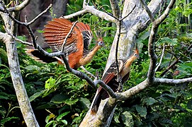
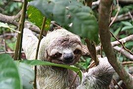
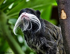
Wet tropical forests are the most species-rich biome, and tropical forests in the Americas are consistently more species rich than the wet forests in Africa and Asia.[29] As the largest tract of tropical rainforest in the Americas, the Amazonian rainforests have unparalleled biodiversity. One in ten known species in the world lives in the Amazon rainforest.[30] This constitutes the largest collection of living plants and animal species in the world.
The region is home to about 2.5 million
The biodiversity of plant species is the highest on Earth with one 2001 study finding a quarter square kilometer (62 acres) of Ecuadorian rainforest supports more than 1,100 tree species.[35] A study in 1999 found one square kilometer (247 acres) of Amazon rainforest can contain about 90,790 tonnes of living plants. The average plant biomass is estimated at 356 ± 47 tonnes per hectare.[36] To date, an estimated 438,000 species of plants of economic and social interest have been registered in the region with many more remaining to be discovered or catalogued.[37] The total number of tree species in the region is estimated at 16,000.[2]
.jpg)
The green leaf area of plants and trees in the rainforest varies by about 25% as a result of seasonal changes. Leaves expand during the dry season when sunlight is at a maximum, then undergo abscission in the cloudy wet season. These changes provide a balance of carbon between photosynthesis and respiration.[38]
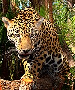
The rainforest contains several species that can pose a hazard. Among the largest predatory creatures are the
-
-

-

-

-
-
-

-
-

-
 Bullet ants have an extremely painful sting
 -
 Parrots at clay lick inYasuni National Park, Ecuador


.jpg)
.JPG)
_(9714001143).jpg)
_Edit.jpg)


.jpg)

Deforestation
_12ago2007.jpg)
In the 1970s construction began on the
Between 1991 and 2000, the total area of forest lost in the Amazon rose from 415,000 to 587,000 square kilometres (160,000 to 227,000 sq mi), with most of the lost forest becoming pasture for cattle.[46] Seventy percent of formerly forested land in the Amazon, and 91% of land deforested since 1970, is used for livestock pasture.[47][48] Currently, Brazil is the second-largest global producer of soybeans after the United States. New research however, conducted by Leydimere Oliveira et al., has shown that the more rainforest is logged in the Amazon, the less precipitation reaches the area and so the lower the yield per hectare becomes. So despite the popular perception, there has been no economical advantage for Brazil from logging rainforest zones and converting these to pastoral fields.[49]
The needs of soy farmers have been used to justify many of the controversial transportation projects that are currently developing in the Amazon. The first two highways successfully opened up the rainforest and led to increased settlement and deforestation. The mean annual deforestation rate from 2000 to 2005 (22,392 km2 or 8,646 sq mi per year) was 18% higher than in the previous five years (19,018 km2 or 7,343 sq mi per year).[50] Although deforestation has declined significantly in the Brazilian Amazon between 2004 and 2014, there has been an increase to the present day.[51]
-
 NASA satellite observation of deforestation in the Mato Grosso state of Brazil. The transformation from forest to farm is evident by the paler square shaped areas under development.
 -
 Fires and deforestation in the state of Rondônia.
 -
 One consequence of forest clearing in the Amazon: thick smoke that hangs over the forest.


Conservation and climate change
.jpg)
Environmentalists are concerned about loss of biodiversity that will result from destruction of the forest, and also about the release of the
One
In 1989, environmentalist C.M. Peters and two colleagues stated there is economic as well as biological incentive to protecting the rainforest. One hectare in the
As indigenous territories continue to be destroyed by deforestation and
From 2002 to 2006, the conserved land in the Amazon rainforest has almost tripled and deforestation rates have dropped up to 60%. About 1,000,000 square kilometres (250,000,000 acres) have been put onto some sort of conservation, which adds up to a current amount of 1,730,000 square kilometres (430,000,000 acres).[59]
-
 Anthropogenic emission of greenhouse gases broken down by sector for the year 2000.
 -
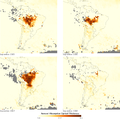 Aerosols over the Amazon each September for four burning seasons (2005 through 2008). The aerosol scale (yellow to dark reddish-brown) indicates the relative amount of particles that absorb sunlight.
 -
 Aerial roots of red mangrove on an Amazonian river.


A 2009 study found that a 4 °C rise in global temperatures by 2100 would kill 85% of the Amazon rainforest while a temperature rise of 3 °C would kill some 75% of the Amazon.[60]
Remote sensing

The use of remotely sensed data is dramatically improving conservationists' knowledge of the Amazon basin. Given the objectivity and lowered costs of satellite-based land cover analysis, it appears likely that remote sensing technology will be an integral part of assessing the extent and damage of deforestation in the basin.[61] Furthermore, remote sensing is the best and perhaps only possible way to study the Amazon on a large-scale.[62]
The use of remote sensing for the conservation of the Amazon is also being used by the indigenous tribes of the basin to protect their tribal lands from commercial interests. Using handheld GPS devices and programs like Google Earth, members of the Trio Tribe, who live in the rainforests of southern Suriname, map out their ancestral lands to help strengthen their territorial claims.[63] Currently, most tribes in the Amazon do not have clearly defined boundaries, making it easier for commercial ventures to target their territories.
To accurately map the Amazon's biomass and subsequent carbon related emissions, the classification of tree growth stages within different parts of the forest is crucial. In 2006 Tatiana Kuplich organized the trees of the Amazon into four categories: (1) mature forest, (2) regenerating forest [less than three years], (3) regenerating forest [between three and five years of regrowth], and (4) regenerating forest [eleven to eighteen years of continued development].
Impact of early 21st-century Amazon droughts
In 2005, parts of the Amazon basin experienced the worst drought in one hundred years,, with catastrophic consequences for the world's climate.
According to the World Wide Fund for Nature, the combination of climate change and deforestation increases the drying effect of dead trees that fuels forest fires.[69]
In 2010 the Amazon rainforest experienced another severe drought, in some ways more extreme than the 2005 drought. The affected region was approximate 1,160,000 square miles (3,000,000 km2) of rainforest, compared to 734,000 square miles (1,900,000 km2) in 2005. The 2010 drought had three epicenters where vegetation died off, whereas in 2005 the drought was focused on the southwestern part. The findings were published in the journal Science. In a typical year the Amazon absorbs 1.5 gigatons of carbon dioxide; during 2005 instead 5 gigatons were released and in 2010 8 gigatons were released.[70][71] Additional severe droughts occurred in 2010, 2015, and 2016.[72]
See also
- Amanyé
- Amazon Conservation Team (ACT)
- Amazonian manatee
- Amazon Surveillance System (Sistema de Vigilância da Amazônia)
- Amazon Watch
- Atlantic Forest
- Bandeirantes
- Brazilian Amazon
- Coordinator of Indigenous Organizations of the Amazon River Basin (COICA)
- List of plants of Amazon Rainforest vegetation of Brazil
- Peruvian Amazon
- Rainforest Action Network
- Rainforest Alliance
- Rainforest Foundation Fund
- Save the Amazon Rainforest Organisation (STARO)
- Tapiche Ohara's Reserve
References
- ^ "WNF: Places: Amazon". Retrieved June 4, 2016.
- ^ a b "Field Museum scientists estimate 16,000 tree species in the Amazon". Field Museum. October 17, 2013. Retrieved October 18, 2013.
- ^ ISBN 0-559-29668-1. Retrieved October 12, 2008.
- ISBN 0-471-98326-8.
- PMID 15519975.
- doi:10.1111/j.1475-5661.2005.00181.x. Archived from the original (PDF) on October 1, 2008. Retrieved September 25, 2008.)
{{cite journal}}: Unknown parameter|deadurl=ignored (|url-status=suggested) (help - ISBN 0-19-856706-5.
- .
- ^ Milani, Edison José; Zalán, Pedro Victor (1999). "An outline of the geology and petroleum systems of the Paleozoic interior basins of South America" (PDF). Episodes. 22 (3): 199–205. Archived from the original (PDF) on October 1, 2008. Retrieved September 25, 2008.
{{cite journal}}: Unknown parameter|deadurl=ignored (|url-status=suggested) (help) - ^ Colinvaux, P.A., De Oliveira, P.E. 2000. Palaeoecology and climate of the Amazon basin during the last glacial cycle. Wiley InterScience. (abstract)
- ^ Van der Hammen, T., Hooghiemstra, H.. 2002. Neogene and Quaternary history of vegetation, climate, and plant diversity in Amazonia. Elsevier Science Ltd. (abstract)
- .
- .
- ^ "Dust to gust". EurekAlert!. AAAS. 28 Dec 2006. URL accessed 2006-12-29.
- . Retrieved January 1, 2007.
- ^ NASA 2015-02-22 NASA Satellite Reveals How Much Saharan Dust Feeds Amazon's Plants
- ^ "Desert Dust Feeds Amazon Forests - NASA Science". nasa.gov.
- .
- PMID 14500979.
- PMID 14684803.
- ^ a b Chris C. Park (2003). Tropical Rainforests. Routledge. p. 108.
- ISBN 0-226-76337-4.
- ^ a b c "Unnatural Histories – Amazon". BBC Four.
{{cite web}}: Italic or bold markup not allowed in:|publisher=(help) - ^ Simon Romero (January 14, 2012). "Once Hidden by Forest, Carvings in Land Attest to Amazon's Lost World". The New York Times.
{{cite news}}: Italic or bold markup not allowed in:|publisher=(help) - .
- ^ Junior, Gonçalo (October 2008). "Amazonia lost and found". Pesquisa (ed.220). FAPESP.
- doi:10.2307/2803990.
- PMID 14500979
- ISBN 0-521-80183-4
- ^ "Amazon Rainforest, Amazon Plants, Amazon River Animals". World Wide Fund for Nature. Archived from the original on May 17, 2008. Retrieved May 6, 2008.
{{cite web}}: Unknown parameter|deadurl=ignored (|url-status=suggested) (help) - ^ "Photos / Pictures of the Amazon Rainforest". Travel.mongabay.com. Archived from the original on December 17, 2008. Retrieved December 18, 2008.
{{cite web}}: Unknown parameter|deadurl=ignored (|url-status=suggested) (help) - ^ James S. Albert; Roberto E. Reis (March 8, 2011). Historical Biogeography of Neotropical Freshwater Fishes. University of California Press. p. 308. Archived from the original on June 30, 2011. Retrieved June 28, 2011.
{{cite book}}: Unknown parameter|deadurl=ignored (|url-status=suggested) (help) - .
- .
- .
- .
- ^ "Amazon Rainforest". South AmericaTravel Guide. Archived from the original on August 12, 2008. Retrieved August 19, 2008.
{{cite web}}: Unknown parameter|deadurl=ignored (|url-status=suggested) (help) - PMID 17360360.
- ^ Staff (July 2, 2007). "Piranha 'less deadly than feared'". BBC News. Archived from the original on July 7, 2007. Retrieved July 2, 2007.
{{cite news}}: Unknown parameter|deadurl=ignored (|url-status=suggested) (help) - PMID 16965697. Archived from the original (PDF) on October 29, 2008. Retrieved October 11, 2008.)
{{cite journal}}: Unknown parameter|deadurl=ignored (|url-status=suggested) (help - ISBN 0-300-08483-8.
- .
- ^ a b Watkins and Griffiths, J. (2000). Forest Destruction and Sustainable Agriculture in the Brazilian Amazon: a Literature Review (Doctoral dissertation, The University of Reading, 2000). Dissertation Abstracts International, 15–17
- ISBN 0-226-89947-0.
- ^ Trans-Amazonian highway represented a major threat to the Amazon rainforest
- ^ Centre for International Forestry Research (CIFOR) (2004)
- ISBN 92-5-105571-8. Archived from the original on July 26, 2008. Retrieved August 19, 2008.)
{{cite book}}: Unknown parameter|deadurl=ignored (|url-status=suggested) (help - ISBN 0-8213-5691-7. Archived from the original (PDF) on September 10, 2008. Retrieved September 4, 2008.)
{{cite book}}:|work=ignored (help); Unknown parameter|deadurl=ignored (|url-status=suggested) (help - ^ Research paper of Leydimere Oliveira on the amazon Archived 2013-08-03 at archive.today
- ^ Barreto, P.; Souza Jr. C.; Noguerón, R.; Anderson, A. & Salomão, R. 2006. Human Pressure on the Brazilian Amazon Forests[permanent dead link]. Imazon. Retrieved September 28, 2006. (The Imazon web site contains many resources relating to the Brazilian Amazonia.)
- ^ "INPE: Estimativas Anuais desde 1988 até 2009". inpe.br.
- doi:10.1038/363234a0.
- ^ .
- ^ Cox, Betts, Jones, Spall and Totterdell. 2000. "Acceleration of global warming due to carbon-cycle feedbacks in a coupled climate model". Nature, November 9, 2000. (subscription required)
- ^ Radford, T. 2002. "World may be warming up even faster". The Guardian.
- Houghton, J.T. et al. 2001. "Climate Change 2001: The Scientific Basis" Archived May 7, 2006, at the Wayback Machine. Intergovernmental Panel on Climate Change.
- doi:10.1038/339655a0.
- ^ Dean, Bartholomew. (2003) State Power and Indigenous Peoples in Peruvian Amazonia: A Lost Decade, 1990–2000. In The Politics of Ethnicity Indigenous Peoples in Latin American States David Maybury-Lewis, Ed. Harvard University Press
- ^ Cormier, L. (April 16, 2006). "A Preliminary Review of Neotropical Primates in the Subsistence and Symbolism of Indigenous Lowland South American Peoples". Ecological and Environmental Anthropology. 2 (1): 14–32. Archived from the original on December 21, 2008. Retrieved September 4, 2008.
{{cite journal}}: Unknown parameter|deadurl=ignored (|url-status=suggested) (help) - ^ David Adam. "Amazon could shrink by 85% due to climate change, scientists say". the Guardian.
- doi:10.1080/01431160600928609. Archived from the original on December 21, 2008. Retrieved September 4, 2008.)
{{cite journal}}: Unknown parameter|deadurl=ignored (|url-status=suggested) (help - doi:10.1175/EI134.1.
- ^ Isaacson, Andy. 2007. With the Help of GPS, Amazonian Tribes Reclaim the Rain Forest. Wired 15.11: https://www.wired.com/science/planetearth/magazine/15-11/ps_amazon
- .
- ^ Environmental News Service – Amazon Drought Worst in 100 Years
- ^ Drought Threatens Amazon Basin – Extreme conditions felt for second year running, Paul Brown, The Guardian, 16 July 2006. Retrieved 23 August 2014
- ^ "Amazon rainforest 'could become a desert'" Archived August 6, 2006, at the Wayback Machine, The Independent, July 23, 2006. Retrieved September 28, 2006.
- ^ "Dying Forest: One year to save the Amazon", The Independent, July 23, 2006. Retrieved 23 August 2014.
- ^ "Climate change a threat to Amazon rainforest, warns WWF", World Wide Fund for Nature, March 22, 2006. Retrieved 23 August 2014.
- ^ 2010 Amazon drought record: 8 Gt extra CO2, Rolf Schuttenhelm, Bits Of Science, 4 February 2011. Retrieved 23 August 2014
- ^ "Amazon drought 'severe' in 2010, raising warming fears", BBC News, 3 February 2011. Retrieved 23 August 2014
- ^ https://www.theguardian.com/environment/climate-consensus-97-per-cent/2017/aug/03/study-finds-human-influence-in-the-amazons-third-1-in-100-year-drought-since-2005
Further reading
- Sheil, D.; Wunder, S. (2002). "The value of tropical forest to local communities: complications, caveats, and cautions". Conservation Ecology. 6 (2): 9.
{{cite journal}}: Invalid|ref=harv(help) - "Deforestation." World Geography. Columbus, Ohio: McGraw-Hill/Glencoe, 2000. 202–204
- Wade, Lizzie. (2015). "Drones and satellites spot lost civilizations in unlikely places."
External links
![]() Media related to Amazon Rainforest at Wikimedia Commons
Media related to Amazon Rainforest at Wikimedia Commons
- Journey Into Amazonia
- The Amazon: The World's Largest Rainforest
- WWF in the Amazon rainforest
- Amazonia.org.br Good daily updated Amazon information database on the web, held by Friends of The Earth – Brazilian Amazon.
- amazonia.org Sustainable Development in the Extractive Reserve of the Baixo Rio Branco – Rio Jauaperi – Brazilian Amazon.
- Amazon Rainforest News Original news updates on the Amazon.
- Amazon-Rainforest.org Information about the Amazon rainforest, its people, places of interest, and how everyone can help.
- Conference: Climate change and the fate of the Amazon. Podcasts of talks given at Oriel College, University of Oxford, March 20–22, 2007.
3°09′36″S 60°01′48″W / 3.16000°S 60.03000°W
| National | |
|---|---|
| Geographic | |