
Tyne and Wear
Tyne and Wear | |
|---|---|
The Angel of the North, Souter Lighthouse in Whitburn, and the River Tyne between Gateshead and Newcastle. | |
 Tyne and Wear within England | |
| Sovereign state | United Kingdom |
| Constituent country | England |
| Region | North East |
| Established | 1974 |
| Established by | Local Government Act 1972 |
| Preceded by |
|
UTC±00:00 (Greenwich Mean Time) | |
| • Summer (DST) | UTC+01:00 (British Summer Time) |
| Members of Parliament |
|
| Police | 16th of 48 |
| Density | 2,105/km2 (5,450/sq mi) |
| Ethnicity |
|
| Metropolitan county | |
| Area | 538 km2 (208 sq mi) |
| ONS code | 2D |
| GSS code | E11000007 |
| ITL | UKC22/23 |
| Website | tynewearlieutenancy |
| Districts | |
 Districts of Tyne and Wear | |
| Districts | |


Tyne and Wear (/ˌtaɪn ... ˈwɪər/) is a ceremonial county in North East England. It borders Northumberland to the north and County Durham to the south, and the largest settlement is the city of Newcastle upon Tyne.
The county is largely urbanised. It had a population of 1.14 million in 2021. After Newcastle (300,125) the largest settlements are the city of
The most notable geographic features of the county are the River Tyne and River Wear, after which it is named and along which its major settlements developed. The county is also notable for its coastline to the North Sea in the east, which is characterised by tall limestone cliffs and wide beaches.
History
In the late 600s and into the 700s Saint Bede lived as a monk at the monastery of St. Peter and of St. Paul writing histories of the Early Middle Ages including the Ecclesiastical History of the English People.[3]
Roughly 150 years ago, in the village of Marsden in South Shields, Souter Lighthouse was built, the first electric structure of this type.[4]
The Local Government Act 1888 constituted Newcastle upon Tyne, Gateshead and Sunderland as county boroughs (Newcastle had "county corporate" status as the "County and Town of Newcastle upon Tyne" since 1400). Tynemouth joined them in 1904. Between the county boroughs, various other settlements also formed part of the administrative counties of Durham and of Northumberland.
The need to reform local government on Tyneside was recognised by the government as early as 1935, when a Royal Commission to Investigate the Conditions of Local Government on Tyneside was appointed.[5] The three commissioners were to:
examine the system of local government in the areas of local government north and south of the river Tyne from the sea to the boundary of the Rural District of Castle Ward and Hexham in the County of Northumberland and to the Western boundary of the County of Durham, to consider what changes, if any, should be made in the existing arrangements with a view to securing greater economy and efficiency, and to make recommendations.

The report of the Royal Commission, published in 1937,[6] recommended the establishment of a Regional Council for Northumberland and Tyneside (to be called the "Northumberland Regional Council") to administer services that needed to be exercised over a wide area, with a second tier of smaller units for other local-government purposes. The second-tier units would form by amalgamating the various existing boroughs and districts. The county boroughs in the area would lose their status. Within this area, a single municipality would be formed covering the four county boroughs of Newcastle, Gateshead, Tynemouth, South Shields and other urban districts and boroughs.[7]
A minority report proposed amalgamation of Newcastle, Gateshead, Wallsend, Jarrow, Felling, Gosforth, Hebburn and Newburn into a single "county borough of Newcastle-on-Tyneside". The 1937 proposals never came into operation: local authorities could not agree on a scheme and the legislation of the time did not allow central government to compel one.[8]
Tyneside (excluding
The white paper that led to the Local Government Act 1972 proposed as "area 2" a metropolitan county including Newcastle and Sunderland, extending as far south down the coast as Seaham and Easington, and bordering "area 4" (which would become Tees Valley). The Bill as presented in November 1971 pruned back the southern edge of the area, and gave it the name "Tyneside". The name "Tyneside" proved controversial on Wearside, and a government amendment changed the name to "Tyne and Wear" at the request of Sunderland County Borough Council.[9]
| post-1974 | pre-1974 | ||||
|---|---|---|---|---|---|
| Metropolitan county | Metropolitan borough | County boroughs | Non-county boroughs | Urban districts
|
Rural districts |
 Tyne and Wear amalgamates 24 former local government districts, including five county boroughs.
|
Gateshead | Gateshead
|
- | Blaydon • Felling • Ryton • Whickham | Chester-le-Street |
| Newcastle upon Tyne | Newcastle upon Tyne
|
- | Gosforth • Newburn | Castle Ward | |
| North Tyneside | Tynemouth
|
Wallsend • Whitley Bay | Longbenton • Seaton Valley | - | |
| South Tyneside | South Shields
|
Jarrow | Boldon • Hebburn
|
- | |
| Sunderland | Sunderland
|
- | Washington • Houghton-le-Spring • Hetton-le-Hole | Easington
| |
Geography
Climate
Tyne and Wear either has or closely borders two official Met Office stations, neither located in one of the major urban centres. The locations for those are in marine Tynemouth where Tyne meets the North Sea east of Newcastle and inland Durham in County Durham around 20 kilometres (12 mi) south-west of Sunderland. There are some clear differences between the stations temperature and precipitation patterns even though both have a cool-summer and mild-winter oceanic climate.
| Climate data for Tynemouth 33 m asl, 1981–2010 | |||||||||||||
|---|---|---|---|---|---|---|---|---|---|---|---|---|---|
| Month | Jan | Feb | Mar | Apr | May | Jun | Jul | Aug | Sep | Oct | Nov | Dec | Year |
| Mean daily maximum °C (°F) | 7.2 (45.0) |
7.3 (45.1) |
9.0 (48.2) |
10.3 (50.5) |
12.7 (54.9) |
15.6 (60.1) |
18.1 (64.6) |
18.1 (64.6) |
16.1 (61.0) |
13.2 (55.8) |
9.7 (49.5) |
6.4 (43.5) |
12.1 (53.8) |
| Mean daily minimum °C (°F) | 2.2 (36.0) |
2.2 (36.0) |
3.3 (37.9) |
4.8 (40.6) |
7.2 (45.0) |
10.0 (50.0) |
12.3 (54.1) |
12.3 (54.1) |
10.4 (50.7) |
7.7 (45.9) |
4.9 (40.8) |
2.5 (36.5) |
6.7 (44.1) |
| Average precipitation mm (inches) | 45.5 (1.79) |
37.8 (1.49) |
43.9 (1.73) |
45.4 (1.79) |
43.2 (1.70) |
51.9 (2.04) |
47.6 (1.87) |
59.6 (2.35) |
53.0 (2.09) |
53.6 (2.11) |
62.8 (2.47) |
53.9 (2.12) |
597.2 (23.51) |
| Mean monthly sunshine hours | 61.1 | 81.6 | 117.7 | 149.9 | 191.7 | 183.0 | 185.7 | 174.9 | 174.1 | 106.2 | 70.4 | 51.9 | 1,515 |
| Source: Met Office[10] | |||||||||||||
| Month | Jan | Feb | Mar | Apr | May | Jun | Jul | Aug | Sep | Oct | Nov | Dec | Year |
|---|---|---|---|---|---|---|---|---|---|---|---|---|---|
| Record high °C (°F) | 16.7 (62.1) |
17.4 (63.3) |
21.7 (71.1) |
24.1 (75.4) |
27.8 (82.0) |
30.6 (87.1) |
36.9 (98.4) |
32.5 (90.5) |
30.0 (86.0) |
25.0 (77.0) |
19.4 (66.9) |
15.9 (60.6) |
36.9 (98.4) |
| Mean daily maximum °C (°F) | 6.9 (44.4) |
7.8 (46.0) |
9.9 (49.8) |
12.5 (54.5) |
15.4 (59.7) |
18.0 (64.4) |
20.2 (68.4) |
19.9 (67.8) |
17.4 (63.3) |
13.5 (56.3) |
9.7 (49.5) |
7.1 (44.8) |
13.2 (55.8) |
| Daily mean °C (°F) | 4.1 (39.4) |
4.6 (40.3) |
6.2 (43.2) |
8.3 (46.9) |
10.9 (51.6) |
13.6 (56.5) |
15.8 (60.4) |
15.6 (60.1) |
13.3 (55.9) |
10.0 (50.0) |
6.6 (43.9) |
4.2 (39.6) |
9.5 (49.1) |
| Mean daily minimum °C (°F) | 1.3 (34.3) |
1.4 (34.5) |
2.5 (36.5) |
4.1 (39.4) |
6.5 (43.7) |
9.3 (48.7) |
11.3 (52.3) |
11.3 (52.3) |
9.2 (48.6) |
6.5 (43.7) |
3.6 (38.5) |
1.4 (34.5) |
5.7 (42.3) |
| Record low °C (°F) | −17.2 (1.0) |
−18.3 (−0.9) |
−15.0 (5.0) |
−11.1 (12.0) |
−4.4 (24.1) |
−1.1 (30.0) |
1.1 (34.0) |
0.6 (33.1) |
−1.1 (30.0) |
−5.5 (22.1) |
−8.8 (16.2) |
−16.6 (2.1) |
−18.3 (−0.9) |
| Average precipitation mm (inches) | 51.8 (2.04) |
44.6 (1.76) |
41.1 (1.62) |
51.2 (2.02) |
44.4 (1.75) |
61.0 (2.40) |
60.9 (2.40) |
66.5 (2.62) |
56.9 (2.24) |
63.4 (2.50) |
73.0 (2.87) |
61.0 (2.40) |
675.7 (26.60) |
| Average precipitation days (≥ 1.0 mm) | 11.8 | 9.9 | 8.6 | 9.1 | 8.6 | 9.9 | 10.7 | 10.3 | 9.4 | 11.8 | 12.0 | 12.0 | 124.1 |
| Mean monthly sunshine hours | 60.9 | 84.4 | 121.7 | 160.8 | 187.1 | 167.1 | 174.3 | 167.3 | 135.3 | 98.9 | 64.6 | 57.6 | 1,480 |
| Source 1: Met Office[11][12][13] | |||||||||||||
| Source 2: Durham Weather UK[14] | |||||||||||||
Green belt
Tyne and Wear contains green belt interspersed throughout the county, mainly on the fringes of the Tyneside/Wearside conurbation. There is also an inter-urban line of belt helping to keep the districts of South Tyneside, Gateshead, and Sunderland separated. It was first drawn up from the 1950s. All the county's districts contain some portion of belt.
Governance
Although
Other joint bodies include the Tyne and Wear Fire and Rescue Service and Tyne & Wear Archives & Museums, which was created from the merger of the Tyne and Wear Archives Service and Tyne and Wear Museums. These joint bodies are administered by representatives of all five of the constituent councils. In addition the Northumbria Police force covers Northumberland and Tyne and Wear.
There have been occasional calls for Tyne and Wear to be abolished and the traditional border between Northumberland and County Durham to be restored.[15][16]
Tyne and Wear is divided into 12
| Labour | Liberal Democrats | Conservative | Brexit | Others | Green | Turnout |
|---|---|---|---|---|---|---|
| 247,317 |
36,417 |
160,155 |
47,142 |
10,504 |
16,010 |
517,545 |
| Labour | Liberal Democrats | Conservative | BNP | UKIP | Others | Green | |
|---|---|---|---|---|---|---|---|
| 12 | 0 | 0 | 0 | 0 | 0 | 0 |
At the level of local government, all of the region's five unitary authorities were controlled by Labour in 2019.
Newcastle and Sunderland are known for declaring their election results early on election night.[17] Therefore, they frequently give the first indication of nationwide trends. An example of this was at the 2016 European Union referendum. Newcastle was the first large city to declare, and 50.6% of voters voted to Remain; this proportion was far lower than predicted by experts. Sunderland declared soon after and gave a 62% vote to Leave, much higher than expected. These two results were seen as an early sign that the United Kingdom had voted to Leave.
Settlements

Italics indicate the district centre. For a complete list of all villages, towns and cities see the list of places in Tyne and Wear.
Education
Higher
Two campuses of
Further
- Burnside College
- ESPA College
- Gateshead College
- Harton Academy and Sixth Form
- Newcastle College
- Newcastle Sixth Form College
- Tyne Metropolitan College
- South Tyneside College
- Sunderland College
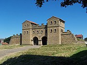
Places of interest
.jpg)
| Key | |
| Abbey/Priory/Cathedral | |
| Accessible open space | |
| Amusement/Theme Park | |
| Castle | |
| Country Park | |
| English Heritage | |
| Forestry Commission | |
| Heritage railway | |
Historic House
| |
| Places of Worship | |
| Museum (free/not free) | |
National Trust
| |
| Theatre | |
| Zoo | |
Gallery
-
 Tynemouth Priory
 -
 Arbeia Museum
 -
 Newcastle Keep
.jpg)

.jpg)
Businesses


The
The government's
See also
References
- ^ "No. 62943". The London Gazette. 13 March 2020. p. 5161.
- ^ "2011 census: Ethnic group (detailed)". Office for National Statistics. Archived from the original on 20 May 2018. Retrieved 19 May 2018.
- ^ "The Venerable Bede – England's first great historian". British Heritage. 29 October 2020. Retrieved 8 March 2021.
- ^ "Five of England's less-visited counties for days out and short breaks". Guardian. 6 March 2021. Retrieved 8 March 2021.
- ^ London Gazette, 10 May 1935
- ^ Local Government in the Tyneside Area (Cmd.5402)
- ^ Government of Tyneside : a Regional Council. The Times. 19 March 1937.
- ^ Local Government on Tyneside. Sir K. Wood and Report of Commission. The Times. 22 September 1937.
- ^ Hansard, 6 July 1972, column 909
- ^ "Tynemouth climate information". Met Office. Archived from the original on 28 April 2016. Retrieved 13 August 2015.
- ^ "Durham (Durham) UK climate averages". Met Office. 1991–2020. Retrieved 1 January 2022.
- ^ "Exceptional warmth, December 2015". Met Office. 27 January 2016. Retrieved 19 October 2017.
- ^ Kendon, Mike; McCarthy, Mark; Jevrejeva, Svetlana; Legg, Tim (2015). "State of the UK Climate 2015" (PDF). Met Office. Retrieved 29 March 2018.
- ^ "North East England Climate : Durham Weather". Durham Weather UK. Retrieved 15 July 2020.
- ^ "Call to return the county to its historic status". Northumberland Gazette. 19 March 2016.
- ^ Henderson, Tony (3 January 2019). "Are there signs that our traditional county boundaries are set to return?". Evening Chronicle.
- ^ Rodger, James (8 June 2017). "Why Sunderland and Newcastle always declare election results first". birminghammail.
- ^ "RRTEC". Rrnetc.co.uk. Archived from the original on 26 April 2012. Retrieved 12 June 2012.
External links
- Images of Tyne and Wear at the English Heritage Archive
- Tyne and Wear at Curlie
| Metropolitan districts | |
|---|---|
| Major settlements (cities in italics) |
|
| Topics | |

| National | |
|---|---|
| Geographic | |