
Santo Domingo
Santo Domingo | |
|---|---|
| Santo Domingo de Guzmán | |
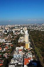
 From top to bottom, from left to right: Panoramic Image of the City, Fortaleza Ozama, Parque a Colón, Autonomous University of Santo Domingo (UASD), Obelisk of George Washington Avenue (the Malecón), The National Palace of the Dominican Republic, Las Américas International Airport. | |
|
AST (UTC −4) | |
| Postal codes | 10100–10699 (Distrito Nacional) |
| Area codes | 809, 829, 849 |
| Website | adn (in Spanish) |
| Official name | Colonial City of Santo Domingo |
| Type | Cultural |
| Criteria | ii, iv, vi |
| Designated | 1990 (14th session) |
| Reference no. | 526 |
| Region | Latin America and the Caribbean |
Santo Domingo (Spanish pronunciation:
Founded by the Spanish in 1496, on the east bank of the Ozama River and then moved by Nicolás de Ovando in 1502 to the west bank of the river, the city is the oldest continuously inhabited European settlement in the Americas, and was the first seat of the Spanish colonial rule in the New World, the Captaincy General of Santo Domingo. It is the site of the first university, cathedral, castle, monastery, and fortress in the New World. The city's Colonial Zone was declared as a World Heritage Site by UNESCO.[8][9] Santo Domingo was called Ciudad Trujillo (Spanish pronunciation: [sjuˈðað tɾuˈxiʝo]), from 1936 to 1961, after the Dominican Republic's dictator, Rafael Trujillo, named the capital after himself. Following his assassination, the city resumed its original designation.
Santo Domingo is the
History

Prior to the arrival of

Dating from 1493, when the Spanish settled on the island, and officially from August 5, 1498, Santo Domingo became the oldest European city in the Americas.


.jpg)
In June 1502,[13] Santo Domingo was destroyed by a major hurricane, and the new Governor Nicolás de Ovando had it rebuilt on a different site on the other side of the Ozama River.[14][15] The original layout of the city and a large portion of its defensive wall can still be appreciated today throughout the Colonial Zone, declared a World Heritage Site by UNESCO.
The first major
From 1795 to 1822, the city changed hands several times along with the colony it headed. It was ceded to France in 1795. The city was briefly captured by Haitian rebels in 1801, recovered by France in 1802,
On 27 February 1844, Santo Domingo was again the capital of a free nation, when it gained its independence from Haiti, led by Dominican nationalist

The city was struck by
In 1962, Juan Bosch was elected to the presidency. He was overthrown seven months later, resulting in a civil war in the capital. Francisco Caamaño led the Constitucionalistas fighting to restore democracy. This would lead to the second U.S. invasion in 1965. U.S. troops engaged in heavy fighting in the streets of Santo Domingo against the Constitucionalistas on June 15 and June 16. Newsweek described it this way:
Amid the clatter of automatic weapons, the sharp rattle of .50-caliber guns and the heavy explosions of bazookas and recoilless rifles, the paratroopers of the 82nd U.S. Airborne Division blasted their way four city blocks into Caamaño's bastion. Heavy fire from U.S. guns across the Ozama River ringed rebel headquarters on El Conde Street, shattered buildings and started huge fires.
Eventually, the fighting would end on August 31, 1965, with 2,850 Dominicans and 44 American servicemen dead.[28]
The year 1992 marked the 500th anniversary, El Quinto Centenario, of Christopher Columbus'
Geography
This section needs expansion. You can help by adding to it. (November 2022) |

The Ozama River flows 148 kilometers (92 miles) before emptying into the Caribbean Sea. Santo Domingo's position on its banks was of great importance to the city's economic development and the growth of trade during colonial times. The Ozama River is where the country's busiest port is located.
Climate
The average temperature in Santo Domingo varies little, because the
Like many other cities in the Caribbean, Santo Domingo is very susceptible to hurricanes. Hurricane Georges caused severe destruction in September 1998. The lowest recorded temperature has been 11.0 °C (51.8 °F) on 5 February 1951 and 7 January 1957 and the highest is 39.5 °C (103.1 °F) on 29 May 2002.[30]
| Climate data for Santo Domingo, Dominican Republic (1971–2000, extremes 1909–present) | |||||||||||||
|---|---|---|---|---|---|---|---|---|---|---|---|---|---|
| Month | Jan | Feb | Mar | Apr | May | Jun | Jul | Aug | Sep | Oct | Nov | Dec | Year |
| Record high °C (°F) | 34.4 (93.9) |
33.9 (93.0) |
36.0 (96.8) |
37.0 (98.6) |
39.5 (103.1) |
37.2 (99.0) |
37.8 (100.0) |
38.8 (101.8) |
36.7 (98.1) |
38.8 (101.8) |
35.0 (95.0) |
33.5 (92.3) |
39.5 (103.1) |
| Mean daily maximum °C (°F) | 29.4 (84.9) |
29.3 (84.7) |
29.6 (85.3) |
30.3 (86.5) |
30.6 (87.1) |
31.3 (88.3) |
31.7 (89.1) |
31.8 (89.2) |
31.6 (88.9) |
31.3 (88.3) |
30.8 (87.4) |
29.8 (85.6) |
30.6 (87.1) |
| Daily mean °C (°F) | 24.7 (76.5) |
24.6 (76.3) |
25.1 (77.2) |
25.8 (78.4) |
26.5 (79.7) |
27.2 (81.0) |
27.3 (81.1) |
27.4 (81.3) |
27.3 (81.1) |
26.9 (80.4) |
26.3 (79.3) |
25.2 (77.4) |
26.2 (79.2) |
| Mean daily minimum °C (°F) | 20.0 (68.0) |
19.9 (67.8) |
20.5 (68.9) |
21.4 (70.5) |
22.5 (72.5) |
23.1 (73.6) |
23.0 (73.4) |
23.0 (73.4) |
23.0 (73.4) |
22.6 (72.7) |
21.9 (71.4) |
20.6 (69.1) |
21.8 (71.2) |
| Record low °C (°F) | 11.0 (51.8) |
11.0 (51.8) |
13.3 (55.9) |
15.5 (59.9) |
16.5 (61.7) |
18.6 (65.5) |
18.2 (64.8) |
18.0 (64.4) |
18.0 (64.4) |
17.0 (62.6) |
17.0 (62.6) |
13.0 (55.4) |
11.0 (51.8) |
| Average rainfall mm (inches) | 74.5 (2.93) |
67.9 (2.67) |
61.9 (2.44) |
72.1 (2.84) |
176.6 (6.95) |
116.4 (4.58) |
131.2 (5.17) |
178.1 (7.01) |
208.7 (8.22) |
186.2 (7.33) |
132.5 (5.22) |
82.9 (3.26) |
1,489 (58.62) |
| Average rainy days (≥ 1.0 mm) | 8.3 | 6.8 | 7.0 | 6.5 | 10.5 | 9.3 | 10.8 | 11.5 | 12.1 | 12.5 | 10.7 | 9.1 | 115.1 |
| Average relative humidity (%)
|
82.0 | 81.1 | 80.1 | 79.4 | 82.2 | 82.2 | 82.2 | 83.3 | 84.0 | 84.8 | 84.0 | 82.6 | 82.3 |
| Mean monthly sunshine hours | 239.7 | 229.6 | 253.4 | 248.8 | 233.9 | 232.3 | 225.9 | 231.6 | 219.9 | 230.7 | 227.5 | 224.1 | 2,797.4 |
| Source 1: ONAMET[31] | |||||||||||||
| Source 2: Diario Libre (May record high, and record lows for January and February),[30] Meteo Climat (record highs and lows)[32] | |||||||||||||
Cityscape


Architecture

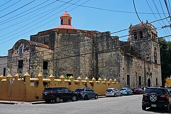
Many of Santo Domingo's most notable landmarks are located within the Zona Colonial district of the city, a UNESCO World Heritage Site since 1990. The Colonial Zone, bordered by the Río Ozama, also has a collection of early 16th century buildings, including palatial houses and majestic churches that reflect the architectural style of the late Middle Ages. The Church and Convent of los Dominicos is the oldest Catholic building in continuous use in the Americas, and was the headquarters of the first university in the Americas.[8]
The city's most important historical buildings include the
On the north end of Calle Las Damas, the restored and expanded Plaza de España is bordered by Las Atarazanas (former naval yard, now a museum) and a number of small shops and restaurants. This area was the first European commercial center in the Americas, and is still a hub of activity today. The Alcázar de Colón, having once been the colonial palace of the Columbus family – beginning with his son Diego – is now a museum displaying period furniture and decorations. The building was originally built in 1510, and restored to its current appearance in 1952.[citation needed]
A 700 million US dollar investment was made in the Port of the Ozama river adjacent to the Ciudad Colonial aiming to turn Santo Domingo into a port of call for luxury cruise ships and including a privately owned marina. The project is being completed by Sans Soucí Ports S.A.
-
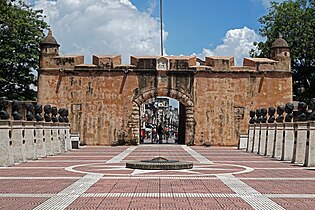 Puerta del Conde, built between 1543-1655, was the main entrance to the colonial fortified city of Santo Domingo
 -
 Gothic styleBasilica Cathedral of Santa María la Menor, was the first cathedral built in the Americas
 -
 The City Hall of Santo Domingo, building built between 1504 to the early 19th century, but its tower was built in 1913
 -
 Edificio Baquero
 -
 Edificio Cerame


Neighborhoods

The city proper of Santo Domingo is subdivided into incorporated areas (neighborhoods) called sectores which could be considered as small urban towns. All sectores are serviced directly by the municipal mayor's office.
Sector regions:
- Ciudad (city) – applies to the original older parts of town, many of which date back to the colonial times.
- Ensanche (lit. "widening") – usually, but not always, applied to the more "modern" parts of the city.
- Villa (village) – the urban outskirts of both the old city of Santo Domingo and the current (smaller) National District; originally they were separate villages, hence their names.
Government and politics

Santo Domingo is the center of the national government of the Dominican Republic. The President's office and ministries, National Congress, Supreme Court of Justice, and other main government institutions are located in the metropolitan area.
The city is administered by the Ayuntamiento del Distrito Nacional (City Hall), which is responsible for municipal functions.[33] The current mayor of Santo Domingo is Carolina Mejía de Garrigó.
The "Policía Nacional" (National Police) and "Policia Turística" (Tourist Police) (POLITUR) are tasked with enforcing city safety.
Economy
This section needs additional citations for verification. (November 2022) |

The city is the center of economic activity in the Dominican Republic. It is where most of the country's wealth is concentrated and the seat of the national legislature, judicial, and executive government. Many national and international firms have their headquarters or regional offices in Santo Domingo. The city attracts many international firms and franchises such as Ikea, Goldcorp and Barrick due to its location and economic stability.[34]
The infrastructure is suitable for most business operations. A key element that has helped the city grow and compete globally is the telecommunications infrastructure. Santo Domingo and the Dominican Republic as a whole enjoy a modern and extensive telecommunications system liberalized in the late 1990s which has benefited from extensive foreign investment. This has attracted numerous call centers in recent years. Santo Domingo not only has an excellent telecommunications infrastructure but also a sizeable bilingual population that speaks English.
The city's economic growth can be witnessed in the extensive vertical growth experienced across many of its neighborhoods. The construction boom is reflected in the many high density residential towers, shopping malls, elevated highways, the metro expansion and overall increase in commercial activity.
Santo Domingo has a thriving middle class contrasting with the significant pockets of poverty that remain as challenges for the future. Marginalized slum conditions exist mostly in the northeast quadrant of the city with smaller pockets extending across the city. Areas of extensive development include the
Santo Domingo has areas of high development, among them Serralles, Naco, Arroyo Hondo, Piantini, Urb Fernandez, Ens. Julieta, Paraiso, Los Prados, Bella Vista, Sarasota and other sectors, where most of the middle class can be found.
Bella Vista and La Esperilla are currently the fastest growing sectors with large mega -projects. Gazcue belongs to the more traditional southeastern area of the city and is known for its buildings dating from the 1930s to the 1960s.
Culture
The


Santo Domingo is the location of numerous museums, many of which are located in the Zona Colonial district.[29] In the Zona Colonial is the Museum of Alcázar, in Diego Colon's palace,[36] the Museum of the Casas Reales, with artefacts of the colonial period and a collection of ancient weapons donated by Trujillo,[37] the Naval Museum of the Atarazanas, in the former naval yards, Museo de la Catedral, Museo Memorial de la Resistencia Dominicana, documenting the struggle for freedom during the regimes of Trujillo and Balaguer, Museo Duarte, dedicated to the hero of Dominican independence, and the World of Ambar Museum.

Plaza de la Cultura also houses the city's most important cultural venues, including the
In the Plaza de la Cultura are the Museum of the Dominican Man, with artifacts from the pre-Columbian
Media and communications
Parks and recreational areas
The city has various parks, many of which are relatively large. Santo Domingo (D.N) is surrounded by the Santo Domingo Greenbelt. Mirador Norte Park lies in the north of the city, close to Villa Mella and Mirador Sur Park is located in the southwest section of the city. Mirador del Este is located on the East bank of the Ozama river and it is the seat of the Columbus Lighthouse. Independencia Park and Colón Park are located in Zona Colonial. Zoo Parque Zoológico Nacional is home to a range of 82–100 both exotic and native plants and animal species.[40]

Other notable parks include:
- Parque Enriquillo
- Parque Independencia
- Parque Metropolitano Las Praderas
- El Malecón
- Jardín Botánico Nacional
- Parque Zoológico Nacional
- Barrio Chino de Santo Domingo
- Parque Núñez de Cáceres
- Parque Iberoamérica
- Mirador Sur
Education
There are eighteen universities in Santo Domingo, the highest number of any city in the Dominican Republic. Established in 1538, the Universidad Autónoma de Santo Domingo (UASD) is the oldest university in the Americas and is also the only public university in the city.[41][42] Santo Domingo holds the nation's highest percentage of residents with a higher education degree.[citation needed]
Other universities include:
- Universidad Adventista Dominicana(UNAD)
- Universidad APEC (UNAPEC)
- Instituto Tecnológico de Santo Domingo(INTEC)
- Universidad del Caribe (UNICARIBE)
- Universidad Iberoamericana (UNIBE) (UNIBE)
- Universidad Católica Santo Domingo (UCSD)
- Universidad de la Tercera Edad (UTE)
- Universidad Tecnológica de Santiago (UTESA)
- Universidad Nacional Pedro Henríquez Ureña (UNPHU)
- Instituto de Ciencias Exactas (INCE)
- Universidad Organización y Método(O&M)
- Universidad Interamericana (UNICA)
- Universidad Eugenio María de Hostos (UNIREMOS)
- Universidad Francisco Henríquez y Carvajal(UFHEC)
- Universidad Instituto Cultural Domínico Americano (UNICDA)
- Pontificia Universidad Católica Madre y Maestra (PUCMM)
- Universidad de Psicologia Industrial Dominicana (UPID)
Transportation
This section needs additional citations for verification. (November 2022) |

Santo Domingo has an underground and elevated
In 2018, a 5-kilometer Teleférico de Santo Domingo (aerial cable car) was opened to provide service to the poorest areas in the east and north of the metropolitan area, and serve as a feeder for the metro. The cable car is used by more than 12,000 people daily.[45]
Santo Domingo is served by two airports.
The Port of Santo Domingo is located on the Ozama River. Its location at the center of the Caribbean is well suited for flexible itinerary planning and has excellent support, road and airport infrastructure within the Santo Domingo region, which facilitate access and transfers. The port is suitable for both turnaround and transit calls.
The port's renovation is part of a major redevelopment project, aimed at integrating the port area and the Zona Colonial and foster a cruise, yacht, and high-end tourism destination. Supported by legislation approved in 2005, the project, developed by the Sans Souci Group, also includes the development of a new sports marina and a 122-acre (0.49 km2) mixed-leisure real estate development adjacent to the port.
Santo Domingo is the terminus for four of the
Main avenues
prose. is available. (November 2022) |
Expreso John F. Kennedy: This expressway crosses the National District from east to west in the north-central part. The Avenue consists of a total of ten lanes, five on each side. The two center lanes of the road are express lanes to facilitate transit. It also has several bypasses and elevated crossings.

Avenida 27 de Febrero: It is the main avenue to cross the National District from east to west in the central part of Santo Domingo. It starts at the Juan Bosch bridge and crosses the entire city until the roundabout at the Plaza de la Bandera, which extends into the town of Santo Domingo West and ends on the Duarte Highway. The thoroughfare is composed of a total of ten lanes. Five on each side. The four lanes in the center of the avenue are express that facilitate transit in the city from east to west, with several elevated cross streets, overpasses and tunnels. It also has exclusive bus lanes.
Avenida Simón Bolívar: It extends from Independence Park to the junction with the Avenue Winston Churchill. In its entirety, this avenue is composed of two local lanes one-way east- west.
Avenida Independencia: It extends from the intersection with Avenida Gregorio Luperón to Independence Park. The avenue consists of a total of four lanes (two eastbound and two westbound ) from crossing with Av G. Luperon to the intersection of Avenida Italia . From the junction with Av Italy until Independence Park Avenue becomes one-way eastbound and contains only two lanes.
Avenida George Washington: It is colloquially referred as "El Malecón" This is Santo Domingo's Maritime Boulevard, running alongside the Caribbean sea's waterfront. It extends from Palo Hincado Street to the intersection with Abraham Lincoln Avenue; from that point to the Haina River Highway 30 May extends also includes President Billini Walk, which starts in Palo Hincado street and joins the Avenida del Puerto along the western bank of the Ozama River. Throughout its entire length it is composed of four lanes (two on each side). On this Boulevard you will find the most exclusive hotels in the city, several casinos, the mixed business and residential high rise complex Malecón Center, the Obelisk and Eugenio María de Hostos' Park. This is also the Boulevard where the Santo Domingo Carnival parade takes place.
Avenida Winston Churchill: It extends from Kennedy Avenue to Avenida 27 de Febrero, from there on, it continues as Avenida Jimenez Moya to reach the Centro de los Heroes and finally the boardwalk. This thoroughfare is distinguished by its date palms that are planted on the sidewalks . Throughout its length the road is composed of six lanes (three on each side) and a large wooded median popularly known as Boulevard de la Churchill ("Churchill's Boulevard") and within this lies the Boulevard of the Stars.
Avenida Abraham Lincoln: extends from Avenida Kennedy to the seawall. The route consists of six lanes (three on each side) and a median suitable for jogging laid with palm trees. It traverses the city's commercial and leisure city center.
Avenida José Ortega y Gasset: It extends from the Paseo de los Reyes Católicos Avenue until 27 de Febrero. The avenue consists of four lanes, two on each side. Along this avenue lies the Centro Olímpico Juan Pablo Duarte athletic complex and the Hospital General de la Plaza de la Salud medical complex.
Avenida Tiradentes: It extends from the jetty in the south, through the state's university Universidad Autónoma de Santo Domingo. It extends to the north along Avenida 27 de Febrero, John F. Kennedy, and continuing north past the city's baseball stadium Estadio Quisqueya until it reaches the Parque Zoológico Nacional National Zoo.
Avenida Gregorio Luperón: It extends from Kennedy Avenue to Highway 30 May on the western edge of Santo Domingo. The thoroughfare consists of eight lanes, four on each side and a landscaped median. Local attractions located on this strip includes Gallístico Center Herrera Industrial Zone, and the Plaza de la Bandera.
Avenida Máximo Gómez y Báez: The city's main south–north avenue, it extends from the Malecón to the Presidente Peynado bridge. The boulevard consists of four lanes, two on each side. Major buildings and points of interest along this boulevard are: the National Cemetery, Plaza de la Cultura which houses the National Theatre and the Palace of Fine Arts. There are also two universities (UNAPEC and UTESA), as well as the headquarters of the People's Bank and five star hotel "Hotel Barceló Santo Domingo".
Avenida Juan Pablo Duarte: It extends from the intersection of Avenida Paseo and Martyrs of the Catholic Monarchs to Calle Padre Billini in the Colonial Zone . The avenue consists of three lanes on a road north–south direction becomes one lane to enter the Colonial Zone . This avenue is the main commerce route for low-income people throughout the metropolitan area with department stores, restaurants, and shops that offer goods and services at modest prices . In "Duarte" (as popularly known) you can find the New Market, the Enriquillo Park, Duarte Commercial Square and Santo Domingo's Chinatown.
Avenida Nicolás de Ovando y Cáceres: Is located on the northern part of Santo Domingo starting at the roundabout Cristo Rey sector and corner with Ortega y Gasset, Máximo Gómez, Arbert Duarte and Thomas avenues, among others; culminating in the sector of Simón Bolívar . This avenue is characterized by many businesses that sell auto parts .
Sports
prose. is available. (November 2022) |
Baseball

Baseball is the most popular sport in the country, and was introduced by the United States Marines. Santo Domingo is home to two of the six teams in the Dominican Professional Baseball League.
- Tigres del Licey, founded in 1907, have won 24 national championships since 1951. It is the most senior national team, winning 11 Caribbean Series titles as well.
- Leones del Escogido, founded in 1921, are winners of 16 national championships since 1951. It is the third team with the most championships won. The team has 4 titles won in the Caribbean Series.
These two teams are based in the Estadio Quisqueya located in Ensanche La Fe. In 2007 The stadium underwent a rebuilding job which expanded its number of seats and the overall look of the field. The bullpens are now enclosed and out of play. Former president Leonel Fernández also announced in 2009 that there are plans to turn the stadium and the adjacent area into a modern sports complex.
Basketball
Santo Domingo's Basketball Tournament Superior is held in the National District each year, with several teams participating and representing several sectors and social clubs of the city.
Some of the teams participating in the tournament include:
|
|
The city hosted the 2005 FIBA Americas Championship, which was played at the Palacio de los Deportes Virgilio Travieso Soto.
Sports clubs
|
|
International relations
This section needs additional citations for verification. (February 2015) |
Twin towns – Sister cities
Santo Domingo is
 Bogotá, Colombia
 Buenos Aires, Argentina
 Caracas, Venezuela
 Catbalogan, Philippines
 Curitiba, Brazil[46]
 Guadalajara, Mexico[47]
 Haifa, Israel
 Havana, Cuba[46]
 La Muela, Spain[46]
- Madrid, Spain[48]
- Manaus, Brazil (2009)[49]
 Paris, France
- Pontevedra, Spain[50]
 Providence, Rhode Island, United States[46]
- Rosario, Argentina[51]
 Quito, Ecuador
- Santa Cruz de Tenerife, Spain
- Santiago, Philippines
 Taipei, Taiwan
 Seoul, South Korea
- Busan, South Korea
Santo Domingo has four
|
Gallery
-
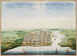 Santo Domingo city as depicted by Johannes Vingboons in 1665. Nationaal Archief.
 -
 Edificio Diez
 -
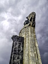 Statue of Antonio de Montesinos
 -
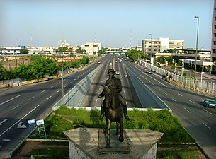 John F. Kennedy Avenue, Santo Domingo
 -
 Santo Domingo at night
 -
 Anacaona Avenue in Santo Domingo. Mirador del Sur park
 -
-
 National pantheon
 -
 Calle Arzobispo Meriño


People from Santo Domingo
Famous Dominican singer Juan Luis Guerra-Seijas was born on June 7, 1957, in the capital city, Santo Domingo.[54]
See also
- List of colonial buildings in Santo Domingo
- Ciudad Colonial (Santo Domingo)
- List of oldest buildings in the Americas
- History of the Dominican Republic
- List of cities in the Dominican Republic
- Culture of the Dominican Republic
- Index of Dominican Republic-related articles
- List of cities in the Caribbean
Notes
- ^ The metro area is defined as the municipalities belonging to the Commonwealth of the Greater Santo Domingo (Mancomunidad del Gran Santo Domingo).
These municipalities are: Distrito Nacional, Santo Domingo Este, Santo Domingo Norte, Santo Domingo Oeste, Los Alcarrizos, Boca Chica, Pedro Brand, San Antonio de Guerra, San Cristóbal, Bajos de Haina, and San Gregorio de Nigua.[4] - ^ The English troops withdrew and took the less guarded colony of Jamaica instead.[20]
References
- ^ "Provincias Dominicanas" (PDF). Retrieved 18 September 2023.
- ^ (in Spanish) Superficies a nivel de municipios, Oficina Nacional de Estadística Archived 17 November 2014 at the Wayback Machine
- ^ De la Fuente, Santiago (1976). Geografía Dominicana (in Spanish). Santo Domingo, Dominican Republic: Editora Colegial Quisqueyana.
- ^ "Carlos Guzmán es electo como presidente de la Mancomunidad del gran Santo Domingo" (in Spanish). Ayuntamiento de Santo Domingo Norte. Retrieved 1 February 2024.
- ^ "Informe básico XCPV". Retrieved 1 February 2024.
- ^ "TelluBase—Dominican Rep. Fact Sheet (Tellusant Public Service Series)" (PDF). Tellusant. Retrieved 11 January 2024.
- ^ Bourne, Kevin. "Local government in the Caribbean". City Mayors. Archived from the original on 6 April 2023.
- ^ a b c d "Colonial City of Santo Domingo". UNESCO World Heritage Centre. Archived from the original on 3 March 2024.
- ^ Comisiones Nacionales: UNESCO
- ISBN 978-1-4633-1368-5. Retrieved 4 June 2012.
- ISBN 978-0-8239-3627-4. Retrieved 4 June 2012.
- ]
- ISBN 978-1-4051-9427-3. Retrieved 4 June 2012.
- ^ Meining 1986:9
- ^ a b Floyd, Troy (1973). The Columbus Dynasty in the Caribbean, 1492–1526. Albuquerque: University of New Mexico Press. pp. 55, 73.
- ^ "Diego de Medrano | Real Academia de la Historia". dbe.rah.es. Retrieved 3 February 2024.
- ^ a b "Dominican Republic – THE FIRST COLONY". Library of Congress. Retrieved 18 March 2009.
- ^ Public Record Office, SP 12/189, 42, letter of Nicholas Clever to Nicholas Turner, merchant, 26 May 1586.
- ISBN 9780820311036.
- ISBN 9780874368376.
- ^ Bradley, Peter T. British Maritime Enterprise in the New World: From the Late Fifteenth to the Mid-eighteenth Century. p. 152.
- ^ Ricourt, Milagros (2016). The Dominican Racial Imaginary: Surveying the Landscape of Race and Nation in Hispaniola. Rutgers University Press. p. 57.
- University of California-San Diego. Retrieved 18 March 2009.
- ^ Mary Louise Pratt, Imperial Eyes, 2007, p. 70
- ^ "City street map of Santo Domingo at www.colonialzone-dr.com" (PDF). Retrieved 20 March 2009.
- ^ "Dominican Republic (1902–present)".
- ISBN 978-0-8223-4482-7. Retrieved 4 June 2012.
- ISBN 9780813150024.
- ^ a b "Secretaría de Estado de Cultura". Retrieved 18 March 2009.
- ^ a b Mejía, Mariela (7 January 2011). "Frío extremo, calor agobiante" (in Spanish). Diario Libre. Archived from the original on 4 November 2013. Retrieved 2 May 2017.
- ^ "Datos climatológicos normales y extremos 71–2000 estaciones Sinópticas – tercer trimestre 2019" (in Spanish). Oficina Nacional de Meteorología. Archived from the original on 21 December 2019. Retrieved 20 December 2019.
- ^ "Station Santo Domingo" (in French). Meteo Climat. Retrieved 2 May 2017.
- ISBN 978-0-87070-775-9. Retrieved 4 June 2012.
- ^ "Country and Lending Groups". Archived from the original on 24 May 2008. Retrieved 11 June 2015.
- ^ "ALCAZAR DE COLON, COLONIAL CITY OF SANTO DOMINGO". dehovi.com.
- ISBN 978-1-74104-292-4. Retrieved 4 June 2012.
- ISBN 978-1-4053-6102-6. Retrieved 4 June 2012.
- ISBN 978-1-85828-811-6. Retrieved 4 June 2012.
- ^ "List Of Television stations in Santo Domingo | SmartScrapers". SmartScraper. Retrieved 29 March 2024.
- ^ "Animals in Dominican Republic: List, Facts, Endangered Species, and Pictures". AZ Animals. Retrieved 17 February 2022.
- ISBN 978-0-7614-1610-4. Retrieved 4 June 2012.
- ISBN 978-0-7425-0005-1. Retrieved 4 June 2012.
- ^ See List of metro systems
- ^ "Estadísticas de peaje y tiempo de recorrido al 2013" [Statistics of tolls and times of route 2013] (PDF). Oficina para el Reordenamiento de Transporte (OPRET) (in Spanish). p. 2. Archived from the original (PDF) on 4 March 2016. Retrieved 17 September 2013.
- ^ "Metro de Santo Domingo establece récord en transporte de pasajeros en el 2018; Metro y Teleférico montan más de 89 millones usuarios". Armario Libre (in Spanish). Santo Domingo. 7 January 2019. Retrieved 23 January 2019.[permanent dead link]
- ^ a b c d "Memoria Anual, Agosto 2002-Agosto 2003" (PDF). Ayuntamiento del Distrito Nacional. pp. 66–67. Archived from the original (PDF) on 19 August 2008. Retrieved 23 July 2008.
- ^ "Sister Cities, Public Relations". Guadalajara municipal government. Archived from the original on 2 March 2012. Retrieved 12 March 2013.
- ^ "Mapa Mundi de las ciudades hermanadas". Ayuntamiento de Madrid. Retrieved 23 July 2008.
- ^ "Universidade norte-americana fará parceria com a Câmara Municipal de Manaus". Jusbrasil.com. Archived from the original on 21 July 2011. Retrieved 4 June 2012.
- ^ La Guardia y Santo Domingo, dos ciudades hermanas (Spanish) Archived 20 December 2008 at the Wayback Machine
- ^ "Town Twinning Agreements". Municipalidad de Rosario – Buenos Aires 711. Archived from the original on 19 March 2015. Retrieved 14 October 2014.
- ^ a b c d Online Directory: Dominican Republic, Caribbean Sister Cities International, Inc. (SCI) Archived 17 September 2008 at the Wayback Machine
- ^ "NYC's Partner Cities". The City of New York. Archived from the original on 14 August 2013. Retrieved 16 December 2012.
- ^ "Why Is Juan Luis Guerra The Best-Known Dominican Musician?". LiveAbout. Retrieved 17 February 2022.
Bibliography
- ISBN 0-300-03882-8
- Santo Domingo; Fragmentos De Patria by Banreservas ISBN 99934-898-1-6
External links
 Santo Domingo travel guide from Wikivoyage
| ||
| International | |
|---|---|
| National | |
| Geographic | |
| Other | |