
South Ferry/Whitehall Street station
South Ferry/Whitehall Street | |||||||||||||
|---|---|---|---|---|---|---|---|---|---|---|---|---|---|
| Other information | |||||||||||||
| Opened | March 16, 2009 | ||||||||||||
| Accessible | |||||||||||||
| Traffic | |||||||||||||
| 2023 | 5,995,305[2] | ||||||||||||
| Rank | 36 out of 423[2] | ||||||||||||
| |||||||||||||
| |||||||||||||
| |||||||||||||


The South Ferry/Whitehall Street station is a
The complex originally consisted of three separate stations. In 1905, the Interborough Rapid Transit Company (IRT) opened a balloon loop at South Ferry, serving the IRT Broadway–Seventh Avenue and IRT Lexington Avenue Lines. The Brooklyn–Manhattan Transit Corporation (BMT) opened its station at Whitehall Street in 1918. The same year, the IRT opened a second loop for the IRT Lexington Avenue Line on the inside of the existing loop; the two loop stations were not connected to each other nor to the BMT station. Despite their proximity, the stations remained separate for 91 years.
In the early 2000s, as part of the recovery effort from the September 11, 2001, attacks, a new South Ferry terminal for the Broadway–Seventh Avenue Line was proposed. That station opened in 2009, replacing the loop station and providing a connection between the Broadway–Seventh Avenue Line's 1 train and the Broadway Line's N, R, and W trains. The new terminal for the Broadway–Seventh Avenue Line was severely damaged during Hurricane Sandy in 2012, and the MTA temporarily re-opened the loop station between 2013 and 2017, adding a temporary connection between the IRT Broadway–Seventh Avenue Line's loop and the BMT Broadway Line's platforms. The newer terminal reopened in June 2017 following extensive renovations and waterproofing work.
This station complex is the third on the site to bear the name South Ferry.
History
Original IRT station
Construction and opening
Planning for a subway line in New York City dates to 1864.[4]: 21 However, development of what would become the city's first subway line did not start until 1894, when the New York State Legislature authorized the Rapid Transit Act.[4]: 139–161 The subway plans were drawn up by a team of engineers led by William Barclay Parsons, chief engineer of the Rapid Transit Commission.[5]: 3 The Rapid Transit Construction Company, organized by John B. McDonald and funded by August Belmont Jr., signed the initial Contract 1 with the Rapid Transit Commission in February 1900,[6] in which it would construct the subway and maintain a 50-year operating lease from the opening of the line.[4]: 165 In 1901, the firm of Heins & LaFarge was hired to design the underground stations.[5]: 4 Belmont incorporated the Interborough Rapid Transit Company (IRT) in April 1902 to operate the subway.[4]: 162–191
Several days after Contract 1 was signed, the Board of Rapid Transit Railroad Commissioners instructed Parsons to evaluate the feasibility of extending the subway south to South Ferry, and then to Brooklyn. On January 24, 1901, the Board adopted a route that would extend the subway from City Hall to the Long Island Rail Road (LIRR)'s Flatbush Avenue terminal station (now known as Atlantic Terminal) in Brooklyn, via the Joralemon Street Tunnel under the East River.[7]: 83–84 [8]: 260–261 Contract 2, giving a lease of 35 years, was executed between the commission and the Rapid Transit Construction Company on September 11, 1902.[4]: 162–191 Construction began at State Street in Manhattan on November 8, 1902.[9]
The South Ferry loop was built as part of subsection 2 of Contract 2 and was largely constructed as an open trench.[10]: 102 Contractors installed a waterproof membrane and operated pumps continuously to prevent the loop from being inundated by water from New York Harbor.[11] Battery Park was only 5 to 7 feet (1.5 to 2.1 m) above mean high water, while the South Ferry station, 23 feet (7.0 m) below, was as much as 17 feet (5.2 m) beneath mean high water. Because Battery Park had been created largely through land reclamation, workers found skulls, copper coins, logs, and remnants of brick piers when they were excavating the station's site.[10]: 102–103 A temporary trestle was built to allow workers to remove dirt onto barges.[10]: 103 [11]
On July 10, 1905, the outer South Ferry platform opened; the inner track existed when the station was built, but only as a storage track. There was as yet no IRT service to Brooklyn, and all trains terminated at South Ferry's outer-loop platform.[12][13] The Joralemon Street Tunnel opened in 1908,[14] and all rush-hour trains started operating to Brooklyn the next year.[15] To address overcrowding, in 1909, the New York Public Service Commission proposed lengthening platforms at stations along the original IRT subway.[16]: 168 As part of a modification to the IRT's construction contracts, made on January 18, 1910, the company was to lengthen station platforms to accommodate ten-car express and six-car local trains.[17]: 15 The South Ferry station was not lengthened, but the platforms at other stations were extended,[17]: 106 and six-car local trains began operating in October 1910.[16]: 168 On January 23, 1911, ten-car express trains began running on the Lenox Avenue Line, and the following day, ten-car express trains were inaugurated on the West Side Line.[16]: 168 [18]
Dual System
The
Before the Dual Contracts were signed, the Public Service Commission had tentatively planned a subway line under Seventh Avenue. Because the route had not yet been assigned to the IRT, the plans for the Seventh Avenue subway had called for a second loop under Battery Park, stretching under Pier A and Castle Clinton, as well as a subway yard beneath Battery Park.[23] When the Dual Contracts were finalized, the IRT revised the plans so the Seventh Avenue Line instead connected with the existing line's outer loop.[24] The tunnel slightly underpinned a structure owned by the Chesebrough Manufacturing Company, which in July 1914 sued to prevent the tunnel from being built.[23][25] During the line's construction, the contractor discovered an ancient cannon and two cannon balls under Battery Park.[26] The Broadway–Seventh Avenue Line extension was nearly complete by late 1917, but the line did not have signals or electricity because of World War I-related delays.[27]
The Broadway–Seventh Avenue Line was extended to South Ferry on July 1, 1918. The inner-loop platform opened the same year, serving trains on the Lexington Avenue Line.[28][29] The IRT operated the South Ferry station until June 12, 1940, when the city government took over the IRT's operations.[30][31]
Originally, only the end doors of each car of a five-car train could platform at the station, because of the large gap between the middle doors and the platform, owing to the severe curve of the station. This problem was remedied in January 1959 when gap fillers were installed. On February 10, 1959, the New York City Transit Authority approved a $185,000 project to renovate the station. The project would take a year to be completed. The project would remove change booths and turnstiles from platform level to provide more space on the platform and reduce congestion. They would be relocated to a new street-level station house that would be built out of terra cotta, aluminum, glass, and stainless steel. The doors of the new entrance would be connected with the ferry house ramp with a wide stairway. The structure would be designed to fit in with the Staten Island Ferry terminal.[32] Work got underway on the project later in 1959.[33]
BMT station
Also planned under the Dual Contracts was the
When the Whitehall Street station opened on September 20, 1918, it was the southern terminal of the Broadway Line.[41][42] An additional entrance at the southern end of the station opened in November 1919, providing a direct connection to the Whitehall Terminal of the Staten Island Ferry.[43][44] The line was extended south in 1920 when the Montague Street Tunnel opened.[45] The station's platforms originally could only fit six 67-foot-long (20 m) cars. In 1926, the New York City Board of Transportation received bids for the lengthening of platforms at nine stations on the Broadway Line, including the Whitehall Street station, to accommodate eight-car trains. Edwards & Flood submitted a low bid of $101,775 for the project.[46] The platform-lengthening project was completed in 1927, bringing the length of the platforms to 535 feet (163 m).[47][48]
The city government took over the BMT's operations on June 1, 1940.
Transfer and new IRT station
Planning
On September 11, 2001,
Money was allocated for the new station's construction in 2003.[60]: 69 The station was originally budgeted at $400 million, most of which came from a Federal Transit Administration grant that had been earmarked for the World Trade Center's reconstruction.[61] Initially, neighborhood groups opposed the station's construction because of the high cost and low perceived time savings.[62] The MTA contemplated extending the existing outer loop to fit 10-car trains.[63] Community leaders acquiesced after being told that some of the money was going to be used to renovate Battery Park,[64] and the South Ferry Terminal Project was allowed to proceed.[65]: slide 2 (p. 1) New York State Assembly speaker Sheldon Silver expressed opposition to the new South Ferry station, prompting U.S. representative Vito Fossella to announce that he would block funding for the Second Avenue Subway (which Silver supported) unless Silver dropped his opposition to the new terminal.[66][67] Silver eventually agreed to drop his opposition if funding was provided for Battery Park's renovation, and federal, state, and city officials reached an agreement in June 2004.[68][69]
The FTA issued a Finding of No Significant Impact on August 30, 2004.[70]: PDF p. 1 During planning, the FTA evaluated several alternatives, including extending the existing loop platform northward; building the terminal with an extra track and platform; building a two-track terminal underneath the loop; building a two-track terminal directly under Water Street, to the east; building a two-track terminal along the waterfront under South Street, to the southeast; building a three-track terminal below the BMT Broadway Line's Whitehall Street station, under the namesake street; and building the terminal diagonally under Peter Minuit Plaza. Of these seven options, the last one was chosen because any other alternative would have been either too expensive or logistically infeasible.[70]: 3–4 (PDF p. 4–5)
Construction and opening
Construction of the station commenced in February 2005.[71] The project was split up into three parts: construction of bellmouths, a fan plant, and track junctions from the existing line; approach tunnels to the station; and the station itself.[53]: 1–8 (PDF p. 8) The bellmouths' construction would require that 270 feet (82 m) of the original tunnel would have to be rebuilt to accommodate the new junction. The fan plant, located to the east of the existing line, would facilitate ventilation from the new deep-level station, which would be located below three existing subway lines (the loop platform, the IRT Lexington Avenue Line's Joralemon Street Tunnel, and the BMT Broadway Line's Montague Street Tunnel).[53]: 1-8 to 1-9 (PDF p. 8–9) The two new approach tunnels would be single-track tunnels connecting to a cavern where a double crossover switch would be installed.[53]: 1–9 (PDF p. 9) The new 76,820-square-foot (7,137 m2) station, located at a depth of 50 feet (15 m), would contain a 600-by-25-foot (182.9 by 7.6 m) platform, a new mezzanine level, escalators, and an elevator.[53]: 1-9 to 1-10 (PDF p. 9–10) The station would also contain three exits, as well as a modern air-conditioning system, which most existing stations lacked.[71]

In late 2005, New York City authorities announced that builders working on the new station had found the remains of a stone wall from the British colonial era, during the late 17th or 18th century.
In December 2008, news sources reported that the new station was essentially finished.
Post–Hurricane Sandy

On October 29, 2012, the new IRT station suffered extensive flood damage during
The MTA initially did not consider reopening the old IRT outer loop, saying that it no longer owned the station, that the platform was inaccessible, and that the only exits had been "halved to allow for an employee facility".[96] After advocacy from Staten Island residents,[96] the MTA indicated it would reopen the old outer loop.[92] In March 2013, the MTA confirmed that the outer loop would be reopened.[97][98] The 1 train's terminal was moved back to Rector Street until the old loop station could be put back into service.[92] The outer loop reopened on April 4, 2013, and a new connection was built between the outer loop and the Broadway Line platforms.[89][99][100] This connection necessitated the temporary removal of a 20-foot (6.1 m) section of the artwork See it split, see it change, which had been installed at the station in 2009.[101] The outer loop was the first permanently-closed subway station in the MTA's history to have been reopened.[97]
The new IRT station underwent renovations, signal room relocations, and extensive waterproofing work.[102][91] The $194 million contract was awarded in November 2014 to Judlau Contracting,[103]: 39 and the new IRT station underwent extensive reconstruction, including the sealing of vents, manholes, hatches, conduits, and ducts, and the cleaning up of the station.[103]: 39 [91] The project included the installation of retractable floodgates at the complex's exits and entrances.[104][105] These improvements necessitated the closure of the station complex's main entrance for nine months starting in October 2015.[106][107] The signage and lighting fixtures were also modified, and the "South Ferry" signs on the trackside walls were enlarged.[108] The renovation cost $345 million.[103]: 39 [102] The station reopened on June 27, 2017, four years and eight months after Hurricane Sandy.[109][110][111]
Service history
IRT stations
The South Ferry outer loop was the first to open. When it was completed in 1905, the outer loop was served by local and express trains along both the West Side (now the Broadway–Seventh Avenue Line to
The IRT's original line was divided into an H-shaped system in 1918. The first part of the "H" system to open was the Broadway–Seventh Avenue Line, which was extended down to South Ferry on July 1, 1918.
After 1959, all 1 trains became local, while 3 trains stopped serving the station, instead making express stops on the Broadway–Seventh Avenue Line and using the
In April 1988,
BMT station
The Whitehall Street station opened in 1918 as the southern terminal for Broadway Line local trains.
The opening of the
When the Manhattan Bridge reopened in February 2004, the R train began serving the station at all times except late nights, while the N train only served the station at night.[143][144] In addition, weekday W trains to Ditmars Boulevard used the Whitehall Street station as their southern terminus[143][144] until that route was discontinued in June 2010.[145][146] When the Montague Street Tunnel closed for repairs in August 2013, weekday R service was divided into two segments; the Whitehall Street station was the southern terminus of the Manhattan-Queens segment.[133] The R train did not serve the station on weekends, and the N train did not stop there at all, until regular service resumed in September 2014.[147] The W train was restored in 2016,[145][146] and late-night R trains to Brooklyn began using the Whitehall Street station as their northern terminal.[148]
Station layout
| Ground | Street level | Exit/entrance Elevator at southwest corner of Whitehall and State Streets. Note: Elevator out of service |
| Mezzanine South Ferry loops |
Side platform, not in service | |
| Separating wall | ||
| Inner loop | | |
| Outer loop | No regular service (Rector Street/Greenwich or Bowling Green) → | |
| Side platform, not in service | ||
| Mezzanine | Fare control, station agent, MetroCard machines, passageway between platforms | |
| Landing | Broadway Line escalator landing | |
| Broadway platforms | Northbound | ← ← ← |
| Island platform | ||
| Center track | ← | |
| Island platform | ||
| Southbound | | |
| Broadway–Seventh Ave. platform | ||
| Track 4 | ← | |
| Island platform | ||
| Track 1 | ← | |
The complex is composed of two formerly separate stations: South Ferry and Whitehall Street. The South Ferry station on the IRT Broadway–Seventh Avenue Line runs underneath Battery Park and
The Whitehall Street portion of the complex is underneath the original portion of Manhattan Island before
Exits

Entrances and exits are located at the following places:
- Two staircases at the west side of Whitehall and Stone Streets, east of the Alexander Hamilton U.S. Custom House (National Museum of the American Indian)[151]
- One staircase at the northeast corner of Whitehall and Stone Streets[151]
- Two staircases at the southwest corner of Whitehall and Water Streets[151]
 One set of staircase/escalators and one elevator northwest of the Whitehall Terminal[151]
- One set of staircase/escalator outside of the bus stop at the southeast corner of Water and State Streets[151]
- One staircase on the southwest side of State Street, south of the intersection with Pearl Street[151]
Lower Manhattan transit | ||||||||||||||||||||||||||||||||||||||||||||||||||||||||||||||||||||||||||||||||||||||||||||||||||
|---|---|---|---|---|---|---|---|---|---|---|---|---|---|---|---|---|---|---|---|---|---|---|---|---|---|---|---|---|---|---|---|---|---|---|---|---|---|---|---|---|---|---|---|---|---|---|---|---|---|---|---|---|---|---|---|---|---|---|---|---|---|---|---|---|---|---|---|---|---|---|---|---|---|---|---|---|---|---|---|---|---|---|---|---|---|---|---|---|---|---|---|---|---|---|---|---|---|---|
| ||||||||||||||||||||||||||||||||||||||||||||||||||||||||||||||||||||||||||||||||||||||||||||||||||
IRT Broadway–Seventh Avenue Line platforms
There are two separate stations on the IRT Broadway–Seventh Avenue Line, which are individually named the South Ferry station due to their connection to Manhattan's South Ferry. The name “South Ferry loops” is used for the old South Ferry platforms, while the newer platforms are called New South Ferry. The newer island platform station was first used by the Broadway–Seventh Avenue Line's 1 service from 2009[152] to 2012 until it was damaged by Hurricane Sandy,[89] and was again placed into use in 2017.[109][110][111] The outer loop platform was reopened on April 4, 2013, to provide temporary replacement service,[89][99][100] and closed again in 2017 when the newer station reopened.[109][110][111]
Old South Ferry station (1905–2009, 2013–2017)
South Ferry | ||||||||||||||||||||||||||||||||||||||||||||||||||||||||||||||||||||||||||||||||||||||||||||||||||||||||||||||||||||||||||||||||||||||||||||||||||||||||||||||||||||||||||||||||||||||
|---|---|---|---|---|---|---|---|---|---|---|---|---|---|---|---|---|---|---|---|---|---|---|---|---|---|---|---|---|---|---|---|---|---|---|---|---|---|---|---|---|---|---|---|---|---|---|---|---|---|---|---|---|---|---|---|---|---|---|---|---|---|---|---|---|---|---|---|---|---|---|---|---|---|---|---|---|---|---|---|---|---|---|---|---|---|---|---|---|---|---|---|---|---|---|---|---|---|---|---|---|---|---|---|---|---|---|---|---|---|---|---|---|---|---|---|---|---|---|---|---|---|---|---|---|---|---|---|---|---|---|---|---|---|---|---|---|---|---|---|---|---|---|---|---|---|---|---|---|---|---|---|---|---|---|---|---|---|---|---|---|---|---|---|---|---|---|---|---|---|---|---|---|---|---|---|---|---|---|---|---|---|---|
| Former New York City Subway station | ||||||||||||||||||||||||||||||||||||||||||||||||||||||||||||||||||||||||||||||||||||||||||||||||||||||||||||||||||||||||||||||||||||||||||||||||||||||||||||||||||||||||||||||||||||||
 Outer loop platform on reopening day (April 4, 2013) | ||||||||||||||||||||||||||||||||||||||||||||||||||||||||||||||||||||||||||||||||||||||||||||||||||||||||||||||||||||||||||||||||||||||||||||||||||||||||||||||||||||||||||||||||||||||
| Station statistics | ||||||||||||||||||||||||||||||||||||||||||||||||||||||||||||||||||||||||||||||||||||||||||||||||||||||||||||||||||||||||||||||||||||||||||||||||||||||||||||||||||||||||||||||||||||||
| Division | A (IRT)[1] | |||||||||||||||||||||||||||||||||||||||||||||||||||||||||||||||||||||||||||||||||||||||||||||||||||||||||||||||||||||||||||||||||||||||||||||||||||||||||||||||||||||||||||||||||||||
| Line | IRT Broadway–Seventh Avenue Line IRT Lexington Avenue Line | |||||||||||||||||||||||||||||||||||||||||||||||||||||||||||||||||||||||||||||||||||||||||||||||||||||||||||||||||||||||||||||||||||||||||||||||||||||||||||||||||||||||||||||||||||||
| Services | None (abandoned) | |||||||||||||||||||||||||||||||||||||||||||||||||||||||||||||||||||||||||||||||||||||||||||||||||||||||||||||||||||||||||||||||||||||||||||||||||||||||||||||||||||||||||||||||||||||
| Structure | Underground | |||||||||||||||||||||||||||||||||||||||||||||||||||||||||||||||||||||||||||||||||||||||||||||||||||||||||||||||||||||||||||||||||||||||||||||||||||||||||||||||||||||||||||||||||||||
| Platforms | originally 2 side platforms, the inner platform is walled off | |||||||||||||||||||||||||||||||||||||||||||||||||||||||||||||||||||||||||||||||||||||||||||||||||||||||||||||||||||||||||||||||||||||||||||||||||||||||||||||||||||||||||||||||||||||
| Tracks | 2 balloon loops | |||||||||||||||||||||||||||||||||||||||||||||||||||||||||||||||||||||||||||||||||||||||||||||||||||||||||||||||||||||||||||||||||||||||||||||||||||||||||||||||||||||||||||||||||||||
| Other information | ||||||||||||||||||||||||||||||||||||||||||||||||||||||||||||||||||||||||||||||||||||||||||||||||||||||||||||||||||||||||||||||||||||||||||||||||||||||||||||||||||||||||||||||||||||||
| Opened |
| |||||||||||||||||||||||||||||||||||||||||||||||||||||||||||||||||||||||||||||||||||||||||||||||||||||||||||||||||||||||||||||||||||||||||||||||||||||||||||||||||||||||||||||||||||||
| Closed |
| |||||||||||||||||||||||||||||||||||||||||||||||||||||||||||||||||||||||||||||||||||||||||||||||||||||||||||||||||||||||||||||||||||||||||||||||||||||||||||||||||||||||||||||||||||||
| Traffic | ||||||||||||||||||||||||||||||||||||||||||||||||||||||||||||||||||||||||||||||||||||||||||||||||||||||||||||||||||||||||||||||||||||||||||||||||||||||||||||||||||||||||||||||||||||||
| 2023 | 5,995,305[2] | |||||||||||||||||||||||||||||||||||||||||||||||||||||||||||||||||||||||||||||||||||||||||||||||||||||||||||||||||||||||||||||||||||||||||||||||||||||||||||||||||||||||||||||||||||||
| Rank | 36 out of 423 Bowling Green (Lexington Ave) | |||||||||||||||||||||||||||||||||||||||||||||||||||||||||||||||||||||||||||||||||||||||||||||||||||||||||||||||||||||||||||||||||||||||||||||||||||||||||||||||||||||||||||||||||||||
| Next south | (Terminal) | |||||||||||||||||||||||||||||||||||||||||||||||||||||||||||||||||||||||||||||||||||||||||||||||||||||||||||||||||||||||||||||||||||||||||||||||||||||||||||||||||||||||||||||||||||||
| ||||||||||||||||||||||||||||||||||||||||||||||||||||||||||||||||||||||||||||||||||||||||||||||||||||||||||||||||||||||||||||||||||||||||||||||||||||||||||||||||||||||||||||||||||||||
| ||||||||||||||||||||||||||||||||||||||||||||||||||||||||||||||||||||||||||||||||||||||||||||||||||||||||||||||||||||||||||||||||||||||||||||||||||||||||||||||||||||||||||||||||||||||
The South Ferry loops consist of two side platforms on curved balloon loop tracks.[124] Passengers had to leave the station to transfer between platforms. Generally, IRT Broadway–Seventh Avenue Line trains stopped on the outer loop platform, and IRT Lexington Avenue Line trains used the inner loop platform.[121] The entire loop measures about 2,050 feet (620 m) long and originally included a storage track (the inner loop) measuring about 2,000 feet (610 m) long.[10]: 102 The tunnel is constructed of concrete, with brick waterproofing on the walls and floors, as well as asphalt waterproofing on the roof.[10]: 103 Within the station, columns were placed between the tracks at intervals of 5 feet (1.5 m); these columns supported 12.5-foot-wide (3.8 m) roof girders, which spanned either track.[10]: 103
Outer platform

The outer platform was smaller than most others in the system, having only 16,800 square feet (1,560 m2) of surface area, and it was originally served from two stairs leading from the
Because of the curve,
The platform featured an
The South Ferry loop station proved to be a service
Inner platform

The inner platform opened for
South Ferry station (2009–2012, 2017–present)
South Ferry | ||||||||||||||||||||||||||||||||||||||||||||||||||||||||||||||||||||||||||||||||||
|---|---|---|---|---|---|---|---|---|---|---|---|---|---|---|---|---|---|---|---|---|---|---|---|---|---|---|---|---|---|---|---|---|---|---|---|---|---|---|---|---|---|---|---|---|---|---|---|---|---|---|---|---|---|---|---|---|---|---|---|---|---|---|---|---|---|---|---|---|---|---|---|---|---|---|---|---|---|---|---|---|---|---|
 A 1 train at the platform on reopening day | ||||||||||||||||||||||||||||||||||||||||||||||||||||||||||||||||||||||||||||||||||
| Station statistics | ||||||||||||||||||||||||||||||||||||||||||||||||||||||||||||||||||||||||||||||||||
| Division | A (IRT)[1] | |||||||||||||||||||||||||||||||||||||||||||||||||||||||||||||||||||||||||||||||||
| Line | IRT Broadway–Seventh Avenue Line | |||||||||||||||||||||||||||||||||||||||||||||||||||||||||||||||||||||||||||||||||
| Services | 1 | |||||||||||||||||||||||||||||||||||||||||||||||||||||||||||||||||||||||||||||||||
| Structure | Underground | |||||||||||||||||||||||||||||||||||||||||||||||||||||||||||||||||||||||||||||||||
| Platforms | 1 island platform | |||||||||||||||||||||||||||||||||||||||||||||||||||||||||||||||||||||||||||||||||
| Tracks | 2 | |||||||||||||||||||||||||||||||||||||||||||||||||||||||||||||||||||||||||||||||||
| Other information | ||||||||||||||||||||||||||||||||||||||||||||||||||||||||||||||||||||||||||||||||||
| Opened | March 16, 2009 | |||||||||||||||||||||||||||||||||||||||||||||||||||||||||||||||||||||||||||||||||
| Closed | October 28, 2012 | |||||||||||||||||||||||||||||||||||||||||||||||||||||||||||||||||||||||||||||||||
| Rebuilt | June 27, 2017 | |||||||||||||||||||||||||||||||||||||||||||||||||||||||||||||||||||||||||||||||||
| Accessible | ||||||||||||||||||||||||||||||||||||||||||||||||||||||||||||||||||||||||||||||||||
| Opposite- direction transfer | N/A | |||||||||||||||||||||||||||||||||||||||||||||||||||||||||||||||||||||||||||||||||
| Traffic | ||||||||||||||||||||||||||||||||||||||||||||||||||||||||||||||||||||||||||||||||||
| 2023 | 5,995,305[2] | |||||||||||||||||||||||||||||||||||||||||||||||||||||||||||||||||||||||||||||||||
| Rank | 36 out of 423[2] | |||||||||||||||||||||||||||||||||||||||||||||||||||||||||||||||||||||||||||||||||
| ||||||||||||||||||||||||||||||||||||||||||||||||||||||||||||||||||||||||||||||||||
| ||||||||||||||||||||||||||||||||||||||||||||||||||||||||||||||||||||||||||||||||||
| ||||||||||||||||||||||||||||||||||||||||||||||||||||||||||||||||||||||||||||||||||
The South Ferry station on the IRT Broadway–Seventh Avenue Line is the only IRT platform in use and is served by
The MTA stated that the new station saved four to six minutes of a passenger's trip time and increased the peak capacity of the 1 service to 24 trains per hour (or one every 2 minutes 30 seconds), as opposed to 16 to 17 trains per hour (or one every 4 minutes) with the loop station.[159][81] The successor station is fully accessible (although its transfer to the BMT Broadway Line is not), with the main entrance located across from the Staten Island Ferry terminal building's entrance.[53]: 1–9 (PDF p. 9) [157]
The new station offers three street entrances, with the main entrance located across from the Staten Island Ferry terminal;[151][53]: 1–9 (PDF p. 9) [157] the loop station originally had only one entrance within the terminal itself before it reopened with a connection to the South Ferry–Whitehall Street complex in 2013.[53]: 1–7 (PDF p. 7) The new station allowed a free transfer to the BMT station, whereas neither of the loop station's platforms originally did.[157][152] Despite being one of the newest New York City Subway stations, the South Ferry station cannot accommodate platform screen doors; according to an internal study prepared for the MTA in 2020, the south end of the platform is too narrow to fit a set of platform doors.[160]
Artwork
A portion of the wall excavated during the station's construction was embedded permanently into the wall of the station's entrance. According to Robert Tierney, chairman of the New York City Landmarks Preservation Commission, the wall may be a remnant of the gun batteries that occupied Battery Park during the late 17th and early 18th centuries.[74] The city and the New York City Transit Authority worked together to preserve the remains, which were described as "an important remnant of the history of New York City."[74]
The station's mezzanine and escalator shafts feature an artwork titled See it split, see it change, which consists of fused glass wall, stone mosaic, and a stainless steel fence.[161] The artwork, by Doug and Mike Starn, depicts Manhattan topography and was installed in the mezzanine over three years.[162][163] Costing $1 million, it was the most expensive MTA Arts for Transit work ever installed at the time.[163]
Gallery
- Old station
-
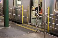 Movable gap filler at station
 -
 Conductor controls the whole length of the curved platform using monitors
 -
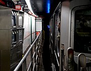
 Passageway to BMT platforms as seen from end of loop platform


.jpg)
- Old station's mosaics
-
 Mosaic tile name tablet
 -
 Artwork on the left
 -
 One of the many boat mosaics within the station


- New station
-
 Glass mural by Doug and Mike Starn
 -
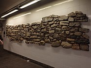 Excavated wall
 -
 Flooded station after Hurricane Sandy


.jpg)
BMT Broadway Line platforms
Whitehall Street–South Ferry | |||||||||||||||||||||||||||||||||||||||||||||||||||||||||||||||||||||||||||||||||||||||||||||||||||||||
|---|---|---|---|---|---|---|---|---|---|---|---|---|---|---|---|---|---|---|---|---|---|---|---|---|---|---|---|---|---|---|---|---|---|---|---|---|---|---|---|---|---|---|---|---|---|---|---|---|---|---|---|---|---|---|---|---|---|---|---|---|---|---|---|---|---|---|---|---|---|---|---|---|---|---|---|---|---|---|---|---|---|---|---|---|---|---|---|---|---|---|---|---|---|---|---|---|---|---|---|---|---|---|---|
 Middle track with W train departing | |||||||||||||||||||||||||||||||||||||||||||||||||||||||||||||||||||||||||||||||||||||||||||||||||||||||
| Station statistics | |||||||||||||||||||||||||||||||||||||||||||||||||||||||||||||||||||||||||||||||||||||||||||||||||||||||
| Division | B (BMT)[1] | ||||||||||||||||||||||||||||||||||||||||||||||||||||||||||||||||||||||||||||||||||||||||||||||||||||||
| Line | BMT Broadway Line | ||||||||||||||||||||||||||||||||||||||||||||||||||||||||||||||||||||||||||||||||||||||||||||||||||||||
| Services | N R W | ||||||||||||||||||||||||||||||||||||||||||||||||||||||||||||||||||||||||||||||||||||||||||||||||||||||
| Structure | Underground | ||||||||||||||||||||||||||||||||||||||||||||||||||||||||||||||||||||||||||||||||||||||||||||||||||||||
| Platforms | 2 island platforms cross-platform interchange | ||||||||||||||||||||||||||||||||||||||||||||||||||||||||||||||||||||||||||||||||||||||||||||||||||||||
| Tracks | 3 | ||||||||||||||||||||||||||||||||||||||||||||||||||||||||||||||||||||||||||||||||||||||||||||||||||||||
| Other information | |||||||||||||||||||||||||||||||||||||||||||||||||||||||||||||||||||||||||||||||||||||||||||||||||||||||
| Opened | September 20, 1918 | ||||||||||||||||||||||||||||||||||||||||||||||||||||||||||||||||||||||||||||||||||||||||||||||||||||||
| Accessible | |||||||||||||||||||||||||||||||||||||||||||||||||||||||||||||||||||||||||||||||||||||||||||||||||||||||
| Opposite- direction transfer | Yes | ||||||||||||||||||||||||||||||||||||||||||||||||||||||||||||||||||||||||||||||||||||||||||||||||||||||
| Former/other names | Whitehall Street | ||||||||||||||||||||||||||||||||||||||||||||||||||||||||||||||||||||||||||||||||||||||||||||||||||||||
| Traffic | |||||||||||||||||||||||||||||||||||||||||||||||||||||||||||||||||||||||||||||||||||||||||||||||||||||||
| 2023 | 5,995,305[2] | ||||||||||||||||||||||||||||||||||||||||||||||||||||||||||||||||||||||||||||||||||||||||||||||||||||||
| Rank | 36 out of 423[2] | ||||||||||||||||||||||||||||||||||||||||||||||||||||||||||||||||||||||||||||||||||||||||||||||||||||||
| |||||||||||||||||||||||||||||||||||||||||||||||||||||||||||||||||||||||||||||||||||||||||||||||||||||||
| |||||||||||||||||||||||||||||||||||||||||||||||||||||||||||||||||||||||||||||||||||||||||||||||||||||||
| |||||||||||||||||||||||||||||||||||||||||||||||||||||||||||||||||||||||||||||||||||||||||||||||||||||||
The Whitehall Street–South Ferry station[156] on the BMT Broadway Line has three tracks and two island platforms, and is the southernmost station on the line. The R stops here at all times; the W stops here only on weekdays during the day; and the N stops here at night. The outer tracks, used by daytime R and nighttime N trains, continue south into the Montague Street Tunnel to the BMT Fourth Avenue Line in Brooklyn. The center track, which is used to terminate weekday W trains from Queens[164] and nighttime R trains from Brooklyn,[165] merges with the outer tracks at both ends of the station.[124] The station is between Rector Street to the north and Court Street to the south.[156]
The station is deep because of two factors: the line goes under the
South of this station, a pair of
Notable places nearby
- Downtown Manhattan Heliport[151]
- Whitehall Terminal[151]
- Ferries to Statue of Liberty, Ellis Island, and Governors Island[151]
- Other places in the neighborhood[151]
Notes
- 34th Street–Hudson Yards station, which opened in 2015, is the first completely new subway station since 1989, since it is standalone and does not connect to any pre-existing stations.[85]
- ^ In 1985, the RR became the R.[139] The N and R routes' northern termini were swapped in 1987, so the N went to Ditmars Boulevard and the R went to 71st Avenue.[140]
- arcis 77.5 degrees.
References
- ^ a b c d "Glossary". Second Avenue Subway Supplemental Draft Environmental Impact Statement (SDEIS) (PDF). Vol. 1. Metropolitan Transportation Authority. March 4, 2003. pp. 1–2. Archived from the original (PDF) on February 26, 2021. Retrieved January 1, 2021.
- ^ a b c d e f g h "Annual Subway Ridership (2018–2023)". Metropolitan Transportation Authority. 2023. Retrieved April 20, 2024.
- ^ "Annual Subway Ridership (2018–2023)". Metropolitan Transportation Authority. 2023. Retrieved April 20, 2024.
- ^ a b c d e Walker, James Blaine (1918). Fifty Years of Rapid Transit — 1864 to 1917. New York, N.Y.: Law Printing. Retrieved November 6, 2016.
- ^ a b "Interborough Rapid Transit System, Underground Interior" (PDF). New York City Landmarks Preservation Commission. October 23, 1979. Archived (PDF) from the original on September 21, 2020. Retrieved November 19, 2019.
- ^ Report of the Board of Rapid Transit Railroad Commissioners for the City of New York For The Year Ending December 31, 1904 Accompanied By Reports of the Chief Engineer and of the Auditor. Board of Rapid Transit Railroad Commissioners. 1905. pp. 229–236.
- ^ Report of the Board of Rapid Transit Railroad Commissioners For And In The City of New York Up to December 31, 1901. Board of Rapid Transit Railroad Commissioners. 1902. Archived from the original on May 2, 2022. Retrieved December 26, 2020.
- ^ Scott, Charles (1978). "Design and Construction of the IRT: Civil Engineering" (PDF). Historic American Engineering Record. pp. 208–282 (PDF pp. 209–283). Archived (PDF) from the original on January 17, 2021. Retrieved December 20, 2020.
 This article incorporates text from this source, which is in the public domain.
{{cite web}}: CS1 maint: postscript (link) - ^ "Brooklyn Branch Begun: Subway Men Break Ground". New-York Tribune. November 11, 1902. p. 6. Archived from the original on May 10, 2022. Retrieved May 10, 2022 – via newspapers.com.
- ^ ProQuest 128366357.
- ^ ISSN 0362-4331. Retrieved June 16, 2023.
- ^ "Subway Trains Running From Bronx to Battery — West Farms and South Ferry Stations Open at Midnight — Start Without a Hitch — Bowling Green Station Also Opened — Lenox Avenue Locals Take City Hall Loop Hereafter". New York Times. July 10, 1905. p. 1. Archived from the original on November 6, 2016. Retrieved November 6, 2016.
- ProQuest 571684437.
- from the original on May 2, 2022. Retrieved November 11, 2016.
- ^ from the original on May 2, 2022. Retrieved March 3, 2010.
- ^ a b c Hood, Clifton (1978). "The Impact of the IRT on New York City" (PDF). Historic American Engineering Record. pp. 146–207 (PDF pp. 147–208). Archived (PDF) from the original on January 17, 2021. Retrieved December 20, 2020. This article incorporates text from this source, which is in the public domain.
{{cite web}}: CS1 maint: postscript (link) - ^ a b Report of the Public Service Commission for the First District of the State of New York For The Year Ending December 31, 1910. Public Service Commission. 1911. Archived from the original on January 20, 2021. Retrieved January 8, 2021.
- from the original on April 5, 2018. Retrieved April 5, 2018.
- ^ (PDF) from the original on July 7, 2021. Retrieved November 10, 2017.
- ^ a b c Engineering News-record. McGraw-Hill Publishing Company. 1916. Archived from the original on May 4, 2022. Retrieved October 15, 2020.
- ^ (PDF) from the original on December 12, 2019. Retrieved August 26, 2016.
- ^ (PDF) from the original on July 13, 2021. Retrieved November 6, 2016.
- ^ from the original on October 18, 2022. Retrieved October 18, 2022.
- from the original on October 18, 2022. Retrieved October 18, 2022.
- ^ "Red Hook Routes in Transfer Tangle". The Standard Union. July 13, 1914. p. 12. Archived from the original on October 18, 2022. Retrieved October 18, 2022.
- from the original on October 19, 2022. Retrieved October 19, 2022.
- from the original on October 22, 2022. Retrieved October 19, 2022.
- ^ ProQuest 575923274.
- ^ from the original on December 12, 2021. Retrieved October 18, 2022.
- from the original on January 7, 2022. Retrieved May 14, 2022.
- ProQuest 1248134780.
- from the original on August 28, 2022. Retrieved August 28, 2022.
- ^ "Annual Report For The Year Ended June 30, 1959" (PDF). nycsubway.org. New York City Transit Authority. October 1959. pp. 9–10. Archived (PDF) from the original on May 11, 2021. Retrieved December 21, 2020.
- from the original on October 19, 2022. Retrieved October 18, 2022.
- ^ "Broadway Subway Opened To Coney By Special Train. Brooklynites Try New Manhattan Link From Canal St. to Union Square. Go Via Fourth Ave. Tube". The Brooklyn Daily Eagle. September 4, 1917. Retrieved May 31, 2019.
- from the original on June 12, 2018. Retrieved December 27, 2020.
- (PDF) from the original on August 31, 2021. Retrieved November 5, 2016.
- ProQuest 575840136.
- ^ "B.R.T. Overcrowded Because of Incomplete Parts, Says Company". The Brooklyn Citizen. January 25, 1918. p. 3. Archived from the original on October 18, 2022. Retrieved October 18, 2022.
- ^ "B.R.T. to Improve Service on Brighton and West End Lines". The Brooklyn Daily Eagle. August 23, 1918. p. 1. Archived from the original on October 18, 2022. Retrieved October 18, 2022.
- ^ a b District, New York (State) Public Service Commission First (January 1, 1919). Report of the Public Service Commission for the First District of the State of New York. J.B. Lyon Company.
- ^ a b Legislative Documents. J.B. Lyon Company. 1920 – via Google Books.
- (PDF) from the original on January 12, 2023. Retrieved February 24, 2021.
- ProQuest 576155260.
- ^ a b "New B.R.T. Lines Open – Broadway-Brighton Trains, on Holiday Schedule, Have Light Traffic" (PDF). The New York Times. August 2, 1920. Archived (PDF) from the original on May 4, 2022. Retrieved November 5, 2016.
- from the original on April 28, 2023. Retrieved April 28, 2023.
- ISSN 0362-4331. Retrieved May 12, 2023.
- ProQuest 1113704092.
- from the original on July 19, 2021. Retrieved May 14, 2022.
- ProQuest 1243059209.
- ^ "About NYC Transit – History". mta.info. Metropolitan Transportation Authority. October 18, 2002. Archived from the original on October 19, 2002. Retrieved September 18, 2016.
{{cite web}}: CS1 maint: bot: original URL status unknown (link) - ISSN 0362-4331. Retrieved May 9, 2023.
- ^ a b c d e f g h i j k l m n o p q r s t "Environmental Assessment and Section 4(f) Evaluation, Section 1.0: Purpose and Need and Description for the Proposed Action" (PDF). mta.info. Metropolitan Transportation Authority. May 2004. Archived (PDF) from the original on January 7, 2017. Retrieved December 17, 2016.
- from the original on November 24, 2021. Retrieved October 17, 2022.
- ProQuest 279637870.
- ProQuest 305722778.
- ^ ProQuest 398958828.
- from the original on February 26, 2018. Retrieved October 17, 2022.
- ^ Hetter, Katia (February 8, 2003). "WTC Transit Work to Begin in '04". Newsday. p. 11. Archived from the original on October 17, 2022. Retrieved October 17, 2022.
- United States General Accounting Office. October 2003. Archived(PDF) from the original on February 10, 2017. Retrieved December 16, 2016.
- ^ from the original on February 17, 2015. Retrieved June 7, 2009.
- ^ Young, Dana (September 22, 2005). "Opposition to South Ferry subway project grows". Downtown Express. Archived from the original on March 4, 2016. Retrieved October 31, 2015.
- ^ Donohue, Pete; Haberman, Maggie (April 2, 2003). "2nd thoughts on S. Ferry". New York Daily News. p. 21. Archived from the original on October 17, 2022. Retrieved October 17, 2022.
- from the original on September 21, 2017. Retrieved September 20, 2017.
- ^ "South Ferry Terminal Update for Community Board 1" (PDF). mta.info. Metropolitan Transportation Authority. February 10, 2005. Archived (PDF) from the original on September 25, 2014. Retrieved December 17, 2016.
- ProQuest 305875902.
- ^ Robin, Joshua (April 30, 2004). "Rep: We get terminal, you get subway". Newsday. p. 2. Archived from the original on October 17, 2022. Retrieved October 17, 2022.
- from the original on November 21, 2018. Retrieved October 17, 2022.
- ^ Taylor, Curtis L. (June 19, 2004). "South Ferry Subway Expansion, $400m Deal Would Cut Commute Time". Newsday. p. 12. Archived from the original on October 17, 2022. Retrieved October 17, 2022.
- ^ a b c "Finding of No Significant Impact: South Ferry Terminal Project" (PDF). mta.info. Federal Transit Administration. August 30, 2004. Archived (PDF) from the original on December 20, 2016. Retrieved December 18, 2016.
- ^ ProQuest 306146409.
- from the original on May 14, 2019. Retrieved May 14, 2019.
- ProQuest 305997889.
- ^ a b c d e Haddon, Heather (February 24, 2010). "Unearthing colonial New York: South Ferry project yields 65K artifacts". Newsday. Archived from the original on February 19, 2018. Retrieved February 18, 2018.
- from the original on January 26, 2021. Retrieved October 10, 2022.
- from the original on April 10, 2015. Retrieved October 10, 2022.
- ^ Donohue, Pete (December 12, 2008). "New South Ferry station to open in January". New York Daily News. Archived from the original on December 20, 2016. Retrieved December 17, 2016.
- from the original on October 18, 2022. Retrieved October 18, 2022.
- ^ a b c Donohue, Pete (January 28, 2009). "Rail dumb, MTA! Platform at South Ferry station 1 inch too far from train". New York Daily News. Archived from the original on October 18, 2022. Retrieved October 18, 2022.
- ^ "Staten Island commuters counting down days until new subway station opens". SILive.com. March 11, 2009. Archived from the original on October 29, 2015. Retrieved October 31, 2015.
- ^ a b c d "South Ferry station opening to Staten Island commuters". SILive.com. March 16, 2009. Archived from the original on August 8, 2017. Retrieved December 17, 2016.
- ^ "MTA Opens New South Ferry Subway Terminal". mta.info. Metropolitan Transportation Authority. March 16, 2009. Archived from the original on December 23, 2015. Retrieved December 18, 2016.
- ^ Donohue, Pete (March 17, 2009). "MTA opens new $530M South Ferry station". New York Daily News. Archived from the original on August 17, 2016. Retrieved July 21, 2016.
- from the original on August 8, 2017. Retrieved December 17, 2016.
- ^ Fitzsimmons, Emma G. (September 12, 2015). "Subway Station to Open This Weekend, Bringing 7 Line to Far West Side". The New York Times. Archived from the original on September 14, 2015. Retrieved September 13, 2015.
- ^ "MTA Capital Construction – Procurement". web.mta.info. Archived from the original on August 27, 2017. Retrieved October 23, 2016.
- ^ "New Amsterdam Pavilion adds excitement to Peter Minuit Plaza". The Real Deal New York. May 26, 2011. Archived from the original on May 14, 2019. Retrieved May 14, 2019.
- ^ "Peter Minuit Plaza opens with Dutch feeling". The Villager. May 18, 2011. Archived from the original on May 14, 2019. Retrieved May 14, 2019.
- ^ a b c d Donohue, Pete (April 4, 2013). "South Ferry subway station reopens to public after Sandy damage". New York Daily News. Archived from the original on February 2, 2017. Retrieved December 17, 2016.
- ^ from the original on October 18, 2022. Retrieved October 18, 2022.
- ^ a b c Donohue, Peter (December 8, 2014). "$194 million contract awarded to upgrade South Ferry subway station". New York Daily News. Archived from the original on February 7, 2015. Retrieved February 7, 2015.
- ^ from the original on October 18, 2022. Retrieved October 18, 2022.
- from the original on January 21, 2013. Retrieved October 18, 2022.
- ^ Associated Press (January 18, 2013). "Repairs to South Ferry subway station, used by Staten Island commuters, could take 3 years". silive. Archived from the original on October 18, 2022. Retrieved October 18, 2022.
- ^ Paulsen, Ken (December 21, 2012). "Full R train service returns to Whitehall Street, used by Staten Island Ferry riders". silive. Archived from the original on October 18, 2022. Retrieved October 18, 2022.
- ^ a b Paulsen, Ken (January 29, 2013). "MTA urged to consider re-opening 'old' South Ferry subway station". silive. Archived from the original on October 18, 2022. Retrieved October 18, 2022.
- ^ a b Flegenheimer, Matt (March 8, 2013). "Storm Damage Prompts Return of Old Subway Stop". The New York Times. Archived from the original on October 27, 2015. Retrieved July 23, 2016.
- from the original on April 10, 2013. Retrieved October 18, 2022.
- ^ from the original on November 11, 2022. Retrieved November 11, 2022.
- ^ a b Flegenheimer, Matt (April 3, 2013). "Subway Service Is Returning to Old South Ferry Station". City Room. Archived from the original on February 4, 2018. Retrieved February 24, 2018.
- ^ "mta.info | Superstorm Sandy: One Year Later". web.mta.info. Archived from the original on August 16, 2016. Retrieved July 24, 2016.
- ^ a b "mta.info | Superstorm Sandy: One Year Later". web.mta.info. Metropolitan Transportation Authority. Archived from the original on August 3, 2016. Retrieved July 23, 2016.
- ^ a b c "Capital Program Oversight Committee Meeting" (PDF). mta.info. Metropolitan Transportation Authority. July 2017. Archived (PDF) from the original on September 1, 2017. Retrieved September 15, 2017.
- from the original on October 18, 2022. Retrieved October 18, 2022.
- ^ Walker, Ameena (October 28, 2017). "MTA reveals new storm protection gear for vulnerable subway stations". Curbed NY. Archived from the original on October 18, 2022. Retrieved October 18, 2022.
- ^ Rivoli, Dan (October 29, 2016). "South Ferry station entrance to close for more than 9 months". New York Daily News. Archived from the original on October 30, 2015. Retrieved October 31, 2015.
- ^ "South Ferry Station on Track to Reopen this Summer after Hurricane Sandy Repairs". TWC News. Archived from the original on January 21, 2017. Retrieved January 22, 2017.
- ^ Chung, Jen (June 28, 2017). "Photos: Hurricane Sandy-Ravaged South Ferry Subway Station Is Finally Back". Gothamist. Archived from the original on October 18, 2022. Retrieved October 18, 2022.
- ^ a b c "South Ferry subway station in Manhattan reopens". ABC 7 New York. June 27, 2017. Archived from the original on June 27, 2017. Retrieved June 27, 2017.
- ^ a b c Warerkar, Tanay (June 26, 2017). "South Ferry subway station readies for its reopening after Sandy". Curbed NY. Archived from the original on August 4, 2017. Retrieved June 27, 2017.
- ^ a b c d Kirby, Jen (June 27, 2017). "The New South Ferry Station Finally Reopens After Hurricane Sandy". Intelligencer. Archived from the original on October 18, 2022. Retrieved October 18, 2022.
- ^ The Merchants' Association of New York Pocket Guide to New York. Merchants' Association of New York. March 1906. pp. 19–26.
- ^ a b Report of the Public Service Commission for the First District of the State of New York. J.B. Lyon Company, printers. 1908. p. 194. Archived from the original on May 2, 2022. Retrieved February 22, 2020.
- ProQuest 575909557.
- from the original on November 22, 2022. Retrieved November 22, 2022.
- ^ "Open New Subway Lines to Traffic; Called a Triumph — Great H System Put in Operation Marks an Era in Railroad Construction — No Hitch in the Plans — But Public Gropes Blindly to Find the Way in Maze of New Stations — Thousands Go Astray — Leaders in City's Life Hail Accomplishment of Great Task at Meeting at the Astor" (PDF). The New York Times. August 2, 1918. p. 1. Archived (PDF) from the original on February 21, 2021. Retrieved November 6, 2016.
- ^ a b "Open Clark Street Line — New Route Doubles Subway Service Between the Two Boroughs" (PDF). The New York Times. April 16, 1919. p. 18. Archived (PDF) from the original on December 17, 2021. Retrieved November 6, 2016.
- ^ Brown, Nicole (May 17, 2019). "How did the MTA subway lines get their letter or number? NYCurious". amNewYork. Archived from the original on March 2, 2021. Retrieved January 27, 2021.
- ^ Friedlander, Alex; Lonto, Arthur; Raudenbush, Henry (April 1960). "A Summary of Services on the IRT Division, NYCTA" (PDF). New York Division Bulletin. 3 (1). Electric Railroaders' Association: 2–3. Archived (PDF) from the original on September 14, 2020. Retrieved January 27, 2021.
- from the original on January 1, 2018. Retrieved November 6, 2016.
- ^ a b c d e f g h i j k Kevin Walsh (December 2008). "Last Days at South Ferry". Forgotten NY. Archived from the original on July 8, 2015. Retrieved July 7, 2015.
- ^ a b c "M.T.A. Expected to Save Franklin Avenue Shuttle, Once an Austerity Target". The New York Times. February 10, 1977. p. 27. Archived from the original on July 23, 2018. Retrieved July 18, 2010.
- ^ Cunningham, Joseph; DeHart, Leonard O. (January 1, 1993). A History of the New York City Subway System. J. Schmidt, R. Giglio, and K. Lang.
- ^ OCLC 1056711733.
- from the original on August 10, 2016. Retrieved June 15, 2016.
- ^ Moore, Keith (June 10, 1988). "TA's skip-stop plan hit". New York Daily News. Archived from the original on November 8, 2018. Retrieved November 8, 2018.
- ^ "#1 Riders: Your Service is Changing". New York Daily News. August 20, 1989. Archived from the original on November 8, 2018. Retrieved November 8, 2018.
- ^ "Announcing 1 and 9 Skip-Stop Service on the Broadway-Seventh Avenue Line" (PDF). New York City Transit Authority. August 1989. Archived from the original (PDF) on June 26, 2020. Retrieved August 1, 2009.
- from the original on August 10, 2016. Retrieved June 15, 2016.
- from the original on March 17, 2015. Retrieved August 29, 2016.
- ^ "Noteworthy – 9 discontinued". mta.info. Metropolitan Transportation Authority. May 7, 2005. Archived from the original on May 7, 2005. Retrieved September 18, 2016.
- ^ "Clark St Tunnel Reconstruction Weekend Service Changes". web.mta.info. Metropolitan Transportation Authority. June 8, 2017. Archived from the original on August 25, 2017. Retrieved June 8, 2017.
- ^ from the original on May 30, 2020. Retrieved October 18, 2022.
- from the original on October 18, 2022. Retrieved October 18, 2022.
- ^ "New B.R.T. Tunnel Schedule is Given". New York Herald. July 30, 1920. p. 16. Archived from the original on October 18, 2022. Retrieved October 18, 2022.
- ^ from the original on June 14, 2018. Retrieved October 18, 2022.
- ^ Perlmutter, Emanuel (November 16, 1967). "Subway Changes to Speed Service: Major Alterations in Maps, Routes and Signs Will Take Effect Nov. 26" (PDF). The New York Times. p. 1. Archived from the original on October 30, 2021. Retrieved July 7, 2015.
- ^ "Service Adjustment on BMT and IND Lines Effective 1 A.M. Monday, Aug. 30". Flickr. New York City Transit Authority. August 1976. Archived from the original on January 5, 2017. Retrieved October 23, 2016.
- ^ "Hey, What's a "K" train? 1985 Brochure". New York City Transit Authority. 1985. Archived from the original on September 15, 2016. Retrieved June 17, 2016 – via Flickr.
- ^ Annual Report on ... Rapid Routes Schedules and Service Planning. New York City Transit Authority. 1989. p. 16.
- from the original on October 18, 2022. Retrieved October 18, 2022.
- from the original on March 8, 2021. Retrieved October 18, 2022.
- ^ from the original on October 18, 2022. Retrieved October 18, 2022.
- ^ a b Son, Hugh (February 15, 2004). "ABC's of subway swap Manhattan Bridge fix changes 7 lines". New York Daily News. Archived from the original on February 26, 2018. Retrieved February 25, 2018.
- ^ a b Rivoli, Dan (November 7, 2016). "W train returns Monday after removed from subway tracks in 2010". New York Daily News. Archived from the original on October 18, 2022. Retrieved October 18, 2022.
- ^ a b "After 6 years, W trains running between Manhattan, Queens". ABC7 New York. November 7, 2016. Archived from the original on October 18, 2022. Retrieved October 18, 2022.
- from the original on October 18, 2022. Retrieved October 18, 2022.
- ^ Lam, Katherine (October 23, 2016). "MTA flyers spotted for W train's return in November". PIX11. Archived from the original on September 30, 2020. Retrieved October 24, 2016.
- ^ a b "7: Transportation". Governors Island—North Island Re-Tenanting and Park and Public Space Master Plan Draft Environmental Impact Statement (PDF). New York City Department of City Planning. 2011. p. 85. Archived (PDF) from the original on October 19, 2022. Retrieved April 1, 2021.
- ^ a b Louis Berger Group Inc. (2003). Proposed New South Ferry Terminal, Lower Manhattan, New York, New York, Phase IA Archaeological Assessment (PDF) (Report). New York City Landmarks Preservation Commission. Archived (PDF) from the original on October 19, 2022. Retrieved October 19, 2022.
- ^ a b c d e f g h i j k l "MTA Neighborhood Maps: Lower Manhattan" (PDF). mta.info. Metropolitan Transportation Authority. 2016. Archived (PDF) from the original on October 5, 2016. Retrieved June 27, 2016.
- ^ a b "MTA Opens New South Ferry Subway Terminal" (Press release). Metropolitan Transportation Authority. March 16, 2009. Archived from the original on December 23, 2015. Retrieved June 7, 2009.
- ^ a b Lower Manhattan Development Corporation (2007). East River Waterfront Esplanade and Piers: Environmental Impact Statement. p. 6.19. Retrieved February 19, 2018.
- ^ "1972 System Map". www.nycsubway.org. Retrieved April 17, 2024.
- ^ "1 Subway Timetable, Effective August 12, 2023". Metropolitan Transportation Authority. Retrieved August 26, 2023.
- ^ a b c "Subway Map" (PDF). Metropolitan Transportation Authority. September 2021. Retrieved September 17, 2021.
- ^ a b c d Yates, Maura (December 12, 2008). "New subway station has plenty of upside". Staten Island Advance. Archived from the original on August 10, 2009. Retrieved June 7, 2009.
- from the original on May 12, 2016. Retrieved December 17, 2016.
- ^ Cuza, Bobby (December 11, 2008). "Brand-New South Ferry Station To Open Soon". NY1. Archived from the original on August 10, 2009. Retrieved June 7, 2009.
- ^ Stv Inc. (February 2020). "New York City Transit System-wide Platform Screen Door Feasibility Study Summary of Conclusions". Metropolitan Transportation Authority. Archived from the original on January 27, 2022. Retrieved January 28, 2022.
- ^ "MTA – Arts & Design | NYCT Permanent Art". web.mta.info. Archived from the original on August 16, 2016. Retrieved July 23, 2016.
- ^ "New subway station has plenty of upside". www.silive.com. Archived from the original on August 10, 2009. Retrieved July 23, 2016.
- ^ from the original on December 20, 2016. Retrieved December 17, 2016.
- ^ "W Subway Timetable, Effective June 26, 2022". Metropolitan Transportation Authority. Retrieved August 26, 2023.
- ^ "R Subway Timetable, Effective August 28, 2023". Metropolitan Transportation Authority. Retrieved August 26, 2023.
- ^ "Figure 5: South Ferry Terminal Project Conceptual Site Plan" (PDF). mta.info. Metropolitan Transportation Authority. Archived (PDF) from the original on December 27, 2016. Retrieved December 17, 2016.
Further reading
- Stookey, Lee (1994). Subway ceramics : a history and iconography of mosaic and bas relief signs and plaques in the New York City subway system. Brattleboro, Vt: L. Stookey. OCLC 31901471.
External links
- South Ferry Terminal Project — Official MTA South Ferry Station Project Page