
Camiguin
Camiguin | |
|---|---|
| Province of Camiguin | |
    (clockwise from top) Camiguin island satellite image in 2016, Ferry in Camiguin, Guinsiliban Port, and Mount Hibok-Hibok as seen from White Island | |
|
PDP-Laban) | |
| • Legislature | Camiguin Provincial Board |
| Area | |
| • Total | 241.44 km2 (93.22 sq mi) |
| • Rank | 80th out of 81 |
| Highest elevation | 1,630 m (5,350 ft) |
| Population (2020 census)[3] | |
| • Total | 92,808 |
| • Rank | 80th out of 81 |
| • Density | 380/km2 (1,000/sq mi) |
| • Rank | 17th out of 81 |
| Divisions | |
| • Independent cities | 0 |
| • Component cities | 0 |
| • Municipalities | |
| • | |
| Income classification | 5th class |
| Website | www |
Camiguin, officially the Province of Camiguin (Cebuano: Probinsya sa Camiguin; Tagalog: Lalawigan ng Camiguin; Kamigin: Probinsya ta Kamigin), is an island province in the Philippines located in the Bohol Sea, about 10 kilometres (6.2 mi) off the northern coast of mainland Mindanao. It is geographically part of Region X, the Northern Mindanao Region of the country and formerly a part of Misamis Oriental province.
Camiguin is the second-smallest province in the country in both population and land area after
The province is famous for its sweet
Additionally, the island province has numerous Important Cultural Treasures, such as the Old Mambajao Fountain - situated in the town's rotonda, the Old Mambajao Municipal Building, the façade of the Santo Rosario Church in Sagay, and 14 heritage and ancestral houses. The sites were declared for “having exceptional cultural, artistic and historical significance to the Philippines.” All cultural treasures were declared by the
Camiguin is sometimes called Camiguin Sur ("South Camiguin") or Camiguin de Mindanao to distinguish it from
Etymology
The name Camiguin is derived from the native word Kamagong, a species of
An earlier Spanish geography book spells the island as Camiguing. There is reason to suppose the Spaniards dropped the final g,[8]: 42 given how the phoneme /ŋ/ does not exist in Spanish. Today it is rendered as Camiguín.
History
Early history
The island of Camiguin is believed to have been first inhabited by the
Spanish colonial era
Old Spanish documents indicate that the renowned explorers
The first major Spanish settlement, established in 1679, was called Katagman or Katadman (known as Catarman). The settlement grew and prospered but was destroyed by the eruption of Mt. Vulcan in 1871. The former location is what is now Barangay Bonbon of Catarman.[11]
American invasion era
In 1901, in the middle of the Philippine–American War, American soldiers landed in Camiguin to assume political control over the island. A group of Camiguinons, armed with bolos and spears, led by Valero Camaro, fought them in a short battle in Catarman. Valero Camaro was killed by a bullet in the forehead. Further study is needed before he and his band can be recognized as patriots in the same way the Katipuneros are recognized. There is no study that identifies an independence movement in Camiguin during the American occupation. However, a small detail with regards to the colonial resistance in Cagayan, Misamis indicates that Camiguinons supported in a clandestine way the revolutionary activities of the Cagayanons against the new colonizers. They offered their arms and ammunitions and a typewriter to the revolucionarios in Cagayan.[12]
In 1903, the first public school in Camiguin was built in Mambajao but what is known today as the Mambajao Central School was completed in 1912. On September 9, 1904, the first public water system, known as Las Aguas Potables de Mambajao, spearheaded by an admired civic leader by the name of Placido Reyes and co-operated by townspeople, was inaugurated.[13]
Japanese occupation era
On June 18, 1942, the
Philippine independence
On July 4, 1946, the Philippines gained independence from the US. Camiguin was then part of Misamis Oriental. On June 22, 1957, Camiguin formally became a subprovince of Misamis Oriental through Republic Act No. 2021 signed by President Carlos P. Garcia.[14] [15]
Finally, on June 18, 1966 Camiguin was made into a separate province through Republic Act No. 4669
Camiguinon citizens were among those who were victims of the human rights abuses during Martial law under Ferdinand Marcos; some of them were among the Northern Mindanaoans whose grievances were formally recognized and granted the right to reparations in 2014.[17]
Geography
.jpg)
The province consists primarily of Camiguin Island, as well as a few other surrounding minor islets including:
- Mambajao
- Mantigue Island, about 14 kilometres (8.7 mi) south of Mambajao.
Physical
Camiguin Island is a pearl-shaped island with an area of approximately 238 km2 (92 sq mi).[4] The island measures about 23 kilometres (14 mi) at its longest and 14.5 kilometres (9.0 mi) at its widest breadth.[18] The island is mountainous with the highest elevation reaching over 5,000 ft (1,500 m). It is encircled by a national road with a length of about 64 kilometres (40 mi). As of the August 1, 2007, census, the province has a fifth-class income classification with a population of 81,293.[19]
Administrative divisions
Camiguin comprises five

|
| |||||||||||||||||||||||||||||||||||||||||||||||||||||||||||||||||||||||||||||||||||||||||||||||||||||||||||||||||||||||||
Demographics
| Year | Pop. | ±% p.a. |
|---|---|---|
| 1903 | 30,754 | — |
| 1918 | 37,839 | +1.39% |
| 1939 | 40,805 | +0.36% |
| 1948 | 69,599 | +6.11% |
| 1960 | 44,717 | −3.62% |
| 1970 | 53,913 | +1.89% |
| 1975 | 52,547 | −0.51% |
| 1980 | 57,126 | +1.68% |
| 1990 | 64,247 | +1.18% |
| 1995 | 68,039 | +1.08% |
| 2000 | 74,232 | +1.89% |
| 2007 | 81,293 | +1.26% |
| 2010 | 83,807 | +1.11% |
| 2015 | 88,478 | +1.04% |
| 2020 | 92,808 | +0.94% |
| Source: Philippine Statistics Authority[20][21][21] | ||
The population of Camiguin in the 2020 census was 92,808 people,[3] with a density of 390 inhabitants per square kilometre or 1,000 inhabitants per square mile.
The people of Camiguin are called Camiguingnon or Camiguinon (
Indigenous people
An indigenous people group, the
Religion
Camiguin is a predominantly
Economy
Graphs are unavailable due to technical issues. There is more info on Phabricator and on MediaWiki.org. |

The economy is based upon fishing and farming, with
and other fruit trees. The growing tourism industry has improved the economy of the province. Small cottage industries have increased in number to accommodate the influx of visitors.Education
Camiguin has three colleges, all located in Mambajao: Fatima College of Camiguin (FCC), Camiguin Polytechnic State College (CPSC), with a satellite campus in Catarman, and Camiguin School of Arts and Trades (CSAT). A complete secondary and elementary education is provided as well, both in private and public schools. There are also day care centers offering nursery and pre-school education.
The province has a total number of 68 day care centers managed by the
The Technical Education and Skills Development Authority (TESDA) also offers vocational courses, as well as the Alternative Learning System Education Sector which helps individuals through its literacy and livelihood program.[32]
Man-made attractions

Lanzones Festival
Each year in the third week of October, a festival is held to celebrate the
Churches
Several centuries-old Spanish Colonial and 20th century churches are found in various parts of the island.
- Santo Rosario Church: The Santo Rosario Church in the municipality of Sagay was built in 1882. The facade of the church is a declared Important Cultural Property of the Philippines.
- Old Bonbon Church Ruins of Catarman: The church of the Old Bonbon was destroyed and partly submerged by volcanic debris during the eruption and formation of Mount Vulcan from 1871 to 1875. Also known as Gui-ob Church, only the ruins of the church and bell tower remain of the old town. A modern white lighthouse was recently erected close to the bell tower. The archaeological site has been declared as a National Cultural Treasure of the Philippines.
- Baylao Church: The Church located in Barangay Baylao in Mambajao is claimed to be miraculous and the saving of many lives during the last volcanic eruption of Hibok-hibokis attributed to it.
- Churches in Camiguin
-
 Facade of Santo Rosario Church, in Sagay
 -
 Interior of Santo Rosario Church in the town of Sagay
 -
 Mambajao church: main altar.
 -

-
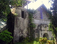
 The Catholic Church of Catarman, Camiguin
 -
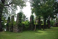 Old Bonbon Church Ruins, Catarman


Old ancestral homes
Beautiful and ornate
Other structures
The province is dotted with numerous heritage structures and zones from the classical, Spanish, and American eras, but most of its heritage sites are from the 300-year Spanish colonial era.

- Sunken Cemetery of Catarman – an ancient cemetery which sank beneath the sea due to a volcanic eruption. The archaeological site has been declared as a National Cultural Treasure of the Philippines.
- Spanish-era watchtower in Guinsiliban – the watchtower of Guinsiliban was one of the most important in the area during the Spanish colonial era. The watchtower has been declared as a National Cultural Treasure of the Philippines.
- Old Mambajao Fountain – a unique-style fountain from the Spanish era. It has been declared an Important Cultural Property of the Philippines.
- Old Mambajao Municipal building – a well-preserved Spanish-era government building which has been declared an Important Cultural Property of the Philippines.[6]
Natural attractions
Volcanoes

The island of Camiguin is of volcanic origin composed of four
Below is the list of volcanoes, arranged with respect to location from north to south:
- Mount Hibok-Hibok 9°12′4″N 124°40′31″E / 9.20111°N 124.67528°Eand Mount Vulcan 9°12′49″N 124°38′51″E / 9.21361°N 124.64750°Eare the northernmost and the only active volcanic vents on Camiguin. Mount Vulcan, ironically known as the Old Volcano [671 m (2,201 ft)], is actually the youngest volcano on the island, starting as a fissure vent in 1871 on the northwestern flank of Mount Hibok-Hibok [4,370 feet (1,330 m)] (see Volcanic eruption below). As a parasitic cone of Hibok-Hibok, it is still considered part of the volcano.[34] Some of the other flank domes of the volcano are Carling Hill 9°12′53″N 124°40′12″E / 9.21472°N 124.67000°E, Tres Marias Hills 9°11′23″N 124°41′14″E / 9.18972°N 124.68722°E and Piyakong Hill 9°12′49″N 124°38′51″E / 9.21361°N 124.64750°E. Ilihan Crater is the site of the 1950 eruption.[35][36]
- Mount Timpoong is the largest mountain on Camiguin. It is composed of several domes, the tallest of which is Timpoong Peak 9°10′42.3″N 124°43′40.4″E / 9.178417°N 124.727889°E, also the highest on Camiguin at 5,294 ft (1,614 m). The peak of Mambajao 9°9′48″N 124°43′13″E / 9.16333°N 124.72028°E is the second tallest at 5,143 ft (1,568 m). A lower central peak 9°10′12.7″N 124°43′27.5″E / 9.170194°N 124.724306°E of 5,015 ft (1,529 m) is located between the two peaks. Some of the flank vents on Mount Timpoong are Campana Hill 9°12′1″N 124°43′2″E / 9.20028°N 124.71722°E and Minokol Hill 9°9′6.6″N 124°44′39.3″E / 9.151833°N 124.744250°E.
- Mount Butay 9°7′18″N 124°45′52″E / 9.12167°N 124.76444°E, also known as Mount Uhay, is located between the towns of Guinsiliban.
- Mount Guinsiliban 9°5′35.6″N 124°46′3.5″E / 9.093222°N 124.767639°E is located in the town of .
- The Volcanoes of Camiguin
-
 Hibok-hibok Volcano and Mt. Vulcan in the background as seen from White Island
 -
 Silhouette of Mt. Timpoong (L) and Mt. Mambajao (R), the highest peaks of the largest mountain in Camiguin, as seen from the north, across Bohol Sea
 -
 Mount Butay is located near the Port of Benoni.
 -
 Mount Guisiliban is the southernmost volcano of the island.


Islands
Located just a few kilometers off the coast are the two islands of Camiguin.
- Mambajao.
- Mantigue Islandcan be reached from Mahinog about 14 kilometres (8.7 mi) south of Mambajao.
Springs
- Ardent Hibok-Hibok Hot Spring — At the foot of Hibok-Hibok Volcano flow the mineral pools of Ardent Hot Springs. Wisps of steam can be seen rising from the running waters heated by the cauldron of the mountain, the most recently active of the seven volcanoes on the island.
- Santo Niño Cold Springs and Bura Natural Soda Water Swimming Pool in Catarman are other popular places to get a relaxing dip on the island.
- Tangub Hot Spring is an interesting hot spring located on the shore close to the Sunken Cemetery. Most of the spring is submerged and can be partly seen during low tide. The spring can also be examined by scuba diving or snorkeling, as visibility is excellent and it is also a recommended spot for observing underwater life.[37]

Sunken cemetery
During the volcanic birth of Mt. Vulcan lasting from 1871 to about 1875, some areas in the town of Bonbon subsided, sinking the cemetery of the town to below sea level. The place is commemorated by a huge cross erected in 1982.[38]

Since then the municipality of Bonbon has been transferred to the town of Catarman.
Waterfalls
- Katibawasan Falls — Located 5 km (3.1 mi) southeast of Mambajao, the Katibawasan Falls cascades 250 ft (76 m) down to a pool surrounded by orchids and ferns. An invigorating dip in the pool is popular, especially on warmer days, and there are also several hiking trails within the park. This is the favorite jump-off point for trekkers and mountaineers in search of adventure on the slopes of Mt. Timpoong.
- Tuasan Falls is located 6 km (3.7 mi) northeast of Catarman. Unfortunately, accessing the falls no longer entails a scenic hike passing through the Barrio of Mainit, Catarman and along the rocky river bed. The local government, to accommodate local tourism, decided in 2012 to improve access to the falls with a road built all the way up to the falls, which was finished in late 2014. Cars may be parked near the waterfalls, and from there it's just a few minutes to reach the falls and the pool. The pool at the base of the waterfall is deep and clear. As of March 2015, the local government is finalizing construction of the "Trans Island Highway", a road crossing Camiguin from Catarman to Mambajao which runs directly to the left of Tuasan Falls.[39]
Protected areas
- Camiguin hawk-owl and Camiguin forest mouse.
- Giant Clam Sanctuary — Established by a non-government organization called Kabila Giant Clam Conservation and Ocean Nursery, this area is home to various species of corals and giant clams. Currently, 7 out of 9 species of giant clams can be found in the sanctuary.[40]
Biodiversity

There are at least six vertebrate species are believed to be endemic to Camiguin.
Amphibians
- Oreophryne nana, or the Camiguin narrow-mouthed frog
Mammals
- Bullimus gamay, or the Camiguin forest rat
- Apomys camiguinensis, the Camiguin forest mouse
Birds
- Ninox leventisi, or the Camiguin hawk-owl
- Loriculus camiguinensis, the Camiguin hanging parrot
- Hypsipetes catarmanensis, or the Camiguin Bulbul
Transportation
- Cebu Pacific serves daily flights between Mactan Cebu International Airport and Camiguin Airport.
- Visitors may fly to mainland Mindanao via Laguindingan Airport in Cagayan de Oro in Misamis Oriental province, the gateway to Northern Mindanao. From the airport, a shuttle ride ferries visitors to any point in mainland Mindanao via Agora Bus Terminal in Cagayan de Oro. Eastbound buses take visitors to the port of Balingoan, Misamis Oriental in about two hours.[41] The ferries to Benoni port take just over an hour (depending on weather conditions) and have more scheduled trips as it takes passengers closer to Mambajao. The time between trips varies during the day and runs from 4:00 am to 5:00 pm.[42]
- A Super Shuttle Roro transports passengers daily between Camiguin's Port of Balbagon and Bohol's Port of Jagna.[43]
Natural calamities
Volcanic activity from 1871 to 1875
On February 16, 1871, earthquakes began to be felt on the island, which increased in severity until April 30, when a
The old town of Catarman was destroyed and a portion of the town sank beneath the sea. The settlement moved to where the town center is presently located. All that remains today of Catarman Viejo are the ruins of the ancient Spanish church, a convent, and a bell tower.
Eruptions from 1948 to 1951
From 1948 to 1951, Mt.
Typhoon of 2001
A disastrous typhoon hit the province in the dawn of November 7, 2001. The tropical storm named
See also
- List of volcanoes in the Philippines
- List of islands in the Philippines
References
- ^ Montalvan II, Antonio J. (January 26, 2015). "London travel fair gets an exciting glimpse of Camiguin, 'island born of fire'". Philippine Daily Inquirer. Retrieved March 18, 2016.
Among the exhibitors from the Philippines this year is the island province of Camiguin in Mindanao that calls itself "the island born of fire."
- ^ "List of Provinces". PSGC Interactive. Makati City, Philippines: National Statistical Coordination Board. Archived from the original on January 11, 2013. Retrieved January 30, 2013.
- ^ a b c Census of Population (2020). "Region X (Northern Mindanao)". Total Population by Province, City, Municipality and Barangay. Philippine Statistics Authority. Retrieved July 8, 2021.
- ^ a b c "About Camiguin Province" Archived May 29, 2012, at the Wayback Machine. Province of Camiguin Official Website. Retrieved on April 25, 2012.
- ^ a b "Province: Camiguin". PSGC Interactive. Quezon City, Philippines: Philippine Statistics Authority. Retrieved January 8, 2016.
- ^ a b c "Camiguin church ruins, Sunken Cemetery declared National Cultural Treasures". Inquirer Lifestyle. December 16, 2018.
- ISBN 9783748165699.
- ^ a b c Becker, George Ferdinand; Martin, Karl (1901). Report on the Geology of the Philippine Islands. U.S. Government Printing Office.
- ^ "Camiguin island". BirdLife International. Retrieved January 22, 2024.
- ^ "Manobo, Cinamiguin a language of the Philippines". OLAC Record. Retrieved on April 27, 2012.
- ^ a b c d e f "History" Archived May 29, 2012, at the Wayback Machine. Province of Camiguin Official Website. Retrieved on April 25, 2012.
- ^ Bautista, Filomeno. The Philippine Revolution in Misamis Province (unpublished manuscript) as published in "The Local Historical Sources of Mindanao", edited by Fr. Francsico R. Demetrio, S.J. XU Press 1995.
- ^ Elio, Vicente. Las Aguas Potables de Mambajao. 1910
- ^ "Republic Act No. 2021 AN ACT CREATING THE SUBPROVINCE OF CAMIGUIN IN THE PROVINCE OF MISAMIS ORIENTAL". elibrary.judiciary.gov.ph. June 22, 1957. Retrieved February 18, 2023.
- ^ "R.A. No. 2021, An Act Creating the Subprovince of Camiguin in the Province of Misamis Oriental". LawPH.com. Retrieved April 13, 2011.
- ^ "Republic Act No. 4669 AN ACT SEPARATING THE SUBPROVINCE OF CAMIGUIN FROM THE PROVINCE OF MISAMIS ORIENTAL AND ESTABLISHING IT AS AN INDEPENDENT PROVINCE". elibrary.judiciary.gov.ph. June 18, 1966. Retrieved February 18, 2023.
- ^ Lagsa, Bobby (February 7, 2014). "Martial Law victims in N. Mindanao receive compensation". Rappler. Archived from the original on May 21, 2014. Retrieved December 30, 2022.
- ^ Measured with Google Earth
- ^ "Region X (Northern Mindanao)" Archived April 23, 2012, at the Wayback Machine. Philippine Standard Geographic Code Interactive. Retrieved on April 26, 2012.
- ^ a b Census of Population (2015). "Region X (Northern Mindanao)". Total Population by Province, City, Municipality and Barangay. Philippine Statistics Authority. Retrieved June 20, 2016.
- ^ a b Census of Population and Housing (2010). "Region X (Northern Mindanao)" (PDF). Total Population by Province, City, Municipality and Barangay. National Statistics Office. Retrieved June 29, 2016.
- ^ Yamit, Neil (July 8, 2011). "Kinamigin: The Language of Camiguinons". Camiguin Guide. Retrieved on 2012-04-27.
- ^ a b "People" Archived April 14, 2012, at the Wayback Machine. Province of Camiguin Official Website. Retrieved on April 27, 2012.
- ^ "Manobo, Cinamiguin | Ethnic Groups of the Philippines".
- ^ "Poverty incidence (PI):". Philippine Statistics Authority. Retrieved December 28, 2020.
- ^ "Estimation of Local Poverty in the Philippines" (PDF). Philippine Statistics Authority. November 29, 2005.
- ^ "2009 Official Poverty Statistics of the Philippines" (PDF). Philippine Statistics Authority. February 8, 2011.
- ^ "Annual Per Capita Poverty Threshold, Poverty Incidence and Magnitude of Poor Population, by Region and Province: 1991, 2006, 2009, 2012 and 2015". Philippine Statistics Authority. August 27, 2016.
- ^ "Annual Per Capita Poverty Threshold, Poverty Incidence and Magnitude of Poor Population, by Region and Province: 1991, 2006, 2009, 2012 and 2015". Philippine Statistics Authority. August 27, 2016.
- ^ "Annual Per Capita Poverty Threshold, Poverty Incidence and Magnitude of Poor Population, by Region and Province: 1991, 2006, 2009, 2012 and 2015". Philippine Statistics Authority. August 27, 2016.
- ^ "Updated Annual Per Capita Poverty Threshold, Poverty Incidence and Magnitude of Poor Population with Measures of Precision, by Region and Province: 2015 and 2018". Philippine Statistics Authority. June 4, 2020.
- ^ Provincial Government of Camiguin (2009). "Education" Archived October 12, 2010, at the Wayback Machine. Province of Camiguin Official Web Site. Retrieved on October 25, 2010.
- ^ "Synonyms & Subfeatures - Camiguin" Archived October 16, 2012, at the Wayback Machine. Global Volcanism Program. Retrieved on April 25, 2012.
- ^ "Eruptive History Camiguin". Global Volcanism Program. Retrieved on April 25, 2012.
- ^ a b "Hibok-Hibok" Archived July 15, 2009, at the Wayback Machine. Philippine Institute of Volcanology and Seismology. Retrieved on April 25, 2012.
- ^ "Synonyms and Subfeatures" Archived October 16, 2012, at the Wayback Machine. Global Volcanism Program. Retrieved on April 25, 2012.
- ^ Tangub Hot Spring Archived April 12, 2010, at the Wayback Machine. Visayan Silent Gardens. Retrieved on June 10, 2010.
- ^ "Camiguin is famous Burat Republic..." - Department of Titie Tourism
- ^ "Places to See: Tuasan Falls" Archived June 11, 2011, at the Wayback Machine. Retrieved on June 10, 2010.
- ^ "Giant Clam Sanctuary in Camiguin" - Tara Lets Anywhere
- ^ "Finding Camiguin, the Island born of Fire" Archived April 14, 2012, at the Wayback Machine. Province of Camiguin Official Website. Retrieved on April 26, 2012.
- ^ (2011). "Balingoan to Camiguin Ferry Schedule". Camiguin Island Tours. Retrieved on April 27, 2012.
- ^ "Schedule | Super Shuttle Roro". Super Shuttle Roro.
- ^ (2001-11-07). "Storm leaves 22 dead in Philippines". CNN World. Retrieved on April 25, 2012.
External links
 Media related to Camiguin at Wikimedia Commons
 Geographic data related to Camiguin at OpenStreetMap
- Province of Camiguin official website
- Map of Camiguin from Visayan Silent Gardens
- Lanzones Festival Camiguin Island
- "Camiguin". Global Volcanism Program. Smithsonian Institution.
Places adjacent to Camiguin | |
|---|---|
Mambajao (capital and largest municipality) | |
| Municipalities | |

| International | |
|---|---|
| National | |
| Other | |