
Rocksprings, Texas
Rocksprings, Texas | ||
|---|---|---|
town | ||
FIPS code 48-62816[3] | | |
| GNIS feature ID | 1345423[4] | |
Rocksprings is a town in and the
History
J. R. Sweeten sited Rocksprings in 1891 because of the springs nearby. Also in 1891, the town acquired a post office and was made county seat. The original courthouse built in the town burned in 1897. By 1914, Rocksprings had a population around 500.
During the early 1900s, hostilities between Anglos and Mexicans along the "Brown Belt" were common. In Rocksprings, Antonio Rodriguez, a twenty-year-old Mexican, was
On April 12, 1927, the town was hit by an F5 tornado that destroyed 235 of the 247 buildings in the town. The tornado killed 72 townspeople and injured 205, almost a third of the population at the time.[9]
Geography
Rocksprings is located northeast of the center of Edwards County at 30°0′58″N 100°12′32″W / 30.01611°N 100.20889°W (30.016161, –100.209023).[10] Rocksprings sits on top of the Edwards Plateau. According to the United States Census Bureau, the town has a total area of 1.2 sq mi (3.1 km2), all land.[6]
U.S. Route 377 passes through the center of the town, leading northeast 46 miles (74 km) to Junction and southwest 76 miles (122 km) to Del Rio. Texas State Highway 55 joins US 377 as Main Street through Rocksprings, but leads northwest 55 miles (89 km) to Sonora and south 68 miles (109 km) to Uvalde.
Climate
The climate in this area is characterized by hot, humid summers and generally mild to cool winters. According to the Köppen climate classification system, Rocksprings has a humid subtropical climate, Cfa on climate maps.[11]
| Climate data for Rocksprings, Texas, 1991–2020 normals, extremes 1894–present | |||||||||||||
|---|---|---|---|---|---|---|---|---|---|---|---|---|---|
| Month | Jan | Feb | Mar | Apr | May | Jun | Jul | Aug | Sep | Oct | Nov | Dec | Year |
| Record high °F (°C) | 99 (37) |
96 (36) |
98 (37) |
100 (38) |
104 (40) |
109 (43) |
107 (42) |
108 (42) |
106 (41) |
100 (38) |
93 (34) |
87 (31) |
109 (43) |
| Mean maximum °F (°C) | 75.9 (24.4) |
80.0 (26.7) |
85.0 (29.4) |
91.0 (32.8) |
94.2 (34.6) |
96.9 (36.1) |
98.4 (36.9) |
98.0 (36.7) |
93.4 (34.1) |
88.9 (31.6) |
79.9 (26.6) |
74.6 (23.7) |
100.6 (38.1) |
| Mean daily maximum °F (°C) | 58.5 (14.7) |
62.5 (16.9) |
69.5 (20.8) |
76.9 (24.9) |
82.8 (28.2) |
88.3 (31.3) |
90.8 (32.7) |
91.3 (32.9) |
84.9 (29.4) |
76.7 (24.8) |
66.0 (18.9) |
59.3 (15.2) |
75.6 (24.2) |
| Daily mean °F (°C) | 47.8 (8.8) |
51.7 (10.9) |
58.1 (14.5) |
65.3 (18.5) |
72.2 (22.3) |
77.9 (25.5) |
80.1 (26.7) |
80.5 (26.9) |
74.9 (23.8) |
66.5 (19.2) |
56.0 (13.3) |
48.9 (9.4) |
65.0 (18.3) |
| Mean daily minimum °F (°C) | 37.2 (2.9) |
40.8 (4.9) |
46.7 (8.2) |
53.7 (12.1) |
61.5 (16.4) |
67.5 (19.7) |
69.5 (20.8) |
69.7 (20.9) |
64.8 (18.2) |
56.3 (13.5) |
46.1 (7.8) |
38.4 (3.6) |
54.4 (12.4) |
| Mean minimum °F (°C) | 23.4 (−4.8) |
26.8 (−2.9) |
30.6 (−0.8) |
38.5 (3.6) |
49.7 (9.8) |
61.2 (16.2) |
65.7 (18.7) |
64.7 (18.2) |
53.4 (11.9) |
40.7 (4.8) |
29.7 (−1.3) |
25.1 (−3.8) |
19.8 (−6.8) |
| Record low °F (°C) | 5 (−15) |
3 (−16) |
10 (−12) |
20 (−7) |
30 (−1) |
45 (7) |
58 (14) |
53 (12) |
38 (3) |
19 (−7) |
14 (−10) |
5 (−15) |
3 (−16) |
| Average precipitation inches (mm) | 1.03 (26) |
0.93 (24) |
1.81 (46) |
1.66 (42) |
3.35 (85) |
2.50 (64) |
1.95 (50) |
3.10 (79) |
3.38 (86) |
3.05 (77) |
1.66 (42) |
1.62 (41) |
26.04 (662) |
| Average snowfall inches (cm) | 0.2 (0.51) |
0.0 (0.0) |
0.0 (0.0) |
0.0 (0.0) |
0.0 (0.0) |
0.0 (0.0) |
0.0 (0.0) |
0.0 (0.0) |
0.0 (0.0) |
0.0 (0.0) |
0.0 (0.0) |
0.0 (0.0) |
0.2 (0.51) |
| Average precipitation days (≥ 0.01 in) | 5.7 | 5.4 | 6.2 | 4.5 | 6.0 | 5.3 | 4.8 | 5.7 | 5.8 | 5.6 | 5.2 | 4.5 | 64.7 |
| Average snowy days (≥ 0.1 in) | 0.1 | 0.1 | 0.0 | 0.0 | 0.0 | 0.0 | 0.0 | 0.0 | 0.0 | 0.0 | 0.0 | 0.0 | 0.2 |
| Source 1: NOAA[12] | |||||||||||||
| Source 2: National Weather Service[13] | |||||||||||||
Economy
The economy of Rocksprings is centered on the wool and mohair industry, and the town is recognized as the Angora goat capital of the world. Tourism has become a growing part of the economy, with the opening of Devil's Sinkhole State Natural Area, located approximately 8 miles (13 km) northeast of Rocksprings.
Demographics
| Census | Pop. | Note | %± |
|---|---|---|---|
| 1930 | 998 | — | |
| 1940 | 1,339 | 34.2% | |
| 1950 | 1,436 | 7.2% | |
| 1960 | 1,182 | −17.7% | |
| 1970 | 1,221 | 3.3% | |
| 1980 | 1,317 | 7.9% | |
| 1990 | 1,339 | 1.7% | |
| 2000 | 1,285 | −4.0% | |
| 2010 | 1,182 | −8.0% | |
| 2019 (est.) | 1,135 | [2] | −4.0% |
| U.S. Decennial Census[14] | |||
2020 census
| Race | Number | Percentage |
|---|---|---|
White (NH)
|
214 | 24.49% |
Black or African American (NH)
|
2 | 0.23% |
Alaska Native (NH)
|
5 | 0.57% |
| Asian (NH) | 4 | 0.46% |
| Pacific Islander (NH) | 1 | 0.11% |
| Some Other Race (NH) | 2 | 0.23% |
| Mixed/Multi-Racial (NH) | 12 | 1.37% |
| Hispanic or Latino | 634 | 72.54% |
| Total | 874 |
As of the 2020 United States census, there were 874 people, 559 households, and 340 families residing in the town.
2000 census
As of the
Of the 420 households, 40.2% had children under the age of 18 living with them, 58.3% were married couples living together, 11.7% had a female householder with no husband present, and 25.5% were not families. About 23.1% of all households were made up of individuals, and 11.9% had someone living alone who was 65 years of age or older. The average household size was 2.99 and the average family size was 3.58.
In the town, the population was distributed as 33.5% under the age of 18, 8.3% from 18 to 24, 25.6% from 25 to 44, 20.5% from 45 to 64, and 12.1% who were 65 years of age or older. The median age was 32 years. For every 100 females, there were 105.3 males. For every 100 females age 18 and over, there were 99.3 males.
The median income for a household in the town was $19,970, and for a family was $22,614. Males had a median income of $21,369 versus $14,408 for females. The
Education
The town is served by the Rocksprings Independent School District and home to the Rocksprings High School Angoras. The school mascot is Rocko, the fighting Angora billy.
In Pop Culture
The town of Rocksprings was the location of the Texas State Penitentiary, Spring Valley Unit, in two episodes in season three of the television show Brooklyn Nine-Nine.
Photo gallery
-
 Entrance sign to Rocksprings, burn ban in effect in 2011
 -
 Rocksprings Visitor Center arranges tours of the nearby Devil's Sinkhole State Natural Area.
 -
 Rocksprings City Hall
 -

-
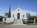 First Methodist Church in Rocksprings


References
- ^ "2019 U.S. Gazetteer Files". United States Census Bureau. Retrieved August 7, 2020.
- ^ a b "Population and Housing Unit Estimates". United States Census Bureau. May 24, 2020. Retrieved May 27, 2020.
- ^ a b "U.S. Census website". United States Census Bureau. Retrieved January 31, 2008.
- ^ "US Board on Geographic Names". United States Geological Survey. October 25, 2007. Retrieved January 31, 2008.
- ^ "Find a County". National Association of Counties. Retrieved June 7, 2011.
- ^ a b "Geographic Identifiers: 2010 Census Summary File 1 (G001): Rocksprings town, Texas". American Factfinder. U.S. Census Bureau. Archived from the original on February 13, 2020. Retrieved March 25, 2016.
- ^ Rosales, Francisco A. Chicano!: The History of the Mexican American Civil Rights Movement. Arte Publico Press, 1997. pp 29.
- ISBN 9781477310366.
- ^ Cox, Mike. Texas Disasters: True Stories of Tragedy and Survival. Globe Pequot Press, Sep. 2006. pp 99-108.
- ^ "US Gazetteer files: 2010, 2000, and 1990". United States Census Bureau. February 12, 2011. Retrieved April 23, 2011.
- ^ Climate Summary for Rocksprings, Texas
- ^ "U.S. Climate Normals Quick Access – Station: Rocksprings, TX". National Oceanic and Atmospheric Administration. Retrieved May 7, 2023.
- ^ "NOAA Online Weather Data – NWS San Antonio". National Weather Service. Retrieved May 7, 2023.
- ^ "Census of Population and Housing". Census.gov. Retrieved June 4, 2015.
- ^ "Explore Census Data". data.census.gov. Retrieved May 19, 2022.
- ^ https://www.census.gov/ [not specific enough to verify]
- ^ "About the Hispanic Population and its Origin". www.census.gov. Retrieved May 18, 2022.
Municipalities and communities of Edwards County, Texas, United States | ||
|---|---|---|
| Town |  | |
| CDP | ||
| Other community | ||
| ||