
Petrovaradin
Petrovaradin
Петроварадин (Serbian) | |
|---|---|
Town | |
   .JPG) From top: Panoramic view of Petrovaradin's Podgrađe, Belgrade's Gate, The Our Lady of Snow Ecumenic Church, Petrovaradin Fortress | |
|
UTC+2 (CEST) | |
| Postal code | 21131 |
| Area code | +381 21 |
| Vehicle registration | ns |
Petrovaradin (Serbian Cyrillic: Петроварадин, pronounced [petroʋarǎdiːn]) is a historic town in the Serbian province of Vojvodina, now a part of the city of Novi Sad. As of 2011, the urban area has 14,810 inhabitants.[1] Lying on the right bank of the Danube, across the main part of Novi Sad, it is built around the Petrovaradin Fortress, the historical anchor of the modern city.
Name
Petrovaradin was founded by the Celts, but its original name is unknown. During Roman administration it was known as Cusum. After the Romans conquered the region from the Celtic tribe of Scordisci, they built the Cusum fortress where present Petrovaradin Fortress now stands. In addition, the town received its name from the Byzantines, who called it Petrikon or Petrikov (Πετρικον) and who presumably named it after Saint Peter.
In documents from 1237, the town was first mentioned under the name Peturwarod (Pétervárad), which was named after Hungarian lord
Today, the municipality is known in Serbian as Петроварадин, in Hungarian as Pétervárad, and in German as Peterwardein.
Geography
Petrovaradin is located in the
History
Human settlement in the territory of present-day Petrovaradin has been traced as far back as the Stone Age (about 4500 BC). This region was conquered by Celts (in the 4th century BC) and Romans (in the 1st century BC).
The Celts founded the first fortress at this location. It was part of the tribal state of the Scordisci, which had its capital in Singidunum (present-day Belgrade). During the Roman administration, a larger fortress was built (in the 1st century) with the name Cusum and was included into Roman Pannonia. Subsequently, the fortress was included into the Pannonia Inferior and the Pannonia Secunda. In the 5th century, Cusum was devastated by the invasion of the Huns.
The town was then conquered by
Later, the town became part of the Kingdom of Hungary.
Between 1522 and 1526, Petrovaradin was a base for the early Ŝajkaš regiments, but in 1526, the Ottoman Empire took Petrovaradin after a two-week battle waged against combined forces of Croats, Serbs and Hungarians.
In the war of 1683–1699 with the
In 1695, a military force of Serbs—600 infantry and 200 cavalry—under Captain Pane Božić were brought to Petrovaradin to serve. One thousand Serbs worked on the construction of the Citadel and fortifications under the guidance of
During Hungarian administration, the town was firstly part of the Bolgyán County and then part of the Syrmia County, while during Ottoman administration, it was firstly part of the vassal duchy of Syrmia ruled by Serb duke Radoslav Čelnik (1527–1530), and then part of the Sanjak of Syrmia.
During the Ottoman administration, Petrovaradin had 200 houses and three mosques. There was also a Christian quarter with 35 houses populated with Croats.

Petrovaradin was the site of a notable battle on August 5, 1716 in which the Habsburg monarchy led by the Prince Eugene of Savoy defeated the forces of the Ottomans led by the Silahdar Damat Ali Pasha. Habsburg forces led by Prince Eugene later defeated the Ottomans at Belgrade before the Ottomans sued for peace at Požarevac.
During the Habsburg administration, Petrovaradin was part of the Habsburg Military Frontier (Slavonian general command - Petrovaradin regiment). In 1848–49, the town was part of Serbian Vojvodina, but in 1849, it was returned under the administration of the Military Frontier. With the abolishment of the Military Frontier in 1881, the town was included into the Syrmia County of Croatia-Slavonia, which was the autonomous kingdom within Austria-Hungary.
In 1918, the town firstly became part of the
Settlements and neighborhoods

Neighborhoods and parts of Petrovaradin are:
Between 2002 and 2019, Petrovaradin had a status of separate municipality within the city of Novi Sad, but its administrative bodies were never established and the status was mostly formal. Apart from the town, the municipality covered the area on the right Danube bank: town of
Demographics
This article needs to be updated. (January 2012) |

In 1961 Petrovaradin had 8,408 inhabitants; in 1971 10,477; in 1981 10,338; in 1991 11,285; and in 2002 13,973. By city's registry estimation, from mid-2005, Petrovaradin town had 15,266 inhabitants.[3]
Ethnic groups
- Municipality
According to the 2011 census, the total population of the territory of present-day Petrovaradin municipality was 33,865, of whom 27,328 (80.69%) were ethnic Serbs. All settlements in the municipality have an ethnic Serb majority.
- Town
| Ethnic group | 1991 | % | 2002 | % |
|---|---|---|---|---|
| Serbs | 5,643 | 50% | 9,708 | 69.48% |
| Croats | 2,236 | 19.81% | 1,364 | 9.76% |
| Yugoslavs | 1,893 | 16.78% | 779 | 5.58% |
| Hungarians | 431 | 3.82% | 396 | 2.83% |
Montenegrins
|
250 | 2.22% | 228 | 1.63% |
| Ruthenians | 148 | 1.31% | 141 | 1.01% |
| Other | 653 | 5.79% | 1,357 | 9.71% |
| Total | 11,285 | - | 13,973 | - |
During the Ottoman administration, Petrovaradin was mostly populated by Muslims, while some Serbs lived there as well in the Christian quarter. According to Habsburg census from 1720, inhabitants of Petrovaradin mostly had German and Serbo-Croatian names and surnames.[4] During the subsequent period of the Habsburg administration and in the first part of the 20th century, the largest ethnic group in the Petrovaradin town were ethnic Croats. According to the 1910 census the town had 5,527 residents, of which 3,266 spoke Croatian (59.09%), 894 German (16.18%), 730 Serbian (13.21%), 521 Hungarian (9.43%) and 159 Slovak (2.88%).[5] Since 1971 census, largest ethnic group in Petrovaradin are Serbs. Today, there are a couple of neighborhoods with sizable number of Croats in Petrovaradin, like Stari Majur and Podgrađe Tvrđave.
Economy
The following table gives a preview of total number of employed people per their core activity (as of 2017):[6]
| Activity | Total |
|---|---|
| Agriculture, forestry and fishing | 163 |
| Mining | 12 |
| Processing industry | 1,081 |
| Distribution of power, gas and water | 114 |
| Distribution of water and water waste management | 610 |
| Construction | 373 |
| Wholesale and retail, repair | 1,206 |
| Traffic, storage and communication | 333 |
| Hotels and restaurants | 198 |
| Media and telecommunications | 115 |
| Finance and insurance | 15 |
| Property stock and charter | 3 |
| Professional, scientific, innovative and technical activities | 280 |
| Administrative and other services | 86 |
| Administration and social assurance | 174 |
| Education | 384 |
| Healthcare and social work | 2,252 |
| Art, leisure and recreation | 181 |
| Other services | 117 |
| Total | 7,687 |
Politics
Between 1980 and 1989, Petrovaradin was a municipality within the city of Novi Sad. From 1989 to 2002, Novi Sad's municipalities were abolished and territory of the former Petrovaradin municipality was part of Novi Sad municipality, which included the whole territory of the present-day City of Novi Sad. The city municipalities of Novi Sad were formally re-established in 2002, with Petrovaradin as the second one, since it was a requirement to obtain a city status at the time. In 2007, after the update of the law of local government, the requirement for multiple municipalities for city status was lifted (and 20 additional
Gallery
-
 Petrovaradin fortress during EXIT festival
 -
 Petrovaradin Fortress at night
 -
 Petrovaradin
 -
 Petrovaradin railway station
 -
 Ribnjak
 -
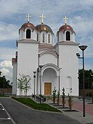
 The Our Lady of Snow Ecumenic Church
 -
 Molinari park
 -
 Serbian Orthodox Church of Saint Paul in Petrovaradin
 -
 Serbian Orthodox Church of Saint Petka in Petrovaradin
 -
 City museum in Petrovaradin
 -
 Petrovaradin, Downtown part of the Citadel
 -
 The birthplace of Ban Josip Jelačić


.JPG)


Notable people
- Anton Hasenhut (1766–1841), Austrian comic actor
- Croatian ban and army general, born in Petrovaradin.[10]
- Christian von Steeb, (1848–1921), Austrian surveyor and infantry general
- Franjo Štefanović (1879–1924), Croatian composer and writer
- Margarethe von Flindt (1880–after 1902), Austrian theater actress
- Karl Wolff (1890–1963), Austrian lawyer, university lecturer and constitutional judge
- Kosta Nađ, (1911–1986), general in the Yugoslav National Liberation Army
See also
- List of places in Serbia
- List of cities, towns and villages in Vojvodina
Notes and references
- Notes
- Petrovaradin, Enciklopedija Novog Sada, knjiga 20, Novi Sad, 2002
- Radenko Gajić, Petrovaradinska tvrđava - Gibraltar na Dunavu, Sremski Karlovci, 1993
- mr Agneš Ozer, Petrovaradinska tvrđava - vodič kroz vreme i prostor, Novi Sad, 2002
- mr Agneš Ozer, Petrovaradin Fortress - A Guide through time and space, Novi Sad, 2002
- Veljko Milković, Petrovaradin kroz legendu i stvarnost, Novi Sad, 2001
- Veljko Milković, Petrovaradin i Srem - misterija prošlosti, Novi Sad, 2003
- Veljko Milković, Petrovaradinska tvrđava - podzemlje i nadzemlje, Novi Sad, 2005
- Military Heritage did a feature about the Muslim Turks versus Christian Nobility 1716 battle and crusade at Peterwardein, and the success of Prince Eugene of Savoy (Ludwig Heinrich Dyck, Military Heritage, August 2005, Volume 7, No. 1, pp 48 to 53, and p. 78), ISSN 1524-8666.
- Henderson, Nicholas. Prince Eugene of Savoy. London: Weidenfeld and Nicolson. 1964
- Mckay, Derek. Prince Eugene of Savoy. London: Thames and Hudson. 1977
- Nicolle, David and Hook, Christa. The Janissaries. Botley: Osprey Publishing. 2000
- Setton, Kenneth M. Venice, Austria, and the Turks in the Seventeenth Century. Philadelphia: The American Philosophical Society. 1991
- References
- ^ ISBN 978-86-6161-109-4. Retrieved 2014-06-27.
- ^ "Skupština menja Statut grada, ukidaju se opštine Petrovaradin i Novi Sad" (in Serbian). 021.rs. 2019-03-25. Retrieved 2021-01-20.
- ^ City's police registry data[citation needed]
- ^ Ivan Jakšić, Iz popisa stanovništva Ugarske početkom XVIII veka, Novi Sad, 1966, pages 309-310.
- ^ Pétervárad. Révai nagy lexikona, vol. 15. p. 387. Hungarian Electronic Library. (in Hungarian).
- ^ ОПШТИНЕ И РЕГИОНИ У РЕПУБЛИЦИ СРБИЈИ, 2018. (PDF). stat.gov.rs (in Serbian). Statistical Office of the Republic of Serbia. Retrieved 17 March 2019.
- ^ Law on Territorial Organization and Local Self-Government Archived 2011-05-13 at the Wayback Machine, Parliament of Serbia (in Serbian)
- ^ "Petrovaradin - opština koje nema" (in Serbian). Radio Television of Vojvodina. 2009-04-27.
- ^ "Skupština Novog Sada izglasala novi Statut, ukinute opštine Petrovaradin i Novi Sad" [The Assembly of Novi Sad voted on the new Statute, the municipalities of Petrovaradin and Novi Sad were abolished]. Danas. 2019-03-25.
- ^ Bain, Robert Nisbet (1911). . Encyclopædia Britannica. Vol. 15 (11th ed.). pp. 314–315.
External links

| ||||||||||
| ||||||||||
| ||||||||||
| ||||||||||
| ||||||||||


| International | |
|---|---|
| National | |
| Geographic | |