
Cappadocia
Cappadocia | ||
|---|---|---|
Ancient region of Roman province Cappadocia | | |
| UNESCO World Heritage Site | |
|---|---|
 | |
| Includes | Göreme National Park, Kaymakli Underground City, Derinkuyu underground city |
| Criteria | Cultural: i, iii, v; Natural: vii |
| Reference | 357 |
| Inscription | 1985 (9th Session) |
| Area | 9,883.81 ha |
Cappadocia (/kæpəˈdoʊʃəˌ -ˈdoʊkiə/; Turkish: Kapadokya, [kɑpɑ'dokjɑ]) is a historical region in Central Anatolia, Turkey. It is largely in the provinces of Nevşehir, Kayseri, Aksaray, Kırşehir, Sivas and Niğde.
According to
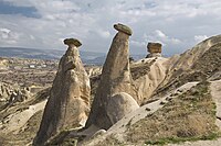
The name, traditionally used in Christian sources throughout history, continues in use as an international tourism concept to define a region of exceptional natural wonders, in particular characterized by fairy chimneys,[3] in addition to its religious heritage of being a centre of early Christian learning, evidenced by hundreds of churches and monasteries (such as those of Göreme and Ihlara), as well as underground cities that were dug to offer protection during periods of persecution.[4][5]
Etymology

The earliest record of the name of Cappadocia (
Subsequent research suggests that the adverb katta meaning 'down, below' is exclusively Hittite, while its Luwian equivalent is zanta.[7] Therefore, the recent modification of this proposal operates with the Hittite katta peda-, literally "place below" as a starting point for the development of the toponym Cappadocia.[8]
The earlier derivation from Iranian Hu-apa-dahyu 'Land of good horses' can hardly be reconciled with the phonetic shape of Kat-patuka. Several other etymologies have also been offered in the past.[9]
.jpg)

Cappadocia appears in the
The region is also mentioned in the Jewish
Under the later kings of the Persian Empire, the Cappadocians were divided into two
The kingdom of Cappadocia still existed in the time of
Geography and climate

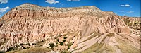
Cappadocia lies in eastern Anatolia, in the heartland of what is now Turkey. The relief consists of a high plateau over 1000 m in altitude that is pierced by volcanic peaks, with Mount Erciyes (ancient Argaeus) near Kayseri (ancient Caesarea) being the tallest at 3916 m. The boundaries of historical Cappadocia are vague, particularly towards the west. To the south, the Taurus Mountains form the boundary with Cilicia and separate Cappadocia from the Mediterranean Sea. To the west, Cappadocia is bounded by the historical regions of Lycaonia to the southwest, and Galatia to the northwest. Due to its inland location and high altitude, Cappadocia has a markedly continental climate, with hot dry summers and cold snowy winters.[16] Rainfall is sparse and the region is largely semi-arid.
Cappadocia contained the sources of the Sarus and Pyramus rivers with their higher affluents, and also the middle course of the Halys, and the whole course of the tributary of the Euphrates later called Tokhma Su. But as no one of these rivers was navigable or served to fertilize the lands along its course, none has much importance in the history of the province.[15]
Geology
Ignimbrites of Miocene age are present within the area.
IUGS geological heritage site
In respect of the 'voluminous eruption deposits in a fluvio-lacustrine sequence with 'fairy-chimney' development produced by uplift and erosion', the International Union of Geological Sciences (IUGS) included 'The Miocene Cappadocian ignimbrites sequence' in its assemblage of 100 'geological heritage sites' around the world in a listing published in October 2022. The organisation defines an IUGS Geological Heritage Site as 'a key place with geological elements and/or processes of international scientific relevance, used as a reference, and/or with a substantial contribution to the development of geological sciences through history.'[17]
History

Cappadocia was known as
Kingdom of Cappadocia
After ending the Persian Empire,
Persian colonists in the Cappadocian kingdom, cut off from their co-religionists in Iran proper, continued to practice
Under Ariarathes IV, Cappadocia came into relations with Rome, first as a foe espousing the cause of Antiochus the Great, then as an ally against Perseus of Macedon. The kings henceforward threw in their lot with the Republic as against the Seleucids, to whom they had been from time to time tributary. Ariarathes V marched with the Roman proconsul Publius Licinius Crassus Dives Mucianus against Aristonicus, a claimant to the throne of Pergamon, and their forces were annihilated (130 BC). The imbroglio which followed his death ultimately led to interference by the rising power of Pontus and the intrigues and wars which ended in the failure of the dynasty.[15][22]
Roman and Byzantine province
.jpg)

The Cappadocians, supported by Rome against
In 70 AD, Vespasian joined Armenia Minor to Cappadocia, and made the combined province a frontier bulwark. It remained, under various provincial redistributions, part of the Eastern Empire for centuries.[24]
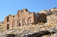
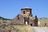
Early Christian and Byzantine periods
_Church_5.JPG)
,_Cappadocia_(Kapadokya,_Turkey)_170_(12007344575).jpg)
In 314, Cappadocia was the largest province of the Roman Empire, and was part of the Diocese of Pontus.[25] The region suffered famine in 368 described as "the most severe ever remembered" by Gregory of Nazianzus:
The city was in distress and there was no source of assistance...The hardest part of all such distress is the insensibility and insatiability of those who possess supplies...Such are the buyers and sellers of corn ... by his word and advice [basil] open the stores of those who possessed them, and so, according to the Scripture, dealt food to the hungry and satisfied the poor with bread...He gathered together the victims of the famine...and obtaining contributions of all sorts of food which can relieve famine, set before them basins of soup and such meat as was found preserved among us, on which the poor live...Such was our young furnisher of corn, and second Joseph...[But unlike Joseph, Basil's] services were gratuitous and his succour of the famine gained no profit, having only one object, to win kindly feelings by kindly treatment, and to gain by his rations of corn the heavenly blessings".[26]
This is similar to another account by Gregory of Nyssa that Basil "ungrudgingly spent upon the poor his patrimony even before he was a priest, and most of all in the time of the famine, during which [Basil] was a ruler of the Church, though still a priest in the rank of presbyters; and afterwards did not hoard even what remained to him".[26]
In 371, the western part of the Cappadocia province was divided into Cappadocia Prima, with its capital at Caesarea (modern-day Kayseri); and Cappadocia Secunda, with its capital at
The
.jpg)
Cappadocia shared an always-changing relationship with neighbouring
They [the Armenians] were assigned the Sebaste (now Siwas) district of Cappadocia. Their number grew to such an extent that they became valuable auxiliaries to the imperial armies. They were employed to garrison the fortresses reconquered from the Arabs (probably Membedj, Dolouk, etc.). They formed excellent infantry for the armies of Basileus in all wars, constantly fighting with courage and success alongside the Romans.[27]
As a result of the Byzantine military campaigns and the
Cappadocia contains several
Turkish Cappadocia

Following the
A fundamental change occurred in between when a new urban center,
Modern tourism

The area is a popular tourist destination, as it has many areas with unique geological, historic, cultural, and religious features.
Touristic Cappadocia includes four cities: Nevşehir, Kayseri, Aksaray and Niğde.
The region is located southwest of the major city Kayseri, which has airline and railway service to Ankara and Istanbul and other cities.
The most important towns and destinations in Cappadocia are Ürgüp, Göreme, Love Valley, Ihlara Valley, Selime, Guzelyurt, Uçhisar, Avanos and Zelve.
Sedimentary rocks formed in lakes and streams and

The three main castles in Cappadocia are
Mesothelioma
In 1975, a study of three small villages in central Cappadocia—Tuzköy, Karain and Sarıhıdır—found that mesothelioma was causing 50% of all deaths. Initially, this was attributed to erionite, a zeolite mineral with similar properties to asbestos, but detailed epidemiological investigation demonstrated that the substance causes the disease mostly in families with a genetic predisposition to mineral fiber carcinogenesis. The studies are being extended to other parts of the region.[31][32]
Media
The area was featured in several films due to its topography. The 1983 Italian/French/Turkish film Yor, the Hunter from the Future and 1985's Land of Doom were filmed in Cappadocia. The region was used for the 1989 science fiction film Slipstream to depict a cult of wind worshippers. In 2010 and early 2011, the film Ghost Rider: Spirit of Vengeance was also filmed in the Cappadocia region.[33]
Autechre's second album, Amber, features a photo of this region's fairy mountains as the cover art,[34] being their only album whose cover isn't computer-generated.
Cappadocia's winter landscapes and broad panoramas are prominent in the 2014 film Winter Sleep (Turkish: Kış Uykusu), directed by Nuri Bilge Ceylan, which won the Palme d'Or at the 2014 Cannes Film Festival.[35]
Sports
Since 2012, a
Gallery
-
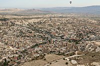 Aerial view of the town Göreme.
 -
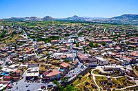 Aerial view of Uçhisar
 -
 General view of Ürgüp
 -
-

-
-
 Pigeon Valley, formerly known as Vasil Potamus
 -
-
 Balloons taking off at sunrise
 -
 Mt. Erciyes (3916 m), the highest mountain in Cappadocia
 -
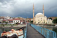
 View towards Güzelyurt Monastery Valley and Church Mosque
 -
 Cappadocia traditional houses
 -
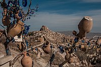 Decorated tree with Uçhisar Castle in the background.
 -
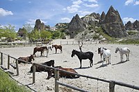 Horses roaming in Cappadocia
 -
 rock-cut architecture in Monks Valley, Paşabağ
 -
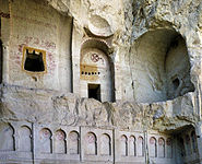 A rock-cut church in Cappadocia
 -
 Derinkuyu underground city
 -
 Kaymakliunderground city
 -
 Cappadocian Greeks in traditional clothing
 -
 Gümüşler Monastery Courtyard in Niğde
 -
 Çanlı Kilise, meaning "Bell Church" in Aksaray Province.
 -
 Kizil Kilise, meaning "Red Church" in Güzelyurt
 -
 Doors ofMustafapaşa
 -
 Architectural style of Avanos
 -
 Ortahisar castle


.jpg)

.jpeg)


.jpg)


_01.jpg)

.jpg)

See also
- Amaseia
- Ancient regions of Anatolia
- Cappadocian Fathers
- Cappadocia under the Achaemenids
- Kandovan, Iran
- Gondrani, Pakistan
- Khndzoresk, Armenia
- List of colossal sculpture in situ
- List of traditional Greek place names
- Mokissos
- Tourism in Turkey
References
- ^ [Herodotus, The Histories, Book 5, Chapter 49]
- ^ Van Dam, R. Kingdom of Snow: Roman rule and Greek culture in Cappadocia. Philadelphia: University of Pennsylvania Press, 2002, p.13. [1]
- ^ Demir, Ömer (1997). Cappadocia: Cradle of History. 16: Azim Matbaacılık. p. 15.
History, nature and mankind have created many important wonders in Cappadocia: 1- The unique natural landscape, include fairy chimneys, rock formations and valleys. 2- The rock-hewn churches decorated with frescoes from the 6th-12th C of scenes from the Bible, especially the lives of Jesus, Mother Mary and saints. 3- The undergound settlements many consider to by the 8th wonder of the ancient world.
{{cite book}}: CS1 maint: location (link) - ^ Demir, Ömer (1997). Cappadocia: Cradle of History. 16: Azim Matbaacılık. pp. 11–15, 70.
{{cite book}}: CS1 maint: location (link) - ^ a b Demir, Ömer (1997). Cappadocia: Cradle of History. 16: Azim Matbaacılık. p. 70.
However, the longest working and living period was the century when underground cities in Cappadocia were dug by Christians who could not bear Arabic and Sassanid threat after Capadocia was conquered … It is clearly visible in some underground cities in Cappadocia that the rooms located near the entrance are profoundly different from those that are inside. Saratli and Özlüce underground cities are given as an example regarding these differences.
{{cite book}}: CS1 maint: location (link) - ^ Coindoz M. Archeologia / Préhistoire et archéologie, n°241, 1988, pp. 48–59
- ^ Petra Goedegebuure, "The Luwian Adverbs zanta 'down' and *ānni 'with, for, against'", Acts of the VIIIth International Congress of Hittitology, A. Süel (ed.), Ankara 2008, pp. 299–319.
- ^ Yakubovich, Ilya (2014). Kozuh, M. (ed.). "From Lower Land to Cappadocia". Extraction and Control: Studies in Honor of Matthew W. Stolper. Chicago: Oriental Institute: 347–52.
- ^ See R. Schmitt, "Kappadoker", in Reallexikon der Assyriologie und Vorderasiatischen Archäologie, vol. 5 (Berlin: Walter de Gruyter, 1980), p. 399, and L. Summerer, "Amisos – eine Griechische Polis im Land der Leukosyrer", in: M. Faudot et al. (eds.), Pont-Euxin et polis. Actes du Xe Symposium de Vani (2005), 129–66 [135] According to an older theory (W. Ruge, "Kappadokia", in A.F. Pauly – G. Wissowa, Realencyclopädie der classischen Altertumswissenschaft, vol. 10 (Stuttgart: Alfred Druckenmüller, 1919), col. 1911), the name derives from Old Persian and means either "land of the Ducha/Tucha" or "land of the beautiful horses". It has also been proposed that Katpatuka is a Persianized form of the Hittite name for Cilicia, Kizzuwatna, or that it is otherwise of Hittite or Luwian origin (by Tischler and Del Monte, mentioned in Schmitt (1980)). According to A. Room, Placenames of the World (London: MacFarland and Company, 1997), the name is a combination of Assyrian katpa "side" (cf. Heb katef) and a chief or ancestor's name, Tuka.
- ^ Bunbury & Hogarth 1911, p. 286.
- ^ Janse, Mark (2009). "The resurrection of Cappadocian (Asia Minor Greek)". ΑΩ International.
- ^ a b "Acts 2 NIV". biblehub.com. Retrieved 2022-11-02.
- ^ "Chullin 47b:5".
- ^ Bunbury & Hogarth 1911, pp. 286–287.
- ^ a b c d e Bunbury & Hogarth 1911, p. 287.
- ^ Van Dam, R. Kingdom of Snow: Roman rule and Greek culture in Cappadocia. Philadelphia: University of Pennsylvania Press, 2002, p.14. [2]
- ^ "The First 100 IUGS Geological Heritage Sites" (PDF). IUGS International Commission on Geoheritage. IUGS. Retrieved 13 November 2022.
- ^ Map of the Achaemenid Empire
- ISBN 9783642015779.
- ^ ISBN 978-0415239028p. 85
- ^ Raditsa 1983, p. 107.
- ^ The coinage of Cappadocian kings was quite extensive and produced by highest standards of the time. See Asia Minor Coins – regal Cappadocian coins
- ^ Bunbury & Hogarth 1911, pp. 287–288.
- ^ Bunbury & Hogarth 1911, p. 288.
- ^ a b c d e f Mitchell 2018, p. 290.
- ^ a b The Hungry are Dying: Beggars and Bishops in Roman Cappadocia by Susan R. Holman
- ^ Schlumberger, Gustave Léon (1890). Un empereur byzantin au dixième siècle, Nicéphore Phocas. Paris: Firmin-Didot. pp. 250–251.
- ISBN 9780812240504.
- ISBN 978-0-52-001597-5.
- ^ Demir, Ömer (1997). Cappadocia: Cradle of History. 16: Azim Matbaacılık. p. 19.
The Christians taking shelter in the valleys of Göreme because of Arab raids, named this place 'gor emi' meaning 'you cannot see this place'. The name was changed to Korama and then to Göreme. With its very interesting fairy chimneys and the rock-cut churches, the valley of Avcılar, 17 km from Nevşehir and 6 cm from Ürgüp, attracts travellers' attention. St Paul considered Göreme to be more suitable for the training of missionaries. There are about 400 churches in the vicinity of Göreme which was one of the most important centres of Christianity between the 6th and the 9th C, including churches found in and around Zelve, Mustafapaşa, Avcılar, Uçhisar, Ortahisar and Çavuşin.
{{cite book}}: CS1 maint: location (link) - S2CID 110334356.
- S2CID 9440201.
- ^ "Cappadocia « the Spirits of Vengeance". Archived from the original on 2014-08-26. Retrieved 2012-06-18.
- ^ Palladev, George (9 February 2018). "Autechre — Amber. Short story behind the artwork". 12edit. Retrieved 15 May 2019.
- ^ Corliss, Richard. "Winter Sleep: Can a Three-Hour-Plus Prize-Winner Be Just Pretty Good?". Time. Retrieved 2017-08-15.
- ^ "Elite Athletes to run at The Runfire Cappadocia". Istanbul Convention & Visitors Bureau. July 2013. Archived from the original on 2013-08-05. Retrieved 2013-11-28.
- ^ "VİDEO | Bisiklet festivali başladı - TRT Spor - Türkiye'nin güncel spor haber kaynağı". Archived from the original on 2016-12-20. Retrieved 2016-12-14.
- This article incorporates text from a publication now in the public domain: Bunbury, Edward Herbert; Hogarth, David George (1911). "Cappadocia". In Chisholm, Hugh (ed.). Encyclopædia Britannica. Vol. 5 (11th ed.). Cambridge University Press. pp. 286–288.
Sources
- Mitchell, Stephen (2018). "Cappadocia". In Nicholson, Oliver (ed.). The Oxford Dictionary of Late Antiquity. ISBN 978-0192562463.
- Raditsa, Leo (1983). "Iranians in Asia Minor". In Yarshater, Ehsan (ed.). The Cambridge History of Iran, Vol. 3 (1): The Seleucid, Parthian and Sasanian periods. ISBN 978-1139054942.
- Weiskopf, Michael (1990). "Cappadocia". Encyclopaedia Iranica, Vol. IV, Fasc. 7–8. pp. 780–86.
- Ene D-Vasilescu, Elena, "Shrines and Schools in Byzantine Cappadocia", Journal of Early Christian History, volume 9, Issue 1, 2019, pp. 1–29
| Bronze Age | |
|---|---|
| Iron Age | |
| Classical Age | |
