
Brazoria County, Texas
Brazoria County | |
|---|---|
 The Brazoria County Courthouse in Angleton | |
|
UTC−5 (CDT) | |
| Congressional districts | 9th, 14th, 22nd |
| Website | brazoriacountytx |
Brazoria County (/brəˈzɔːriə/ brə-ZOR-ee-ə) is a county in the U.S. state of Texas. As of the 2020 census, the population of the county was 372,031.[1] The county seat is Angleton.[2]
Brazoria County is included in the Houston-The Woodlands-Sugar Land metropolitan statistical area. It is located in the Gulf Coast region of Texas.
Regionally, parts of the county are within the extreme southernmost fringe of the regions locally known as
History
Brazoria County takes its name from the Brazos River, which flows through it. Anglo-Texas began in Brazoria County when the first of Stephen F. Austin's authorized 300 American settlers arrived at the mouth of the Brazos in 1821. Many of the events leading to the Texas Revolution developed in Brazoria County. In 1832, Brazoria was organized as a separate municipal district by the Mexican government, so became one of Texas original counties at independence in 1836.
An early resident of Brazoria County, Joel Walter Robison, fought in the Texas Revolution and later represented Fayette County in the Texas House of Representatives.[3]
Stephen F. Austin's original burial place is located at a church cemetery, Gulf Prairie Cemetery, in the town of Jones Creek, on what was his brother-in-law's Peach Point Plantation. His remains were exhumed in 1910 and brought to be reinterred at the state capital in Austin. The town of West Columbia served as the first capital of Texas, dating back to prerevolutionary days.

The Hastings Oil Field was discovered by the

On June 2, 2016, the
Geography
According to the
Adjacent counties
- Harris County (north)
- Galveston County (northeast)
- Gulf of Mexico (southeast)
- Matagorda County (southwest)
- Wharton County (west)
- Fort Bend County (northwest)
National protected areas
Communities
Cities
- Alvin
- Angleton (county seat)
- Brazoria
- Brookside Village
- Clute
- Danbury
- Freeport
- Iowa Colony
- Lake Jackson
- Liverpool
- Manvel
- Oyster Creek
- Pearland (small parts in Harris and Fort Bend counties)
- Richwood
- Sandy Point
- Surfside Beach
- Sweeny
- West Columbia
Towns
Villages
Census-designated places
- Damon
- East Columbia
- Rosharon
- Ryan Acres
- Wild Peach Village
Unincorporated communities
Ghost towns
Demographics
| Census | Pop. | Note | %± |
|---|---|---|---|
| 1850 | 4,841 | — | |
| 1860 | 7,143 | 47.6% | |
| 1870 | 7,527 | 5.4% | |
| 1880 | 9,774 | 29.9% | |
| 1890 | 11,506 | 17.7% | |
| 1900 | 14,861 | 29.2% | |
| 1910 | 13,299 | −10.5% | |
| 1920 | 20,614 | 55.0% | |
| 1930 | 23,054 | 11.8% | |
| 1940 | 27,069 | 17.4% | |
| 1950 | 46,549 | 72.0% | |
| 1960 | 76,204 | 63.7% | |
| 1970 | 108,312 | 42.1% | |
| 1980 | 169,587 | 56.6% | |
| 1990 | 191,707 | 13.0% | |
| 2000 | 241,767 | 26.1% | |
| 2010 | 313,166 | 29.5% | |
| 2020 | 372,031 | 18.8% | |
| 2023 (est.) | 398,938 | [1] | 7.2% |
| U.S. Decennial Census[8] 1850–2010[9] 2010–2020[1] | |||
As of the
Of the 81,955 households in 2000, 40.80% had children under the age of 18 living with them, 62.20% were married couples living together, 10.40% had a female householder with no husband present, and 23.00% were not families. About 19.10% of all households were made up of individuals, and 6.40% had someone living alone who was 65 years of age or older. The average household size was 2.82, and the average family size was 3.23.
In the county, the age distribution as 28.60% under 18, 8.60% from 18 to 24, 32.40% from 25 to 44, 21.50% from 45 to 64, and 8.80% who were 65 or older. The median age was 34 years. For every 100 females, there were 107 males. For every 100 females age 18 and over, there were 107.4 males.
The median income for a household in the county was $48,632, and for a family was $55,282. Males had a median income of $42,193 versus $27,728 for females. The
Race and ethnicity
In the late 1800s the county was majority black as many were former slaves who had worked on plantations in the county. In 1882 it had 8,219 black people and 3,642 white people. However, after Jim Crow laws were cemented, many African-Americans moved to Houston and the county became majority white. By 2022, due to the growth of ethnic minorities in Pearland, non-Hispanic white people were now a plurality and not a majority in the county as a whole.[12]
| Race / Ethnicity | Pop 2010[13] | Pop 2020[11] | % 2010 | % 2020 |
|---|---|---|---|---|
White alone (NH)
|
166,674 | 161,833 | 53.22% | 43.50% |
Black or African American alone (NH)
|
36,880 | 53,668 | 11.78% | 14.43% |
Alaska Native alone (NH)
|
1,013 | 1,022 | 0.32% | 0.27% |
| Asian alone (NH) | 17,013 | 26,231 | 5.43% | 7.05% |
| Pacific Islander alone (NH) | 58 | 129 | 0.02% | 0.03% |
| Some Other Race alone (NH) | 472 | 1,374 | 0.15% | 0.37% |
| Mixed Race/Multi-Racial (NH) | 4,413 | 12,572 | 1.41% | 3.38% |
| Hispanic or Latino (any race) | 86,643 | 115,202 | 27.67% | 30.97% |
| Total | 313,166 | 372,031 | 100.00% | 100.00% |
Note: the U.S. Census Bureau treats Hispanic/Latino as an ethnic category. This table excludes Latinos from the racial categories and assigns them to a separate category. Hispanics/Latinos can be of any race.
In 2000, the
Government and politics
Elected officials
United States Congress
| Senators | Name | Party | First Elected | Level | |
|---|---|---|---|---|---|
| Senate Class 1 | John Cornyn | Republican | 2002 | Senior Senator | |
| Senate Class 2 | Ted Cruz | Republican | 2012 | Junior Senator | |
| Representatives | Name | Party | First Elected | Area(s) of Brazoria County Represented | |
| District 14 | Randy Weber | Republican | 2012 | Central and southern areas (Alvin), Lake Jackson, Angleton, Freeport), also part of (Galveston County) | |
| District 22 | Troy Nehls | Republican
|
2008 | Northern areas (Pearland), Northwest areas (Manvel), also parts of Harris and Galveston counties | |
Texas Legislature
Texas Senate
| District | Name | Party | First Elected | Area(s) of Brazoria County Represented | |
|---|---|---|---|---|---|
| 11 | Mayes Middleton | Republican | 1999 | Northern and central areas | |
| 17 | Joan Huffman | Republican | 2008 | Southern areas, Galveston Island and Bolivar Peninsula (Galveston County) | |
Texas House of Representatives
| District | Name | Party | First Elected | Area(s) of Brazoria County Represented | |
|---|---|---|---|---|---|
| 25 | Cody Vasut | Republican | 2020 | Lake Jackson, Angleton, Freeport | |
| 29 | Ed Thompson | Republican | 2008 | Pearland, Alvin, Manvel | |
Pearland native Kyle Kacal, a Republican from College Station, holds the District 12 state House seat based in Brazos and four neighboring counties.[14]
| Year | Republican | Democratic | Third party | |||
|---|---|---|---|---|---|---|
| No. | % | No. | % | No. | % | |
| 2020 | 90,433 | 58.35% | 62,228 | 40.15% | 2,323 | 1.50% |
| 2016 | 72,791 | 60.07% | 43,200 | 35.65% | 5,190 | 4.28% |
| 2012 | 70,862 | 66.39% | 34,421 | 32.25% | 1,456 | 1.36% |
| 2008 | 67,515 | 64.34% | 36,480 | 34.76% | 945 | 0.90% |
| 2004 | 63,662 | 68.27% | 28,904 | 31.00% | 682 | 0.73% |
| 2000 | 53,445 | 66.79% | 24,883 | 31.10% | 1,691 | 2.11% |
| 1996 | 36,392 | 55.44% | 22,959 | 34.98% | 6,287 | 9.58% |
| 1992 | 30,384 | 42.51% | 21,861 | 30.59% | 19,222 | 26.90% |
| 1988 | 34,028 | 57.60% | 23,436 | 39.67% | 1,617 | 2.74% |
| 1984 | 39,166 | 67.52% | 18,609 | 32.08% | 234 | 0.40% |
| 1980 | 27,614 | 58.08% | 18,253 | 38.39% | 1,677 | 3.53% |
| 1976 | 19,475 | 46.65% | 21,711 | 52.01% | 558 | 1.34% |
| 1972 | 21,045 | 64.89% | 11,350 | 35.00% | 37 | 0.11% |
| 1968 | 10,631 | 35.32% | 11,439 | 38.00% | 8,033 | 26.69% |
| 1964 | 8,477 | 34.60% | 15,917 | 64.98% | 103 | 0.42% |
| 1960 | 10,880 | 50.13% | 10,561 | 48.66% | 264 | 1.22% |
| 1956 | 9,536 | 56.49% | 7,137 | 42.28% | 208 | 1.23% |
| 1952 | 8,360 | 49.88% | 8,386 | 50.03% | 15 | 0.09% |
| 1948 | 2,133 | 25.51% | 4,783 | 57.19% | 1,447 | 17.30% |
| 1944 | 850 | 11.05% | 5,543 | 72.07% | 1,298 | 16.88% |
| 1940 | 799 | 17.43% | 3,781 | 82.46% | 5 | 0.11% |
| 1936 | 462 | 16.59% | 2,284 | 82.01% | 39 | 1.40% |
| 1932 | 617 | 17.25% | 2,948 | 82.44% | 11 | 0.31% |
| 1928 | 1,588 | 59.39% | 1,086 | 40.61% | 0 | 0.00% |
| 1924 | 1,114 | 37.21% | 1,761 | 58.82% | 119 | 3.97% |
| 1920 | 1,235 | 47.41% | 1,184 | 45.45% | 186 | 7.14% |
| 1916 | 581 | 33.62% | 1,033 | 59.78% | 114 | 6.60% |
| 1912 | 263 | 19.02% | 746 | 53.94% | 374 | 27.04% |
Law enforcement and jails
| Brazoria County Sheriff's Office | |
|---|---|
 | |
| Abbreviation | BCSO |
| Agency overview | |
| Formed | 1836[16] |
| Jurisdictional structure | |
| General nature | |
| Operational structure | |
| Headquarters | Angleton, Texas |
| Sheriff responsible |
|
| Website | |
| http://www.brazoria-county.com/sheriff/ | |
The Brazoria County Sheriff's Office is the oldest law enforcement agency in the State of Texas, established by the Republic of Texas in March 1836. Among its duties include running the Brazoria County Jail, located at 3602 County Road 45 in unincorporated central Brazoria County, north of Angleton.[17]

The Texas Department of Criminal Justice (TDCJ) operates six state prisons for men and its Region III office in unincorporated Brazoria County.[18] As of 2007,1,495 full-time correctional job positions were in the county.[19] In 1995, of the counties in Texas, Brazoria had the second-highest number of state prisons and jails, after Walker County.[20] In 2003, a total of 2,572 employees were employed at the six TDCJ facilities.[21] The TDCJ units are:
- Clemens Unit,[22] nearBrazoria[23]
- Memorial Unit (formerly Darrington Unit), near Rosharon - The Windham School District Region III office is within the unit.[24]
(The following 3 are co-located in Otey,[25] near Rosharon.[23])
- Ramsey Unit - The unit is co-located with Stringfellow and Terrell. The TDCJ Region III Maintenance Headquarters is within this unit.[26]
- Stringfellow Unit, near Rosharon - The unit is co-located with Ramsey and Terrell.[27] The unit was originally named Ramsey II Prison Unit.[28]
In 2007, TDCJ officials said discussions to move the Central Unit from Sugar Land to Brazoria County were preliminary.[19]
Former units:
- Retrieve Unit (later Wayne Scott Unit), near Angleton.[21][31] - Main prison closed in 2020[32]
Education
A variety of school districts serve Brazoria County students. They include:[33]
- Alvin ISD
- Angleton ISD
- Brazosport ISD
- Columbia-Brazoria ISD
- Danbury ISD
- Damon ISD
- Friendswood ISD
- Pearland ISD
- Sweeny ISD
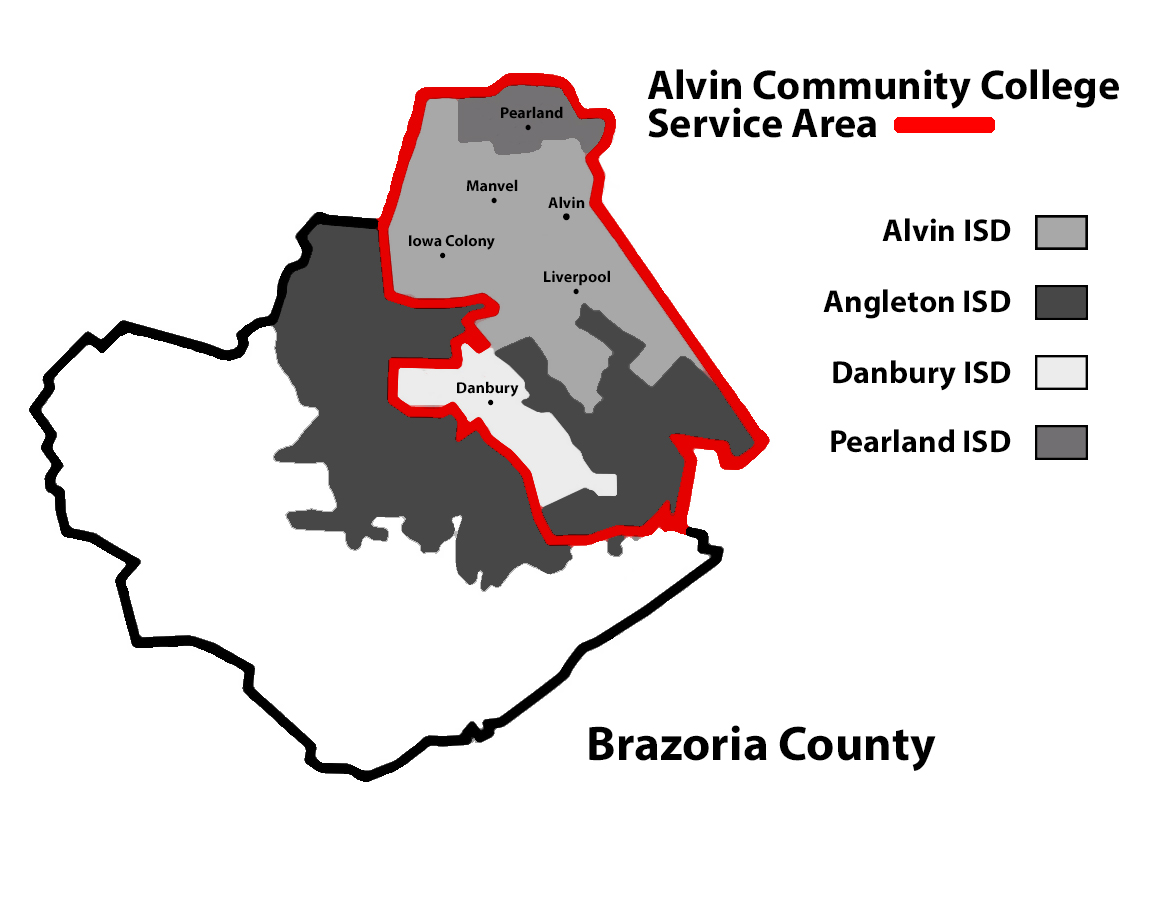
Alvin Community College and Brazosport College serve as higher education facilities. Alvin CC serves areas in Alvin, Danbury, and Pearland ISDs as well as portions of the Angleton ISD that Alvin CC had annexed prior to September 1, 1995. Brazosport College serves the remainder of Angleton ISD and the Brazosport, Columbia-Brazoria, Damon, and Sweeny ISD areas.[34]
The Brazoria County Library System has branches in Alvin, Angleton, Brazoria, Clute, Danbury, Freeport, Lake Jackson, Manvel, Pearland, Sweeny and West Columbia, and runs the Brazoria County Historical Museum.
Transportation
Major highways
- State Highway 6
- State Highway 35
- State Highway 36
- State Highway 288
- State Highway 332
Airports
The Texas Gulf Coast Regional Airport, in central unincorporated Brazoria County, is the county's sole publicly owned airport.
The following airports, located in the county, are privately owned and for public use:
- Flyin' B Airport in western unincorporated Brazoria County
- Skyway Manor Airport in Pearland
- Pearland Regional Airport in eastern unincorporated Brazoria County south of the Pearland city limits
The closest airport with regularly scheduled commercial service is Houston's William P. Hobby Airport, located in southern Houston in adjacent Harris County. The Houston Airport System has stated that Brazoria County is within the primary service area of George Bush Intercontinental Airport, an international airport in Houston in Harris County.[35]
Toll roads
| Authority overview | |
|---|---|
| Formed | December 2003[36] |
| Jurisdiction | Brazoria County, Texas |
| Headquarters | Brazoria Commissioners Court |
The Brazoria County Toll Road Authority operates toll lanes on TX 288 inside Brazoria County. They connect to the SH 288 Express Toll Lanes in Harris County operated by the Texas Department of Transportation.
History
BCTRA came into existence in December 2003
Roadway system
The only toll road BCTRA has in operation at this time is the Brazoria County Expressway. Located within the media of SH 288, the expressway begins at County Road 58 in
See also
- List of museums in the Texas Gulf Coast
- National Register of Historic Places listings in Brazoria County, Texas
- Recorded Texas Historic Landmarks in Brazoria County
References
- ^ a b c "U.S. Census Bureau QuickFacts: Brazoria County, Texas". United States Census Bureau. Retrieved November 23, 2023.
- ^ "Find a County". National Association of Counties. Archived from the original on June 15, 2011. Retrieved June 7, 2011.
- ^ "Robison, Joel Walter". Texas State Historical Association. Retrieved August 2, 2015.
- ISBN 0292760566.
- ^ Weingartner, R. (1949). Nettleton, L.L. (ed.). Geophysical Case History of the Hastings Oil Field, Brazoria and Galveston Counties, Texas, in Geophysical Case Histories, Volume 1=1948. Society of Exploration Geophysicists. pp. 156–165.
- ^ "Mandatory evacuations ordered in Brazoria County". Houston Chronicle. June 2, 2016. Retrieved July 19, 2018.
- ^ "2010 Census Gazetteer Files". United States Census Bureau. August 22, 2012. Retrieved April 19, 2015.
- US Census Bureau.
- ^ "Texas Almanac: Population History of Counties from 1850–2010" (PDF). Texas Almanac. Archived (PDF) from the original on March 19, 2013. Retrieved April 19, 2015.
- ^ "U.S. Census website". United States Census Bureau. Retrieved May 14, 2011.
- ^ a b "P2 HISPANIC OR LATINO, AND NOT HISPANIC OR LATINO BY RACE - 2020: DEC Redistricting Data (PL 94-171) - Brazoria County, Texas". United States Census Bureau.
- ^ a b c Hardy, Michael (February 18, 2022). "Brazoria County Is Poised to Elect Its First Black Congressman. Not Everyone Is Happy About It". Texas Monthly. Retrieved February 22, 2022.
- ^ "P2 HISPANIC OR LATINO, AND NOT HISPANIC OR LATINO BY RACE - 2010: DEC Redistricting Data (PL 94-171) - Brazoria County, Texas". United States Census Bureau.
- ^ "Kyle Kacal's Biography". votesmart.org. Retrieved February 23, 2014.
- ^ Leip, David. "Dave Leip's Atlas of U.S. Presidential Elections". uselectionatlas.org. Retrieved July 19, 2018.
- ^ "Brazoria County - Sheriff's Office". Archived from the original on July 16, 2009. Retrieved June 25, 2009.
- ^ "Sheriff's Office Archived September 15, 2008, at the Wayback Machine." Brazoria County. Accessed September 13, 2008.
- ^ "Region III Director's Office Archived January 25, 2010, at the Wayback Machine." Texas Department of Criminal Justice. Retrieved on January 8, 2010.
- ^ a b Lowman, John. "Talk of prison move preliminary." Brazosport Facts. Wednesday June 6, 2007. Retrieved on May 9, 2010.
- ^ Horswell, Cindy. "For hard-hit economy of Liberty County, crime officially pays." Houston Chronicle. Thursday June 29, 1995. A30. Retrieved on July 23, 2010.
- ^ a b Isensee, Bridie. "TDCJ makes overtime changes", Brazosport Facts, August 13, 2003, Retrieved May 9, 2010.
- ^ "CLEMENS (CN) Archived 2010-07-25 at the Wayback Machine." TDCJ. Accessed September 12, 2008.
- ^ a b Staff and Wire Reports. "Parts of Houston join evacuation," Houston Chronicle, September 21, 2005, Retrieved on May 10, 2010.
- ^ "DARRINGTON (DA) Archived 2010-07-25 at the Wayback Machine." TDCJ. Accessed September 12, 2008.
- ^ "Table of Contents and Excerpt, Trulson and Marquart, First Available Cell." University of Texas Press. Retrieved on July 16, 2010.
- ^ "RAMSEY (R1) Archived August 21, 2008, at the Wayback Machine." TDCJ. Accessed September 12, 2008.
- ^ "STRINGFELLOW (R2) Archived 2008-08-21 at the Wayback Machine." TDCJ. Accessed September 12, 2008.
- ^ Tompkins, John. "Ramsey unit renamed." Brazosport Facts. November 10, 2006. Retrieved on December 7, 2009.
- ^ "C. T. TERRELL (R3) Archived 2010-07-25 at the Wayback Machine." TDCJ. Accessed September 12, 2008.
- ^ Timms, Ed. "Uneasy about death row, Terrell wants name off unit Prison expected to be renamed." The Dallas Morning News. July 14, 2001. Retrieved on May 9, 2010. "Another prison the Ramsey III unit in Brazoria County probably will be renamed for Mr Terrell".
- ^ "SCOTT (RV) Archived 2008-09-24 at the Wayback Machine." TDCJ. Accessed September 12, 2008.
- The Brazosport Facts. Clute, Texas. Retrieved February 19, 2023.
- ^ Texas Education Code, Sec. 130.163. ALVIN COMMUNITY COLLEGE DISTRICT SERVICE AREA. Sec. 130.170. BRAZOSPORT COLLEGE DISTRICT SERVICE AREA.. The college zone map of Alvin ISD shows what was annexed before September 1, 1995.
- ^ "Master Plan Executive Summary Archived July 11, 2011, at the Wayback Machine." George Bush Intercontinental Airport Master Plan. Houston Airport System. December 2006. 2-1 (23/130). Retrieved on December 14, 2010.
- ^ a b "Brazoria County Creates Toll Authority : Texas County Progress". Archived from the original on August 19, 2014. Retrieved January 31, 2018.
- ^ "Brazoria County Expressway". Retrieved May 28, 2017.
- ^ Fresh drive: This is what the new 288 toll road looks like for one of the first drivers Click2Houston.com (KPRC-TV) Published on November 12, 2020, and updated on November 16, 2020 (Retrieved November 22, 2020)
External links
- Brazoria County government
- Brazoria County Day website
- Brazoria County FireFighters Association
- Brazoria County Museum
- Brazoria County Parks Department
- Brazoria County, Texas from the Handbook of Texas Online
- Brazoria County from the Texas Almanac
- Brazoria County from the TXGenWeb Project
- Historic materials about Brazoria County, hosted by the Portal to Texas History
Places adjacent to Brazoria County, Texas | ||||||||||||||||
|---|---|---|---|---|---|---|---|---|---|---|---|---|---|---|---|---|
| ||||||||||||||||
| Counties |  | |
|---|---|---|
| "Principal" cities | ||
| Other cities |
For a complete listing, see list of cities and towns in Houston–The Woodlands–Sugar Land MSA | |
| Unincorporated areas | ||
| Bodies of water | ||
 | ||||
| Towns | ||||
Villages | ||||
| CDPs | ||||
| Other communities | ||||
Ghost towns |
| |||
| Footnotes | ‡This populated place also has portions in an adjacent county or counties | |||
| ||||
| International | |
|---|---|
| National | |
| Geographic | |
| Other | |