Oenoanda
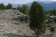
 The Greco-Roman theatre in Oenoanda | |
| Alternative name | Oinoanda |
|---|---|
| Location | İncealiler, Muğla Province, Turkey |
| Region | Lycia |
| Type | Settlement |
| History | |
| Associated with | Diogenes |


Oenoanda or Oinoanda (
The ruins of the city lie on a high isolated site west of the modern village İncealiler in the Fethiye district of Muğla Province, Turkey, which partly overlies the ancient site.
The place name suggests that it was known for viticulture.[1]
History
The early history of the settlement is obscure, in spite of an exploratory survey carried out, with permission of the Turkish authorities, by the British Institute at Ankara (BIAA) in 1974–76.[2]
The city was known as Wiyanawanda by the Hittites.[3] It means "rich in vines/wine" or semantically "land of the wine".[4] During the Bronze Age it was a part of the Lukka lands which corresponds to Lycia from classical antiquity.
It seems that Oenoanda became a colony of
Diogenes, a rich and influential citizen of Oenoanda, had a summary of the philosophy of
It was occupied into the Byzantine period when a fortress and churches were built.
Oenoanda is a
The Site

The site was first noted by Richard Hoskyn and Edward Forbes, in 1841, and published in 1842.[10] The extensive philosophical inscriptions of Diogenes of Oenoanda were identified later from scattered fragments, apparently from the stoa.[11]
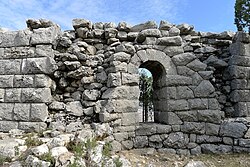
The city walls are well preserved and stand to 10m in places. The Hellenistic city wall is over 65m long and is a superb example of polygonal masonry with small stones on the interior faces while large ashlars were used for the imposing exterior faces.[12]
Part of an aqueduct can be seen in terms of stone pipe sections from a siphon.
Evidence for an ancient Roman Bridge at Oinoanda surfaced in the 1990s.[13]
Official excavations at the site started only in 1997.
By 2012 over 300 fragments of Diogenes' stoa had been identified, varying in size from a few letters to passages of several sentences covering more than one block.[16]
Remains of a screw wine press were also discovered in a house which could prove that the activity suggested in the place name continued to be practised into the late history of the city.
Notable people
- Lucius Septimius Flavianus Flavillianus (3rd century AD), Roman army member
References
- ^ "The Oinoanda campaign of 2012 Archived 2013-07-01 at the Wayback Machine", German Archaeological Institute (DAI) website (accessed 27 June 2014)
- ^ Alan Hall, "The Oenoanda Survey: 1974-76", Anatolian Studies 26 (1976:191-197).
- ^ Özdemir, Bilsen Şerife (2016). Tlos Tanrıları ve Kültleri (PhD) (in Turkish). Akdeniz Üniversitesi. p. 13.
- S2CID 162386681.
- ^ Rousset D., De Lycie en Cabalide, fouilles de Xanthos X, Droz, Genève 2010
- ^ Strabo, xiii.4.17.
- ISBN 3-7001-2596-8
- ^ Hall 1976:196.
- ^ Catholic Hierarchy
- JSTOR 1797993.
- ^ C.W. Chilton, Diogenes of Oenoanda: The Fragments (1971); Hall 1976:196 note 23.
- ^ "Oinoanda". Archived from the original on 2009-02-21. Retrieved 2009-06-29.
- ^ N. P. Milner: "A Roman Bridge at Oinoanda", Anatolian Studies, 48 (1998), pp.117–123
- ^ Excavations at Oinoanda 1997: The New Epicurean Texts, Martin Ferguson Smith, Anatolian Studies, Vol. 48 (1998), pp. 125-170, British Institute at Ankara, Cambridge University Press
- ^ "Oinoanda". Archived from the original on 2009-02-21. Retrieved 2009-06-29.
- ^ "The Oinoanda campaign of 2012 Archived 2013-07-01 at the Wayback Machine", German Archaeological Institute (DAI) website (accessed 27 June 2014)

