
Sollipulli
| Sollipulli | |
|---|---|
 Aerial photograph of volcan Sollipulli, looking southeast. The dark red feature on the side of Sollipulli is the cinder cone called Chufquen which formed during the most recent eruption, about 700 years ago. | |
| Highest point | |
| Elevation | 2,282 m (7,487 ft)[1] |
| Listing | List of volcanoes in Chile |
| Coordinates | 38°58′30″S 71°31′12″W / 38.97500°S 71.52000°W[1] |
| Geography | |
 Sollipulli Location of Sollipulli in Chile | |
| Location | Southern Chile |
Southern Volcanic Zone of the Andes | |
| Last eruption | 1240 ± 50 years[1] |
Sollipulli (Spanish pronunciation:
The volcano has evolved in close contact with glacial ice. It differs from many calderas in that Sollipulli appears to have collapsed in a non-explosive manner. The age of collapse is not yet known, but it is presently filled with ice to thicknesses of 650 m (2,130 ft). The ice drains through two glaciers in the west and the north of the caldera. Sollipulli has developed on a basement formed by Mesozoic and Cenozoic geological formations.
Sollipulli was active in the
Geomorphology and geography
Sollipulli lies in the Araucanía Region, Cautín Province, Melipeuco commune.[3] The Sollipulli volcano is in the western part of the Nevados de Sollipulli mountain range, which is bordered to the north, south and east by river valleys.[4] The communes of Curarrehue, Cunco, Panguipulli, Pucón and Villarrica are in the area,[5] Melipeuco lies 20 km (12 mi) northwest.[6] The volcano is also part of the Kütralkura geopark project.[7]
Regional
Sollipulli is part of the
There are 60 volcanoes in the Southern Volcanic Zone; among these are
Local
Sollipulli is a stratovolcano,[4] which has one 4 km-wide (2.5 mi) caldera on its summit and southwest of it the 1 km-wide (0.62 mi) Alpehué crater.[6] The crater is draped by pyroclastic flow deposits, and its rim reaches a height of 200 m (660 ft).[10] The rims of the caldera rise 150 m (490 ft) above the ice in the caldera;[11] the highest summit of Sollipulli lies on the southern flank of the caldera and reaches an elevation of 2,282 m (7,487 ft) above sea level.[4] On the southern and eastern side the caldera is bordered by several lava domes.[1] The caldera most likely was not formed by a large explosive eruption, considering that no deposits from such an eruption have been found.[12] An older 5 km × 4 km-wide (3.1 mi × 2.5 mi) caldera underlies the summit caldera.[13]
The volcano is formed by
The Nevados de Sollipulli mountain chain west of the Sollipulli caldera are a chain of volcanoes which is heavily eroded. They are formed by
The flanks of the volcano are covered by
Glaciers
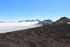
Both the main caldera and the Alpehué crater contain glaciers,[6] which in the caldera reached a thickness of 650 m (2,130 ft) in 1992[20] and fills it;[6] the total volume was estimated at 6 km3 (1.4 cu mi) in 1992.[21] These glaciers feature typical ice structures such as crevasses and there may be a subglacial lake in the caldera.[14] Three lakes are found in the caldera at its margins, the easterly Sharkfin lake, the southeasterly Dome lake and the southwesterly Alpehué lake. These glaciers drain to the north and northwest; the latter glacier flows from the caldera through the Alpehué crater into the valley of the same name,[11] which is drained by the Rio Alpehué into the Rio Allipén river.[6] Other than the caldera and crater glaciers, the only snow cover on Sollipulli is seasonal.[8] Glaciers have been present on the volcano before the Last Glacial Maximum[22] and have left glacial striations and evidence of subglacial eruptions such as hyaloclastite deposits.[23]
The glacier within the caldera of Sollipulli is shrinking;[24] its surface area decreased between 1961 and 2011 and the Alpehuén outlet glacier retreated by 1.3 km (0.81 mi).[25] Some smaller ice fields around Sollipulli either shrank between1986 and 2017 or disappeared altogether.[26] The process of glacier retreat is probably accelerated by ash being deposited on the glacier through eruptions at the neighbouring volcano Puyehue-Cordón Caulle; activity at the other volcanoes Llaima and Villarrica may have the same effect.[24] In 2011, the volume of the glacier was 4.5 ± 0.5 km3 (1.08 ± 0.12 cu mi).[8] Melting of the glacier risks generating lahars and putting water supplies in the region into jeopardy.[24]
-
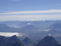 Nevados de Solipulli seen from Villarrica volcano
 -
 Sollipulli caldera viewed from space, east is up
 -
 The caldera glacier of Sollipulli
 -
 Aerial photograph of Sollipulli Caldera looking east


Geology
Subduction has been ongoing on the western side of South America since 185 million years ago and has resulted in the formation of the Andes and volcanic activity within the range. About 27 million years ago, the Farallon Plate broke up and the pace of subduction increased, resulting in increased volcanic activity and a temporary change in the tectonic regime of the Southern Andes.[9]
Sollipulli volcano developed on a 600-to-1,600-metre-high (2,000–5,200 ft) basement which consists of the
Composition
Rocks erupted from Sollipulli range from
The petrogenesis of the Alpehué rocks has been explained with the penetration of more primitive magma into a dacitic magma chamber, which was then subject to magma mixing. The primitive magmas sometimes pass through the flanks of the edifice and form parasitic vents in these cases.[31]
Obsidian was obtained on Sollipulli and exported over large distances; it has been found as far as Argentina's steppes and northern Chile,[5] and is chemically and in appearance different from obsidian obtained on Chaitén volcano. One source has been identified at a lava dome on the western side of Sollipulli.[32] A route starting south of Melipeuco leads up on the volcano; this route was used for the transport of obsidian in the 1980s.[5]
Precipitation and vegetation
Annual precipitation amounts to 2.1 metres per year (6.9 ft/a) and mostly falls between April and September.
Eruption history
Sollipulli was active during the
Radiocarbon dating at Chufquén has yielded an age of 710 ± 60 years before present.[6] This eruption deposited ash onto the caldera ice, while it is absent from the central parts of the Chufquén valley; either it was removed by a later glacier advance or it landed on a glacier which later retreated.[30] The eruption occurred relatively recently, indicating that Sollipulli is still active.[4] Presently, fumaroles and geothermal phenomena occur at the northwestern foot of Sollipulli.[49]
The 0.2 km2 (0.077 sq mi)
Hazards
The substantial ice body in the caldera means that there is a significant risk of mudflows or
The Chilean geological service
Notes
References
- ^ a b c d e "Sollipulli". Global Volcanism Program. Smithsonian Institution.
- ISSN 2411-1236.
- ^ SERNAGEOMIN. Archived from the originalon 5 October 2017. Retrieved 16 November 2017.
- ^ a b c d e Naranjo et al. 1993, p. 168.
- ^ ISSN 0718-1795. Retrieved 15 November 2017.
- ^ a b c d e f g h Gilbert et al. 1996, p. 67.
- S2CID 134884114.
- ^ a b c Lachowycz et al. 2015, p. 60.
- ^ ISSN 0716-0208.
- ^ a b c Gilbert et al. 1996, p. 73.
- ^ a b Gilbert et al. 1996, p. 69.
- ^ a b Gilbert et al. 1996, p. 81.
- ^ a b Munoz-Saez et al. 2020, p. 2.
- ^ a b c d Gilbert et al. 1996, p. 70.
- ^ Lachowycz et al. 2015, p. 76.
- ^ a b Naranjo et al. 1993, p. 170.
- ISSN 1944-9194.
- ^ Gilbert et al. 1996, p. 68,69.
- ^ a b c d Naranjo et al. 1993, p. 169.
- ISSN 1852-7744.
- ^ Gilbert et al. 1996, p. 79.
- ISSN 1851-8249.
- ^ a b c Munoz-Saez et al. 2020, p. 3.
- ^ Bibcode:2011AGUFMEP51B0846H.
- hdl:10533/130506.
- ^ Reinthaler et al. 2019, p. 551.
- ^ Naranjo et al. 1993, p. 169,170.
- ^ Munoz-Saez et al. 2020, pp. 2–3.
- ^ Gilbert et al. 1996, p. 71,72.
- ^ a b c Gilbert et al. 1996, p. 75.
- ^ Naranjo et al. 1993, p. 185.
- ^ a b Lachowycz et al. 2015, p. 62.
- ^ Gilbert et al. 1996, p. 71.
- ^ Naranjo et al. 1993, p. 173.
- ^ Moreno-Gonzalez 2022, p. 3.
- ^ Moreno-Gonzalez 2022, p. 1.
- ^ Dickson et al. 2021, p. 539.
- S2CID 233314063.
- S2CID 134334049.
- .
- S2CID 133976863.
- .
- ^ Naranjo et al. 1993, p. 177,178.
- OCLC 904547525.
- ^ Dickson et al. 2021, p. 545.
- S2CID 233937137.
- ^ Isla, Federico Ignacio (1 June 2017). "Sollipulli. El volcán cuyas cenizas definieron una frontera internacional treinta siglos después". Ciencia Hoy (in Spanish). 26 (155). Asociación Civil Ciencia Hoy: 34–38.
- S2CID 135109592.
- ^ a b c Munoz-Saez et al. 2020, p. 10.
- ^ a b Munoz-Saez et al. 2020, p. 4.
- ^ Reinthaler et al. 2019, p. 553.
- ^ Naranjo et al. 1993, p. 186.
- ISSN 0719-5370.
Sources
- Dickson, Bianca; Fletcher, Michael‐Shawn; Hall, Tegan L.; Moreno, Patricio I. (March 2021). "Centennial and millennial‐scale dynamics in Araucaria – Nothofagus forests in the southern Andes". Journal of Biogeography. 48 (3): 539. S2CID 229394729.
- Gilbert, J. S.; Stasiuk, M. V.; Lane, S. J.; Adam, C. R.; Murphy, M. D.; Sparks, R. S. J.; Naranjo, J. A. (1 September 1996). "Non-explosive, constructional evolution of the ice-filled caldera at Volcán Sollipulli, Chile". Bulletin of Volcanology. 58 (1): 67–83. S2CID 129230398.
- Lachowycz, Stefan M.; Pyle, David M.; Gilbert, Jennie S.; Mather, Tamsin A.; Mee, Katy; Naranjo, José A.; Hobbs, Laura K. (15 September 2015). "Glaciovolcanism at Volcán Sollipulli, southern Chile: Lithofacies analysis and interpretation". Journal of Volcanology and Geothermal Research. 303 (Supplement C): 59–78. .
- Moreno‐Gonzalez, Ricardo (October 2022). "Vegetation responses to past volcanic disturbances at the Araucaria araucana forest‐steppe ecotone in northern Patagonia". Ecology and Evolution. 12 (10). .
- Munoz-Saez, Carolina; Perez-Nuñez, Carolina; Martini, Sebastian; Vargas-Barrera, Alonso; Reich, Martin; Morata, Diego; Manga, Michael (15 November 2020). "The Alpehue geyser field, Sollipulli Volcano, Chile". Journal of Volcanology and Geothermal Research. 406: 107065. S2CID 224958388.
- Naranjo, Jose A.; ISSN 0718-7106.
- Reinthaler, Johannes; Paul, Frank; Granados, Hugo Delgado; Rivera, Andrés; Huggel, Christian (2019). "Area changes of glaciers on active volcanoes in Latin America between 1986 and 2015 observed from multi-temporal satellite imagery". Journal of Glaciology. 65 (252): 542–556. ISSN 0022-1430.
External links
- Sollipulli
- Pérez Núñez, C. (2019). Estudio del ambiente de formación de sínteres silíceos en los géiseres de Alpehue, volcán Sollipulli, Sur de Chile (Tesis Pregrado).