
Tata Sabaya
| Tata Sabaya | |
|---|---|
 | |
| Highest point | |
| Elevation | 5,430 m (17,810 ft)[1] |
| Coordinates | 19°08′S 68°32′W / 19.133°S 68.533°W[2] |
| Geography | |
 Tata Sabaya | |
Tata Sabaya is a 5,430-metre (17,810 ft) high
Volcanic activity at Tata Sabaya and elsewhere in the Central Volcanic Zone is the consequence of the subduction of the Nazca Plate beneath the South America Plate. The volcano has developed along a lineament that separates older crust north of the lineament from younger crust in the south, and the edifice has been formed by andesitic rocks.
The southern flank of Tata Sabaya
Geography and geomorphology
Tata Sabaya lies just north of the
Tata Sabaya is part of the
Tata Sabaya is a volcano which reaches a height of 5,430 metres (17,810 ft).
A 300-square-kilometre (120 sq mi) large deposit south of the volcano, originally interpreted as a
-
 Outline of the debris avalanche
 -
 Debris avalanche profile
 -
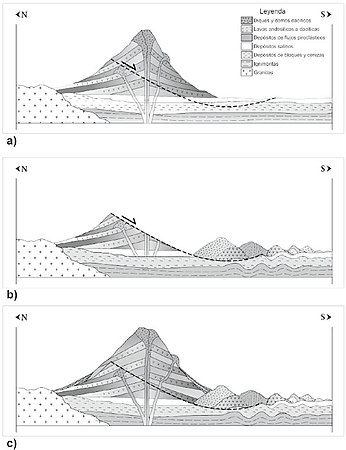 Profile of volcano development


Geology
Off the western coast of South America, the
Several phases of tectonic and volcanic activity have been identified in the Central Volcanic Zone. An earlier phase of volcanism in the Cordillera de la Costa commenced in the Jurassic but is considered separate from the Central Volcanic Zone magmatism proper. After an erosional hiatus during the Oligocene, volcanic arc activity increased during the Miocene and culminated in a phase of strong ignimbrite eruptions,[7] which originated in calderas. This phase was associated with a substantial thickening of the crust in the Central Andes. During the Pleistocene ignimbrite volcanism waned again and stratovolcanoes began to develop.[2]
Tata Sabaya lies along a crustal transition area which separates a younger crust farther south from an older (Proterozoic) crust in the north,[2] which is made up by the Chilenia terrane and the Arequipa-Antofalla craton, respectively. This transition area appears to coincide with a chain of volcanoes that Tata Sabaya is part of and which extends from Cerro Saxani in the east to Isluga in Chile, as well as with the northern end of the Pica gap where no recent volcanism occurs in the volcanic arc.[15]
The basement of the volcano is formed by the ignimbritic Altos de Pica
Composition
Tata Sabaya has produced "two-
Climate and vegetation
The region is dry with precipitation mainly falling during southern hemisphere summer, and has little vegetation cover.
Eruption history
Of all volcanoes in Bolivia, Tata Sabaya is the only one with Holocene activity which is not on the border with another country.
The earliest activity at Tata Sabaya constructed a pyroclastic shield, which crops out as a 20-metre (66 ft) thick sequence of block-and-ash flows fallout deposits and pumice deposits in the northern sector of the volcano.[15] Effusive eruptions then built up a volcanic cone on top of this shield; the five northerly lava flows were emplaced during this phase of activity. Some lava flows from this stage were unstable and collapsed, covering the northern parts of the volcano with debris.[24]
This effusive activity eventually oversteepened the cone, causing its southern sector to collapse. During this collapse and landsliding, large toreva blocks developed from sectors of the cone which slid down undeformed, while other material from the cone formed the hummocks in the sector collapse deposit;[9] there was no explosive eruption at the time of the collapse. The configuration of the deposit indicates that the debris entered the Salar when it was filled with water; the height of the tufa deposits imply that water levels were about 3,700 metres (12,100 ft) above sea level. This[10] and the lake terraces that the landslide overran marks the collapse as synchronous with the Lake Tauca episode 12,000-12,360 years ago[10][8] when water levels in the Salar de Coipasa reached their maximum.[25] The onset of such collapses on volcanoes is often determined by faulting, climate change or eruption of the volcano; at Tata Sabaya earthquakes and the injection of new magma has been invoked to explain the destabilization of the edifice.[12]
After the collapse, Holocene activity filled the scar with
Notes
- silicium.[20]
References
- ^ a b c d de Silva et al. 1993, p. 308.
- ^ a b c d e f de Silva et al. 1993, p. 307.
- ^ de Silva et al. 1993, p. 307,308.
- ^ ISSN 0375-6742.
- .
- ^ Gisbert, Teresa (1994). "El señorío de los Carangas y los chullpares del Río Lauca" (PDF) (in Spanish). Centro Bartolome de Las Casas. p. 433. Retrieved 7 February 2018.
- ^ a b de Silva et al. 1993, p. 306.
- ^ S2CID 128824938.
- ^ a b c d de Silva et al. 1993, p. 313.
- ^ a b c d e de Silva et al. 1993, p. 315.
- ^ a b Deruelle, B.; Brousse, R. (2010). ""Nuee ardente" deposits at Tata Sabaya volcano (Bolivian-Chilean Andes): Pumices and lava blocks crystallization from single magma at different depths". Revista Geológica de Chile (in Spanish) (22).
- ^ ISSN 0718-7106.
- ^ Clavero et al. 2006, p. 442.
- ^ de Silva et al. 1993, p. 305.
- ^ a b c d e de Silva et al. 1993, p. 309.
- ^ de Silva et al. 1993, p. 305,306.
- ISSN 0040-1951.
- ^ de Silva et al. 1993, p. 309,313,315.
- ^ de Silva et al. 1993, p. 315,317.
- ISBN 9783642112713
- ^ de Silva et al. 1993, p. 332.
- ISSN 1814-9332.
- S2CID 129012469.
- ^ de Silva et al. 1993, p. 312,313.
- ^ a b "Tata Sabaya". Global Volcanism Program. Smithsonian Institution.
- ^ Clavero et al. 2006, p. 439.
- ISBN 9781607322764.
Sources
- Clavero, Jorge; Pocoaca, Gabriel; Godoy, Benigno; Godoy, Estanislao; Rojas, Constanza (2006). "Influencia del sustrato en el transporte y emplazamiento de la avalancha del Volcán Tata Sabaya, Andes Centrales" (PDF). ResearchGate. 11th Chilean Geological Congress.
- de Silva, Shanaka L.; Davidson, Jon P.; Croudace, Ian W.; Escobar, Angel (March 1993). "Volcanological and petrological evolution of Volcan Tata Sabaya, SW Bolivia". Journal of Volcanology and Geothermal Research. 55 (3–4): 305–335. ISSN 0377-0273.