
Incahuasi
| Incahuasi | |
|---|---|
Ultra | |
| Coordinates | 27°01′59″S 68°17′46″W / 27.033°S 68.296°W[2] |
| Geography | |
 Incahuasi Location in Argentina, on the border with Chile | |
| Location | Catamarca, Argentina - Atacama, Chile |
| Parent range | Andes |
| Geology | |
| Mountain type | stratovolcanoes and caldera |
| Last eruption | Unknown |
| Climbing | |
| First ascent | 1913 by Walther Penck |
Incahuasi (Spanish pronunciation:
The volcano consists of a 3.5-kilometre-wide (2.2 mi) caldera and two stratovolcanoes. Four pyroclastic cones located 7 kilometres (4.3 mi) to the northeast have produced basalt-andesite lava flows that cover an area of 10 square kilometres (4 sq mi).[5]
Geography and geology
Incahuasi lies on the border between Argentina and Chile,[2] close to Paso San Francisco.[6] A major road crosses the border there.[7]
Regional
Incahuasi is part of the
Incahuasi is located northeast of
The area is dominated by volcanoes that were active after 1.5 million years ago.[13] Also located close to Incahuasi are Falso Azufre and Nevado San Francisco,[6] as well as the Miocene Cerro Morocho and Cerro Ojo de Las Lozas volcanoes.[14] It has been suggested that a perpendicular chain of volcanoes including Ojos del Salado may be the consequence of the Juan Fernández Ridge subducting in the Peru–Chile Trench.[15]
Geological evidence suggests that volcanism in the area dates back to the
Local
Incahuasi is formed by a caldera 3.5 kilometres (2.2 mi) wide. Two coalesced stratovolcanoes formed within the caldera[2] and have a diameter of 15 kilometres (9.3 mi).[17] A 6-by-4-kilometre-wide (3.7 mi × 2.5 mi) lava dome is located on the eastern flank.[17] The volcano has a volume of about 231 cubic kilometres (55 cu mi)[18] and covers a surface area of about 207 square kilometres (80 sq mi).[19] With a height of 6,621 metres (21,722 ft), Incahuasi is the 12th-highest mountain in South America[20] and one of the world's highest volcanoes.[19]
Incahuasi has two craters, a summit crater and an arcuate crater on the eastern slope that contains a lava dome.[2] The summit crater has dimensions of 750 by 900 metres (2,460 ft × 2,950 ft)[17] and is embedded within a 2-kilometre-high (1.2 mi) summit plateau.[14] Subsidiary vents conversely are associated with fissure vents.[21] The edifice appears to consist of two overlapping volcanoes.[22]
The western and southwestern slopes of Incahuasi are dotted with lava domes,
7 kilometres (4.3 mi) northeast of Incahuasi, four
-
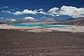 Incahuasi is the volcano at the left and El Fraile immediately right. The green lake is Laguna Verde
 -
 Incahuasi from Las Grutas. The eastern lava domes and the northeastern monogenetic volcanoes are clearly visible.


Composition
Like many Andean volcanoes, Incahuasi has erupted
The four cones northeast of the principal volcano have erupted
The occurrence of such basic magmas in a volcanic setting dominated by dacites appears to be a consequence of local tectonics, which involve the extension of the crust compared to the compressional regime farther west.[13] Originating in the mantle, the magmas quickly ascended in faults and were contaminated by crustal material.[6] The mantle itself had been modified before by crustal material added by delamination of the lower crust and subduction erosion.[32]
Climate
Incahuasi does not have glaciers,[26] but it does have at least temporary snowpack.[2] Even the crater does not support the development of glaciers.[33]
Average precipitation at Incahuasi is about 300–500 millimetres per year (12–20 in/year). The volcano lies south of the so-called "Arid Diagonal", and most precipitation falls during winter.[26] This aridity is caused by the rain shadow effect of the Subandean Ranges, which block moisture from the Atlantic Ocean.[34]
Eruption history
One andesitic lava flow on the northwestern slope of Incahuasi has yielded two ages, one of 1.15 ± 0.5 million years ago and another of 710,000 ± 80,000 years ago.[35] Based on their preservations, the lava flows appear to be of roughly comparable ages.[17] Additional ages were obtained on the main edifice, 1.57 ± 0.1 million years ago, 1.14 ± 0.37 million years ago, and 1.00 ± 0.13 million years ago.[36]
Parasitic cones were active over 500,000 years ago.[31] These include the lava dome and lava flow fields (760,000 ± 90,000 and 740,000 ± 50,000 years ago, respectively) and a lava flow from the pyroclastic cones, which has been dated to 350,000 ± 30,000 years ago.[36]
Volcanic activity at Incahuasi may have continued into the
-
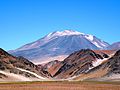
 View from Las Grutas
 -


Climbing history
The mountain was first climbed by
Archaeology
In 1913, an Inca ceremonial structure was found on the summit of Incahuasi.[20] Another archaeological site, "Fiambalá-1", lies at its foot.[42] Other Inca archaeological sites in the region appear to have had functions correlated to that of the Incahuasi site.[43]
See also
- List of volcanoes in Chile
- List of volcanoes in Argentina
- List of Ultras of South America
- Ojos del Salado
- Nevado Tres Cruces
- Cerro El Muerto
References
- ^ a b "Argentina and Chile North: Ultra-Prominences" Peaklist.org. Retrieved 2013-02-25.
- ^ a b c d e f g h i j k l m "Nevado de Incahuasi". Global Volcanism Program. Smithsonian Institution.
- ^ Diccionario Quechua - Español - Quechua, Academía Mayor de la Lengua Quechua, Gobierno Regional Cusco, Cusco 2005 (Quechua-Spanish dictionary)
- ^ Teofilo Laime Ajacopa, Diccionario Bilingüe Iskay simipi yuyayk'ancha, La Paz, 2007 (Quechua-Spanish dictionary)
- ^ "Nevado de Incahuasi Volcano, Chile/Argentina | John Seach".
- ^ a b c d e Kay, Coira & Mpodozis 2008, p. 163.
- ^ Gspurning, Lazar & Sulzer 2006, p. 60.
- ^ a b Grosse et al. 2018, p. 2.
- ^ Grosse et al. 2018, p. 3.
- ^ Gonzalez-Ferran, Baker & Rex 1985, p. 434.
- ^ a b Kay, Coira & Mpodozis 2008, p. 160.
- ^ Kay, Mpodozis & Gardeweg 2014, p. 310.
- ^ a b Kay, Coira & Mpodozis 2008, p. 162.
- ^ a b c Grosse et al. 2018, p. 11.
- ^ Gonzalez-Ferran, Baker & Rex 1985, p. 425.
- ^ Grosse et al. 2020, p. 2.
- ^ a b c d e f Grosse, P.; Orihashi, Y.; Guzman, S.; Petrinovic, I. (2014). "Volcanismo Cuaternario en la Zona del Paso San Francisco, Catamarca". conicet.gov.ar (in Spanish).
- ^ Aravena, Diego; Villalón, Ignacio; Sánchez, Pablo (April 2015). "Igneous Related Geothermal Resources in the Chilean Andes" (PDF). pangea.stanford.edu. p. 5.
- ^ a b Grosse et al. 2018, p. 10.
- ^ a b Rundel & Kleier 2014, p. 3.
- ISSN 2173-6537.
- ^ ISSN 0717-7305. Archived from the original(PDF) on 30 August 2021. Retrieved 20 August 2021.
- ^ Gonzalez-Ferran, Baker & Rex 1985, p. 436.
- ^ a b Grosse et al. 2018, p. 18.
- ^ a b c Gspurning, Lazar & Sulzer 2006, p. 61.
- ^ Grosse et al. 2020, p. 4.
- ^ Grosse et al. 2020, p. 8.
- ^ Grosse et al. 2020, p. 16.
- ^ Grosse et al. 2018, p. 7.
- ^ ISSN 0718-7106.
- ^ Kay, Mpodozis & Gardeweg 2014, p. 324.
- ^ Gspurning, Lazar & Sulzer 2006, p. 63.
- ^ Gonzalez-Ferran, Baker & Rex 1985, p. 435.
- ^ a b Grosse et al. 2018, p. 12.
- ISBN 9780444531179.
- ISSN 0717-7305. Archived from the original(PDF) on 2017-04-02. Retrieved 2017-04-01.
- ^ Grosse et al. 2018, p. 19.
- ISSN 2610-3540.
- ^ Echevarria, Evelio (1987). "Early British Ascents in the Andes (1831-1946)" (PDF). Alpine Journal: 64–65.
- S2CID 163533551.
- ISSN 1045-6635.
Sources
- Gonzalez-Ferran, O.; Baker, P.E.; Rex, D.C. (March 1985). "Tectonic-volcanic discontinuity at latitude 27° south Andean Range, associated with Nazca Plate Subduction". Tectonophysics. 112 (1–4): 423–441. .
- Grosse, Pablo; Orihashi, Yuji; Guzmán, Silvina R.; Sumino, Hirochika; Nagao, Keisuke (1 May 2018). "Eruptive history of Incahuasi, Falso Azufre and El Cóndor Quaternary composite volcanoes, southern Central Andes". Bulletin of Volcanology. 80 (5): 44. S2CID 134869390.
- Grosse, Pablo; Ochi Ramacciotti, María Luisa; Escalante Fochi, Florencia; Guzmán, Silvina; Orihashi, Yuji; Sumino, Hirochika (1 September 2020). "Geomorphology, morphometry, spatial distribution and ages of mafic monogenetic volcanoes of the Peinado and Incahuasi fields, southernmost Central Volcanic Zone of the Andes". Journal of Volcanology and Geothermal Research. 401: 106966. S2CID 225294953.
- Gspurning, Josef; Lazar, Reinhold; Sulzer, Wolfgang (2006). "Regional Climate and Snow/Glacier Distribution in Southern Upper Atacama (Ojos del Salado) - an integrated statistical, GIS and RS based approach" (PDF). Grazer Schriften der Geographie und Raumforschung. 41: 59–70.
- Kay, Suzanne Mahlburg; Coira, Beatriz; Mpodozis, Constantino (2008-01-01). Field trip guide: Neogene evolution of the central Andean Puna plateau and southern Central Volcanic Zone. Vol. 13. pp. 117–181. )
- Kay, Suzanne Mahlburg; Mpodozis, Constantino; Gardeweg, Moyra (2014-01-01). "Magma sources and tectonic setting of Central Andean andesites (25.5–28°S) related to crustal thickening, forearc subduction erosion and delamination". Geological Society, London, Special Publications. 385 (1): 303–334. S2CID 129489335.
- Rundel, Philip W.; Kleier, Catherine C. (2014). "Parque Nacional Nevado de Tres Cruces, Chile: A Significant Coldspot of Biodiversity in a High Andean Ecosystem" (PDF). fs.fed.us.
- Valero-Garcés, Blas; Delgado-Huertas, Antonio; Ratto, Norma; Navas, Ana; Edwards, Larry (2000-09-01). "Paleohydrology of Andean saline lakes from sedimentological and isotopic records, Northwestern Argentina". Journal of Paleolimnology. 24 (3): 343–359. S2CID 129052389.
External links
- "Incahuasi". SummitPost.org.
- Incahuasi (in Spanish)
- "Cerro de Incahuasi, Argentina/Chile" on Peakbagger