
Catskill Mountains
| Catskill Mountains | |
|---|---|
Appalachians , with the Catskills as "C"
| |
| Country | United States |
| State | Sedimentary |
The Catskill Mountains, also known as the Catskills, are a
Geologically, the Catskills are a mature dissected plateau, a flat region subsequently uplifted and eroded into sharp relief by watercourses. The Catskills form the northeastern end of the Allegheny Plateau (also known as the Appalachian Plateau).[1][2]
The Catskills were named by early Dutch settlers. They are well known in American society as the setting for films and works of art, including many 19th-century Hudson River School paintings, as well as for being a favored destination for vacationers from New York City in the mid-20th century. The region's many large resorts gave many young stand-up comedians an opportunity to hone their craft. Since the late 19th century, the Catskills have been a haven for artists, musicians and writers, especially in and around the towns of Woodstock and Phoenicia.
History
Etymology

.jpg)
Nicolaes Visscher I's 1656 map of New Netherland located the Landt van Kats Kill at the mouth of Catskill Creek. The region to the south is identified as Hooge Landt van Esopus (High Lands of the Esopus), a reference to a local band of northern Lenape Native Americans who inhabited the banks of the Hudson and hunted in the highlands along the Esopus Creek.[3]
While the meaning of the name ("cat creek [
The confusion over the origins of the name led over the years to variant spellings such as Kaatskill and Kaaterskill, both of which are also still used: the former in the regional magazine
Geography
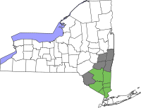
The Catskill Mountains are approximately 100 miles (160 km) north-northwest of New York City and 40 miles (64 km) southwest of Albany, starting west of the Hudson River. The Catskills occupy much of two counties (Greene and Ulster), and extend slightly into Delaware, Sullivan, and southwestern Schoharie counties.
At the range's eastern end, the mountains begin dramatically with the Catskill Escarpment rising up suddenly from the Hudson Valley. The western boundary is far less certain, as the mountains gradually decline in height and grade into the rest of the Allegheny Plateau, but maps from the 18th and 19th centuries consistently mark the border of the Catskill Mountains as the East Branch of the Delaware River, which is consistent with the actual topographic relief.[5] The Pocono Mountains, to the immediate southwest in Pennsylvania, are also a part of the Allegheny Plateau.
The Catskills contain

Climatically, the Catskills lie within the Allegheny Highlands forests ecoregion.
Climate
According to the
| Climate data for Phoenicia, Ulster County NY. Elevation: 900 ft (274 m) | |||||||||||||
|---|---|---|---|---|---|---|---|---|---|---|---|---|---|
| Month | Jan | Feb | Mar | Apr | May | Jun | Jul | Aug | Sep | Oct | Nov | Dec | Year |
| Mean daily maximum °F (°C) | 34.4 (1.3) |
37.9 (3.3) |
47.4 (8.6) |
60.8 (16.0) |
71.0 (21.7) |
79.9 (26.6) |
83.4 (28.6) |
82.3 (27.9) |
75.1 (23.9) |
62.8 (17.1) |
51.0 (10.6) |
39.4 (4.1) |
60.4 (15.8) |
| Daily mean °F (°C) | 26.9 (−2.8) |
29.1 (−1.6) |
36.5 (2.5) |
50.5 (10.3) |
60.1 (15.6) |
68.9 (20.5) |
74.3 (23.5) |
71.8 (22.1) |
66.4 (19.1) |
51.0 (10.6) |
41.3 (5.2) |
30.5 (−0.8) |
49.4 (9.7) |
| Mean daily minimum °F (°C) | 18.1 (−7.7) |
20.0 (−6.7) |
27.8 (−2.3) |
40.5 (4.7) |
51.4 (10.8) |
57.9 (14.4) |
62.9 (17.2) |
61.0 (16.1) |
56.3 (13.5) |
42.6 (5.9) |
32.9 (0.5) |
22.9 (−5.1) |
38.4 (3.6) |
| Average precipitation inches (mm) | 3.6 (91) |
3.98 (101) |
3.82 (97) |
4.0 (100) |
3.9 (99) |
3.2 (81) |
2.6 (66) |
2.9 (74) |
3.02 (77) |
3.6 (91) |
3.7 (94) |
3.5 (89) |
46.33 (1,177) |
| Average relative humidity (%)
|
69.1 | 66.2 | 59.2 | 55.8 | 60.8 | 67.4 | 70.8 | 70.0 | 71.0 | 69.7 | 69.9 | 69.3 | 66.0 |
| Source: PRISM Climate Group[7] | |||||||||||||
| Climate data for Margaretville, Delaware County, NY. Elevation: 1,000 ft (300 m) | |||||||||||||
|---|---|---|---|---|---|---|---|---|---|---|---|---|---|
| Month | Jan | Feb | Mar | Apr | May | Jun | Jul | Aug | Sep | Oct | Nov | Dec | Year |
| Mean daily maximum °F (°C) | 34.8 (1.6) |
38.3 (3.5) |
47.7 (8.7) |
61.0 (16.1) |
71.4 (21.9) |
80.1 (26.7) |
83.8 (28.8) |
82.4 (28.0) |
75.4 (24.1) |
63.0 (17.2) |
51.5 (10.8) |
39.8 (4.3) |
60.8 (16.0) |
| Daily mean °F (°C) | 27.1 (−2.7) |
29.2 (−1.6) |
36.9 (2.7) |
50.0 (10.0) |
60.2 (15.7) |
69.0 (20.6) |
74.4 (23.6) |
71.9 (22.2) |
66.6 (19.2) |
51.4 (10.8) |
41.8 (5.4) |
30.8 (−0.7) |
49.8 (9.9) |
| Mean daily minimum °F (°C) | 18.4 (−7.6) |
20.1 (−6.6) |
28.0 (−2.2) |
40.1 (4.5) |
51.9 (11.1) |
58.0 (14.4) |
63.5 (17.5) |
61.4 (16.3) |
56.4 (13.6) |
42.9 (6.1) |
33.1 (0.6) |
23.2 (−4.9) |
38.8 (3.8) |
| Average precipitation inches (mm) | 3.6 (91) |
3.63 (92) |
3.8 (97) |
4.0 (100) |
3.9 (99) |
3.2 (81) |
2.5 (64) |
2.9 (74) |
3.0 (76) |
3.6 (91) |
3.63 (92) |
3.5 (89) |
46.32 (1,177) |
| Average relative humidity (%)
|
68.5 | 64.3 | 58.5 | 55.8 | 61.6 | 67.4 | 70.9 | 70.2 | 71.7 | 69.9 | 68.5 | 69.8 | 66.0 |
| Source: PRISM Climate Group[7] | |||||||||||||
| Month | Jan | Feb | Mar | Apr | May | Jun | Jul | Aug | Sep | Oct | Nov | Dec | Year |
|---|---|---|---|---|---|---|---|---|---|---|---|---|---|
| Average Dew Point °F
|
16.2 | 17.7 | 24.3 | 34.3 | 48.6 | 57.8 | 63.2 | 61.7 | 55.8 | 41.9 | 32.2 | 22.1 | 38.9 |
| Average Dew Point °C
|
-8.8 | -7.9 | -4.6 | 1.1 | 7.6 | 13.6 | 16.2 | 15.9 | 12.1 | 5.5 | 0.1 | -5.5 | 3.8 |
Source: PRISM Climate Group[7]
| |||||||||||||
Geology

Although the Catskills are sometimes compared with the
The Catskill Mountains are more of a
The uplift and erosion of the Acadian Mountains was occurring during the

Over time, the sediments were buried by more sediments from other areas, until the original Devonian and Mississippian sediments were deeply buried and slowly became solid rock. Then the entire area experienced uplift, which caused the sedimentary rocks to begin to erode. Today, those upper sedimentary rocks have been completely removed, exposing the Devonian and Mississippian rocks. Today's Catskills are a result of the continued erosion of these rocks, both by streams and, in the recent past, by glaciers.
In successive
Recreation
The Borscht Belt
In the mid–20th century, summer resorts in the Catskills, nicknamed the Borscht Belt, were a major vacation destination for Jewish New Yorkers. At its peak of popularity, about 500 resorts operated in the region.[10] Later changes in vacationing patterns have led most of those travelers elsewhere, although there are still some bungalow communities and summer camps in the region catering to Orthodox populations.
Aquatic sports and recreation

The Ashokan Reservoir is part of the New York City water supply system, with fishing allowed under permit, but swimming and most other recreational uses are forbidden.
River canoeing and kayaking are popular. There are 42 rapids ranging from class I to V+.[11]
The Esopus Creek is famous for its
Cycling
Road and mountain biking are fairly popular in the range. Bicycle racing includes the Tour of the Catskills, a three-day road stage race held in Green and Ulster counties each summer,[13] and the UCI Mountain Bike World Cup in Windham.[14] Other cycling resources include the Catskill Scenic Trail, the Headwaters Trails in Stamford and the Roundtopia trail network (mapped by the Round Top Mountain Bike Association).[15] Several ski centers provide downhill mountain bicycling in the warmer months.
Hiking and camping
Within the range is the
Skiing
There are five main downhill ski and snowboard areas in the Catskills:
.The Mountain Trails Cross Country Ski Center in Tannersville has 22 miles (35 km) of trails.
Structures
This section needs additional citations for verification. (December 2017) |
Fire towers

The Catskill Mountains
- Balsam Lake Mountain Fire Observation Station near Hardenburgh, elevation 3,723 ft (1,135 m)
- Hunter Mountain Fire Tower near Hunter, elevation 4,042 ft (1,232 m)
- Mt. Utsayantha Fire Tower near Stamford, New York, elevation 3,214 ft (980 m)
- Overlook Mountain Tower near Woodstock, elevation 3,140 ft (960 m)
- Red Hill Fire Observation Station near Denning, elevation 2,990 ft (910 m)
- Mount Tremper Fire Observation Station near Shandaken, elevation 2,740 ft (840 m)
- Upper Esopus Fire Observation Station near Mount Tremper, elevation 678 ft (207 m)
Notable landmarks
The
.Transportation
From 1872, the northern part of the Catskills were served by the Catskill Mountain Branch of the
The southern part of the Catskills was served by the New York, Ontario and Western Railway. Over the course of 1950, service on the NYO&W downscaled to summer only. In its last years it ran trains from Roscoe to Weehawken, New Jersey, via Liberty. It connected with the New York Central's West Shore Railroad at Cornwall.[17][18] This service lasted until September 10, 1953.[19]
The
The Catskills are accessible by automobile from the east along
The closest major airports to the Catskill region are Albany International Airport to the north and Stewart International Airport in Newburgh to the south. Smaller airports in the region include:
- Columbia County Airport in Hudson
- Dutchess County Airport in Poughkeepsie
- Joseph Y. Resnick Airport in Ellenville
- Kingston–Ulster Airport
- Kobelt Airport in Wallkill
- Middletown
- Sullivan County International Airport in Monticello
- Wurtsboro–Sullivan County Airport
In popular culture
The Catskills serve as the setting for many works of fiction, such as the short story Rip Van Winkle, and the children's book My Side of the Mountain. The Hudson Valley Film Commission maintains a list of films set in the Hudson Valley/Catskills Region.[20] Of them, more than three dozen films are set in the Catskills.
The town of Bethel, New York, located in the Catskills, was home to the famous Woodstock music festival that took place August 15–18, 1969. The event, wherein 32 music acts performed in front of over 500,000 concert-goers, was captured in the documentary movie Woodstock (1970). The site is now home to the world-renowned Bethel Woods Center for the Arts.
The many hotels and vacation resorts located in the Catskills are notable in American cultural history for their role in the development of modern stand-up comedy. Comedians such as Rodney Dangerfield, Jackie Mason, Alan King, and Don Rickles all got their start performing in Catskill hotel venues colloquially referred to as the Borscht Belt.[21]
- Gallery of paintings and photographs
-
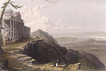 View from The Mountain House (1836), painting by William Henry Bartlett
 -
 Paul Weber, Scene in the Catskills, 1858
 -
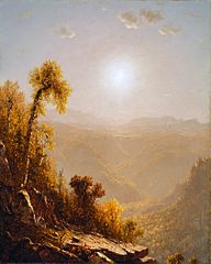 October in the Catskills, 1880 painting by Sanford Robinson Gifford
 -
![The Catskills, 1859 painting by Asher Brown Durand depicting the Catskills using the "sublime landscape" approach[22]](//upload.wikimedia.org/wikipedia/commons/thumb/2/2b/Asher_Brown_Durand_-_The_Catskills_-_Walters_37122.jpg/193px-Asher_Brown_Durand_-_The_Catskills_-_Walters_37122.jpg) The Catskills, 1859 painting by Asher Brown Durand depicting the Catskills using the "sublime landscape" approach[22]
The Catskills, 1859 painting by Asher Brown Durand depicting the Catskills using the "sublime landscape" approach[22] -
 The Redmond Stage, Woodstock music festival, 1969
 -
 Kaaterskill Falls on the Catskill Mountains (1826–27), painting by William Guy Wall, Honolulu Museum of Art


![The Catskills, 1859 painting by Asher Brown Durand depicting the Catskills using the "sublime landscape" approach[22]](/File:Asher_Brown_Durand_-_The_Catskills_-_Walters_37122.jpg)


See also
References
- ^ "REGIONAL TOPOGRAPHY". Catskills GIS Atlas. Catskill Center. Archived from the original on October 29, 2009. Retrieved October 12, 2009.
- ^ "Physiographic divisions of the conterminous U. S". U.S. Geological Survey. Retrieved December 6, 2007.
- ISBN 978-1-930098-02-2.
- ^ "The Elusive Mountain Lion – E-Files – Our History". Sierra Club. Archived from the original on August 7, 2007. Retrieved September 17, 2007.
- ^ "Search results - NYPL Digital Collections".
- ^ "USDA Interactive Plant Hardiness Map". United States Department of Agriculture. Retrieved July 9, 2019.
- ^ a b c "PRISM Climate Group, Oregon State University". www.prism.oregonstate.edu. Retrieved July 9, 2019.
- ^ "Geology of National Parks, 3D and Photographic Tours". USGS. USGS. Retrieved August 6, 2018.
- S2CID 19940868.
- ^ Stanley Turkel (August 1, 2019). "Hotel History: Catskill Mountain Resort Hotels". Hospitality Net.
- ^ "Whitewater Rivers in and near the Catskill Mountains, New York". Retrieved May 10, 2013.
- ^ DePalma, Anthony (June 15, 2009). "An Unsightly Algae Extends Its Grip to a Crucial New York Stream". The New York Times. Retrieved May 28, 2019.
- ^ "Tour of the Catskills". Anthem Sports. Retrieved December 18, 2013.
- ^ "Windham Mountain Bike World Cup Festival". Archived from the original on March 26, 2016. Retrieved December 18, 2013.
- ^ "The trail system". Round Top Mountain Bike Association. October 20, 2019.
The Round Top trail system evolved from the local riding scene of the 90s.
- ^ "Catskill Interpretive Center". Retrieved October 18, 2017.
- ^ 'Official Guide of the Railways,' January 1950, New York, Ontario and Western section
- ^ Official Guide of the Railways, December 1950, New York, Ontario and Western section, page reproduced at http://www.thejoekorner.com/brochures/nyow-og-timetable/index.html
- ^ American Rails, 'New York, Ontario and Western Railway' https://www.american-rails.com/nyow.html
- ^ "Woodstock Film Commission". Hudsonvalleyfilmcommission.org. Archived from the original on September 22, 2013. Retrieved March 26, 2014.
- ^ "Comedians who became stars learned their craft in Catskill Mountain hotels". tribunedigital-sunsentinel. Archived from the original on December 29, 2015. Retrieved January 14, 2016.
- The Walters Art Museum.
Further reading
- Heilprin, Angelo (1907). "The Catskill Mountains". Bulletin of the American Geographical Society. 39 (4): 193–201. JSTOR 198709.
- McIntosh, Robert P. (1962). "The forest cover of the Catskill Mountain region, New York, as indicated by land survey records". American Midland Naturalist. 68 (2): 409–23. JSTOR 2422746.
- McIntosh, Robert P. (1972). "Forests of the Catskill Mountains, New York". Ecological Monographs. 42 (2): 143–61. JSTOR 1942261.
- McIntosh, R. P.; R. T. Hurley (1964). "The spruce-fir forests of the Catskill Mountains". Ecology. 45 (2): 314–26. JSTOR 1933844.
- Rich, John Lyon (1906). "Local glaciation in the Catskill Mountains". The Journal of Geology. 14 (2): 113–21. S2CID 129029014.
- Shepard, Paul (1957). "Paintings of the New England landscape: a scientist looks at their geomorphology". College Art Journal. 17 (1): 30–43. JSTOR 773655.
- ISBN 9781101875889.
- Weathers, K. C.; G. M. Lovett; G. E. Likens; R. Lathrop (2000). "The effect of landscape features on deposition to Hunter Mountain, Catskill Mountains, New York". Ecological Applications. 10 (2): 528–40. ISSN 1051-0761.
External links
- . Encyclopædia Britannica. Vol. 5 (11th ed.). 1911.
- Hiking Guide to Catskill High Peaks—Catskill 3500 Club
- List of Catskills peaks organized by hiking difficulty
- Website for the Catskill Mountain Club hiking
- The Catskill Archive – History of the Catskill Mountains
- The Catskill Mountain Foundation
- The Catskill Center
- The Catskill Watershed Corporation
- Catskill Region Photo Gallery
- Catskill Mountainkeeper—Protecting the Six Counties of the Catskills
- Catskill Mountain Businesses listed on Hudson Valley Directory
- Sullivan County Visitors Association

| Counties |  | |
|---|---|---|
| Major cities | ||
| Cities and towns over 100,000 | ||
| Cities and towns over 25,000 |
| |
| Regions |
| |
| See also | ||
| |||||||||
| |||||||||
| International | |
|---|---|
| National | |