
Template:Transclude list item excerpts as random slideshow/testcases/Portal:Lithuania
limits in MediaWiki; see the HTML comment "NewPP limit report" in the rendered page. to examine the results of template uses. You can also use Special:ExpandTemplates You can test how this page looks in the different skins and parsers with these links: |
Portal maintenance status: (June 2018)
automated editing software. Learn how to update the maintenance information here . |
Introduction


Lithuania (/ˌlɪθjuˈeɪniə/ ⓘ LITH-yoo-AYN-ee-ə; Lithuanian: Lietuva [lʲɪɛtʊˈvɐ]), officially the Republic of Lithuania (Lithuanian: Lietuvos Respublika [lʲɪɛtʊˈvoːs rʲɛsˈpʊblʲɪkɐ]), is a country in the Baltic region of Europe. It is one of three Baltic states and lies on the eastern shore of the Baltic Sea. It borders Latvia to the north, Belarus to the east and south, Poland to the south, and Russia to the southwest, with a maritime border with Sweden to the west. Lithuania covers an area of 65,300 km2 (25,200 sq mi), with a population of 2.86 million. Its capital and largest city is Vilnius; other major cities are Kaunas, Klaipėda, Šiauliai and Panevėžys. Lithuanians belong to the ethnolinguistic group of the Balts and speak Lithuanian, one of only a few living members of the Baltic branch of the Indo-European language family, which is also the most widely spoken language of the branch.
For millennia, the southeastern shores of the Baltic Sea were inhabited by various
Lithuania is a developed country with a high income, advanced economy, ranking 35th in the Human Development Index. Lithuania is a member of the European Union, the Council of Europe, the eurozone, the Nordic Investment Bank, the Schengen Agreement, NATO, and OECD. It also participates in the Nordic-Baltic Eight (NB8) regional co-operation format. (Full article...)
Selected pictures
-
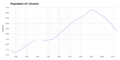 Population of Lithuania 1915–2014 (from Lithuania)
 -
 Lithuanian cemetery at All Souls night (from Culture of Lithuania)
 -
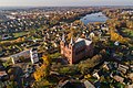
 Vilnius University, one of the oldest universities in the region. It was established by Stephen Báthory, King of Poland and Grand Duke of Lithuania, in 1579. (from Lithuania)
 -

-

-
 Commemoration of the Act of the Re-Establishment of the State of Lithuania in the historical Seimas hall where it was originally signed in 1990. The ceremony is attended by the Lithuanian President, Prime Minister, Chairman of the Seimas and other high-ranking officials. (from Lithuania)
 -

-
-
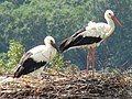 The white stork is the national bird of Lithuania, which has the highest-density stork population in Europe. (from Lithuania)
 -
-

-
 Lithuania has longlasting beer brewing traditions. (from Lithuania)
 -
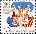 1960 postage stamp depicting Lithuanians intraditional clothing (from Culture of Lithuania)
 -
-
 Lithuanian armoured train Gediminas 3, used in Lithuanian Wars of Independence and Lithuanian soldiers (from Lithuania)
 -
 Yellow, green, and red horizontally shape the flag of Lithuania (from Culture of Lithuania)
 -
 Statutes of Lithuania were the central piece of Lithuanian law in 1529–1795. (from Lithuania)
 -
 A proportional representation of Lithuania's exports, 2019 (from Lithuania)
 -

-
 A Lithuanian folklore band Kūlgrinda performing in Vilnius (from Culture of Lithuania)
 -

-
 scythemen during the 1831 uprising (from Lithuania)
 -
 Kaunas Clinics, a medical institution in Lithuania (from Lithuania)
 -
 Lithuania's name in writing (Litua, on line 7), 1009 (from Lithuania)
 -

-
 Rock band Antis, which under firm censorship actively mocked the Soviet Union regime by using metaphors in their lyrics, during an Anti-Sovietism, Anti-communism concert in 1987 (from Lithuania)
 -
-

-

-
 Real GDP per capita development of Estonia, Latvia and Lithuania (from Lithuania)
 -

-

-
 Palace of the Grand Dukes of Lithuania in Vilnius, marked 6, in 1600 (from Lithuania)
 -
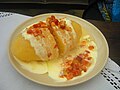 Cepelinai, a potato-based dumpling dish characteristic of Lithuanian cuisine with meat, curd or mushrooms (from Lithuania)
 -

-
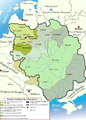 Changes in the territory of Lithuania from the 13th to 15th century. At its peak, Lithuania was the largest state in Europe. Lithuania's strength was its toleration of various cultures and religions. (from Lithuania)
 -
-
 Grand Dukes and capital city of the medieval state (from Lithuania)
 -
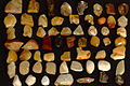 Baltic amber was once a valuable trade resource. It was transported from the region of modern-day Lithuania to the Roman Empire and Egypt through the Amber Road. (from Lithuania)
 -
-
-
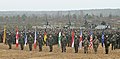
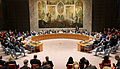 Lithuania was recently a member of the United Nations Security Council. Its representatives are on the right side. (from Lithuania)
 -
 Physical map and geomorphological subdivision of Lithuania (from Lithuania)
 -
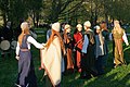
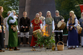 A ceremony of Lithuanian modern pagans. (from Culture of Lithuania)
 -
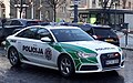 Lithuanian police cruiser in Gediminas Avenue, Vilnius (from Lithuania)
 -
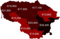 Lithuanian counties by GDP per capita, 2022 (from Lithuania)
 -
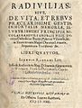 The title page of Radivilias (1592, Vilnius). The poem celebrating commander Mikalojus Radvila Rudasis (1512–1584) and recounts the famous victory of Lithuanian Armed Forces over Moscow troops (1564). (from Lithuania)
 -
-
 The first Lithuanian printed book, Catechism of Martynas Mažvydas (1547, Königsberg) (from Lithuania)
 -
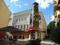
 Nasdaq Vilnius Stock Exchange, located in K29 business centre in Konstitucijos Avenue, Vilnius (from Lithuania)
 -

-
 Simple Words of Catechism by Martynas Mažvydas was the first Lithuanian book and was published in 1547. (from Culture of Lithuania)
 -

-
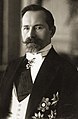
 Bishop Motiejus Valančius resisted Russification. He urged protest against the closing of Catholic churches and organised book printing in Lithuanian in Lithuania Minor. (from Lithuania)
 -
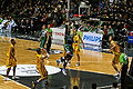
 FIBA Rankings. (from Lithuania)
 -
 Population density of Lithuania (from Lithuania)
 -
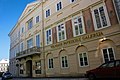 The Picture Gallery in Vilnius' Chodkiewicz Palace (from Culture of Lithuania)
 -
 Lyduvėnai Bridge, the highest (42 m.) and the longest (599 m.) railway bridge in the Baltics (from Lithuania)
 -
 interbellum Lithuania (1919–1920, 1926–1940). (from Lithuania)
 -

-
 Onwar crimes. (from Lithuania)
 -
-
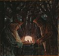
 Lithuanian artistavant-garde cinema (from Culture of Lithuania)
 -

-
 The original 20 members of the Council of Lithuania after signing the Act of Independence of Lithuania, 16 February 1918 (from Lithuania)
 -
 Kings' Fairy Tale (1908–1909) by Mikalojus Konstantinas Čiurlionis (from Lithuania)
 -
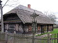 Gryčia (traditional dwelling house, built in the 19th century) (from Lithuania)
 -
![Image 68The earliest known Lithuanian glosses (between 1520 and 1530) written in the margins of Johann Herolt book Liber Discipuli de eruditione Christifidelium. Words: teprÿdav[ſ]ʒÿ (let it strike), vbagÿſte (indigence). (from Lithuania)](//upload.wikimedia.org/wikipedia/commons/thumb/f/f6/The_earliest_known_Lithuanian_glosses_%28~1520%E2%80%931530%29%2C_words_%28tepridau%C5%BEia%2C_ubagyst%C4%97%29.jpg/120px-The_earliest_known_Lithuanian_glosses_%28~1520%E2%80%931530%29%2C_words_%28tepridau%C5%BEia%2C_ubagyst%C4%97%29.jpg) The earliest known Lithuanian glosses (between 1520 and 1530) written in the margins of Johann Herolt book Liber Discipuli de eruditione Christifidelium. Words: teprÿdav[ſ]ʒÿ (let it strike), vbagÿſte (indigence). (from Lithuania)
The earliest known Lithuanian glosses (between 1520 and 1530) written in the margins of Johann Herolt book Liber Discipuli de eruditione Christifidelium. Words: teprÿdav[ſ]ʒÿ (let it strike), vbagÿſte (indigence). (from Lithuania) -

-
-

-
 Lithuania's GDP per capita compared to rest of the world (2022) (from Lithuania)
 -
-
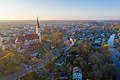
 Utena (from List of cities in Lithuania)
 -
-

-
-
 Violeta Urmanavičiūtė, a Lithuanian soprano singer. (from Culture of Lithuania)
 -
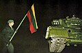
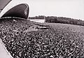 AnAnti-Soviet rally in Vingis Park of about 250,000 people. Sąjūdis was a movement which led to the restoration of an Independent State of Lithuania. (from Lithuania)
 -

-
 FSRU Independence in port of Klaipėda (from Lithuania)
 -

-
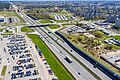
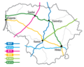 Major highways in Lithuania (from Lithuania)
 -
 The Baltic Way was a mass anti-Soviet demonstration where approx. 25% of the population of the Baltic states participated. (from Lithuania)
 -
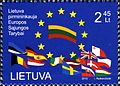 Stamp dedicated to Lithuania's presidency of the European Union. Post of Lithuania, 2013. (from Lithuania)
 -
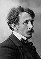 Painter and composer M.K. Čiurlionis (from Lithuania)
 -
-
 Lituanica above New York in 1933. The transatlantic flight was one of the most precise in aviation history. It equaled, and in some aspects surpassed, Charles Lindbergh's classic flight. (from Lithuania)
 -

-
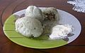 Cepelinai served with sour cream (from Culture of Lithuania)
 -

-
 The victory of theMuscovites at the Battle of Orsha in 1514 (from Lithuania)
 -
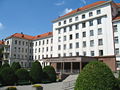
 Vilnius University Life Sciences Center in the Sunrise Valley (from Lithuania)
 -
 Vytautas the Great in the centre (from Lithuania)
 -
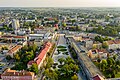
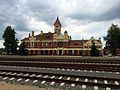 Marijampolė railway station, completed in 1924 (from Lithuania)
 -

-
 Soldiers of the Red Army enter the territory of Lithuania during the first Soviet occupation in 1940. (from Lithuania)
 -
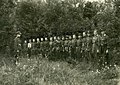 Lithuanian resistance fighters. The armed resistance was 50,000 strong at its peak. (from Lithuania)
 -
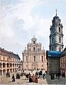 The Great Courtyard of Vilnius University and the Church of St. Johns (from Culture of Lithuania)
 -


.jpg)


.jpg)


_(2).jpg)
.svg)


.jpg)


.jpg)


.jpg)


.jpg)

.PNG)
.jpg)


_by_Martynas_Ma%C5%BEvydas,_published_in_K%C3%B6nigsberg,_1547_(cropped).jpg)


_-_1909.jpg)

![Image 68The earliest known Lithuanian glosses (between 1520 and 1530) written in the margins of Johann Herolt book Liber Discipuli de eruditione Christifidelium. Words: teprÿdav[ſ]ʒÿ (let it strike), vbagÿſte (indigence). (from Lithuania)](/File:The_earliest_known_Lithuanian_glosses_(~1520%E2%80%931530),_words_(tepridau%C5%BEia,_ubagyst%C4%97).jpg)
_(48099215538).jpg)


.png)


.jpg)
.png)


.jpg)

.jpg)
,_Bitwa_pod_Orsz%C4%85.jpg)


.jpg)


.jpg)


.svg)
.png)


