
Dardanelles
| Dardanelles | |
|---|---|
| Strait of Gallipoli | |
| Çanakkale Boğazı ( Turkish Straits | |
| Basin countries | Turkey |
| Max. length | 61 km (38 mi) |
| Min. width | 1.2 km (0.75 mi) |


The Dardanelles (
One of the world's narrowest straits used for
Most of the northern shores of the strait along the Gallipoli peninsula (Turkish: Gelibolu) are sparsely settled, while the southern shores along the Troad peninsula (Turkish: Biga) are inhabited by the city of Çanakkale's urban population of 110,000.
Names
The contemporary Turkish name Çanakkale Boğazı, meaning 'Çanakkale Strait', is derived from the eponymous midsize city that adjoins the strait, itself meaning 'pottery fort'—from چاناق (çanak, 'pottery') + قلعه (kale, 'fortress')—in reference to the area's famous pottery and ceramic wares, and the landmark Ottoman fortress of Sultaniye.
The English name Dardanelles is an abbreviation of Strait of the Dardanelles. During Ottoman times there was a castle on each side of the strait. These castles together were called the Dardanelles,[1][2] probably named after Dardanus, an ancient city on the Asian shore of the strait which in turn was said to take its name from Dardanus, the mythical son of Zeus and Electra. The name comes from the Dardani in the Balkans, according to Papazoglu.[3]
The ancient Greek name Ἑλλήσποντος (Hellēspontos) means "Sea of Helle", and was the ancient name of the narrow strait. It was variously named in classical literature Hellespontium Pelagus, Rectum Hellesponticum, and Fretum Hellesponticum. It was so called from Helle, the daughter of Athamas, who was drowned here in the mythology of the Golden Fleece.[4]
Geography
As a
The strait is located at approximately 40°13′N 26°26′E / 40.217°N 26.433°E.
Present morphology
The strait is 61 kilometres (38 mi) long, and 1.2 to 6 kilometres (0.7 to 3.7 mi) wide, averaging 55 metres (180 ft) deep with a maximum depth of 103 metres (338 ft) at its narrowest point at
The Dardanelles is unique in many respects. The very narrow and winding shape of the strait is more akin to that of a river. It is considered one of the most hazardous, crowded, difficult and potentially dangerous waterways in the world. The currents produced by the tidal action in the Black Sea and the Sea of Marmara are such that ships under sail must wait at anchorage for the right conditions before entering the Dardanelles.
History
As part of the only passage between the Black Sea and the Mediterranean, the Dardanelles has always been of great importance from a commercial and military point of view, and remains strategically important today. It is a major sea access route for numerous countries, including
Ancient Greek, Persian, Roman, and Byzantine eras (pre-1454)
Greek and Persian history
The ancient city of
According to Herodotus (vv.34), both bridges were destroyed by a storm and
Herodotus commented that this was a "highly presumptuous way to address the Hellespont" but in no way atypical of Xerxes. (vii.35)
Harpalus the engineer is said to have eventually helped the invading armies to cross by lashing the ships together with their bows facing the current and adding two additional anchors to each ship.
From the perspective of
Byzantine history
The Dardanelles were vital to the defence of Constantinople during the Byzantine period.
Also, the Dardanelles was an important source of income for the ruler of the region. At the
... Whoever dares to violate these regulations shall no longer be regarded as a friend, and he shall be punished. Besides, the administrator of the Dardanelles must have the right to receive 50 golden Litrons, so that these rules, which we make out of piety, shall never ever be violated... ... The distinguished governor and major of the capital, who already has both hands full of things to do, has turned to our lofty piety in order to reorganize the entry and exit of all ships through the Dardanelles... ... Starting from our day and also in the future, anybody who wants to pass through the Dardanelles must pay the following:
– All wine merchants who bring wine to the capital (Constantinopolis), except
sextariusof wine.
– In the same manner, all merchants of olive-oil, vegetables and lard must pay the Dardanelles officials 6 follis. Cilician sea-merchants have to pay 3 follis and in addition to that, 1 keration (12 follis) to enter, and 2 keration to exit.
– All wheat merchants have to pay the officials 3 follis per modius, and a further sum of 3 follis when leaving.
Since the 14th century the Dardanelles have almost continuously been controlled by the Turks.
Ottoman era (1354–1922)

The Dardanelles continued to constitute an important waterway during the period of the Ottoman Empire, which conquered Gallipoli in 1354.
Ottoman control of the strait continued largely without interruption or challenges until the 19th century, when the Empire started
Nineteenth century
Gaining control of, or guaranteed access to, the strait became a key foreign-policy goal of the
In 1833, following the
This treaty alarmed the
World War I
.jpg)

In 1915 the
The Turks mined the straits to prevent Allied ships from penetrating them but, in minor actions two submarines, one British and one Australian, did succeed in penetrating the minefields. The British submarine sank an obsolete Turkish pre-dreadnought battleship off the Golden Horn of Istanbul. Sir Ian Hamilton's Mediterranean Expeditionary Force failed in its attempt to capture the Gallipoli peninsula, and the British cabinet ordered its withdrawal in December 1915, after eight months' fighting. Total Allied deaths included 43,000 British, 15,000 French, 8,700 Australians, 2,700 New Zealanders, 1,370 Indians and 49 Newfoundlanders.[8] Total Turkish deaths were around 60,000.
Following the war, the 1920
Turkish republican and modern eras (1923–present)
After the dissolution of the
As part of its national security strategy, Turkey eventually rejected the terms of the treaty, and subsequently remilitarized
During World War II, through February 1945, when Turkey was neutral for most of the length of the conflict, the Dardanelles were closed to the ships of the belligerent nations. Turkey declared war on Germany in February 1945, but it did not employ any offensive forces during the war.
In July 1946, the Soviet Union sent a note to Turkey proposing a new régime for the Dardanelles that would have excluded all nations except the Black Sea powers. The second proposal was that the straits should be put under joint Turkish-Soviet defence. This meant that Turkey, the Soviet Union, Bulgaria and Romania would be the only states having access to the Black Sea through the Dardanelles. The Turkish government however, under pressure from the United States, rejected these proposals.[9]
Turkey joined NATO in 1952, thus affording its straits even more strategic importance as a commercial and military waterway.
In more recent years,[
The Dardanelles were closed in late February 2022 to all foreign warships at the beginning of the
Crossings
Maritime
The waters of the Dardanelles are traversed by numerous passenger and vehicular ferries daily, as well as recreational and fishing boats ranging from dinghies to yachts owned by both public and private entities.
The strait also experiences significant amounts of commercial shipping traffic.
Land
The Çanakkale 1915 Bridge joins Lapseki, a district of Çanakkale, on the Asian side and Sütlüce, a village of the Gelibolu district, on the European side.[12] It is part of planned expansions to the Turkish National Highway Network. Work on the bridge began in March 2017, and it was opened on March 18, 2022.[13]
Subsea
2
Both subsea power lines cross 4 optical fibre data lines laid earlier along the strait.[14] A published map shows communication lines leading from Istanbul into the Mediterranean, named MedNautilus and landing at Athens, Sicily and elsewhere.[15]
Image gallery
-
 Marble plate with 6th century AD Byzantine law regulating payment of customs in the Dardanelles
 -
 Historic map of the Dardanelles by Piri Reis
 -
 TheANZACs at Gallipoliin 1915
 -
 Map of the Dardanelles drawn by G. F. Morrell, 1915, showing theGallipoli Campaign
 -
 A view of the Dardanelles from Gallipoli peninsula
 -
 A view of Çanakkale from the Dardanelles
 -

-
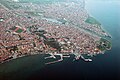 Aerial view of the city of Çanakkale
 -
 Dardanelles in 2021
 -
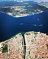 The narrowest section of the Dardanelles


See also
- Action of 26 June 1656
- Battle of the Dardanelles (disambiguation)
- Dardanelles Commission
- List of maritime incidents in the Turkish Straits
References
- OCLC 1193061215. Archivedfrom the original on 24 October 2017.
- OCLC 1158045075.
- ^ Papazoglu, F. (1978). The Central Balkan Tribes in Pre-Roman Times: Triballi, Autariatae, Dardanians, Scordisci and Moesians. Niederlande: Hakkert, p. 132
- ^ One or more of the preceding sentences incorporates text from a publication now in the public domain: Chisholm, Hugh, ed. (1911). "Hellespont". Encyclopædia Britannica. Vol. 13 (11th ed.). Cambridge University Press. p. 246.
- ISBN 90-247-3464-9. Retrieved 1 August 2017.
- ^ Aeschylus. "The Persians". Translated by Potter, Robert. Archived from the original on 19 November 2003. Retrieved 26 September 2003 – via The Internet Classics Archive.
- ISBN 0-520-20573-1.
- ^ "Gallipoli casualties by country". New Zealand History. New Zealand Ministry for Culture and Heritage. 1 March 2016. Retrieved 6 November 2020.
- OCLC 1088163662.
- ^ "Groundbreaking ceremony for bridge over Dardanelles to take place on March 18". Hürriyet Daily News. 17 March 2017. Retrieved 19 March 2017.
- ^ "Project Information". 1915 Çanakkale Bridge. Retrieved 21 March 2022.
- ^ "Turkey opens record-breaking bridge between Europe and Asia". CNN. 18 March 2022. Retrieved 19 March 2022.
- ^ Yüce, Gülnazi (7–8 June 2016). Submarine Cable Projects (2-03) (PDF). First South East European Regional CIGRÉ Conference. Portorož, Slovenia. Archived from the original (PDF) on 9 April 2018. Retrieved 8 April 2018.
- ^ "Submarine Cable Map 2017". TeleGeography. Archived from the original on 28 September 2017. Retrieved 9 April 2018.
External links
- Pictures of the city of Çanakkale
- Map of Hellespont
- Livius.org: Hellespont Archived 1 September 2013 at the Wayback Machine
- Monuments and memorials of the Gallipoli campaign along the Dardanelles
- Old Maps of the Dardanelles, Eran Laor Cartographic collection, The National Library of Israel
| International | |
|---|---|
| National | |
| Geographic | |
| Other | |
| |||||||||||||||||||||
| |||||||||||||||||||||
Lists | |
|---|---|