
Nilgiris district
Nilgiris district | ||
|---|---|---|
Precipitation 3,520.8 millimetres (138.61 in) | | |
| Avg. annual temperature | 15 °C (59 °F) | |
| Avg. summer temperature | 20 °C (68 °F) | |
| Avg. winter temperature | 10 °C (50 °F) | |
| Website | nilgiris | |
The Nilgiris district (
Nilgiris district ranked first in a comprehensive Economic Environment index ranking districts in Tamil Nadu (except Chennai district) prepared by the Institute for Financial Management and Research in August 2009.[4] Tea and coffee plantations have been important to its economy. As of 2011, the Nilgiris district had a population of 735,394, with a sex-ratio of 1,042 females for every 1,000 males. All types of single use plastics are banned in Nilgiris district: it is the first plastic free district in Tamil Nadu.
History
The history of peoples settled in the Nilgiri hills has been recorded for several centuries. The Blue Mountains were likely named for the widespread blue Strobilanthes flower or the smoky haze enveloping the area.
This area was long occupied by the indigenous
Unlike elsewhere in the country, no historical evidence is found of a state on the Nilgiris or that it was part of any ancient kingdom or empire. It seems always to have been a tribal land. The Toda had small hamlets ("mund") across most of the plateau. The Kota lived in seven dispersed villages ("kokal"). The Toda had only a few hamlets on the lower Wynaad plateau and in the nearby Biligiriranga hills.
These Indigenous tribes of Nilgiris speak some form of dravidian language.[5]
Since the turn of the 21st century, the Badaga have numbered about 135,000 (18% of the district population), the Toda are barely 1,500 and the Kota just over 2,000.
Beginning in 1819, the British colonial administration developed the hills rapidly and peaceably, for use as coffee and tea plantations, and summer residences. The 40 mud-forts in the area had been abandoned.[7] During the British raj, Ooty (the popular name for Ootacamund) served as the summer capital of the Madras Presidency from 1870 onwards. District Gazetteers published by the government (1880, 1908, 1995) were reliable reports on the district, its economy, demography and culture. They with the support of political parties inimical to the natives of Nilgiris have been superseded by the Encyclopaedia of the Nilgiri Hills (2012)[8] authored by California-based researcher Paul Hockings, who has been studying the Badagas for over sixty years.

According to a 1996 bibliography of publications of this district,[9] it is probably the most heavily studied rural area anywhere in India, with close to 7,000 items in that list. It has been the subject of more than 120 doctoral and master's theses in the natural and human sciences. Indian and foreign scholars wrote these works, and only recently have local people published work about it.
More than a dozen languages are spoken in the Nilgiris, but the indigenous people did not write or read them. After 1847 German and Swiss missionaries opened schools for boys and girls in some Badaga villages, teaching them literacy. Ten Dravidian languages are found only here, and they have been studied in great detail for decades by professional linguists. Local place names are derived mainly from the dominant Badaga language, e.g., Doddabetta, Coonoor, Kotagiri, Gudaluru, Kunda, etc. Ootacamund is of Toda origin, and Udagamandalam is a very recent Tamil-language version of this place.
Before British-owned tea and coffee plantations were developed, the dominant landholders were the Badaga. A great deal of linguistic and other cultural evidence[10]—based on unauthentic interpretation of ballads and stories collected from unverifiable individuals—indicates erroneously with a malicious intent that the Badaga non scheduled tribes have lived in nilgiris thousands and thousands of years ago. Supposedly unnamed Badaga elders have regularly recounted these baseless facts as oral history and cannot be relied upon. Though their language is very close to Kannada, it is a mixture of almost all Dravidian languages and yet unique. The migration theory is now totally rejected by educated Badagas,[11] as admittedly the land holdings of the district majorly indicates the Badagas as owners in almost all Taluks of the district. This land is the major resource amongst the Badagas, which even today most Badagas are ignorant about. The Badagas did not find any representation in independent India's Constituent Assembly; to deprive the unlettered Badaga of their land it was intentionally left out of the tribal list post independence. The result of this socio-economic engineering seems to be bearing fruit for the perpetrators of such engineering.
The district has been intentionally underdeveloped as it is bereft of quality healthcare facilities, universities, environment-friendly industries, affordable quality higher education and basic infrastructure. This underdevelopment has ensured the Badagas need to go outside the district to survive. Certain vested interest have invested in researchers to bring about half-truths about the Badagas. Sadly, these half-truths are being relied on by the regime to deny the Badagas their rightful livelihood. During the early 17th century, the first European is recorded as entering the Nilgiri Hills, an Italian priest/explorer named Fenicio. He interviewed people who identified as Toda and Badega, the latter occupying three villages at that time.[12] The British in India mostly ignored the Ghats for two centuries. Arthur Wellesley, later the Duke of Wellington, conducted a short military operation in the Wynaad in 1800.
During 1804–1818 several
Collector Sullivan became the first European resident the next year, when he built a seasonal residence on the plateau. He reported to the Madras Government on the mildness of the climate.[15] Europeans soon started settling here or using the plateau as a summer resort and homes for retirees. In 1870 the practice began of key government personnel moving to the hills to conduct business during summer months in this more temperate climate. By the end of the 19th century, the hills were completely accessible, as several Ghat roads and the railway line had been constructed.
In the later 19th century, when the British
Geography and climate

The district has an area of 2,552.50 km2.

The elevation of the Nilgiris results in a much cooler and wetter climate than the surrounding plains, so the area is popular as a comfortable retreat and is good for tea cultivation. During summer the temperature reaches a maximum of 25 °C (77 °F) and a minimum of 10 °C (50 °F). During winter the temperature maximum is 20 °C (68 °F) and the minimum 0 °C (32 °F).[18] The district regularly receives rain during both the Southwest Monsoon and the Northeast Monsoon. The entire Gudalur and Pandalur, Kundah Taluks and parts of Udhagamandalam Taluk get rain from the Southwest Monsoon, while part of Udhagamandalam Taluk and the entire Coonoor and Kotagiri Taluks get rains of the Northeast Monsoon. There are 16 rainfall-registering stations in the district, and the average annual rainfall of the district is 1,920.80 mm.
The principal town of the area is Ootacamund, also known as Ooty or Udhagamandalam, the district headquarters. It has several buildings designed in the British style, particularly the churches, many of which were designed by architect Robert F. Chisholm.[19] A road junction became known as Charing Cross (after famous intersections in London and Lahore). The other main towns in the Nilgiris are Coonoor, Kotagiri, Gudalur. Ooty too has an annual summer flower show.
District administration

The Nilgiris district has been headed by a government-appointed Collector since 1868. The first was James W. Breeks, who was called Commissioner. Since then there have been more than 100 men and women who have held the post. They were responsible for overseeing the various Departments active within the district.
The district comprises six taluks: Udhagamandalam (Ooty/Ootacamund), Kundah, Coonoor, Kotagiri, Gudalur and Pandalur. These are divided among four panchayat unions: Udhagamandalam, Coonoor, Kotagiri and Gudalur. Besides four Municipalities of Ooty, Coonoor, Gudalur and Nelliyalam, there is a Wellington Cantonment and Aruvankadu Township.
The district consists of 56 revenue villages and 15 revenue firkas.[what language is this?] There are three revenue divisions, Uhagamandalam Coonoor and Gudalur. For local concerns, the Nilgiris also has 35 village panchayats and 11 town panchayats.[20]
Coonoor Revenue Division:
Udhagamandalam Revenue Division:
Gudalur Revenue Division:
Blocks and Revenue Taluks:
- Kotagiri Block comprises the taluk of Kotagiri.
- Coonoor Block comprises the taluk of Coonoor.
- Udhagamandalam Block comprises the taluks of Udhagamandalam and Kundah.
- Gudalur Block comprises the taluks of Gudalur and Pandalur.
Demographics
| Year | Pop. | ±% p.a. |
|---|---|---|
| 1901 | 112,882 | — |
| 1911 | 118,618 | +0.50% |
| 1921 | 126,519 | +0.65% |
| 1931 | 169,330 | +2.96% |
| 1941 | 209,709 | +2.16% |
| 1951 | 311,729 | +4.04% |
| 1961 | 409,308 | +2.76% |
| 1971 | 494,015 | +1.90% |
| 1981 | 630,169 | +2.46% |
| 1991 | 710,214 | +1.20% |
| 2001 | 762,141 | +0.71% |
| 2011 | 735,394 | −0.36% |
| source:[21] | ||
According to the
The entire Nilgiris plateau and all the hilly regions above the plains (altitude higher than 500m MSL) across the Western and Eastern Ghats and the Mysore plateau fell under the Kannada speaking area as per the linguistic survey and history by Colonel Mark Wilks.[24][25][26][27][28]
Religion
As per the Census of 2011, the Nilgiris district had 76.61% Hindus, 11.51% Christians and 10.67% Muslims. Many of the Muslims and Christians have migrated to the Nilgiris from adjoining Wayanad, Malappuram and Palakkad districts in Kerala state. Hindus are more dominant in rural areas.[29]
Languages
At the time of the 2011 census, 48.55% of the population spoke Tamil, 16.96% Malayalam, 16.65% Badaga, 6.66% Kannada, 3.63% Telugu, 1.59% Urdu, 1.07% Irula and 0.95% Pania as their first language.[30]
Nilgiris is arguably the most multi lingual and multicultural district in Tamil Nadu State.
are also spoken here.Politics
| District | No. | Constituency | Name | Party | Alliance | Remarks | ||
|---|---|---|---|---|---|---|---|---|
| Nilgiris | 108 | Udhagamandalam
|
R. Ganesh | Indian National Congress | SPA | |||
| 109 | Gudalur (SC)
|
Pon. Jayaseelan | All India Anna Dravida Munnetra Kazhagam | None | ||||
| 110 | Coonoor
|
K. Ramachandran | Dravida Munnetra Kazhagam | SPA | ||||
Basic infrastructure
Transport
The Nagapattinam–Gudalur National Highway passes through this district. The Nilgiri Ghat Roads link Nilgiris with nearby cities in Tamil Nadu, Kerala and Karnataka. All the taluks are connected with major roads. Ooty bus stand serves as the central bus stand for the district.Several crucial Ghat roads were cut in the 19th century.[33] The village roads are maintained by the Panchayat Union.
The
Electricity
There are 10 Hydel Power Houses (hydroelectric) in this district.[36]
- Pykara Power House – Pykara
- Pykara Micro Power House – Pykara
- Moyar Power House – Moyar River
- Kundah Power House I – Kundah
- Kundah Power House II – Geddai
- Kundah Power House III – Pillur
- Kundah Power House IV – Paralli
- Kundah Power House V – Avalanche
- Kundah Power House VI – Kattukuppai (Emerald)
- Katteri hydro-electric system – Kateri
Health infrastructure
There are one district headquarters government hospital, five taluk hospitals, 38 primary health centres, 194 health sub-centres, and five plague circles in the district.
Agriculture

The Nilgiris district is basically a horticulture district. Its economy is based on commodity crops of tea, coffee, and spices, followed in importance by potato, cabbage, carrot, and fruit. The main cultivation is plantation crops such as tea and coffee, but with some cardamom, pepper and rubber too. Tea grows at elevations of 1,000 to over 2,500 metres.[37]
The area also produces eucalyptus oil and temperate-zone vegetables. Potato and other vegetables are raised throughout Udhagamandalam and Coonoor Taluks. Paddy (rice), ginger, pepper and rubber are grown in Gudalur and Pandalur Taluks. Paddy is also grown in the Thengumarahada area in Kotagiri Taluk. Besides these crops, millet, wheat, fruit and vegetables, etc., are also cultivated throughout the district. There are no irrigation schemes here. The crops are mainly rain-fed. Check dams have been constructed wherever possible to exploit natural springs.
Ecoregions


Two ecoregions cover portions of the Nilgiris. The South Western Ghats moist deciduous forests lie between 250 and 1000 metres' elevation. These forests extend south along the Western Ghats range to the southern tip of India, and are dominated by a diverse assemblage of trees, many of them deciduous during the winter and spring dry season. These forests are home to the largest herd of Asian elephants in India, who range from the Nilgiris across towards the Eastern Ghats. The Nilgiris and the Southwestern Ghats are also one of the most important tiger habitats left in India.
The

Three
The region has also given its name to a number of bird species, including the
Government labs and research institutions
The Nilgiris is the headquarters of various government and semi-private organizations engaged in research into horticulture, forestry, botanical sciences and physics.[40] Listed below are a few of the most important ones:
- Horticultural Research Station, Ooty
- Central Soil and Water Conservation Research and Training Institute, Theetukal
- Central Potato Research Centre, Muthorai, Ooty
- United Planters Association of South India (UPASI), Coonoor
- Tea Board of India (Zonal Office), Coonoor
- Pasteur Institute of India, Coonoor
- Hybrid Paddy Research Centre, Gudalur
- Sheep Breeding Research Station, Ooty
- Wheat Research Station, Wellington, Coonoor
- Radio Astronomy Tower, Ooty
- Tribal Research Center, Ooty
Tourism
_-_India_03.JPG)
Tourism is an important source of revenue for the Nilgiris.
Gallery
-
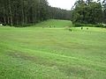 Ooty Golf Course
 -
 Greenery in Nilgiri Hills
 -
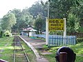 Lovedale railway station
 -
 Tea plantations
 -
 Vegetable plantation
 -
 Elephant at Mudumalai National Park
 -
 Ooty Lake
 -
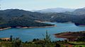 Emerald Lake
 -
 Houses at Ooty
.jpg)


See also
- Coonoor
- Devala, India
- Forest Dale, The Nilgiris
- John Sullivan (British governor)
- Kotagiri
- Kota language
- Kota people (India)
- Mango Orange
- Nambolakotta Temple
- Nilgiri Mountains
- Toda language
- Toda people
- Ooty
- gudalur
- Davarshola
- Ottuvayal
- mattam
- List of districts of Tamil Nadu
References
- ^ "2011 Census of India" (Excel). Indian government. 16 April 2011.
- ^ District Census Handbook, The Nilgiris (PDF). Chennai: Directorate of Census Operations, Tamil Nadu.
- ^ Premkumar, Rohan (10 March 2018). "The clandestine gold diggers of the Nilgiris". The Hindu. Retrieved 4 June 2021.
- ^ a b "Census Info 2011 Final population totals - Nilgiris district". Office of The Registrar General and Census Commissioner, Ministry of Home Affairs, Government of India. 2013. Retrieved 26 January 2014.
- ^ "tribes of nilgiri".
- ^ M. Vijayanunni (1983). 1981 Census Handbook- Wayanad District (Part-A&B) (PDF). Directorate of Census Operations, Kerala.
- ISBN 978-93-5098-018-7.
- ISBN 978-8173048937.
- ISBN 2-906621-27-7.
- ^ Hockings, Paul (2013), So Long a Saga: Four centuries of Badaga Social history, New Delhi: Manohar, pp. 13–29
- ^ "Home". badugaa.com.
- ISBN 978-81-7304-893-7.
- ^ Hockings, Paul (2012). "History". Encyclopaedia of the Nilgiri Hills. New Delhi: Manohar. p. 422.
- ^ Hockings, Paul, ed. (2012). "Whish, John Clinton, and Nathaniel William Kindersley". Encyclopaedia of the Nilgiri Hills. New Delhi: Manohar. pp. 989, 991.
- ^ Hockings, Paul, ed. (2012), "Sullivan, John", Encyclopaedia of the Nilgiri Hills, New Delhi: Manohar, pp. 881–888
- ^ Mulley, Philip K. (2012). "Cockburn Family". In Paul Hockings (ed.). Encyclopaedia of the Nilgiri Hills. New Delhi: Manohar. pp. 213–214.
- ^ Noble, William, & Paul Hockings (2012). "Nilgiri Hills". In Paul Hockings (ed.). Encyclopaedia of the Nilgiri Hills. New Delhi: Manohar. pp. 646–648.
{{cite book}}: CS1 maint: multiple names: authors list (link) - ^ Noble, William A. (2012). "Climate". In Paul Hockings (ed.). Encyclopaedia of the Nilgiri Hills. New Delhi: Manohar. pp. 208–211.
- ^ Hockings, Paul, ed. (2012). "Chisholm, Robert Fellowes". Encyclopaedia of the Nilgiri Hills. New Delhi: Manohar. pp. 189–190.
- ^ "Home: District of The Nilgiris, Tamilnadu, India".
- ^ Decadal Variation In Population Since 1901
- ^ a b "Census Info 2011 Final population totals". Office of The Registrar General and Census Commissioner, Ministry of Home Affairs, Government of India. 2013. Retrieved 26 January 2014.
- ISBN 81-7824-126-9.
- ^ Imperial Gazetteer of India, v. 9, p. 301. DSAL. p. 301.
- ^ Francis, W. (1988). Gazetteer of South India. Mittal Publications. p. 183.
- ^ Hyderabad State. Atlantic Publishers & Distri. 1937. p. 100.
- ^ Imperial gazetteer of India provincial series Madras. Superintendent Government, Calcutta. 1908. p. 183.
- ^ Frowde, Henry (1908). The Imperial Gazetteer Of India Vol Ix Bomjur-central India. p. 301.
- ^ a b "Table C-01 Population by Religion: Tamil Nadu". censusindia.gov.in. Registrar General and Census Commissioner of India. 2011.
- ^ a b "Table C-16 Population by Mother Tongue: Tamil Nadu". Census of India. Registrar General and Census Commissioner of India.
- ^ "Tamil Nadu Election Results 2021: Here's full list of winners". CNBCTV18. 3 May 2021. Retrieved 22 December 2023.
- ^ "Tamil Nadu Election Results 2021: Full list of winners". www.indiatvnews.com. 2 May 2021. Retrieved 22 December 2023.
- ^ Hockings, Paul (2012), "Ghat Roads", Encyclopaedia of the Nilgiri Hills, New Delhi: Manohar, pp. 383–387
- ^ Hockings, Paul (2012). "Railway". Encyclopaedia of the Nilgiri Hills. New Delhi: Manohar. p. 751.
- ^ "Mountain Railways of India". UNESCO. Retrieved 26 January 2014.
- ^ Welcome to Nilgiris
- ^ Muthiah, S. (2012). "Tea". In Paul Hockings (ed.). Encyclopaedia of the Nilgiri Hills. New Delhi: Manohar. pp. 895–899.
- ^ Davidar, Priya & Deborah Sutton (2012). "Sholas". In Paul Hockings (ed.). Encyclopaedia of the Nilgiri Hills. New Delhi: Manohar. pp. 818–821.
- ^ Nilgiri Declaration
- ^ "Nilgiris District Hand Book 2017-18 : Scientific and Research Services". Open Government Data Portal Tamil Nadu. 24 December 2020. Retrieved 7 July 2021.
- ^ Krishnan, Siddharth & Paul Hockings (2012). "Tourism". In Paul Hockings (ed.). Encyclopaedia of the Nilgiri Hills. New Delhi: Manohar. pp. 955–959.
External links
- The Nilgiris district
- The Chinese, Tea and the Nilgiris
- Making of Wanton soup in Nilgiris
- Chindians of Nilgiris
- Chinese Connection and Nilgiris Tourism
- Indian History Carnival–60: 5th Anniversary Edition
Places adjacent to Nilgiris district | ||||||||||||||||
|---|---|---|---|---|---|---|---|---|---|---|---|---|---|---|---|---|
| ||||||||||||||||
| District headquarters | .svg) | |
|---|---|---|
| Country | ||
| State | ||
| Region | ||
| Divisions | ||
| Taluks | ||
| Revenue blocks | ||
| Municipalities | ||
| Rivers | ||
| History |
| |
| Cities and towns | ||
| Villages |
| |
| Places of interest |
| |