
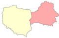
Territorial evolution of Poland

| Territorial evolution of Poland in the 20th century |
|---|
From a nucleus between the
Territorial history
In 1492, the territory of Poland-Lithuania – not counting the fiefs of Mazovia, Moldavia, and East Prussia – covered 1,115,000 km2 (431,000 sq mi), making it the largest territory in Europe; by 1793, it had fallen to 215,000 km2 (83,000 sq mi), the same size as Great Britain, and in 1795, it disappeared completely.[4] The first 20th-century incarnation of Poland, the Second Polish Republic, occupied 389,720 km2 (150,470 sq mi), while, since 1945, a more westerly Poland covered 312,677 km2 (120,725 sq mi).[5]
The Poles are the most numerous of the

The Polish–Lithuanian Commonwealth had many characteristics that made it unique among states of that era. The Commonwealth's
In the late 18th century, the Polish–Lithuanian Commonwealth began to collapse. Its neighbouring states were able to slowly dismember the Commonwealth. In 1795,
During the
Poland currently has a population of over 38 million people,
Territorial timeline
In
Beginning with the Lithuanian Grand Duke
Duchy of Prussia
In 1525, during the
Duchy of Courland and Semigallia
The
Kingdom of Poland until 1385
Territorial changes before and during the
992

1025

During the reign of
1050
The first Piast monarchy collapsed after the death of Bolesław's son – king
After returning from exile in 1039,
1125

After a power struggle,
At this time, Christianization of the region was initiated in earnest, an effort crowned by the establishment of the Pomeranian Wolin Diocese after Bolesław's death in 1140.[30]
1145
The Testament of Bolesław III Krzywousty was a political act by the
1238
.JPG)
In the first half of the 13th century Silesian duke
1248
Few years after the death of
1295

In 1295, Przemysł II of Greater Poland became the first, since Bolesław II, Piast duke crowned as King of Poland, but he ruled over only a part of the territory of Poland (including from 1294 Gdańsk Pomerania) and was assassinated soon after his coronation.
1300
A more extensive unification of Polish lands was accomplished by a foreign ruler,
1333–70

After the death of
During this time, all Silesian
In 1329 Władysław I the Elbow-high fought with the
In 1335 John of Bohemia renounced his claim in favour of
King Casimir, being deprived of historically and ethnically Polish lands of Silesia and Pomerelia sought a compensation of this loses in the east. Through a series of military campaigns between 1340 and 1366 Casimir had annexed the
Allied with Denmark and Western Pomerania, Casimir was able to impose some corrections on the western border as well. In 1365
Kingdom of Poland 1385 to 1569
Territorial changes during the
This section is empty. You can help by adding to it. (May 2019) |
Polish–Lithuanian Commonwealth 1569 to 1795
Territorial changes during the Polish–Lithuanian Commonwealth, starting with the Union of Lublin and ending with the Third Partition of Poland.
1610 to 1612
During the
1635

Sweden, weakened by involvement in the Thirty Years' War, agreed to sign the Armistice of Stuhmsdorf (also known as Treaty of Sztumska Wieś or Treaty of Stuhmsdorf) in 1635, favourable to the Polish–Lithuanian Commonwealth in terms of territorial concessions.[41]
1655

In the history of Poland and Lithuania, the Deluge refers to a series of wars in the mid-to-late 17th century that left the Polish–Lithuanian Commonwealth in ruins.[42]

The Deluge refers to the Swedish invasion and occupation of the western half of Poland-Lithuania from 1655 to 1660 and the
1657

The
1660

In the

1667

The
1672

As a result of the

1686

The
1699

The Treaty of Karlowitz, or Treaty of Karlovci, was signed on January 26, 1699, in Sremski Karlovci, a town in modern-day Serbia. The Treaty of Karlowitz was signed following a two-month congress between the Ottoman Empire and the Holy League of 1684, a coalition of various European powers including the Habsburg Monarchy, the Polish–Lithuanian Commonwealth, the Republic of Venice, and the Russia of Peter I Alekseyevich.[49] The treaty concluded the Austro-Ottoman War of 1683–1697, in which the Ottoman side had finally been defeated at the Battle of Senta. The Ottomans ceded most of Hungary, Transylvania, and Slavonia to Austria while Podolia returned to Poland. Most of Dalmatia passed to Venice, along with the Morea (the Peloponnesus peninsula) and Crete.[48]
1772

In February 1772, an agreement for the partition of the Polish–Lithuanian Commonwealth was signed in Vienna.[50] Early in August Russian, Prussian and Austrian troops simultaneously entered the Commonwealth and occupied the provinces agreed upon among themselves.
By the first partition in 1772, the Polish–Lithuanian Commonwealth lost about 211,000 square kilometres (81,000 sq mi) (30% of its territory, amounting at that time to about 733,000 square kilometres (283,000 sq mi)), with a population of over four to five million people (about a third of its population of 14 million before the partition).[51][52]
1793

By the 1790s the First Polish Republic had deteriorated into such a helpless condition that it was successfully forced into an alliance with its enemy, Prussia. The alliance was cemented with the
Those reforms prompted aggressive actions on the part of Poland's neighbours, wary of a potential renaissance of the Commonwealth. In the second partition, Russia and Prussia took so much territory that only one-third of the 1772 population remained in Poland.[54]
1795

Kosciuszko's insurgent armies, who fought to regain Polish territory, won some initial successes but they eventually fell before the forces of the Russian Empire.[55] The partitioning powers, seeing the increasing unrest in the remaining Commonwealth, decided to solve the problem by erasing any independent Polish state from the map. On 24 October 1795 their representatives signed a treaty dividing the remaining territories of the Commonwealth between their three countries.[56]
Partitioned Poland 1795 to 1918
Territorial changes during the time after the Partitions, starting with the Third Partition of Poland and ending with the creation of the Second Polish Republic.
1807
Duchy of Warsaw

The Duchy of Warsaw was a Polish state established by Napoleon in 1807 from the Polish lands ceded by the Kingdom of Prussia under the terms of the Treaties of Tilsit. The duchy was held in personal union by one of Napoleon's allies, King Frederick Augustus I of Saxony.[57]
Free City of Danzig (Napoleonic)
Prussia had acquired the City of Danzig in the course of the
1809

In 1809, a short war with Austria started. Although the Duchy of Warsaw won the Battle of Raszyn, Austrian troops entered Warsaw, but Duchy and French forces then outflanked their enemy and captured Kraków, Lwów and much of the areas annexed by Austria in the Partitions of Poland. After the Battle of Wagram, the ensuing Treaty of Schönbrunn allowed for a significant expansion of the Duchy's territory southwards with the regaining of once-Polish and Lithuanian lands.
1815

Following Napoleon's failed invasion of Russia, the duchy was occupied by Prussian and Russian troops until 1815, when it was formally partitioned between the two countries at the Congress of Vienna.[58]
Congress Poland
Congress Poland was created out of the Duchy of Warsaw at the Congress of Vienna in 1815, when European states reorganized Europe following the Napoleonic wars.[59]
Grand Duchy of Posen
The Grand Duchy of Posen was a region in the Kingdom of Prussia in the Polish lands commonly known as "Greater Poland" between the years 1815–1848. According to the Congress of Vienna, it was to have autonomy. In practice, it was subordinated to Prussia and the proclaimed rights for Poles were not respected. The name was unofficially used afterwards for denoting the territory, especially by Poles, and today is used by modern historians to describe different political entities until 1918. Its capital was Posen (Polish: Poznań).[59]
Free City of Cracow
The Free, Independent, and Strictly Neutral City of Cracow with its Territory, more commonly known as either the Free City of Cracow or Republic of Cracow, was a city-state created by the Congress of Vienna in 1815.[60]
1831

After the
1846

In the aftermath of the unsuccessful Kraków uprising, the Free City of Cracow was annexed by the Austrian Empire.[60]
1848

After the defeat of Congress Poland, many Prussian liberals sympathised with the demand for the restoration of the Polish state. In the spring of 1848 the new liberal Prussian government allowed some autonomy to the Grand Duchy of Posen in the hope of contributing to the cause of a new Polish homeland.[62] Due to a number of factors, including the outrage of the German-speaking minority in Posen, the Prussian government reversed course. By April 1848, the Prussian army had already suppressed the Polish militias and National Committees that emerged in March. By the end of the year the Duchy had lost the last vestiges of its formal autonomy, and was downgraded to a Province of the Prussian kingdom.[63]
Second Polish Republic and occupation 1918 to 1945
Territorial changes during the Second Polish Republic and the joint German-Soviet occupation of Poland, starting with the formation of the Republic and ending with the end of the occupation.
1918

The West Ukrainian People's Republic was proclaimed on November 1, 1918, with Lviv (Lwów) as its capital. The Ukrainian Republic claimed sovereignty over Eastern Galicia, including the Carpathians up to the city of Nowy Sącz in the west (despite of Polish majority), as well as Volhynia, Carpathian Ruthenia and Bukovina. Although the majority of the population of the Western-Ukrainian People's Republic were Ukrainians, Poles and Jews, large parts of the claimed territory were considered Polish by the Poles. In Lwów (Lviv) the Ukrainian minority supported the proclamation, the city's significant Jewish minority accepted, remained neutral or had a negative attitude towards the Ukrainian proclamation, and the Polish majority was shocked to find themselves in a proclaimed Ukrainian state.[64] Due to the fact that Poles constituted over 60% of Lviv's inhabitants, almost 30% Jews, and Ukrainians below 10%, the vast majority of the city's inhabitants were against the fact that Lviv belonged to Ukraine and they wanted it to belong to Poland again.
1919
Recreation of Poland

In the aftermath of World War I, the Polish people rose up in the
- Most of the Prussian province of Posen was granted to Poland. This territory had already been taken over by local Polish insurgents during the Great Poland Uprising of 1918–1919.[65]
- 70% of West Prussia was given to Poland to provide free access to the sea, along with a 10% German minority, creating the Polish corridor.[7]
- The east part of Upper Silesia was awarded to Poland after a plebiscite. Sixty percent of residents voted for German citizenship, and 40 percent for Poland; as a result the area was divided.[7]
- To provide a Polish railway line connecting Gdańsk and Warsaw, the area of Działdowo (Soldau) in East Prussia was granted to the new Polish state.[66]
- From the eastern part of West Prussia and the southern part of East Prussia in the provinces of Warmia and Masuria, a small area was granted to Poland.[67]
Poland seizes West Ukrainian People's Republic

On July 17, 1919, a ceasefire was signed in the Polish–Ukrainian War with the West Ukrainian People's Republic (ZUNR). As part of the agreement Poland kept ZUNR territory. The West Ukrainian People's Republic then merged with the Ukrainian People's Republic (UNR).[68] On June 25, 1919, Supreme Allies Council transferred East Galicia (ZUNR territory) to Poland.[67]
Polish–Soviet War
The Polish–Soviet War (February 1919 – March 1921) was an armed conflict between Soviet Russia and Soviet Ukraine on the one hand and the Second Polish Republic and the short-lived Ukrainian People's Republic on the other. The war was the result of conflicting expansionist ambitions. Poland, whose statehood had just been re-established by the Treaty of Versailles following the Partitions of Poland in the late 18th century, sought to secure territories it had lost at the time of the partitions. The aim of the Soviet states was to control those same territories, which the Russian Empire had gained in the partitions of Poland.[69]
-
 March 1919
 -
 December 1919
 -
 June 1920
 -
 August 1920
 -
 Treaty of Riga


1920
Free City of Danzig
The
Poland was given full rights to develop and maintain transportation, communication, and port facilities in the city.[73] The Free City was created in order to give Poland access to a good-sized seaport.

Polish–Lithuanian War
The Polish–Lithuanian War was an armed conflict between Lithuania and the Second Polish Republic, lasting from August 1920 to October 7, 1920, in the aftermath of World War I, not long after both countries had regained their independence. It was part of a wider conflict over disputed territorial control of the cities of Vilnius (Polish: Wilno), Suwałki (Lithuanian: Suvalkai) and Augustów (Lithuanian
In the aftermath of the war the Republic of Central Lithuania was created in 1920 following the staged rebellion of soldiers of the 1st Lithuanian-Belarusian Infantry Division of the Polish Army, supported by the Polish air force, cavalry and artillery.[74] Centered on the historical capital of the Grand Duchy of Lithuania, Vilna (Lithuanian: Vilnius, Polish: Wilno), for eighteen months the entity served as a buffer state between Poland, upon which it depended, and Lithuania, which claimed the area.[75]
Negotiations with Russia

Soon after the
Negotiations with Czechoslovakia

During the closing years of
- The Duchy of Cieszyn
The Cieszyn Silesia or the Duchy of Cieszyn (German: Teschen and Czech: Tesin) was a small area that the pre-World War I census showed was predominantly Polish in three districts (Teschen, Bielsko and Frysztat) and mainly Czech in the fourth district of Frydek. The economic importance of Cieszyn Silesia lay in the rich coal basin around Karvina and in the valuable Košice–Bohumín Railway, which linked Bohemia with Slovakia. In northern Cieszyn Silesia, the railroad junction of Bohumín (German: Oderberg and Czech: Bohumin) served as a crossroads for international transport and communications.[78]
Claims over these regions turned violent in 1919 with a brief military conflict, the Seven-day war, between Polish and Czechoslovak units. The Allied governments pressed for a ceasefire and on 3 February 1919 a Polish–Czech border agreement was signed on the basis of the 5 November 1918 ethnic division agreement.[67] This was later changed at the Conference of Ambassadors in Spa, Belgium on 28 July 1920. Cieszyn (German: Teschen) was divided along the Olza river between the two newly created states of Poland and Czechoslovakia. The smaller western suburbs of Cieszyn were joined to Czechoslovakia as the new town of Český Těšín along with the railroad and the Karvina coal basin.[79][78] Poland received the portion of Cieszyn east of the Olza river.[78] The Conference of Ambassadors divided the region just as the Red Army was nearing Warsaw.[80]
- Orawa and Spisz
The county of Orawa (Slovak: Orava) arose before the 15th century. The county's territory is situated along the Orava River between Zazriva and the Tatra Mountains. Spisz (Slovak: Spiš) is situated between the High Tatras and the Dunajec River in the north, the springs of the Váh River in the west, the Slovak Ore Mountains and the Hnilec River in the south, and a line running from the town of Stara Ľubovňa, via the Branisko Mountains, to the town of Margecany in the east. While the Orawa and Spisz border was in arbitration, many groups fought to be a part of Poland, including a number of Polish authors. They began to write about an alleged three hundred thousand Poles living in the Orawa territory.[81]
The Conference of Ambassadors decided that Czechoslovakia would cede to Poland a number of villages from the Orawa and Spisz regions, including the municipalities of Oravy Srnie, Podvlk, Harkabúz, Nižná Zubrica, Vyšná Zubrica, Oravka, Bukovina-Podsklie, Pekelník, Jablonka, Chyžné, Hladovka, Suchá Hora, Vyšná Lipnica, a part of Nižné Lipnice and 4.2% of the rather Belá new communities, with Fridman (Falštin settlement), Krempach, Tribš, Durštín, Čierna Hora, Jurgov, Repiská, Vyšné lapse, Nižné lapse, Nedeca, Kacvín and Lapšanka.[82]
1921
In late 1921 a border adjustment between the
The plebiscite took place on March 20, 1921, two days after the signing of the
1922

After a variety of delays, a disputed election to join Poland took place on January 8, 1922, and the Republic of Central Lithuania became part of Poland,[84] finalizing the geography of Poland's eastern Kresy region until the Invasion of Poland in 1939.
1924

The
1938

As Czechoslovakia was being

Poland seized land from northern Spisz and northern Orawa, including territories around Suchá Hora and Hladovka, around Javorina, around Leśnica in the Pieniny Mountains, a small territory around Skalité, and some other very small border regions. They officially received the territories on 1 November 1938. Polish military groups began to carry out assimilation of the population. Polish was introduced as the only official language and the Slovak Intelligence were displaced from the territories.[88]
1939

World War II
In 1939, Germany and the Soviet Union invaded Poland and partitioned it pursuant to the Molotov–Ribbentrop Pact.[89]
After the invasion, Germany annexed the lands it lost to reformed Poland in 1919–1922 by the Treaty of Versailles: the Polish Corridor, West Prussia, the Province of Posen, and parts of eastern Upper Silesia. The council of the Free City of Danzig voted to become a part of Germany again, although Poles and Jews were deprived of their voting rights and all non-Nazi political parties were banned. Parts of Poland that had not been part of Wilhelmine Germany were also incorporated into the Reich.
Two decrees by Adolf Hitler (October 8 and October 12, 1939) provided for the division of the annexed areas of Poland into the following administrative units:
- Warszawa Voivodeship;
- Reichsgau Danzig-West Prussia (initially Reichsgau West Prussia), which consisted of the remaining area of the Pomeranian Voivodeship and the Free City of Danzig;
- ), which became a part of East Prussia;
- Katowice District (Regierungsbezirk Kattowitz), or unofficially East Upper Silesia (Ost-Oberschlesien), which included Sosnowiec, Będzin, Chrzanów, and Zawiercie Counties, and parts of Olkusz and Żywiec Counties.

These territories had an area of 94,000 square kilometres (36,000 sq mi) and a population of 10,000,000 people. The remaining Polish territory was annexed by the Soviet Union or made into the German-controlled
After the
Communist and modern Poland since 1945
Territorial changes during the Polish People's Republic and modern Third Polish Republic, since the end of World War II.
1945
At the end of World War II, the Allies formally accepted the unconditional surrender of Nazi Germany. There were extensive changes to the territorial extent of Poland, following the decision taken at the Tehran Conference of 1943 at the insistence of the Soviet Union. The Polish territories east of the Curzon Line (known as the Kresy), which the Soviet Union had occupied in 1939 along with the Bialystok region were permanently annexed, resulting in Poland losing over 20% of its pre-war borders.[90] While a large portion of this area was predominately populated by Ukrainians and Belarusians, most of their Polish inhabitants were expelled.[91] Today these territories are part of Belarus, Ukraine and Lithuania.
Poland received
-
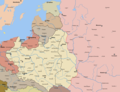
 USSR and Nazi Germany carve up Poland in 1939 approximately along the Curzon Line
 -
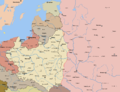
 Poland's borders after World War II. Blue line: Curzon Line of 8 December 1919. Pink areas: Parts of Germany in 1937 borders. Grey area: Territory annexed by Poland between 1919 and 1923 and held until 1939, which after World War II was annexed by the Soviet Union.
 -
 Planned and actual divisions of Europe, according to the Molotov–Ribbentrop Pact, with later adjustments
 -
 Molotov–Ribbentrop Pact showing the new German-Soviet border Sept 28 1939
 -
 Historical Western Borders of Poland. Polish poster from interwar period


Polish-Soviet border changes

On August 16, 1945, a
As a result, Poland lost about 178,000 square kilometres (69,000 square miles) of its pre-war territory in the east, but gained some 101,000 square kilometres (39,000 square miles) in the west and north.[94]
-
 Byelorussian SSR before adjustment
 -
 Byelorussian SSR after adjustment


Czechoslovakia
After the Second World War the Czechoslovak government wanted to return to the 1920 border between the two nations, while Polish inhabitants of Trans-Olza were in favour of the boundary of August 31, 1939. On May 20, 1945, in Trstena an agreement for a return to the 1938 borders of Poland was signed and the following day the Czechoslovak border guards moved to the old Czechoslovak border. At several places there were fights between Polish and Czechoslovak militias, but the situation calmed with the arrival of Polish troops on July 17, 1945.[95] The Polish government still did not want to give up Trans-Olza, and on June 16, 1945, Marshall Michał Rola-Żymierski issued directive number 00336, which ordered the 1st Armoured Corps of the Polish Army to concentrate in the area of Prudnik, Rybnik and Cieszyn, and to seize Trans-Olza.[96][97] However, the Soviets decided to hand the region to Czechoslovakia, and the Poles followed the Moscow directive. The Czechs demanded former German areas of Klodzko, Glubczyce, and Racibórz, but after Soviet mediation, all sides signed a treaty on September 21, 1945, which accepted the December 31, 1937, Polish – Czechoslovak and Czechoslovak – German borderline as the boundary between the two countries.[98]
1948

The Polish border underwent a minor correction in 1948, when the village of Medyka near Przemyśl was transferred to Poland.[99]
1949
In 1949, there was modest exchange of territory between the Polish People's Republic and the German Democratic Republic (GDR). What is now the B 104/B 113 road junction at Linken, Mecklenburg-Western Pomerania to the immediate west of the Polish town of Lubieszyn was transferred from Poland to the GDR in return for a narrow strip of land lying directly on the west side of the road that connected the settlements of Linki and Buk. This move necessitated the creation of a new road linking Lubieszyn to Linki and Buk that mirrored the new shape of the border.[100]
1951

On February 15, 1951 Aleksander Zawadzki (acting in the name of the President of the Polish Republic) and Andrey Vyshinsky (acting in the name of the Presidium of the Supreme Soviet of the Union of Soviet Socialist Republics) signed Treaty No. 6222. Agreement between the Polish Republic and the Union of Soviet Socialist Republics concerning the exchange of sectors of their state territories. The treaty was a border adjustment, with Poland and the Soviet Union exchanging 480 square kilometres (190 sq mi).[101]
1951
In 1951, a small area of land on Usedom Island (Polish: Uznam) was ceded from the German Democratic Republic (Eastern Germany) to Poland. The water pumping station for Świnoujście (German: Swinemünde) lies on that land and was therefore handed over to Poland. In return, a similarly-sized area north of Mescherin, including the village of Staffelde (Polish: Staw), was transferred from Poland to the German Democratic Republic.[102]
1958
On June 13, 1958, the Agreement concerning the final demarcation of the state frontier between Czechoslovakia and Poland was signed in Warsaw. Adam Rapacki signed for Poland and Václav David signed for Czechoslovakia. The treaty confirmed the border at the line of January 1, 1938, the situation before the Nazi-imposed Munich Agreement transferred territory from Czechoslovakia to Poland.[103]
1968
East Germany and Poland signed a treaty for the Baltic continental shelf delimitation.
1975

In March 1975 Czechoslovakia and Poland modified their border along the Dunajec to permit Poland to construct a dam in the Czorsztyn region, southeast of Krakow.[104]
1989
On May 22, 1989, East Germany and Poland completed the delimitation of their territorial waters in the Gulf of Szczecin.
2002

In 2002, Poland and Slovakia made some further minor border adjustments:
Territory of the Republic of Poland with a total area of 2,969 m2 (31,958.05 sq ft), including:
a) in the area of a viewing tower on the surface of the saddle Dukielskie about 376 m2, according to documents limit referred to in Article 1, paragraph 2
b) on the nameless island with an area of 2,289m², according to documents limit referred to in Article 1, paragraph 3
c) in the Polish village Jaworzynka region with an area of 304 m2, according to documents limit referred to in Article 1, paragraph 4, including real estate, equipment and plants are transferred to the ownership of the Slovak Republic.
Territory of the Slovak Republic with an area of 2,969 m2, including:a) in the area of a viewing tower on Dukielskie enters an area of 376 m2, according to documents limit referred to in Article 1, paragraph 2
b) Nokiel on the island with an area of 2,289 m2, according to documents limit referred to in Article 1, paragraph 3
c) in the Slovak village Skalité region with an area of 304 m2, according to documents limit referred to in Article 1, paragraph 4, including real estate, equipment and plants are transferred to the ownership of the Republic of Poland.
— Dziennik Ustaw z 2005 r. Nr 203 poz. 1686, .[105]
See also
- Polish–Czechoslovak border conflicts
- Polish historical regions
- Borders of Poland
- Geography of Poland
- Treaty of Warsaw (1970)
References
Footnotes
- ^ UN Statistics Archived 2009-12-22 at the Wayback Machine
- ^ CIA Factbook
- ^ Central Statistical Office (Poland). 28 July 2008. Retrieved 2008-08-12.
- ^ a b Davies, Norman (2005). God's Playground. A History of Poland. Volume I: The Origins to 1795. Oxford: Oxford University Press. p. 23.
- ^ Davies, Norman (2005). God's Playground. A History of Poland. Volume I: The Origins to 1795. Oxford: Oxford University Press. p. 24.
- ISBN 0-7230-0624-5.
- ^ ISBN 0-8369-0050-2.
- ^ "Poland". Encyclopædia Britannica. 2009. Retrieved May 23, 2009.
Established as a kingdom in 922 under Mieszko I, Poland was united with Lithuania in 1386 under the Jagiellon dynasty (1386–1572) to become the dominant power in east-central Europe, enjoying a prosperous golden age.
- ^ "Heritage: Interactive Atlas: Polish–Lithuanian Commonwealth". PBS. 2009. Retrieved May 23, 2009.
At its apogee, the Polish–Lithuanian Commonwealth comprised some 400,000 square miles (1,000,000 km2) and a multi-ethnic population of 11 million.
- ISBN 0-06-097468-0.
Poland-Lithuania was another country that experienced its 'Golden Age' during the sixteenth and early seventeenth centuries. The realm of the last Jagiellons was absolutely the largest state in Europe. - ISBN 1-877864-30-7.
"the deluge," denoting the downfall of Poland, at that time the largest state in Europe, stretching from the Baltic to the Black Sea and from the Oder to the Dnieper River. - ISBN 963-9241-18-0.
- ISBN 0-19-820654-2.
enabled them to push a new constitution through the Diet, transforming Poland from an anarchic republic ... into a reasonably modern constitutional monarchy - ISBN 0-8223-1802-4.It was Poland more than any other Western European country that became the early symbol of a liberal and constitutional monarchy.
- ^ "Lublin, Union of". Encyclopædia Britannica. 2009. Retrieved May 23, 2009.
Formally, Poland and Lithuania were to be distinct, equal components of the federation… But Poland, which retained possession of the Lithuanian lands it had seized, had greater representation in the Diet and became the dominant partner.
- ISBN 90-420-1016-9.Quoting from Sarmatian Reviewacademic journal mission statement: Polish–Lithuanian Commonwealth was […] characterized by religious tolerance unusual in pre-modern Europe
- ISBN 0-313-30932-9.[Poland] secured for a time a rule of religious tolerance, particularly in the sixteenth and seventeenth centuries ... The situation changed, however, toward the end of the seventeenth and eighteenth centuries.
- ^ NationMaster.com 2003–2007, Poland, Facts and figures
- ^ "Past and Present Regions of Poland". University at Buffalo, The State University of New York. 2009. Retrieved May 23, 2009.
- ISBN 978-0-521-85332-3. Retrieved 5 April 2012.
- ^ Andrzej Buko, "Archeologia Polski wczesnośredniowiecznej", 2007, Ed. Trio.
- ^ Thietmari chronicon, vol. I p. 33; argument presented by G. Labuda, Mieszko I, p. 171.
- ISBN 963-04-2913-6.
- ISBN 83-08-02855-1.
- ISBN 83-01-03732-6, pp. 88–93
- ^ Various authors, ed. Marek Derwich and Adam Żurek, U źródeł Polski (do roku 1038) (Foundations of Poland (until year 1038)), p. 168–183, Andrzej Pleszczyński
- ISBN 83-01-03732-6, pp. 93–96
- ^ Various authors, ed. Marek Derwich and Adam Żurek, U źródeł Polski (do roku 1038) (Foundations of Poland (until year 1038)), pp. 182–187, Andrzej Pleszczyński
- ISBN 83-7000-016-9, PPWK Warszawa–Wrocław 1998, p. 5
- ^ ISBN 83-01-03732-6, pp. 101–104
- ^ Norman Davies, God's Playground, pages: xxvii
- ^ Norman Davies, God's Playground, page: 60
- ISBN 3-486-56615-6.
- ^ Zientara 2002, pp. 317–320.
- ^ Wiktor Fenrych, Nowa Marchia w dziejach politycznych Polski w XIII i w XIV wiekuPoznań 1959, p. 5
- ISBN 83-01-03732-6, pp. 129–141, 154–155
- ISBN 978-83-932012-1-1
- ^ Encyclopædia Britannica: Silesia
- ISBN 83-240-0172-7.)
{{cite book}}: CS1 maint: location missing publisher (link - ISBN 83-01-03732-6, pp. 160–171
- ISBN 978-83-242-0873-9. 9788324208739.
- ^ a b c "The Deluge, 1648–67". USA.gov. 2009. Retrieved May 22, 2009.
- ^ "Treaty of Wehlau". Encyclopædia Britannica. 2009. Retrieved May 23, 2009.
(Sept. 19, 1657), agreement in which John Casimir, king of Poland from 1648 to 1668, renounced the suzerainty of the Polish crown over ducal Prussia and made Frederick William, who was the duke of Prussia as well as the elector of Brandenburg (1640–88), the duchy's sovereign ruler.
- ^ Peace of Oliva. 2009. Archived from the original on April 28, 2009. Retrieved May 23, 2009.
{{cite encyclopedia}}:|work=ignored (help) - ^ a b Rickard, J (July 26, 2007). "Truce of Andrusovo". historyofwar.org. Retrieved May 23, 2009.
- ^ Dariusz Kolodziejczyk (2009). "The Ottoman Survey Register of Podolia (ca. 1681)". Harvard University. Retrieved May 23, 2009.
- ^ "Polish–Ottoman War, 1672–1676". zum.de. November 19, 2004. Retrieved May 23, 2009.
- ^ a b "Eternal Peace of 1686". Encyclopedia of Ukraine. 2009. Retrieved May 23, 2009.
- ISBN 0-415-16111-8.
- ^ "Catherine the Great (1729–1796)". BBC News. 2009. Retrieved May 23, 2009.
- ^ Poland, Partitions of. (2008). Encyclopædia Britannica. Retrieved April 28, 2008, from Encyclopædia Britannica Online: http://www.britannica.com/eb/article-9060581
- ISBN 0-521-55917-0.
- ISBN 0-415-25490-6.pg 128 – The result was the March 1790 Polish–Prussian alliance ... Warsaw's viewpoint the alliance made sense, but the sejm's refusal to pay Prussia's price for it ... made it of problematic value.
- ISBN 0-521-55917-0.- the Prussians and the Russians signed a second treaty of Partition in St Petersburg on 23 January 1793. Catherine would take a slab of land ... William would acquire a triangle of territory between Silesia and East Prussia.
- ISBN 83-85576-10-X.
- ^ "The Three Partitions, 1764–95". USA.gov. 2009. Retrieved May 23, 2009.
- ^ a b "Constitution of the Duchy of Warsaw". poland.pl. 2009. Archived from the original on September 27, 2007. Retrieved May 23, 2009.
- ^ Bloy, Marjie (April 30, 2002). "The Congress of Vienna, 1 November 1814 — 8 June 1815". victorianweb.org. Retrieved May 23, 2009.
- ^ ISBN 978-0-8204-7866-1.
- ^ ISBN 0-8063-1378-1.
- ISBN 0-415-23110-8.
- ISBN 0-7190-3800-6.
Many Prussian liberals sympathised with the demand for the restoration of the Polish state. Since the defeat of the uprising of the 1830–31 in Congress Poland ... In the spring of 1848 the new liberal Prussian government allowed some autonomy to Posen in the hope of contributing to the cause of restoration. - ISBN 0-415-16111-8.
April 1848 ... the Prussian army had already suppressed the [Grand Duchy of Posen] Polish militias and National Committee which had emerged in March. After 1848 [Grand Duchy of Posen] lost the last vestiges of its formal autonomy, and was downgraded to a mere Provinz of the Prussian kingdom... - ISBN 0-8020-8390-0.
- ISBN 0-313-26007-9.
- ^ "Działdowo Years 1871–1920". The City Działdowo. 2006. Retrieved May 23, 2009.
Zasadniczym i podstawowym powodem powyższej decyzji zapisanej w artykule 28 traktatu była konieczność włączenia do Polski obszaru linii kolejowej łączącej Gdańsk z Warszawą. – Translation – The primary and fundamental reason for this decision, enshrined in article 28 of the Treaty, was the need to integrate the Polish area of the railway line connecting Gdańsk and Warsaw.
- ^ ISBN 0-87052-282-5.; demands that the Western Allies incorporate into Poland all of the lands annexed by Prussia in the partitions.
Dec3-5, 1918 Provincial Seym in Poznań of 1403 deputies from Gdańsk-Pomerania, Warmia, Mazuria, Silesia, Poznania, and German areas populated by Poles; appointing a Supreme People's Council
Feb. 3, 1919 Signing in Paris of Polish–Czech border agreement on the basis o Nov. 5, 1918, ethnic division agreement.
June 25, 1919, Supreme Allies Council transferring East Galicia to Poland... July 11, 1920, British anti-Polish decisions in the plebiscite in East Prussia (Powisle, Warmia, and Mazuria) during Soviet offensive towards Warsaw...
July 28, 1920, Allied ambassadors decision partitioning Cieszyn, Silesia, and leaving in Czechoslovakia a quarter of a million Poles in the strategic Moravian Gate...(leading to Poland from south-west) - ^ "Ukraine after the Russian Revolution". Government of Ukraine. mfa.gov.ua. 2009. Retrieved May 23, 2009.
A Western Ukrainian People's Republic was also declared in Lviv on October 19, 1918. The ZUNR formally (and largely symbolically) joined the UNR
- ISBN 0-312-29398-4.
- ISBN 978-3-406-60587-1.
- ISBN 3-8258-6284-4.
- ISBN 978-0-203-84847-0.
- The Avalon Project. Archived from the originalon February 14, 2008. Retrieved May 3, 2007.
- ISBN 5-89957-012-1.
- ISBN 0-903983-00-1.
- ^ "Wojna polsko-bolszewicka" (in Polish). Internetowa encyklopedia PWN. 2009. Archived from the original on November 11, 2013. Retrieved May 23, 2009.
- ISBN 0-300-07662-2.
- ^ ISBN 0-8166-5886-2.: Oderberg) served as a crossroad for international transport and communications.
Duchy of Cieszyn (German: Teschen and Czech: Tesin) was a small area ... on the eve of the First World War its population was predominantly Polish in three districts (Teschen, Bielsko and Frysztat) and mainly Czech in the fourth district of Frydek. The chief importance of Teschen lay in the rich coal basin around Karvina and in the ... valuable Bohumin-Kosice railroad, which linked Bohemia with Slovakia ... Furthermore the railroad junction of Bogumin (Czech: Bohumín, German
p. 158 – According to it Teschen was divided along the Olza River, which left the railroad and the Karvina coal basin to Czechoslovakia ... - ISBN 0-415-93921-6.
Cieszyn – City on the border of Poland and Czechoslovakia , subject of a Polish–Czech conflict in 1919. The conflict was resolved by a decision of the Conference of Ambassadors (28 July 1920), which divided the city into a Polish part (Cieszyn) and a Czech part (Tesin). A treaty between Poland and Czechoslovakia on the community of Cieszyn was signed on 21 December 1920. The entire town was within the borders of Poland from 11 October 1938 to 1 September 1939 as a result of the Munich Agreement in 1938. After World War II the division of Cieszyn as of 1920 was restored. - ISBN 0-7146-4995-3.
- ISBN 80-85491-43-5.
- ISBN 80-85491-43-5.
- ^ a b c d Anna M. Cienciala (Fall 2007). "The rebirth of Poland". web.ku.edu. Retrieved May 23, 2009.
- ISBN 9955-584-87-4.
- ISBN 0-415-93922-4.
Javorzyna – The dispute was submitted to the Permanent Court of International Justice. On the basis of the court's decision, the League of Nations Council, on 12 March 1924, delimited the border, leaving Javorzyna within Czechoslovakia; this was recognized by both sides in a protocol signed on 6 May 1924 in Kraków and approved by the Conference of Ambassadors on 5 September 1924 - ISBN 83-89188-59-7.
- ISBN 0-7818-0673-9.
- ISBN 80-85491-43-5.
- ISBN 0-472-10806-9.
- ISBN 978-0-7425-5542-6.
- ISBN 966-7060-15-2.
- ^ ISBN 3-525-35790-7."
"From June until mid-July, Polish military and militia expelled nearly all of the residents of the districts immediately east of the rivers Oder-Neisse line"
"From June until mid July, Polish military and militia expelled nearly all people from the districts immediately east of the rivers Oder–Neisse line - ^
 Poland and the USSR: Umowa graniczna pomiędzy Polską a ZSRR z 16 sierpnia 1945 roku on Wikisource
- ^ John B. Allcock. Border and territorial disputes. Longman Current Affairs. 1992. p. 148.
- ISBN 80-85491-43-5.
- ^ Andrzej Garlicki; Skrawek Ziemi (2009). "Scrap of land". slaskiesprawy. Retrieved May 23, 2009.
- ^ Nowik, Mariusz (2015-06-10). "Rocznica dziwnej wojny: 70 lat temu czeskie wojska weszły do Polski". www.polityka.pl (in Polish). Retrieved 2022-06-09.
- ISBN 83-87251-71-2.
- ISBN 978-83-89188-66-3.
warto dodac, ze w 1948 r. prezeprowadzono inna, mniej znana regulacje granicy, dzieki ktorej w polsce znalazla sie medyka, pierwotnie pozostawiona po stronie radzieckiej, oraz kilka wsi no pogorzu przemyskim – translation – In addition in 1948 there was a less well-known border adjustment, medyka and a few villages, which were originally left on the Soviet side. - ISBN 83-7241-272-3(in Polish).
- ^ "Treaty No. 6222. Agreement between the Polish Republic and the Union of Soviet Socialist Republics concerning the exchange of sectors of their state territories" (PDF). United Nations. 2009. Archived from the original (PDF) on May 19, 2011. Retrieved May 23, 2009.
- ^ "Marking of borders/Oznakowanie granic". Museum of Polish Border Formation/Muzeum Polskich Formacji Granicznych. 2020. Retrieved April 21, 2020.
- ^ "No 5064 – Agreement concerning the final demarcation of the state frontier" (PDF). United Nations. June 13, 1958. Retrieved May 23, 2009.
- ^ "Dunajec". Columbia Encyclopedia (Sixth ed.). 2008. Retrieved May 23, 2009.
- ^ "Official text of the treaty" (Rich Text Format). Retrieved July 16, 2009. Dziennik Ustaw z 2005 r. Nr 203 poz. 1686 (in Polish)
Bibliography
- Davies, Norman (2005). God's Playground. A History of Poland. Volume I: The Origins to 1795. Oxford: Oxford University Press. p. 23.
- Grzegorz Rąkowski (2007). Ziemia lwowska (in Polish). Opublikowana przez Oficyna Wydawnicza "Rewasz". p. 577. ISBN 978-83-89188-66-3.
External links
| By country | |
|---|---|
| By former country | |
| By subdivision |
|
| By region |
|
| By country, people, region or period | |
| By international organisation | |