
Beit She'an
Beit She'an
בֵּית שְׁאָן | |
|---|---|
| Hebrew transcription(s) | |
| • ISO 259 | Beit Šˀan |
| • Translit. | Bet Šəʼan |
| • Also spelled | Bet She'an (official) Beth Shean (unofficial) |
 Beit She'an | |
 | |
 Beit She'an  Beit She'an | |
| Coordinates: 32°30′N 35°30′E / 32.500°N 35.500°E | |
| Country | |
| District | Northern |
| Founded | 6th–5th millennia BCE (Earliest settlement) Bronze Age (Canaanite town) |
| Government | |
| • Mayor | Jackie Levy |
| Area | |
| • Total | 7,330 dunams (7.33 km2 or 2.83 sq mi) |
| Population (2022)[1] | |
| • Total | 19,073 |
| • Density | 2,600/km2 (6,700/sq mi) |
| Name meaning | House of Tranquillity[2] |
| Website | http://www.bet-shean.org.il |
._Beisan_mound_LOC_matpc.17062.jpg)
Beit She'an (
Beit She'an is believed to be one of the oldest cities in the region. It has played an important role in history due to its geographical location at the junction of the Jordan River Valley and the Jezreel Valley. Beth She'an's ancient tell contains remains beginning in the Chalcolithic period. When Canaan came under Imperial Egyptian rule in the Late Bronze Age, Beth She'an served as a major Egyptian administrative center.[3]
During the Hellenistic period, the settlement was known as Scythopolis (Ancient Greek: Σκυθόπολις). After the region came under Roman rule, Scythopolis gained imperial free status and was the leading city of the Decapolis. A multi-cultural metropolis under Byzantine rule, it served as the capital of the province of Palaestina Secunda, and had a mixed population of Christians, pagans, Jews and Samaritans. After the Arab conquest of the Levant, and following a series of devastating earthquakes (most notably in 749), the city lost its prominence, and became a medium-sized country town.[3][4]
The population of the town was completely changed from 1948 to 1950. It had been entirely Muslim and Christian, designated to be part of the Jewish state in the 1947 United Nations Partition Plan for Palestine, and was captured by the Haganah in May 1948. The battle over the town during Operation Gideon caused most of its inhabitants to flee, and the remainder were expelled.[5] The town was then resettled by Jewish immigrants.[5] Today, Beit She'an serves as a regional centre for the towns in the Beit She'an Valley. The ancient city ruins are now protected within the Beit She'an National Park. The town is located near the Jordan River Crossing, one of three crossing points between Israel and Jordan.
Geography

Beit She'an's location has always been strategically significant, due to its position at the junction of the Jordan River Valley and the Jezreel Valley, essentially controlling access from Jordan and the inland to the coast, as well as from Jerusalem and Jericho to the Galilee.
Beit She'an is situated on Highway 90, the north–south road which runs the length of the eastern edge of Israel and the West Bank. The city stretches over an area of 7 square kilometers with a substantial national park in the north of the city. Beit She'an has a population of 20,000.[6]
Today the town is under the administration of the Emek HaMa'ayanot Regional Council.
History
Prehistory (Neolithic and Chalcolithic periods)
In 1933, archaeologist G.M. FitzGerald, under the auspices of the
Early Bronze Age

Settlement seems to have resumed at the beginning of the
Middle Bronze Age
A large cemetery on the northern mound was in use from the Bronze Age to
Late Bronze Age
Egyptian period
After the
,_Israel_(25860307202).jpg)
One of the most important finds near the temple is the Lion and Lioness (or a dog[16]) stela, currently in the Israel Museum in Jerusalem, which depicts the two playing.[17]
During the three hundred years of rule by the
Over 50 clay anthropoid coffins were found at the site mainly from the 13th and 12th centuries BC. Most are in the typical Egyptian style but some are of a "grotesque" type linked to the Aegean which caused earlier archaeologists to suggest they were of the "sea peoples" which pharaoh Ramses III claimed to have resettled in the region.[24]
Iron Age

An
The Assyrian conquest of the northern kingdom of Israel under Tiglath-Pileser III (732 BC) brought about the destruction of Beit She'an by fire.[21]
Minimal reoccupation occurred until the Hellenistic period.[21]
Biblical narrative
The
Hellenistic period

The Hellenistic period saw the reoccupation of the site of Beit She'an under the new name "Scythopolis" (Ancient Greek: Σκυθόπολις),[31] meaning "City of the Scythians", possibly named after the Scythian mercenaries who settled there as veterans.[32]
Little is known about the Hellenistic city, but during the 3rd century BCE a large temple was constructed on the tell.
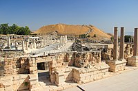
Roman period
In 63 BCE, Pompey made Judea a part of the Roman Republic. Beit She'an was refounded and rebuilt by Gabinius.[35] The town center shifted from the summit of the mound, or tell, to its slopes. Scythopolis prospered and became the leading city of the Decapolis, the only one west of the Jordan River.[36]
The city flourished under the "
-
 The Roman theatre
 -
 Roman cardo
 -
 Roman baths


Byzantine period

Copious archaeological remains were found dating to the
Dedicatory inscriptions indicate a preference for donations to religious buildings, and many colourful mosaics, such as that featuring the zodiac in the Monastery of Lady Mary, or the one picturing a menorah and shalom in the House of Leontius' Jewish synagogue, were preserved. A Samaritan synagogue's mosaic was unique in abstaining from human or animal images, instead utilising floral and geometrical motifs. Elaborate decorations were also found in the settlement's many luxurious villas, and in the 6th century especially, the city reached its maximum size of 40,000 and spread beyond its period city walls.[40]
The Byzantine period portion of the northern cemetery was excavated in 1926. The tombs from this period consisted of small rock-cut halls with vaulted graves on three sides.
Important Christian personalities who lived or passed through Byzantine Scythopolis are St Procopius of Scythopolis (died July 7, 303 AD), Cyril of Scythopolis (ca. 525–559), St Epiphanius of Salamis (c. 310/320 – 403) and Joseph of Tiberias (c. 285 – c. 356) who met there around the year 355.
Early Muslim period
In 634, Byzantine forces were defeated by the
On January 18, 749, Umayyad Baysan was completely devastated by a catastrophic earthquake. A few residential neighborhoods grew up on the ruins, probably established by the survivors, but the city never recovered its magnificence. The city center moved to the southern hill where later the Crusaders built their castle.[45]
Jerusalemite historian
Crusader period

In the
It occasionally passed back under royal control until new lords were created. The town became part of the Belvoir fiefdom.[49]
A small Crusader fortress surrounded by a moat was built in the area southeast of the Roman theatre, where the diminished town had relocated after the 749 earthquake.[45] The fortress was destroyed by Saladin in 1183.[50]
During the 1260 Battle of Ain Jalut, retreating Mongol forces passed in the vicinity but did not enter the town itself.
Mamluk period

Under
Ottoman period

During this period the inhabitants of Beit She'an were mainly Muslim. There were however some Jews. For example, the 14th century
During the 400 years of Ottoman rule, Baysan lost its regional importance. During the reign of Sultan Abdul Hamid II when the Jezreel Valley railway, which was part of the Haifa-Damascus extension of the Hejaz railway was constructed, a limited revival took place. The local peasant population was largely impoverished by the Ottoman feudal land system which leased tracts of land to tenants and collected taxes from them for their use.[2]
The Swiss–German traveler Johann Ludwig Burckhardt described Beisan in 1812: "The present village of Bysan contains seventy or eighty houses; its inhabitants are in a miserable condition, from being exposed to the depredations of the Bedouins of the Ghor, to whom they also pay a heavy tribute."[53]
In 1870/1871 (1288
In the early 20th century, though still a small and obscure village, Beisan was known for its plentiful water supply, fertile soil, and its production of olives, grapes, figs, almonds, apricots, and apples.[2]
British Mandate period


Under the Mandate, the city was the center of the
In 1934,
According to population surveys conducted in
Jewish forces and local Bedouins first clashed during the
Beisan, then an Arab village, fell to the Jewish militias three days before the end of the Mandate.
-
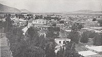 Beisan in 1936
 -
 Beit She’an 1939
 -
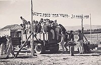 Pioneers ofEin Hanatzivsettle in Bet She'an, 1946


State of Israel
After
From 1969, Beit She'an was a target for Katyusha rockets and mortar attacks from Jordan.[65] In the 1974 Beit She'an attack, militants of the Popular Democratic Front for the Liberation of Palestine, took over an apartment building and murdered a family of four.[56]
In 1999, Beit She'an was incorporated as a city.[66] Geographically, it lies in the middle of the Emek HaMaayanot Regional Council, formerly the Beit She'an Valley Regional Council.[67]
Beit She'an was the hometown and political power base of David Levy, an Israeli politician.
During the Second Intifada, in the 2002 Beit She'an attack, six Israelis were killed and over 30 were injured by two Palestinian militants, who opened fire and threw grenades at a polling station in the center of Bet She'an where party members were voting in the Likud primary.
Archaeology and tourism

The
Earthquakes
Beit She'an is located above the
Demographics
According to the
The age distribution was as follows:
| Age | 0–4 | 5–9 | 10–14 | 15–19 | 20–29 | 30–44 | 45–59 | 60–64 | 65–74 | 75+ |
|---|---|---|---|---|---|---|---|---|---|---|
| Percentage | 9.9 | 9.4 | 9.4 | 9.4 | 17.6 | 17.7 | 16.7 | 2.7 | 4.4 | 2.8 |
| Source: Israel Central Bureau of Statistics[75] | ||||||||||
Economy


Beit She'an is a center of cotton-growing, and many of residents are employed in the cotton fields of the surrounding kibbutzim. Other local industries include a textile mill and clothing factory.[52]
When the ancient city of Beit She'an was opened to the public in the 1990s and turned into a national park, tourism became a major sector of the economy.[76]
Transportation

Beit She'an had a railway station that opened in 1904 on the Jezreel Valley railway which was an extension of the Hejaz railway. This station closed together with the rest of the Jezreel Valley railway in 1948. In 2011–2016 the valley railway was rebuilt and the new Beit She'an railway station, located at the same site as the historical station was opened. Passenger service offered at the station connects the city to Afula, Haifa and destinations in between. In addition to passenger service, the station also includes a freight rail terminal.
Sports
The local football club, Hapoel Beit She'an spent several seasons in the top division in the 1990s, but folded in 2006 after several relegations. Maccabi Beit She'an currently plays in Liga Bet.[citation needed]
Notable people
- Naim Ateek[citation needed]
- Ishtori Haparchi[3]
- David Levy[citation needed]
- Jackie Levy[citation needed]
- Orly Levy, politician (birthplace)[77]
Twin towns – sister cities
Beit She'an is
Historic images
-
 Historic railway station, 1930s
 -
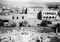 Beit She'an after conquest, 1948
 -
 Ottoman Saray building used by Yiftach Brigade as company barracks, 1948
 -
 Beit Shean ruins
 -
 Lions playing sculpture, roundabout in Beit Shean


See also
References
- ^ a b "Regional Statistics". Israel Central Bureau of Statistics. Retrieved 21 March 2024.
- ^ ISBN 978-1-56656-557-8.
- ^ a b c "Bet Sheʾan | Israel | Britannica". www.britannica.com. Retrieved 2022-06-29.
- ^ אבני, גדעון (2014). "התעצמות ודעיכה: תהליכי שינוי בערי ארץ ישראל בתקופה המוסלמית הקדומה" [Intensification and abatement: processes of change in the cities of Palestine during the early Muslim period]. קתדרה (in Hebrew) (153): 42–43.
- ^ a b Arnon Golan (2002) Jewish Settlement of Former Arab Towns and Their Incorporation into the Israeli Urban System (1948-50), Israel Affairs, 9:1-2, 149-164, DOI: 10.1080/714003467 "The former Arab town of Beisan... Jewish troops took over the town and its environs in fighting in April and May 1948. Most of the Arab population fled at that time, while the handful of remaining residents were expelled following the town's surrender on 13 May, after which it was placed under military government. As early as June 1948 the Israeli authorities initiated a new settlement venture in the Beit Shean valley, which established three new kibbutzim by March 1949. To block any possible return of former Arab residents, the local military government began the demolition of the town's built-up area; this was halted only by the intervention of the Israeli agriculture minister, Aaron Ziesling, who opposed the demolition policy on ideological grounds... The government decided to build 1,000 new apartments in Beisan and to restore 600 former Arab dwelling units for immigrants. In April 1950 the Jewish population of Beisan, renamed in Hebrew "Beit Shean", numbered 2,000, all of them newly arrived immigrants."
- ^ Nefesh B'Nefesh Profiles: Beit She'an
- ^ Braun, Eliot. Early Beth Shean (Strata XIX-XIII): G.M. FitzGerald's Deep Cut on the Tell, p. 28
- ^ a b Braun, p.61-64
- ^ Rowe, Alan. The Topography and History of Beth Shean. Philadelphia: 1930, p. v
- ^ Rowe, p. 2
- ^ No. 110: bt š'ir. Mazar, Amihai. "Tel Beth-Shean: History and Archaeology." In One God, One Cult, One Nation. Ed. R.G. Kratz and H. Spieckermann. New York: 2010, P. 239
- ^ Mazar 242
- ^ Rowe, 10; http://www.rehov.org/project/tel_beth_shean.htm Archived 2012-02-06 at the Wayback Machine
- ^ Rowe 11
- ^ Mazar 247
- ^ a b "Tel Beth Shean: An Account of the Hebrew University Excavations". www.rehov.org. Archived from the original on 2012-02-06.
- ^ Lion and Lioness playing, Israel Museum
- ^ Mazar 250
- ^ Rowe 23–32
- ^ Albright W. The smaller Beth-Shean stele of Sethos I (1309-1290 B. C.), Bulletin of the American schools of Oriental research, feb 1952, p. 24-32.
- ^ a b c "Tel Beth Shean: An Account of the Hebrew University's Excavations". Rehov.org. Archived from the original on 2012-02-06. Retrieved 2012-03-04.
- ^ Mazar 256
- ^ Mazar 253
- ^ Emanuel, Jeffrey P. “‘SEA PEOPLES’ IN EGYPTIAN GARRISONS IN LIGHT OF BETH-SHEAN, (RE-)RECONSIDERED.” Mediterranean Archaeology, vol. 28/29, 2015, pp. 1–22
- ^ "The Beth-Shean Valley Archaeological Project". Rehov.org. Archived from the original on 2012-02-04. Retrieved 2012-03-04.
- ^ Mazar 263
- ISBN 978-3-031-27330-8.
- ^ 1 Samuel 31:10–12
- ^ "Was King Saul Impaled on the Wall of Beth Shean?". The BAS Library. August 31, 2015.
- ^ "Beit She'an, Archaeology in Israel". www.jewishmag.co.il.
- ^ Meyers & Chancey 13
- JSTOR 27924894. Retrieved 2023-04-15.
- ^ Rowe 44
- ^ a b c Rowe 49
- ^ a b Rowe 46
- ^ "Tel Aviv University Institute of Archaeology". en-humanities.tau.ac.il.
- ^ Rowe 53
- ^ Synagogue floor: Beth Shean synagogue, ay IMJ website, accessed 16 July 2019
- ^ a b Rowe 50
- ^ a b Rowe 45
- ^ a b Rowe 52
- ^ "Beit She'an". Jewish Virtual Library.
- ^ A. Walmsley, "Economic Developments and the Nature of Settlement in the Towns and Countryside of Syria-Palestine, ca. 565–800", Dumbarton Oaks Papers 61 (2007), especially pp. 344–45.
- ^ E. Khamis, "Two wall mosaic inscriptions from the Umayyad market place in Bet Shean/Baysan", Bulletin of the School of Oriental and African Studies 64 (2001), pp. 159–76.
- ^ a b "Israel Antiquities Authority, Death of a City". Antiquities.org.il. Archived from the original on 2013-09-15. Retrieved 2012-12-30.
- ^ le Strange, 1890, pp. 18–19.
- ^ le Strange, 1890, p. 30
- ^ le Strange, 1890, p. 411
- ^ גן לאומי בית שאן (in Hebrew). Israel National Parks Authority. Archived from the original on 2012-04-25.
- ISBN 978-0-8264-1316-1.
- ^ Shahin, 2005, p. 164
- ^ a b c "Bet She'an". Encyclopædia Britannica. Retrieved 2008-10-20.
- ISBN 978-1-4142-8338-8.
- ^ Grossman, David (2004). Arab Demography and Early Jewish Settlement in Palestine. Jerusalem: Magnes Press. p. 256.
- ^ Barron, 1923, p. 6
- ^ a b Ashkenazi, Eli (2007-05-11). "The other Beit She'an". Haaretz. Retrieved 2008-10-20.
- ^ "Virtual Israel Experience:Bet She'an". Jewish Virtual Library. Retrieved 2008-10-20.
- ^ Michael B. Oren (Winter 2001). "Orde Wingate: Friend Under Fire". Azure: Ideas for the Jewish Nation. Retrieved 2007-05-15.
- ^ "Settled Population Of Palestine". United Nations. Archived from the original on March 19, 2009. Retrieved 2009-02-01.
- ISBN 978-0-88728-211-9.
- ^ Land Ownership of Palestine—Map prepared by the government of the British Mandate of Palestine on the instructions of the UN Ad Hoc Committee on the Palestine Question (Map). United Nations. Archived from the original on 29 October 2008. Retrieved 2008-10-20.
- JSTOR 2537591.
- ^ WPN Tyler, State lands and rural development in mandatory Palestine, 1920–1948, p. 79
- ISBN 978-88-211-8329-4.
- ^ "Jordanian katusha, bazuka and mortar attack on Beit She'an", Maariv, 22 Jun 1969, scan source: Historical Jewish press
- ^ הסראיה – בית שאן. 7wonders.co.il (in Hebrew). Archived from the original on 5 March 2009. Retrieved 2009-02-08.
- ^ "Beit Shean" (PDF). Friends of the Earth Middle East (FoEME). Archived from the original (PDF) on 26 February 2009. Retrieved 2009-02-04.
- ^ Ousterhout, Robert; Boomer, Megan; Chalmers, Matthew; Fleck, Victoria; Kopta, Joseph R.; Shackelford, James; Vandewalle, Rebecca; Winnik, Arielle. "Beth Shean After Antiquity". Beth Shean After Antiquity.
- ^ "Archaeowiki.org". www.archaeowiki.org. Archived from the original on 16 March 2018. Retrieved 15 March 2018.
- ^ "Beth Shean (Israel)". University of Pennsylvania. Retrieved 2009-02-04.
- ^ Heiser, Lauren (2000-03-10). "Beth Shean" (PDF). Archived from the original (PDF) on 2004-12-28. Retrieved 2009-02-04.
- ^ "Beit She'an". Israel Ministry of Foreign Affairs. Archived from the original on 25 March 2009. Retrieved 2009-02-08.
- JSTOR 27925724– via JSTOR.
- ^ Experts Warn: Major Earthquake Could Hit Israel Any Time By Rachel Avraham, staff writer for United With Israel Date: Oct 22, 2013
- ^ a b "Local Authorities in Israel 2005, Publication #1295 – Municipality Profiles — Beit She'an" (PDF) (in Hebrew). Israel Central Bureau of Statistics. Retrieved 2008-07-05.
- ^ Greenberg, Joel (18 August 1992). "Israeli archaeologists unearthing treasures of a long lost city". The New York Times.
- ^ מפתיעת הסקרים. Mishpacha (in Hebrew). No. 1354. April 26, 2018. p. 24.
- ^ "Cleveland Sister City Partnerships". Encyclopedia of Cleveland History (Case Western Reserve University). Retrieved 2019-05-27.
Bibliography
- Barron, J. B., ed. (1923). Palestine: Report and General Abstracts of the Census of 1922. Government of Palestine.
- Conder, C.R.; Kitchener, H.H. (1882). The Survey of Western Palestine: Memoirs of the Topography, Orography, Hydrography, and Archaeology. Vol. 2. London: Committee of the Palestine Exploration Fund. (Conder and Kitchener, 1882, SWP II, p. 83)
- ISBN 978-0-86054-905-5. (p. 782)
- Department of Statistics (1945). Village Statistics, April, 1945. Government of Palestine. (Department of Statistics, 1945, p. 6)
- Guérin, V. (1874). Description Géographique Historique et Archéologique de la Palestine (in French). Vol. 2: Samarie, pt. 1. Paris: L'Imprimerie Nationale. (284- 298)
- Hadawi, S. (1970). Village Statistics of 1945: A Classification of Land and Area ownership in Palestine. Palestine Liberation Organization Research Centre. (pp. 43, 84134)
- Hütteroth, Wolf-Dieter; Abdulfattah, Kamal (1977). Historical Geography of Palestine, Transjordan and Southern Syria in the Late 16th Century. Erlanger Geographische Arbeiten, Sonderband 5. Erlangen, Germany: Vorstand der Fränkischen Geographischen Gesellschaft. ISBN 978-3-920405-41-4. (p. 168)
- Le Strange, G. (1890). Palestine Under the Moslems: A Description of Syria and the Holy Land from A.D. 650 to 1500. Committee of the Palestine Exploration Fund.
- ISBN 978-0-300-14179-5.
- Mills, E., ed. (1932). Census of Palestine 1931. Population of Villages, Towns and Administrative Areas. Jerusalem: Government of Palestine.
- ISBN 978-0-521-00967-6.
- Shahin, Mariam (2005). Palestine: A Guide. Interlink Books. pp. 159–165. ISBN 978-1-56656-557-8.
- ISBN 978-90-04-11083-0. (see p.195ff)
- Tsafrir, Y. and Foerster, Gideon: "“Nysa-Scythopolis – A New Inscription and the Titles of the City on its Coins", The Israel Numismatic Journal. Vol. 9, 1986–7, pp. 53–58.
- Tsafrir, Y. and Foerster, Gideon: "Bet Shean Excavation Project – 1988/1989", Excavations and Surveys in Israel 1989/1990. Volume 9. Israel Antiquities Authority. Numbers 94–95. Jerusalem 1989/1990, pp. 120–128.
- Tsafrir, Y. and Foerster, Gideon: "From Scythopolis to Baisān: Changes in the perception of the city of Bet Shean during the Byzantine and Arab Eras", Cathedra. For the History of Eretz Israel and its Yishuv, 64. Yad Izhak Ben-Zvi. Jerusalem, July 1992 (in Hebrew).
- Tsafrir, Y. and Foerster, Gideon: "The Dating of the 'Earthquake of the Sabbatical Year of 749 C. E.' in Palestine", Bulletin of the School of Oriental and African Studies of London. Vol. LV, Part 2. London 1992, pp. 231–235.
- Tsafrir, Y. and Foerster, Gideon: "Urbanism at Scythopolis-Bet Shean in the Fourth to Seventh Centuries", Dumbarton Oaks Papers. Dumbarton Oaks Research Library and Collection. Number Fifty-One, 1997. pp. 85–146.
Further reading
- Bet She’an, Hadashot Arkheologiyot – Excavations and Surveys in Israel.
University of Pennsylvania excavations
- Braun, Eliot [2004], Early Beth Shan (Strata XIX-XIII) – G.M. FitzGerald's Deep Cut on the Tell, [University Museum Monograph 121], Philadelphia: University of Pennsylvania Museum, 2004. ISBN 978-1-931707-62-6
- Fisher, C. [1923], Beth-Shan Excavations of the University Museum Expedition, 1921–1923", Museum Journal 14 (1923), pp. 229–231.
- FitzGerald, G .M. [1931], Beth-shan Excavations 1921–23: the Arab and Byzantine Levels, Beth-shan III, University Museum: Philadelphia, 1931.
- FitzGerald, G. M. [1932], "Excavations at Beth-Shan in 1931", PEFQS 63 (1932), pp. 142–145.
- Rowe, A., [1930], The Topography and History of Beth-Shan, Philadelphia: University of Pennsylvania Press, 1930.
- Rowe, A., [1940], The Four Canaanite Temples of Beth-shan, Beth-shan II:1, University Museum: Philadelphia, 1940.
- James, Frances W. & McGovern, Patrick E. [1993], The Late Bronze Egyptian Garrison at Beth Shan: a Study of Levels VII and VIII, 2 volumes, [University Museum Monograph 85], Philadelphia: University Museum, University of Pennsylvania & University of Mississippi, 1993. ISBN 978-0-924171-27-7
Hebrew University Jerusalem excavations
- Mazar, Amihai [2006], Excavations at Tel Beth Shean 1989–1996, Volume I: From the Late Bronze Age IIB to the Medieval Period, Jerusalem: Israel Exploration Society / Hebrew University of Jerusalem, 2006.
- Mazar, A. and Mullins, Robert (eds) [2007], Excavations at Tel Beth Shean 1989–1996, Volume II: The Middle and Late Bronze Age Strata in Area R, Jerusalem: IES / HUJ, 2007.
General
- Finkelstein, I. [1996], "The Stratigraphy and Chronology of Megiddo and Beth-Shan in the 12th–11th Centuries BCE", TA 23 (1996), pp. 170–184.
- Garfinkel, Yosef [1987], "The Early Iron Age Stratigraphy of Beth Shean Reconsidered", IEJ 37 (1987), pp. 224–228.
- Geva, Shulamit [1979], "A Reassessment of the Chronology of Beth Shean Strata V and IV", IEJ 29 (1979), pp. 6–10.
- Greenberg, Raphael [2003], "Early Bronze Age Megiddo and Beth Shean: Discontinuous Settlement in Sociopolitical Context", JMA 16.1 (2003), pp. 17–32.
- Hankey, V. [1966], "Late Mycenaean Pottery at Beth-Shan", AJA 70 (1966), pp. 169–171.
- Higginbotham, C. [1999], "The Statue of Ramses III from Beth Shean", TA 26 (1999), pp. 225–232.
- Horowitz, Wayne [1994], "Trouble in Canaan: A Letter of the el-Amarna Period on a Clay Cylinder from Beth Shean", Qadmoniot 27 (1994), pp. 84–86 (Hebrew).
- Horowitz, Wayne [1996], "An Inscribed Clay Cylinder from Amarna Age Beth Shean", IEJ 46 (1996), pp. 208–218.
- McGovern, Patrick E. [1987], “Silicate Industries of Late Bronze-Early Iron Age Palestine: Technological Interaction between New Kingdom Egypt and the Levant", in Bimson, M. & Freestone, LC. (eds), Early Vitreous Materials, [British Museum Occasional Papers 56], London: British Museum Press, 1987, pp. 91–114.
- McGovern, Patrick E. [1989], "Cross-Cultural Craft Interaction: the Late Bronze Egyptian Garrison at Beth Shan", in McGovern, P.E. (ed,), Cross-Craft and Cultural Interactions in Ceramics, [Ceramics and Civilisation 4, ed. Kingery, W.D.], Westerville: American Ceramic Society, 1989, pp. 147–194.
- McGovern, Patrick E. [1990], "The Ultimate Attire: Jewelry from a Canaanite Temple at Beth Shan", Expedition 32 (1990), pp. 16–23.
- McGovern, Patrick E. [1994], "Were the Sea Peoples at Beth Shan?", in Lemche, N.P. & Müller, M. (eds), Fra dybet: Festskrift until John Strange, [Forum for Bibelsk Eksegese 5], Copenhagen: Museum Tusculanus and University of Copenhagen, 1994, pp. 144–156.
- Khamis, E., "Two wall mosaic inscriptions from the Umayyad market place in Bet Shean/Baysan", Bulletin of the School of Oriental and African Studies 64 (2001), pp. 159–76.
- McGovern, P.E., Fleming, S.J. & Swann, C.P. [1993], "The Late Bronze Egyptian Garrison at Beth Shan: Glass and Faience Production and Importation in the Late New Kingdom", BASOR 290-91 (1993), pp. 1–27.
- Mazar, A., Ziv-Esudri, Adi and Cohen-Weinberger, Anet [2000], "The Early Bronze Age II–III at Tel Beth Shean: Preliminary Observations", in Philip, G. and Baird, D. (eds), Ceramics and Change in the Early Bronze Age of the Southern Levant, [Levantine Archaeology 2], Sheffield: Sheffield Academic Press, 2000, pp. 255–278.
- Mazar, Amihai [1990], "The Excavations at Tel Beth-Shean", Eretz-Israel 21 (1990), pp. 197–211 (יברית).
- Mazar, Amihai [1992], "Temples of the Middle and Late Bronze Ages and the Iron Age", in Kempinski, A. and Reich, R. (eds), The Architecture of Ancient Israel from the Prehistoric to the Persian Periods — in Memory of Immanual (Munya) Dunayevsky, Jerusalem: IES, 1992, pp. 161–187.
- Mazar, Amihai [1993a], "The Excavations at Tel Beth-Shean in 1989–1990", in Biran, A. and Aviram, J. (eds), Biblical Archaeology Today, 1990 – Proceedings of the Second International Congress on Biblical Archaeology, Jerusalem, 1990, Jerusalem: IES, 1993, pp. 606–619.
- Mazar, Amihai [1993b], "Beth Shean in the Iron Age: Preliminary Report and Conclusions of the 1990–1991 Excavations", IEJ 43.4 (1993), pp. 201–229.
- Mazar, Amihai [1994], "Four Thousand Years of History at Tel Beth-Shean", Qadmoniot 27.3–4 (1994), pp. 66–83 (יברית).
- [1997a], "Four Thousand Years of History at Tel Beth-Shean—An Account of the Renewed Excavations", BA 60.2 (1997), pp. 62–76.
- Mazar, Amihai [1997b], "The Excavations at Tel Beth Shean during the Years 1989–94", in Silberman, N.A. and Small, D. (eds), The Archaeology of Israel – Constructing the Past, Interpreting the Present, [JSOT Supplement Series 237], Sheffield: Sheffield Academic Press, 1997, pp. 144–164.
- Mazar, Amihai [2003], "Beth Shean in the Second Millennium BCE: From Canaanite Town to Egyptian Stronghold", in Bietak, M. (ed.), The Synchronisation of Civilisations in the Eastern Mediterranean in the SEcond Millennium BC, II. Proceedings of the SCIEM 2000-EuroConference Haindorf, 2–7 May 2001, Vienna, 2003, pp. 323–339.
- Mazar, Amihai [2006], "Tel Beth-Shean and the Fate of Mounds in the Intermediate Bronze Age", in Gitin, S., Wright, J.E. and Dessel, J.P. (eds), Confronting the Past—Archaeological and Historical Essays on Ancient Israel in Honor of William G. Dever, Winona Lake: Eisenbrauns, 2006, pp. 105–118. ISBN 978-1-57506-117-7
- Mullins, Robert A. [2006], "A Corpus of Eighteenth Dynasty Egyptian-Style Pottery from Tel Beth-Shean", in Maeir, A.M. and Miroschedji, P. de (eds), "I Will Speak the Riddle of Ancient Times"—Archaeological and Historical Studies in Honor of Amihai Mazar on the Occasion of His Sixtieth Birthday, Volume 1, Winona Lake: Eisenbrauns, 2006, pp. 247–262. ISBN 978-1-57506-103-0
- Oren, Eliezer D. [1973], The Northern Cemetery of Beth-Shean, [Museum Monograph of the University Museum of the University of Pennsylvania], E.J. Brill: Leiden, 1973.
- Porter, R.M. [1994–1995], "Dating the Beth Shean Temple Sequence", Journal of the Ancient Chronology Forum 7 (1994–95), pp. 52–69.
- Porter, R.M. [1998], "An Egyptian Temple at Tel Beth Shean and Ramesses IV", in Eyre, C. (ed.), Seventh International Congress of Egyptologists, Cambridge, 3–9 September 1995, [Orientalia Lovaniensia Analecta 82], Uitgeverij Peeters: Leuven, 1998, pp. 903–910.
- Sweeney, Deborah [1998], "The Man on the Folding Chair: An Egyptian Relief from Beth Shean", IEJ 48 (1998), pp. 38–53.
- Thompson, T.O. (1970). Mekal, the God of Beth Shean. Leiden: E.J. Brill. ISBN 978-90-04-02268-3.
- Walmsley, A., 'Economic Developments and the Nature of Settlement in the Towns and Countryside of Syria-Palestine, ca. 565–800', Dumbarton Oaks Papers 61 (2007), pp. 319–52.
External links
- Beit She'an National Park – official site
- BET(H)-SHEAN Jewish Virtual Library
- Ilan Phahima and Yoram Saad, Scythopolis: Conservation of the Roman Bridge, Israel Antiquities Authority Site – Conservation Department
- Survey of Western Palestine, 1880 Map of Beit Shean (Beisân), Map 9: IAA, Wikimedia commons
- Air photo map of Beisan, 1945. Eran Laor Cartographic Collection, The National Library of Israel.
- Map of Beisan, 1929. Survey of Palestine. Eran Laor Cartographic Collection, The National Library of Israel.
.svg)
| Jordan |  | |
|---|---|---|
| Syria |
| |
| Israel | ||
| |||||||||||||||||||
| |||||||||||||||||||
| International | |
|---|---|
| National | |
| Geographic | |
| Other | |