
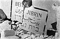
Bayt Jibrin
Bayt Jibrin
بيت جبرين | ||
|---|---|---|
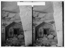
 Historic Bayt Jibrin mansion | ||
.jpg) 1870s map 1870s map .jpg) 1940s map 1940s map.jpg) modern map modern map .jpg) 1940s with modern overlay map 1940s with modern overlay mapA series of historical maps of the area around Bayt Jibrin (click the buttons) | ||
Geopolitical entity Mandatory Palestine | | |
| Subdistrict | Hebron | |
| Date of depopulation | 29 October 1948[3] | |
| Area | ||
| • Total | 56,185 dunams (56.2 km2 or 21.7 sq mi) | |
| Population (1945) | ||
| • Total | 2,430[1][2] | |
| Cause(s) of depopulation | Military assault by Yishuv forces | |
| Current Localities | Beit Guvrin (kibbutz)[4] | |
Bayt Jibrin or Beit Jibrin (
During the 8th century BCE, the nearby village of
The
Name
The town was renamed over the centuries. Its
In the year 200 CE, Roman Emperor Septimius Severus gave it the status of a city under a new Greek name, Eleutheropolis (Ἐλευθερόπολις), meaning 'City of the Free', and its inhabitants were given the rank of Roman citizens under the laws of ius italicum."[15][16][17][18] In the Peutinger Tables in 393 CE, Bayt Jibrin was called Beitogabri. In the Talmud, compiled between the 3rd and 4th centuries, it was known as Beit Gubrin (or Guvrin).[10] To the Crusaders, it was known as Bethgibelin or Gibelin.[19][20] Another name in
History
Iron Age Maresha
The excavations have revealed no remains older than the
Roman and Byzantine periods
In the

Septimius Severus, Roman Emperor from 193 to 211, granted the city municipal status,[29] under a new Greek name, Eleutheropolis, meaning "City of the Free", and giving its citizens the ius italicum and exempting them from taxes.[30][31][32] Coins minted by him, bearing the date 1 January 200, commemorate its founding and the title of polis.[33] Eleutheropolis, which covered an area of 65 hectares (160 acres) (larger at the time than
In the 1st and 2nd centuries CE,
Beit Guvrin is mentioned in the Talmud in the 3rd and 4th centuries, indicating a revival of the Jewish community around that time.[28] The tanna Judah b. Jacob and the amora Jonathan (referred to in the Talmud as "Yonatan me-Bet Guvrin" or Jonathan of Bet Guvrin) were residents of the city. The Talmudic region known as Darom was within the area of Eleutheropolis ("Beit Guvrin"),[42] later known by its Arabic corruption ad-Dārūm.[43] Excavations at Eleutheropolis show a prosperous city, and confirm the presence of Jews and Christians in the area. It was described as one of Palestine's five "Cities of Excellence" by 4th-century Roman historian
Bayt Jibrin is mentioned in the Talmud (redacted 5th–6th century CE) under the name Beit Gubrin. In the Peutinger Tables (393 CE), the place is called Beto Gabra, and shown as 16 Roman miles from Ascalon.[45] The true distance is 20 English miles.[45]
The Midrash Rabba (Genesis Rabba, section 67) mentions Beit Gubrin in relation to Esau and his descendants (Idumaeans) who settled the region, and which region was renowned for its fertile ground and productivity.
Early Islamic period
The 9th-century historian
In 750 Palestine came under
"[Bayt Jibrin] is a city partly in the hill country, partly in the plain. Its territory has the name of Ad Darum (the ancient Daroma and the modern Dairan), and there are here marble [sic] quarries. The district sends its produce to the capital (Ar Ramlah). It is an emporium for the neighbouring country, and a land of riches and plenty, possessing fine domains. The population, however, is now on the decrease...."[51][52]
There is no marble quarry anywhere in Israel/Palestine, but al-Muqaddasi probably referred to the underground
Crusader and Mamluk eras

In 1099,
However, the Crusaders remained in control of Bethgibelin until 1244, when the Ayyubids reconquered it under Sultan
The city prospered under the Egypt-basedOttoman rule and the 'Azza family

Bayt Jibrin and all of Palestine was conquered by the
In the 17th century, Bayt Jibrin may have absorbed residents from Khursa, whose village had been destroyed in an attack by the people of Dura.[59]
In the 19th century, Bayt Jibrin was the

In 1855, the newly appointed Ottoman
In 1838, American archeologist Edward Robinson identified Bayt Jibrin as the site of both ancient Eleutheropolis and ancient Bethgebrim.[65] He cited William of Tyre's reference to the Arabic name.[66] Later travelers who visited Bayt Jibrin during that time were very impressed both by the shaykh of Bayt Jibrin, as well as by his "castle" or "manor". At the time, the remains of the Crusader fortress still served for defensive purposes in the village.[67] According to Bayt Jibrin's shaykh, in 1863, he was in command of 16 villages in the area and pledged "to provide as many as 2,000 men to the government if necessary."[68] In 1864, however, Muslih's brother told a traveler that Muslih and his property had been seized on "false charges of treason," and that he had been banished to Cyprus and then beheaded.[69]
Socin found from an official Ottoman village list from about 1870 that Bayt Jibrin had a population of 508, with a total of 147 houses, though the population count included men, only.[70][71]
Bayt Jibrin's status began to decline throughout the 19th century. According to Western travelers it was "a small and insignificant village". The primary factors that contributed to the decline were the Bedouin raids on Bayt Jibrin's countryside villages, the 'Azza revolt, tribal warfare among the inhabitants of the towns and villages throughout Palestine and epidemics which struck the town and the nearby area.[61]
In 1896 the population of Bet dschibrin was estimated to be about 1,278 persons.[72]
British Mandate era
After the British Army captured Palestine from the Ottomans in 1917–1918,[73]
Bayt Jibrin resumed its role as an important town in the District of Hebron. The population was entirely Muslim, and had two schools, a medical clinic, a bus and a police station. The town's inhabitants cultivated grain and fruit, and residents from nearby towns flocked to its weekly market or
On 10 January 1938, during the Palestinian Arab revolt of 1936-1939, J. L. Starkey, a well-known British archaeologist, was killed by a group of armed Arabs on the track leading from Bayt Jibrin to Hebron.[78]
In the 1945 statistics Bayt Jibrin had 2,430 Muslim inhabitants,[1] with a total of 56,185 dunams of land.[2] Of this, 2,477 dunums were irrigated or used for plantations, 31,616 dunams used for cereals,[79] while 287 dunams were built-up (urban) areas.[5]
Bayt Jibrin was in the territory allotted to the Arab state under the 1947 UN Partition Plan.[80]
1948 war

The First Battalion of the
On October 23, a United Nations-imposed ceasefire went into effect, however, there was an IDF raid on the neighboring police fort on the night of October 24, which resulted in more villagers fleeing Bayt Jibrin.[84] Israeli troops from the
In the 1948 war, the village was attacked by Israeli military units and bombed by Israeli aircraft. By that time, Beit Jibreen already hosted many refugees from neighboring villages. The fighting and bombing frightened the people. They escaped the fighting and sought shelter in the surrounding hills. [My] family found protection in a cave 5 km east of the village. They had left everything in their home, hoping to return after a few days when the attack would be over. The Israelis, however, did not allow them to return. Several men of Beit Jibreen were killed when they tried to go back.[85]
In 1949,
-
 Bayt Jibrin after occupation by Harel Brigade, 1948
 -
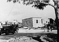
 Building on outskirts of Bayt Jibrin, 1948
 -
 Beit Jibrin police station. 1948
 -
 Beit Guvrin Police station. 1948
 -
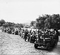 Members of the 89th Battalion outside Beit Gurvin, during Operation Yoav, October 1948


Geography
Bayt Jibrin was situated in an area of plains and soft hills known as the
In 1945, Bayt Jibrin's total land area was 56.1 km2 (21.7 sq mi), 98% of which was Arab-owned. The town's urban area consisted of 287 m2 (0.071 acres), with 33.2 km2 (8,200 acres) of cultivable land and 21.6 km2 (5,300 acres) of non-cultivable land. 54.8% of the town's land was planted with cereal crops, 6.2% with olives and 4.4% with irrigated crops.[2][5]
The Bayt Jibrin region contains a large number of caverns, both natural formations and caves dug in the soft chalk by inhabitants of the region over the centuries for use as quarries, burial grounds, animal shelters, workshops and spaces for raising doves and pigeons. There is estimated to be 800 such caverns,[88] many linked by an underground maze of passageways. Eighty of them, known as the Bell Caves, are located on the grounds of the
Archaeology
Today many of the excavated areas of Maresha and Beit Guvrin can be visited as part of the
In 1838, the American
The largely preserved remains of the amphitheater built by the Romans were excavated by Kloner. Among other unique finds was a Roman bath that has been confirmed to be the largest in Israel and the Palestinian territories.[91] Many of the ancient city's olive presses, columbaria and water cisterns can still be seen. Less than 10 percent of the caves on Tel Maresha have been excavated.[92]
The ruins of three
The wider area of the
Demographics
During the Roman period, Bayt Jibrin had a mixed population of Jews,
In Ottoman tax records from 1596, the town had a population of 275 inhabitants. In the late 19th century its population reached 900, while in 1896 the population was estimated to be about 1,278 persons.[72] In 1912 it was estimated to be about 1,000,[94] and to 1,420 in the next decade.[76] According to the 1931 census of Palestine, Bayt Jibrin's population was 1,804.[77] A 1945 land and population survey by Sami Hadawi reported a sharp increase to 2,430.[2] The general growth pattern over every 9–11 years from 1912 to 1945 was around 400–500. In 1948, the projected population was 2,819.[95]
The number of refugees from Bayt Jibrin, including their descendants, was estimated to be 17,310 in 1998. Many live in the al-'Azza (also called Bayt Jibrin) and Fawwar camps in the southern West Bank.[95]
Culture
Embroidery
Bayt Jibrin, together with Hebron and the surrounding villages, was known for its fine
Also on show is a late 19th-century shambar (large veil) from Bayt Jibrin worn at weddings and festivals. It is made of embroidered handwoven black silk with a separate heavy red silk fringe.[98][99] A woman wore the shambar mainly on her wedding day, positioned so that when she covered her face the embroidered end would show. Another item in the collection is a headdress (iraqiyeh) embroidered with cross-stitch and decorated with Ottoman coins minted in AH 1223 (1808), as well as Maria Theresa coins. The iraqiyeh was worn by married women and elaborate pieces were passed down as family heirlooms. Long embroidered headbands made of cotton hanging from both sides were wrapped around the woman's braids to facilitate the bundling of her hair, then secured to the back of the headdress.[100]
Shrines

In Islamic tradition, Bayt Jibrin is the burial place of the
See also
- Beit Guvrin-Maresha National Park
- Ibelin, Crusader castle at Tel Yavne on the Mediterranean coastal plain
- Justus of Eleutheropolis
- Kibbutz Beit Guvrin
- Depopulated Palestinian locations in Israel
- List of villages depopulated during the Arab-Israeli conflict
- Maresha
- National Parks of Israel
- Peter of Eleutheropolis
- Zebennus
References
- ^ a b Department of Statistics, 1945, p. 23 Archived 2015-12-22 at the Wayback Machine
- ^ a b c d e Village Statistics, Government of Palestine. 1945. Quoted in Hadawi, 1970, p. 50 Archived 2011-06-04 at the Wayback Machine
- ^ Morris, 2004, p. xix, village #322. Also gives the cause of depopulation
- ^ a b Morris, 2004, p. xxii, settlement #166
- ^ a b c Village Statistics, Government of Palestine. 1945. Quoted in Hadawi, 1970, p. 143 Archived 2013-01-31 at archive.today
- ^ Benvenishti, et al. (n.d.), p. 255
- ^ Zissu, B., Ecker, A., and Klein, E, 2017, "Archaeological Explorations North of Bet Guvrin (Eleutheropolis)", in: Speleology and Spelestology, Proceedings of the VIII International Scientific Conference. Nabereznye Chelny, pp. 183-203.
- ^ Region of the Caves & Hiding: bet Guvrin-Maresha Archived 2017-10-27 at the Wayback Machine. UNESCO World Heritage Centre.
- ^ Eleutheropolis in Palaestina (Titular See)
- ^ a b c Sharon, 1999, p. 109, following Robinson, 1856, p.28 nn, 1 and 6.
- ^ Peters, 1905, p. 7.
- ^ The Protestant Theological and Ecclesiastical Encyclopedia (1860) By John Henry Augustus Bomberger, Johann Jakob Herzog p 178
- ^ Schlatter, A. (1913). "Die hebräischen Namen bei Josephus". Beiträge zur Förderung christlicher Theologie (in German). 17 (3/4). Gütersloh: Bertelsmann., s.v. Betabrin. Cf. The Jewish Wars Josephus Flavius IV:447. Note: Page 270 in the 1981 Penguin Classics edition.
- ^ Robinson, Edward & Smith, Eli (1856) J. Murray. p. 67
- ISBN 978-0-8264-1316-1.
- ISBN 978-0-19-152867-5.
- ^ Biblical Researches in Palestine Edward Robinson
- ^ Macalister, R.A. Stewart (1911). . In Chisholm, Hugh (ed.). Encyclopædia Britannica. Vol. 9 (11th ed.). Cambridge University Press. p. 263.
- ^ ISBN 0-521-62566-1p. 140
- ^ a b The Guide to Israel, Zev Vilnay, Hamakor Press, Jerusalem 1972, p.276
- ^ a b Khalidi, 1992, pp. 209-210.
- ^ Avraham Negev and Shimon Gibson (editors), Archaeological Encyclopedia of the Holy Land, Continuum 2001, p 315.
- ^ a b c d e f g Khalidi, 1992, p.209
- ^ Nashashibi, 1997, Bayt Jibrin Before 1948 Center for Research and Documentation of Palestinian Society, Birzeit University.
- JSTOR 26727142.
- Reland who cites in turn Tyrannius Rufinus, based on his Latin translation of Josephus' The Jewish War (4.8.1.).
- ^ Josephus, De Bell. Jud., IV.viii.1 Archived 2016-03-06 at the Wayback Machine
- ^ a b "Beit Guvrin, Maresha caves now world heritage site". San Diego Jewish World. 23 June 2014. Archived from the original on 17 June 2015.
- ^ a b c The City of Eleutheropolis Archived 2005-04-13 at the Wayback Machine Kloner, Amos. Studium Biblicum Franciscanum - Jerusalem. 2000-12-16.
- ^ Sharon, 1999, p. 111
- ISBN 978-0-8264-1316-1.
- ISBN 978-0-19-152867-5.
- ^ Catholic Encyclopedia, s.v. "Eleutheropolis" Archived 2005-05-02 at the Wayback Machine.
- ^ Jerusalem Talmud, Demai 2:1. Since the region of Beit Jibrin (Eleutheropolis) was typically seen as not settled by Jews returning from the Babylonian captivity, it therefore had not the same consecrated status as other areas of the country, making its Jewish citizens exempt from tithing home-grown produce.
- ISBN 90-04-07926-2p xi
- ISBN 0-415-10243-Xp 257
- ^ Amos Kloner, 1999. "The City of Eleutheropolis" in The Madaba Map Centenary 1897-1997, (Jerusalem) pp 244-246. Archived 2005-04-13 at the Wayback Machine
- ^ "Places of Section 6: Mountain of Judah and Shephelah:84. Eleutheropolis - (Bayt Jibrin)". Archived from the original on 15 July 2012. Retrieved 5 August 2012. Madaba Map Online
- ^ Anonymus Placentinus Itinerarium 32
- ^ Kloner 1999
- ^ Lieu, Samuel N.C. Manichaeism in the Later Roman Empire and Medieval China: a Historical Survey. Pages 68-69. Manchester University Press, 1985.
- ^ a b "Encyclopedia Judaica", Bet Guvrin, p.731, Keter Publishing, Jerusalem, 1978
- Al-Muqaddasi, Description of Syria, Including Palestine, ed. Guy Le Strange, London 1886, p. 53
- ^ Amit (n.d.), pp. 196-198
- ^ a b Conder & Kitchener (1883), p. 257
- Nabulus (Shechem), Kaisariyyah (Cæsarea), Ludd (Lydda), Yubna, Amwas (Emmaus), Yafa (Joppa), Rafah, and Bait Jibrin". (Bil. 138), quoted in Le Strange, 1890, p.28 Archived 2011-06-29 at the Wayback Machine
- ^ Analecta Bollandiana 1904, pp. 289f, cited in Siméon Vailhé, "Eleutheropolis" in Catholic Encyclopedia (New York 1909) Archived 2005-05-02 at the Wayback Machine
- ^ Sharon, 1999, p. 115. Quoting al-Baladhuri, al-Waqidi and Yaqut al-Hamawi.
- ISBN 978-0-521-59984-9
- ^ a b c Eleutheropolis - (Bayt Jibrin) Archived 2016-03-06 at the Wayback Machine Studium Biblicum Franciscanum - Jerusalem. 2000-12-19.
- ^ Muk., 174, quoted in Le Strange (1890), p. 412. Archived 2011-06-29 at the Wayback Machine
- ^ Al-Muqaddasi (1994), p. 157.
- ^ Jean Richard Crusaders c. 1071-c, 1291 p 96
- ^ The Fall of the Latin Kingdom of Jerusalem, Joshua Prawer, Israel Argosy, p.186, Jerusalem Post Press, Jerusalem, 1956
- ^ Robinson, Edward & Smith, Eli (1856) J. Murray. p 29
- ISBN 0-521-62566-1p. 230
- ^ a b c Sharon, 1999, p. 122
- ^ Hütteroth and Abdulfattah, 1977, p. 149
- ^ Grossman D., The expansion of the settlement frontier of Hebron's western and southern fringes. Geography Research Forum, 5, 1982, p. 64
- ^ Darwaza, Muhammad ´Izzat. Al -´arab wa-l-´uruba min al-qarn al-thalit hatta al-qarn al-rabi´ ´ashar al-hijri, vol 2 (Damascus, 1960), pp 138-140, quoted in Schölch, 1993, p.189.
- ^ a b Sharon, 1999, pp. 123-124
- ^ Schölch, 1993, p. 234-235. Note 708 states that there is more information about them in Finn, Byeways in Palestine Archived 2012-11-09 at the Wayback Machine, pp. 176-183 (in 1849 an elderly fellah from the district asked Finn to inform the sultan in Constantinople of the cruel harassment of the peasants by Muslih al-´Azza and his family.)
- ^ a b c Schölch, 1993, p. 236-237.
- ^ Finn, 1878, Vol II, p. 305-308
- ^ Robinson and Smith, 1841, vol. 2, p. 360
- ^ "Urbem veterem et dirutam ... Arabice Bethgebrim; " ibid. n. 4.
- ^ Van de Velde, 1854, vol. 2, p. 157; Conder and Kitchener, 1883, SWP III, p. 257, p. 266; Guérin, 1869, p. 331. All quoted in Schölch, 1993, p. 189.
- ^ Furrer, Konrad: Wanderungen durch das Heilige Land, Zurich, 1891, pp 118-25. Quoted in Schölch, 1993, p. 189.
- ^ Trisdam, 1865, p. 378
- ^ Socin, 1879, p. 146
- ^ Hartmann, 1883, p. 143 noted 148 houses
- ^ a b Schick, 1896, p. 126 Archived 2016-03-12 at the Wayback Machine
- ^ "The Palestine Theatre, 1915-1918". Archived from the original on 11 June 2011.
- ^ An Empire in the Holy Land: Historical Geography of the British Administration in Palestine, 1917-1929 Gideon Biger, St. Martin's Press, 1994
- ^ Palestine, E (1822). Quarterly Statement for 1875. London. p. 152.
- ^ a b Barron, 1923, Table V, Sub-district of Hebron, p. 10
- ^ a b Mills, 1932, p. 28
- ^ UN Archives[permanent dead link] REPORT by His Majesty's Government in the United Kingdom of Great Britain and Northern Ireland to the Council of the League of Nations on the Administration of Palestine and Trans-Jordan for the year 1938
- ^ Village Statistics, Government of Palestine. 1945. Quoted in Hadawi, 1970, p. 93 Archived 2012-09-07 at archive.today
- ^ "Map of UN Partition Plan". United Nations. Archived from the original on 1 December 2007. Retrieved 6 December 2007.
- ^ NYT, 4/5/48, quoted in Khalidi, 1992, pp. 209-210.
- ^ Morris, 2004, p. 465
- ^ Morris, 2004, pp. 414, 468
- ^ a b Morris, 2004, p. 468
- ^ "Palestinian Refugees - A Personal Story". Badil. Archived from the original on 27 September 2007.
- ^ a b Abu-Sitta, 2007, p. 117
- ^ Sharon, 1999, p. 117
- ^ "Gems in Israel: Bell Cave at Beit Guvrin". Archived from the original on 29 January 2009.
- ^ "Israel Nature and National Parks Protection Authority". Archived from the original on 28 August 2009.
- ^ Biblical researches in Palestine, 1838-52. A journal of travels in the year 1838. P. 57ff: Eleutheropolis Archived 2011-05-20 at the Wayback Machine 1856,
- ^ a b Sharon, 1999, p. 14
- ^ Gerszberg, Caren Osten (16 July 2006). "Amateur Archaeologists Get the Dirt on the Past". The New York Times. Archived from the original on 11 October 2017.
- ^ "A 6,500-year-old farming village was exposed in excavations that are being conducted along the route of the national gas carrier in the fields of Moshav Menuha - near Nahal Guvrin". Israel Antiquities Authority. 24 April 2006. Archived from the original on 5 February 2009.
- ^ Baedecker, in his handbook, 1912, p.116-117, quoted in Khalidi, 1992, p. 209
- ^ a b "Welcome to Bayt Jibrin". Palestine Remembered. Retrieved 6 December 2007.
- ^ Palestinian costume before 1948 - by region Palestine Costume Archive. Retrieved on 01.15.2008.
- ^ Stillman, 1979, p.58-59, illustrated
- ^ Stillman, 1979, p.66, illustrated
- ^ Stillman, 1979, illustrated plate 15, facing p.33
- ^ Weir, 1989, p. 184
- ^ Petersen, 2001, p. 122
- ^ Sharon, 1999, pp. 140-141
Bibliography
- ISBN 978-0-9549034-1-1.
- ISBN 1-873938-14-4.
- Amit, David (n.d.). "Wādi el-ʻUnqur". In Ben-Yosef, Sefi (ed.). Israel Guide - Judaea (A useful encyclopedia for the knowledge of the country) (in Hebrew). Vol. 9. Jerusalem: Keter Publishing House. OCLC 745203905.
- Barron, J. B., ed. (1923). Palestine: Report and General Abstracts of the Census of 1922. Government of Palestine.
- OCLC 745203905.
- Blumberg, Arnold (1980). A View from Jerusalem, 1849-1858. The Consular Diary of James and Elisabeth Anne Finn. Associated University Presses. ISBN 0-8386-2271-2.
- Conder, C.R.; Kitchener, H.H. (1883). The Survey of Western Palestine: Memoirs of the Topography, Orography, Hydrography, and Archaeology. Vol. 3. London: Committee of the Palestine Exploration Fund.
- ISBN 0-860549-05-4.
- Finn, J. (1877). Byeways in Palestine. London: James Nisbet. Search for "Bait Jibreen" (Spring 1849: pp.176, 178-182, stay at Bait Jibreen, at the house of the brother of the sheik)(Spring 1853, note 182: fighting in Bayt Jibreen, at least 35 killed.)
- Finn, J. (1878). Finn, E. A. (ed.). Stirring Times, or, Records from Jerusalem Consular Chronicles of 1853 to 1856. Edited and Compiled by His Widow E. A. Finn. With a Preface by the Viscountess Strangford. Vol. 2. London: C.K. Paul & co.
- Furrer, Konrad (1865). "Wanderungen durch Palästina". Orell, Fussli und comp. pp. 97ff. Later edition quoted in Schölch
- Guérin, V. (1869). Description Géographique Historique et Archéologique de la Palestine (in French). Vol. 1: Judee, pt. 2. Paris: L'Imprimerie Nationale.
- Hadawi, S. (1970). Village Statistics of 1945: A Classification of Land and Area ownership in Palestine. Palestine Liberation Organization Research Center. Archived from the original on 8 December 2018. Retrieved 2 June 2008.
- Hartmann, M. (1883). "Die Ortschaftenliste des Liwa Jerusalem in dem türkischen Staatskalender für Syrien auf das Jahr 1288 der Flucht (1871)". Zeitschrift des Deutschen Palästina-Vereins. 6: 102–149.
- Hütteroth, Wolf-Dieter; Abdulfattah, Kamal (1977). Historical Geography of Palestine, Transjordan and Southern Syria in the Late 16th Century. Erlanger Geographische Arbeiten, Sonderband 5. Erlangen, Germany: Vorstand der Fränkischen Geographischen Gesellschaft. ISBN 3-920405-41-2.
- ISBN 0-14-044420-3. with Introduction, notes and appendices by E. Mary Smallwood.
- ISBN 0-88728-224-5.
- Le Strange, G. (1890). Palestine Under the Moslems: A Description of Syria and the Holy Land from A.D. 650 to 1500. Committee of the Palestine Exploration Fund.
- Mills, E., ed. (1932). Census of Palestine 1931. Population of Villages, Towns and Administrative Areas. Jerusalem: Government of Palestine.
- ISBN 978-0-521-00967-6.
- ISBN 9780300126969.
- Palmer, E.H. (1881). The Survey of Western Palestine: Arabic and English Name Lists Collected During the Survey by Lieutenants Conder and Kitchener, R. E. Transliterated and Explained by E.H. Palmer. Committee of the Palestine Exploration Fund.
- ISBN 9780790530994.
- Petersen, Andrew (2001). A Gazetteer of Buildings in Muslim Palestine (British Academy Monographs in Archaeology). Vol. 1. ISBN 978-0-19-727011-0.
- ISBN 0-521-39036-2.
- ISBN 0521-46010-7.
- Richard, Jean (1921). The Crusaders c1071-c1291. Cambridge University Press. ISBN 0-521-62566-1. reprinted 2001
- Robinson, E.; Smith, E. (1841). Biblical Researches in Palestine, Mount Sinai and Arabia Petraea: A Journal of Travels in the year 1838. Vol. 2. Boston: Crocker & Brewster. Visited "Beit Jibrin" in 1838.
- Schick, C. (1896). "Zur Einwohnerzahl des Bezirks Jerusalem". Zeitschrift des Deutschen Palästina-Vereins. 19: 120–127.
- Schölch, Alexander (1993). Palestine in Transformation, 1856-1882. Institute for Palestine Studies. ISBN 0-88728-234-2.
- ISBN 90-04-11083-6.
- ISBN 90-04-13197-3. (Bayt Jibrin p. xxxiv)
- Socin, A. (1879). "Alphabetisches Verzeichniss von Ortschaften des Paschalik Jerusalem". Zeitschrift des Deutschen Palästina-Vereins. 2: 135–163.
- Stillman, Yedida Kalfon (1979). Palestinian Costume and Jewelry. Albuquerque: University of New Mexico Press. ISBN 0-8263-0490-7.
- Thomson, W.M. (1859). The Land and the Book: Or, Biblical Illustrations Drawn from the Manners and Customs, the Scenes and Scenery, of the Holy Land. Vol. 2 (1st ed.). New York: Harper & brothers. pp. 358–360, 371, 375.
- Tristram, H.B. (1865). Land of Israel, A Journal of travel in Palestine, undertaken with special reference to its physical character. London: Society for Promoting Christian Knowledge. (Mohammed Isa of Bayt Jibrin: February–April 1864, p. 374, p. 377, p. 378, p. 381 and p. 506)
- Velde, van de, C.W.M. (1854). Narrative of a journey through Syria and Palestine in 1851 and 1852. Vol. 2. William Blackwood and son. (Search for "Beit Jebrin" og "Mosleh-el-Hasy": p. 72, 73, 138, 139, 142, 147–154, 157, 185, 190, 191)
- Village Statistics, April, 1945. Government of Palestine. 1945.
- Weir, Shelagh (1989). Palestinian Costume (exhibition catalog). London: British Museum Publications. ISBN 0-7141-2517-2.
External links
- Welcome To Bayt Jibrin
- Bayt Jibrin, Zochrot
- Survey of Western Palestine, Map 20: IAA, Wikimedia commons
- Bayt Jibrin from the Khalil Sakakini Cultural Center.
- Bayt Jibrin by Rami Nashashibi (1996), Center for Research and Documentation of Palestinian Society.
- The Imaginary Village by Sandy Tolan & Melissa Robbins
- Testimony: Army demolishes village housing over 200 Palestinians, west of the Barrier, Oct. 2007, Btselem
- Army demolishes village housing over 200 Palestinians, west of the Barrier, 25 November 2007, Btselem
- Edward Robinson: Biblical researches in Palestine, 1838-52. A journal of travels in the year 1838. (1856) p. 57ff: Eleutheropolis
- . Encyclopædia Britannica. Vol. VIII (9th ed.). 1878. p. 128.
- Amos Kloner, 1999. "The City of Eleutheropolis": in The Madaba Map Centenary 1897-1997, (Jerusalem) pp 244–246. Eleutheropolis in the late Roman and Byzantine period
- Archaeological World: Eleutheropolis
- Catholic Encyclopedia 1908, s.v. "Eleutheropolis"
- Jewish Encyclopedia: "Eleutheropolis"
- pictures of Eleutheropolis
- Early pictures of mosaics at Eleutheropolis, many now in Istanbul:
- Mosaic of warrior, (approximately 1900 to 1926)
- Mosaic of tethered horse, (approximately 1900 to 1926)
- Another view of mosaic floor, (approximately 1900 to 1926)
- Mosaic of Greek inscription, (approximately 1900 to 1926)
- Mosaic of maiden with fruit, (approximately 1900 to 1926)
- Mosaic of maiden with fruit, (approximately 1900 to 1926)

| |||||||||||||||||||
| |||||||||||||||||||
| International | |
|---|---|
| Geographic | |
| Other | |