
Hunin

Hunin
هونين | ||
|---|---|---|
Village | ||
| Etymology: from personal name,[1] | ||
.jpg) 1870s map 1870s map .jpg) 1940s map 1940s map.jpg) modern map modern map .jpg) 1940s with modern overlay map 1940s with modern overlay mapA series of historical maps of the area around Hunin (click the buttons) | ||
Geopolitical entity Mandatory Palestine | | |
| Subdistrict | Safad | |
| Date of depopulation | 3 May 1948 and September 1948[4] | |
| Area | ||
| • Total | 14,224 dunams (14.224 km2 or 5.492 sq mi) | |
| Population (1945) | ||
| • Total | 1,620[2][3] | |
| Cause(s) of depopulation | Fear of being caught up in the fighting | |
| Secondary cause | Expulsion by Yishuv forces | |
| Current Localities | Misgav Am[5] Margaliot[5] | |
Hunin (
History
Iron Age I to Late Byzantine period
The first settlement at the site dates back to
Crusader and Mamluk periods

The castle named in Frankish chronicles as Chastel Neuf (in
Ottoman period
The castle was rebuilt in the 18th century[8] by Zahir al-Umar, ruler of the Galilee in the time between the 1730s until 1775. The castle's 18th-century vaulted gatehouse is the most conspicuous structure still standing.[7] This is the time when the Shi'a village of Hunin began developing near the castle.[7]
In 1752, a mosque was constructed in Hunin. The dedicatory inscription has been tentatively read as saying that the prayer house was consecrated to
The village was badly damaged in the earthquake of 1837, according to Edward Robinson who visited in 1856.[11] In 1875, Victor Guérin visited Hunin.[12]
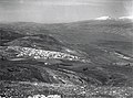
In 1881, the PEF's Survey of Western Palestine described Hunin as "[a] village, built of stone, joining on to ruined Crusading castle [..], and containing about 100 Moslems. The situation is on a low ridge just before the hills drop down to the east to the Huleh Valley; the hills round are uncultivated, covered with low scrub, but in the valleys there is some arable land. Water is obtained from numerous cisterns; a birket [pool, reservoir[13]] and spring to the south-east."[14][15]
British Mandate period
The
In April 1924, Hunin and six other Shiite villages, and an estimated 20 other settlements, were transferred from the
In the 1931 census of Palestine, the population of Hunin was 1,075, all Muslims, in a total of 233 houses.[21]
In the
In 1945, Kibbutz Misgav Am was established on what was traditionally the northern part of village land.[5]
-
 Hunin 1937
 -
 Hunin 1937
 -
 Hunin, 1946


1948 and aftermath
A Palmach raid in May 1948 led to many of the inhabitants fleeing to Lebanon, leaving 400 in the village.[24] Four village women were raped and murdered by Israeli soldiers during the summer.[24]
During a meeting in August 1948, the mukhtars of Hunin and other Shi'ite villages met with the Jews of kibbutz Kfar Giladi, declaring their willingness to be good citizens of Israel.[6][24] Their proposal was conveyed to the Israeli government, where it received enthusiastic support from the Minorities Minister Bechor-Shalom Sheetrit.[6][20] A report was made by the Ministry of Minority Affairs recommending that such an agreement be reached with the 4,700 or so Shi'ites in the region to promote friendly relations with southern Lebanon, to take advantage of the Shi'ites' poor relationship with the majority Sunnis, and to enhance the prospect of a future extension of the border.[19] This proposal was not accepted, despite the support of the Minister of Minority Affairs, Sheetrit.[19] In August, more inhabitants of Hunin were forced to flee by the IDF.[25] On 3 September 1948, the IDF raided the village blowing up 20 houses, killing a son of the mukhtar and 19 others and expelling the remaining villagers.[20][24] Most of the villagers took refuge in Shiite villages in Lebanon.[20]
In 1951, Moshav Margaliot was established just south of the village site.[5]
See also
- Hula massacre (31 October - 1 November 1948) perpetrated by the IDF in Hula, a Lebanese Shi'a village 3 km from Hunin
- Shia villages in Palestine
References
- ^ Palmer, 1881, p. 21
- ^ a b c d Government of Palestine, Department of Statistics, 1945, p. 9
- ^ a b Government of Palestine, Department of Statistics. Village Statistics, April, 1945. Quoted in Hadawi, 1970, p. 69
- ^ Morris, 2004, p. xvi, village #6. Also gives causes of depopulation.
- ^ a b c d Khalidi, 1992, p. 455
- ^ a b c Gelber, 2006, p. 222
- ^ a b c d Freundlich, Amir (September 2007). "Hunin Fortress: Preliminary plan for conservation and development". Conservation Department: Heritage Preservation in Israel. Israel Antiquities Authority. Retrieved 28 February 2021.
- ^ a b c Pringle (1997), p. 79
- ^ Sharon, 2007, pp. 108-112
- ^ Sharon, 2013, p. 289
- ^ Robinson, 1856, pp. 370-371
- ^ Guérin, 1880, pp. 370-372
- ^ Wiktionary, Etymology: بركة
- ^ Conder and Kitchener, 1881, SWP I, p. 87
- ^ Conder and Kitchener, 1881, SWP I, pp. 123-125
- ^ Fromkin, 1989, p. ?
- ^ MacMillan, 2001, pp. 392–420
- ^ Exchange of Notes Archived 2008-09-09 at the Wayback Machine Constituting an Agreement respecting the boundary line between Syria and Palestine from the Mediterranean to El Hammé. Paris, March 7, 1923.
- ^ a b c Sindawi, Khalid (2008). Are there any Shi'te Muslims in Israel?", Holy Land Studies, Vol. 7, No. 2, 183–199.
- ^ doi:10.3751/60.4.13.
- ^ Mills, 1932, p. 107[dead link] ([https://ecf.org.il/media_items/1088 Full Document PDF[ p.118, Original p. 107)
- ^ Government of Palestine, Department of Statistics. Village Statistics, April, 1945. Quoted in Hadawi, 1970, p. 119
- ^ Government of Palestine, Department of Statistics. Village Statistics, April, 1945. Quoted in Hadawi, 1970, p. 169
- ^ a b c d Morris, 2004, pp. 249, 447–448
- ^ Morris, 2004, p. 249
Bibliography
- Conder, C.R.; Kitchener, H.H. (1881). The Survey of Western Palestine: Memoirs of the Topography, Orography, Hydrography, and Archaeology. Vol. 1. London: Committee of the Palestine Exploration Fund.
- ISBN 978-0-8050-8809-0.
- Government of Palestine, Department of Statistics (1945). Village Statistics, April, 1945.
- ISBN 1-84519-075-0.
- Guérin, V. (1880). Description Géographique Historique et Archéologique de la Palestine (in French). Vol. 3: Galilee, pt. 2. Paris: L'Imprimerie Nationale.
- Hadawi, S. (1970). Village Statistics of 1945: A Classification of Land and Area ownership in Palestine. Palestine Liberation Organization Research Center.
- ISBN 0-88728-224-5.
- ISBN 978-0-7195-6237-2.
- Mills, E., ed. (1932). Census of Palestine 1931. Population of Villages, Towns and Administrative Areas. Jerusalem: Government of Palestine.
- ISBN 978-0-521-00967-6.
- Palmer, E.H. (1881). The Survey of Western Palestine: Arabic and English Name Lists Collected During the Survey by Lieutenants Conder and Kitchener, R. E. Transliterated and Explained by E.H. Palmer. Committee of the Palestine Exploration Fund.
- Petersen, Andrew (2001). A Gazetteer of Buildings in Muslim Palestine (British Academy Monographs in Archaeology). Vol. I. ISBN 978-0-19-727011-0.
- )
- Robinson, E.; Smith, E. (1856). Later Biblical Researches in Palestine and adjacent regions: A Journal of Travels in the year 1852. London: John Murray.
- ISBN 90-04-11083-6.p. 49
- ISBN 978-90-04-15780-4.
- ISBN 978-90-04-25097-0.
External links
- Welcome to Hunin at PalestineRemembered.com
- Hunin, Zochrot
- Hunin, Villages of Palestine
- Survey of Western Palestine, map 2: IAA, Wikimedia commons
- Hunin, from the Khalil Sakakini Cultural Center
