
User:Sprigitgirl/sandbox
Merw (in Turkmen) | |
Turkmen | |
| Site notes | |
|---|---|
| Condition | In ruins |
Asia-Pacific | |
 | |
| History of Greater Iran | |
|---|---|
| 1407–1468 | |
| Aq Qoyunlu Turcomans | 1378–1508 |
| Safavid Empire | 1501–1722 |
| Mughal Empire | 1526–1857 |
| Hotak dynasty | 1722–1729 |
| Afsharid Iran | 1736–1750 |
| Zand dynasty | 1750–1794 |
| Durrani Empire | 1794–1826 |
| Qajar Iran | 1794–1925 |
Akhsiket was a city in the Ferghana Valley in eastern Uzbekistan, located on the banks of the Amu Darya river near today's Namangan.
Earliest artifacts from the site show habitation from as early as the 2nd century BC. The site was permanently abandoned during the Mongol invasions in 1220 AD. In the Early Islamic period Akhsiket was a regional capital in Ferghana. It was a center for crucible steel production during this time, and several archaeological excavations in the latter half of the 20th century and early 21st century have revealed the character of the city during its lifetime.
History
Merv has prehistoric roots: archaeological surveys have revealed many traces of village life as far back as the 3rd millennium BC and have associated the area culturally with the
Under the
After the
Arab occupation and influence
Merv gained renewed importance in February 748 when the Iranian general
Throughout the Abbasid era (750-1258), Merv remained the capital and most important city of
During this period Merv, like
As the caliphate weakened, Arab rule in Merv was replaced by that of the
Turks in Merv
| History of the Turkic peoples pre–14th century |
|---|
 |
In 1037, the
During this period Merv expanded to its greatest size—Arab and
Sanjar's rule, marked by conflict with the
Mongols in Merv
In 1221 Merv opened its gates to
- "The Mongols ordered that, apart from four hundred artisans. .., the whole population, including the women and children, should be killed, and no one, whether woman or man, be spared. To each [Mongol soldier] was allotted the execution of three or four hundred Persians. So many had been killed by nightfall that the mountains became hillocks, and the plain was soaked with the blood of the mighty."
Some historians[
Excavations revealed drastic rebuilding of the city's fortifications in the aftermath, but the prosperity of the city had passed. The Mongol invasion spelt the eclipse of Merv and indeed of other major centres for more than a century. After the Mongol conquest, Merv became part of the
Uzbeks in Merv and its final destruction
In 1505 the
Nineteenth century
| History of Turkmenistan |
|---|
.jpg) |
|
|
Merv passed to the
Remains
Some exploratory excavations at Merv were conducted in 1885[11] by the Russian general A.V. Komarov, the governor of the Transcaspian oblast, 1883–89; Komarov employed his Tsarist troops as excavators and published his collection of trophy artifacts and coins from the area in 1900.[12] The first fully professional dig was directed by Valentin Alekseevich Zhukovsky of the Imperial Archaeological Commission, in 1890 and published in 1894.[13] The American Carnegie Institute's excavations were under the direction of a geologist, Raphael Pumpelly, and a German archaeologist, Hubert Schmidt.
Merv is currently the focus of the Ancient Merv Project (initially as the International Merv Project).[14] From 1992 to 2000, a joint team of archaeologists from Turkmenistan and the UK have made remarkable discoveries. In 2001, a new collaboration was started between the Institute of Archaeology, University College London and the Turkmen authorities. [citation needed] This Ancient Merv Project is concerned with the complex conservation and management issues posed by this remarkable site, furthering our understanding of the site through archaeological research, and disseminating the results of the work to the widest possible audience.
Organization of remains
Merv consists of a few discrete walled cities very near to each other, each of which was constructed on uninhabited land by builders of different eras, used, and then abandoned and never rebuilt. Four walled cities correspond to the chief periods of Merv's importance: the oldest, Erkgala, corresponds to Achaemenid Merv, and is the smallest of the three. Gäwürgala (also known as Gyaur Gala), which surrounds Erkgala, comprises the
Erk Gala

Erk Gala (from
Gäwürgala
The foundation of Gäwürgala (
Gäwürgala's most visible remaining structures are its defensive installations. Three walls, one built atop the next, are in evidence. A Seleucid wall, graduated in the interior and straight on the exterior, forms a platform for the second, larger wall, built of mudbricks and stepped on the interior. The form of this wall is similar to other
Even after the foundation of Soltangala by Abu Muslim at the start of the Abbasid dynasty, Gäwürgala persisted as a suburb of the larger Soltangala. In Gäwürgala are concentrated many Abbasid-era "industrial" buildings: pottery kilns, steel, iron and copper-working workshops and so on. A well-preserved pottery kiln has an intact vaulted arch support and a square firepit. Gyaur Gala seems to have been the craftsmens' quarters throughout the Abbasid and pre-Seljuk periods (Herrmann, "Seventh Season" 13).[16]
Soltangala

Soltangala (from Sultan Qala, the sultan's fortress) is by far the largest of Merv's cities. Textual sources (Herrmann 1999) establish that it was
However, the most important of Soltangala's surviving buildings are Seljuk constructions. In the 11th century CE, the nomadic Oghuz Turks, formerly vassals of the Khwarazmshah in the northern steppes, began to move southward under the leadership of the Seljuk clan and its ruler Togrul Beg. Togrul's conquest of Merv in 1037 revitalized the city; under his descendants, especially Sanjar, who made it his residence, Merv found itself at the center of a large multicultural empire.
Evidence of this prosperity is found throughout the Soltangala. Many of these are concentrated in Soltangala's citadel, the Shahryar Ark (Persian, "the Sovereign's citadel") of the, located on its east side. In the center of the Sharhryar Ark is located the Seljuk palace probably built by Sanjar. The surviving mud brick walls lead to the conclusion that this palace, relatively small, was composed of tall single-story rooms surrounding a central court along with four axial iwans at the entrance to each side (Ettinghausen 276). Low areas nearby seem to indicate a large garden which included an artificial lake; similar gardens were found in other Central Asian palaces (Williams 2002). Any remnants of interior or exterior decoration have been lost due to erosion or theft.

Another notable Seljuk structure within the Shahryar Ark is the kepderihana (from Persian, "Kaftar Khana, or "pigeon house", i.e., the columbarium). This mysterious building, among the best-preserved in the whole Merv oasis, comprises one long and narrow windowless room with many tiers of niches across the walls. It is believed by some [sources] that the kepter khana (there are more elsewhere in Merv and Central Asia) was indeed a pigeon roost used to raise pigeons, in order to collect their dung which is used in growing the melons for which Merv was famous. Others, just as justifiably (Herrmann 1999), see the kepderihanas as libraries or treasuries, due to their location in high status areas next to important structures.
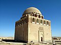
The best-preserved of all the structures in Merv is the 12th-century
A final set of
Many ceramics have also been recovered from the Abbasid and Seljuk eras, primarily from Gäwürgala, the city walls of Soltangala, and the Shahryar Ark. The Gäwürgala ware was primarily late
Shaim Kala
Shaim Kala was built in the 7th century
Abdyllahangala
Abdyllahangala is the post medieval Timrid era city to the south of the main complex.[20]
Gallery
-
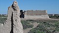 Great Kyz Qala
 -
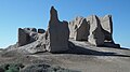 Little Kyz Qala
 -
 part of Kyz Qala
 -
 Sultan Sanjar Mausoleum
 -
 Mosque (Merv)
 -
 Merv coin
 -
 Soltan Sanjaryň mawzoleýi


.png)
Geography
The oasis of Merv is situated on the
Merv is advantageously situated in the inland delta of the Murghab River, which flows from its source in the Hindu Kush northwards through the Garagum desert. The Murghab delta region, known to the Greeks as
to Bukhara and Samarkand.This place was a stop on the Silk Road during the time of the Han dynasty. Here merchants could trade for fresh horses or camels at this oasis city.
Demographics
The present inhabitants of the oasis are primarily
Economy
The oasis is irrigated by an elaborate system of canals cut from the Murghab. The country has at all times been renowned throughout the East for its fertility. Every kind of cereal and many fruits grow in great abundance, e.g. wheat, millet, barley and melons, also rice and cotton. Cotton seeds from archaeological levels as far back as the 5th century are the first indication that cotton textiles were already an important economic component of the Sassanian city.
Carpets from the region of Merv are sometimes considered superior to the Persian.[citation needed] They also make felts and a rough cloth of sheep's wool.
Climate
Merv is dry and hot in summer and cold in winter. The heat of summer is oppressive. The wind raises clouds of fine dust which fill the air, rendering it opaque, almost obscuring the noonday sun. These clouds make breathing difficult. In winter the climate is pleasant. Snow falls rarely, and when it does, it melts at once. The annual rainfall rarely exceeds 125 mm, and there is often no rain from June until October. While in summer temperatures can reach 45 °C (113 °F), in winter it they can be as low as −7 °C (19 °F). The average yearly temperature is 16 °C (61 °F).
International relations
Twin towns and sister cities
Merv is
 Balkh;
 Baku;
Baku; Wuhan;
 Zagreb;
 Cairo;
- Hamedan and Isfahan;
 Baghdad, Karbala and Kirkuk;
- Jerusalem;
 Venice;
 Kuwait City;
 Lahore;
 Gaza;
Gaza; Saint Petersburg;
 Medina and Mecca;
 Damascus and Aleppo;
 Khujand;
 Istanbul, Konya, Bursa and İzmir;
- Old Urgench;
 Dubai;
 Bukhara and Samarkand.
See also
- Gunar Tepe
References and sources
- References
- ^ Vendidad, Faragard-1
- ^ "Unmanned Aerial Vehicle Photography: Exploring the Medieval City of Merv, on the Silk Roads of Central Asia" by Tim Williams in Archaeology International, Issue 15 (2011–2012), pp. 74–88.
- ^ Antiochia Margiana
- ^ http://www.tourstoturkmenistan.com/en/sights/merv-mary/ruins-in-merv.html
- ^ http://www.medeniyet.gov.tm/index.php/en/culture-dialogue/119-gadymy-merwde-butparazlygy%C5%88-d%C3%B6re%C3%BD%C5%9Fi
- ^ http://www.asthabharati.org/Dia_July%20011/suni.htm
- ^ Muir pp. 295–6
- ^ Harvard University. Center for Middle Eastern Studies (1999). Harvard Middle Eastern and Islamic review, Volumes 5–7. Center for Middle Eastern Studies, Harvard University. p. 89. Retrieved 2010-11-28.
- ^ Cary-Elwes, Columba. China and the Cross. (New York: P. J. Kennedy and Sons, 1956)
- ^ "geography.about.com". Retrieved 7 October 2014.
- ^ Merv, controlling the route from Herat, was conquered by Komarov's troops without much resistance in 1885, part of the Great Game: André Kamev, Le Turkménistan 2005:104
- ^ Fredrik T. Hiebert, Kakamyrat Gurbansähedow and Hubert Schmidt, A Central Asian Village at the Dawn of Civilization, Excavations at Anau (University of Pennsylvania) 2003:3.
- ^ V.A. Zhukovsky, Razvalinii starogo Merva (St Peterburg, 1894).
- ^ Institute of Archaeology, University College London : Ancient Merv Project.
- ^ A galaxy of ancient Merv.
- ^ Dr. Ragheb Elsergany, Merv city.
- ^ Herrmann 2000
- ^ Herrmann 1999
- ^ Merv at UCL Institute of Archaeology.
- ^ State Historical and Cultural Park “Ancient Merv” at UNESCO.
- ^ "A. Feuerbach, 'Crucible Damascus Steel: a Fascination for Almost 2,000 Years' JOM Journal of the Minerals, Metals and Materials Society 58 (5), 48–50". Retrieved 7 October 2014.
- ^ Donald B. Wagner (continuing from Joseph Needham), Science and Civilisation in China: 5. Chemistry and Chemical Technology: part 11 Ferrous Metallurgy (Cambridge University Press 2008), 265 357.
- Sources
This article incorporates text from a publication now in the public domain: Chisholm, Hugh, ed. (1911). Encyclopædia Britannica (11th ed.). Cambridge University Press. {{cite encyclopedia}}: Missing or empty |title= (help)
External links
- British Museum Research Project
- Hazlitt's Classical Gazetteer
- Ancient Merv Project UCL
- Merv Digital Media Archive (creative commons-licensed photos, laser scans, panoramas), particularly focusing on Sultan Kala (Gala), with data from a University College London/CyArk research partnership
- Tahmuras, the mythical father and founder of Merv
| Periods |
|  | ||||
|---|---|---|---|---|---|---|
| Types | ||||||
| Elements | ||||||
| Traditional cities | ||||||
| Theory and analysis | ||||||
| Lists | ||||||