
Al-Mansura, Safad
- See El Mansurah (disambiguation) for other sites with similar names.
Al-Mansura
المنصوره | ||
|---|---|---|
Village | ||
 Al-Mansura (Mansoura) marked on John MacGregor's map. January 1869. | ||
| Etymology: Mansûr’s place[1] | ||
.jpg) 1870s map 1870s map .jpg) 1940s map 1940s map.jpg) modern map modern map .jpg) 1940s with modern overlay map 1940s with modern overlay mapA series of historical maps of the area around Al-Mansura, Safad (click the buttons) | ||
Geopolitical entity Mandatory Palestine | | |
| Subdistrict | Safad | |
| Date of depopulation | May 25, 1948[3] | |
| Population (1945) | ||
| • Total | 360[2] | |
| Cause(s) of depopulation | Whispering campaign | |
| Current Localities | She'ar Yashuv[4] | |
Al-Mansura (
History
Ottoman period
The Christian
In January 1869
In 1881 the PEF's Survey of Western Palestine described the village as consisting "of stone and mud hovels on the plain, surrounded by arable land; river near; the village contains about seventy Moslems."[8]
British Mandate of Palestine period
In the
In the 1945 statistics the population was 360, all Muslims,[2] owning 1,254 dunams of land, while Jews owned 175 dunams, and 115 was publicly owned, according to an official land and population survey.[11] Of this, 1,424 dunams were allocated for plantations and irrigable land,[12] while 5 dunams were classified as built-up areas.[13]
1948, and after
The village was depopulated during the
The settlement She'ar Yashuv is located on village lands, about 1 km northeast of the village site. In 1992 the village site was described as: "The village has been completely obliterated and it is difficult to identify any trace of its former buildings. The site has been converted into a fish hatchery and contain pools for this purpose. Between the pools there is a narrow strip of thorns and trees."[4]
-
 Hula Bedouin making buffalo butter in 1925, using the same methods as described by W.M. Thomson in 1857.
 -
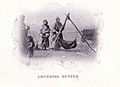 Churning butter, Palestine, 1904.
 -
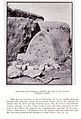 Hula beehive, 1904.


See also
References
- ^ Palmer, 1881, p. 29
- ^ a b Government of Palestine, Department of Statistics, 1945, p. 10
- ^ a b Morris, 2004, p. xvi, village #7. Also gives cause of depopulation.
- ^ a b Khalidi, 1992, p. 474
- ^ Thomson, 1859, vol 1, pp. 388-389
- ^ MacGregor, 1869, pp. 241-245, 247.
- ^ MacGregor, 1869, p. 241, cited in Rajab, 1989, pp. 129, 131
- ^ Conder and Kitchener, 1881, SWP I, p. 89
- ^ Barron, 1923, Table XI, Sub-district of Safad, p. 41
- ^ Mills , 1932, p. 108
- ^ Government of Palestine, Department of Statistics. Village Statistics, April, 1945. Quoted in Hadawi, 1970, p. 70 Archived 2015-09-24 at the Wayback Machine
- ^ Government of Palestine, Department of Statistics. Village Statistics, April, 1945. Quoted in Hadawi, 1970, p. 119 Archived 2015-09-24 at the Wayback Machine
- ^ Government of Palestine, Department of Statistics. Village Statistics, April, 1945. Quoted in Hadawi, 1970, p. 170
- ^ Morris, 2004, p. 251, note #707, p. 303
Bibliography
- Assis, Royee (2017-09-11). "She'ar Yashuv" (129). Hadashot Arkheologiyot – Excavations and Surveys in Israel.
{{cite journal}}: Cite journal requires|journal=(help) - Barron, J.B., ed. (1923). Palestine: Report and General Abstracts of the Census of 1922. Government of Palestine.
- Conder, C.R.; Kitchener, H.H. (1881). The Survey of Western Palestine: Memoirs of the Topography, Orography, Hydrography, and Archaeology. Vol. 1. London: Committee of the Palestine Exploration Fund.
- Government of Palestine, Department of Statistics (1945). Village Statistics, April, 1945.
- Hadawi, S. (1970). Village Statistics of 1945: A Classification of Land and Area ownership in Palestine. Palestine Liberation Organization Research Center. Archived from the original on 2018-12-08. Retrieved 2009-08-18.
- ISBN 0-88728-224-5.
- Macgregor, J. (1869). The Rob Roy on the Jordan: Nile, Red Sea, & Gennesareth, Etc. : a Canoe Cruise in Palestine and Egypt and the Waters of Damascus. London: John Murray.
- Mills, E., ed. (1932). Census of Palestine 1931. Population of Villages, Towns and Administrative Areas. Jerusalem: Government of Palestine.
- ISBN 978-0-521-00967-6.
- Palmer, E.H. (1881). The Survey of Western Palestine: Arabic and English Name Lists Collected During the Survey by Lieutenants Conder and Kitchener, R. E. Transliterated and Explained by E.H. Palmer. Committee of the Palestine Exploration Fund.
- ISBN 0-7141-2517-2.
- Harper & Brothers.
External links
- Welcome To al-Mansura
- al-Mansura (Safed), Zochrot
- Survey of Western Palestine, Map 2: IAA, Wikimedia commons
