
Majdal Yaba
Majdal Yaba
مجدل يابا Majdal al-Sadiq, Majdal Yafa | |
|---|---|
 A street in the Palestinian village of Majdal Yaba, November 1917 | |
| Etymology: "Tower of [our] Father" or "Tower of Yafa" and later "Tower of Sadiq" or "The watch-tower of Yâba"[1] | |
.jpg) 1870s map 1870s map .jpg) 1940s map 1940s map.jpg) modern map modern map .jpg) 1940s with modern overlay map 1940s with modern overlay mapA series of historical maps of the area around Majdal Yaba (click the buttons) | |
Majdal Yaba (
Incorporated into

History
Antiquity
As early as the second century BCE in
Arab Caliphate era
On 27 April 750, Abdullah ibn Ali, the
In 975 the army of
Crusader, Ayyubid and Mamluk rule

The Crusaders conquered the
The tyranny of a crusader lord Hugh of Ibelin[16] in Majdal Yaba near Nablus was reported by Usama ibn Munqidh[17][18] in 1156 CE; he imposed excessive taxes on Muslims, and required Muslims to pay four times as much tax as Christians nearby.[19] The inhabitants of eight villages which included Ibn Qudamah family left their homes in 1156 AC and migrated to Damascus, where they founded Al-Salihiyah suburb.
In 1177, the Muslim
While under
June 1240 CE marked the arrival of the English crusade led by
In 1266, after the fall of Jaffa to the
Ottoman period
Majdal Yaba was apparently repopulated when Palestine was incorporated into the
In the
On March 3, 1799, General

In the 19th century, the village was named Majdal al-Sadiq after Sheikh Muhammad al-Sadiq al-Jamma'ini, the chief of the village who hailed from the prominent Rayyan clan. The Rayyan were a branch of the Bedouin Bani Ghazi tribe that emigrated to Palestine from Jordan in the 17th century.[30] According to Eli Smith, in 1843, the fortress (known as the "Rayyan Fortress") in the village was in ruins.[31]

On Thursday, November 7, 1850 James Finn future British Consul to Jerusalem and Palestine, visited the village and found it and the castle in a very dilapidated condition, he met Sheikh Al Sadiq family, and slept in the castle for a night, he surveyed the church attached to the castle and saw the Greek inscription upon the lintel signifying Martyr Memorial Church of the Holy Herald.[32] On leaving Mejdal he descended to Ras el 'Ain ("head of the springs") at half an hour's distance, a site which he believed to be identical with the ancient city of Antipatris.[32]
When Edward Robinson visited in 1852, he reported that the fortress had been rebuilt and also served as a palace for the ruling sheikh. Sheikh al-Sadiq, however, had been banished by the Ottomans.[31] In the 1850s, the Rayyan controlled 22-25 villages in the nahiya of Jamma'in West in Sanjak Nablus,[30] with Majdal Yaba being their main village, where they maintained a fortress and manor.[33] During this time, however, they were embroiled in war with their rival clan, the Qasim — who controlled the Jamma'in East area and also belonged to the Bani Ghazi tribe.[30][33]
In 1859, Sulayman Rayyan was in control of Majdal Yaba,[30] and by 1860 the Rayyan clan had lost all of their influence in the sanjak
after they were defeated by the Qasims.[33] The Rayyan continued to live in and rule Majdal Yaba, but the village ceased to be a center of power.[23] According to the PEF's Survey of Western Palestine (SWP), the Rayyan family were "ruined by the Turkish Government."[34] Victor Guérin visited in 1870.[35]
In 1870/1871 (1288
Members of SWP who visited in 1873 reported a large building of "massive masonry", probably a former church, with a side door inscribed in Greek "Memorial of
In 1888, a school was founded in Majdal Yaba.[23]
British Mandate period
Majdal Yaba was captured by British troops the 9th of November, 1917.[39]
In the 1922 census of Palestine conducted by the British Mandate authorities, there were 726 inhabitants living in the village; 3 Jews and 723 Muslims,[40] rising to 966, all Muslim, in a total of 227 houses in the 1931 census.[41] The layout of the village resembled a parallelogram and its houses were built close together, being only separated by narrow alleys. They were built of mud and straw or stone and cement. Each neighborhood was inhabited by a single hamula ("clan") and contained a diwan for public meetings and receiving guests.[23] The Rayyan family had still not recovered by the beginning of the Mandate Period; it was known to be impoverished, as was the Qasim family. "Dar az-zalimin kharab [the home of the oppressors is ruined]," said peasants when they passed by their kursis.[42] In 1935, a mosque was built in Majdal Yaba and the Ottoman-built school had reopened in 1920, enrolling 147 students in the mid-1940s. There was also a clinic in the village. Agriculture was the basis of the economy, with farmers planting wheat, corn, barley, vegetables, and sesame. They also tended fruit orchards, particularly citrus. Artesian wells irrigated the fields.[23]
In the 1945 statistics Majdal Yaba had a population of 1,520 Muslim inhabitants[2] with a total of 26,332 dunams of land.[3] Of this, a total of 2,481 dunums of village land was used for citrus and bananas, 110 dunams were plantations or irrigable land, 13,906 dunums were used for cereals,[43] while 59 dunams were classified as built-up urban areas.[44]
-
 Majdal Yaba during French Invasion of 1799
 -
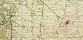 Al-Muzayri'a 1941 1:20,000
 -
 Al-Muzayri'a 1945 1:250,000
 -
 Families prior to 1948


1948 war and aftermath
-
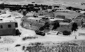 Majdal Yaba, July 1948
 -
 Majdal Yaba, February 1949
 -
 Majdal Yada, March 1949
 -
 Member of Harel Brigade at Majdal Yaba, 1949
 -
 Damra family tomb in Majdal Yaba's Eastern Cemetery


Majdal Yaba was in the territory allotted to the Arab state under the 1947
The Israeli town of Rosh HaAyin — which today is a city — was built on village lands in 1950, and in 1953, the Jewish kibbutz of Givat HaShlosha was established on village lands. According to Palestinian historian Walid Khalidi, the Rayyan Fortress still "crowns the site" in addition to the tomb of Sheikh Muhammad Al-Sadiq, and a part of the village cemetery still remains. In 1992 the fortress was "slowly crumbling" and the dome of the tomb was severely cracked.[5] The ruins of Mirabel Castle have been recently restored and made accessible as part of the Israeli national park of Migdal Afek.
See also
- Depopulated Palestinian locations in Israel
- Migdal Afek, Israeli national park centered around the ruins of Mirabel Castle
- Vassals of the Kingdom of Jerusalem of the Crusader period
References
- ^ Palmer, 1881, p. 238
- ^ a b Government of Palestine, Department of Statistics, 1945, p. 30
- ^ a b c Government of Palestine, Department of Statistics. Village Statistics, April, 1945. Quoted in Hadawi, 1970, p. 67
- ^ Morris, 2004, p. xviii, village #388. Also gives cause of depopulation.
- ^ a b c d Khalidi, 1992, p. 397
- ^ Morris, 2004, p. xxii, settlement #99
- ^ Morris, 2004, p. xxii, settlement #100
- ^ JSTOR 43587090.
- ^ Welcome to Majdal Yaba Palestine Remembered.
- ^ משה גלעד, היא חזרה: מצודת היופי הפלאי, גלריה הארץ, 25.3.2021
- ^ Murphy-O'Connor, 2008, p. 187.
- ^ a b c Le Strange, 1890, pp. 55-56
- ^ Gil, 1997, p. 88
- ^ a b c d Pringle, 1997, p. 67
- ^ Röhricht, 1893, RRH, p. 110, No 423; cited Pringle, 1998, p. 105
- ^ [1] Archived 2012-10-14 at the Wayback Machine Ibn Tulun القلائد الجوهرية في تاريخ الصالحية.
- ^ [2] Usama Ibn Munqidh.
- ^ [3] Usama Ibn Munqidh.
- ^ [4] Archived 2012-10-14 at the Wayback Machine Ibn Tulun.
- ^ Conder, 1897, p. 137
- ^ Pringle, 1998, p. 29
- ^ Conder, 1897, p. 279
- ^ a b c d e f Khalidi, 1992, p. 396
- ^ Khalil 'Athamneh, Palestine under Ayyobid and Mamluk Rule P. 137 - 151
- ^ Deir Ghassaneh. (in Arabic)
- ^ Hütteroth and Abdulfattah, 1977, p. 137
- ^ Marom, Roy (2022-11-01). "Jindās: A History of Lydda's Rural Hinterland in the 15th to the 20th Centuries CE". Lod, Lydda, Diospolis. 1: 17.
- ^ Doguereau, 2002, p. 76 footnote no. 6
- ^ Bourrienne, 1891, p. 175
- ^ a b c d Doumani, 1995, p.48. Doumani states that the Rayyan controlled 25 villages, while Schölch states 22.
- ^ a b Robinson and Smith, 1856, p. 140
- ^ a b Finn, 1877, pp. 128-132
- ^ a b c Schölch, 1986, pp. 173, 211. Quoted in Khalidi, 1992, p. 396
- ^ Conder and Kitchener, 1882, SWP II, p. 379; cited in Schölch, 1993, p. 227
- ^ Guérin, 1875, pp. 131-3
- ^ Grossman, David (2004). Arab Demography and Early Jewish Settlement in Palestine. Jerusalem: Magnes Press. p. 252.
- ^ Conder and Kitchener, 1882, SWP II, pp. 360- 361
- ^ Conder and Kitchener, 1882, SWP II, p. 286
- ^ "EL MEJDEL, JAFFA AND WEST COUNTRY TROOPS [Main Title]".
- ^ Barron, 1923, Table VII, Sub-district of Ramleh, p. 22
- ^ Mills, 1932, p. 21.
- ^ Jaussen, J. A. Naplouse et Son District, (Paris, 1927) p. 138, p.141. Cited in Schölch, 1993, p.227.
- ^ Government of Palestine, Department of Statistics. Village Statistics, April, 1945. Quoted in Hadawi, 1970, p. 116
- ^ Government of Palestine, Department of Statistics. Village Statistics, April, 1945. Quoted in Hadawi, 1970, p. 166
- ^ "Map of UN Partition Plan". United Nations. Archived from the original on 2009-01-24. Retrieved 2009-02-09.
- ^ New York Times quoted in Khalidi, 1992, p.397.
- Abdul Karim Qassim.
Bibliography
- Barron, J.B., ed. (1923). Palestine: Report and General Abstracts of the Census of 1922. Government of Palestine.
- ISBN 978-1-4446-7930-4.
- Clermont-Ganneau, C.S. (1896). [ARP] Archaeological Researches in Palestine 1873-1874, translated from the French by J. McFarlane. Vol. 2. London: Palestine Exploration Fund. (pp. 340-341)
- Conder, C.R.; Kitchener, H.H. (1882). The Survey of Western Palestine: Memoirs of the Topography, Orography, Hydrography, and Archaeology. Vol. 2. London: Committee of the Palestine Exploration Fund.
- Conder, C.R. (1897). The Latin Kingdom of Jerusalem, 1099 to 1291 AD. London: Committee of the Palestine Exploration Fund.
- ISBN 0-313-32512-X.
- ISBN 0-520-20370-4.
- Finn, J. (1877). Byeways in Palestine. London: James Nisbet.
- ISBN 978-0-521-59984-9.
- Government of Palestine, Department of Statistics (1945). Village Statistics, April, 1945.
- Guérin, V. (1875). Description Géographique Historique et Archéologique de la Palestine (in French). Vol. 2: Samarie, pt. 2. Paris: L'Imprimerie Nationale.
- Hadawi, S. (1970). Village Statistics of 1945: A Classification of Land and Area ownership in Palestine. Palestine Liberation Organization Research Center.
- Hütteroth, Wolf-Dieter; Abdulfattah, Kamal (1977). Historical Geography of Palestine, Transjordan and Southern Syria in the Late 16th Century. Erlanger Geographische Arbeiten, Sonderband 5. Erlangen, Germany: Vorstand der Fränkischen Geographischen Gesellschaft. ISBN 3-920405-41-2.
- ISBN 0-88728-224-5.
- Laughlin, John Charles Hugh (2006). Fifty Major Cities of the Bible: From Dan to Beersheba. Taylor & Francis. ISBN 978-0-415-22315-7.
- Le Strange, G. (1890). Palestine Under the Moslems: A Description of Syria and the Holy Land from A.D. 650 to 1500. London: Committee of the Palestine Exploration Fund.
- Mills, E., ed. (1932). Census of Palestine 1931. Population of Villages, Towns and Administrative Areas. Jerusalem: Government of Palestine.
- ISBN 0-521-00967-7.
- Murphy-O'Connor, Jeremiah (2008). The Holy Land: An Oxford Archaeological Guide from Earliest Times to 1700. Oxford University Press US. ISBN 978-0-19-923666-4.
- Palmer, E.H. (1881). The Survey of Western Palestine: Arabic and English Name Lists Collected During the Survey by Lieutenants Conder and Kitchener, R. E. Transliterated and Explained by E.H. Palmer. Committee of the Palestine Exploration Fund.
- Petersen, Andrew (2001). A Gazetteer of Buildings in Muslim Palestine (British Academy Monographs in Archaeology). Vol. 1. ISBN 978-0-19-727011-0. (pp. 213–215.)
- ISBN 0521-46010-7.
- ISBN 0-521-39037-0.
- Rey, E.G. [in French] (1883). Les colonies franques de Syrie aux XIIme et XIIIme siècles (in French). Paris: A. Picard. (pp. 412-413)
- Robinson, E.; Smith, E. (1856). Later Biblical Researches in Palestine and adjacent regions: A Journal of Travels in the year 1852. London: John Murray.
- Röhricht, R. (1893). (RRH) Regesta regni Hierosolymitani (MXCVII-MCCXCI) (in Latin). Berlin: Libraria Academica Wageriana.
- Schölch, Alexander (1986): Palästina im Umbruch 1856-1882. Wiesbaden and Stuttgart: Franz Steiner Verlag.
- Schölch, Alexander (1993). Palestine in Transformation, 1856-1882: Studies in Social, Economic, and Political Development. ISBN 0-88728-234-2.
- van de Velde, C.W.M. (1858). Memoir to Accompany the Map of the Holy Land. Gotha: Justus Perthes.
External links
- Welcome To Majdal Yaba
- Majdal Yaba\ al-Sadiq, Zochrot
- Survey of Western Palestine, Map 14: IAA, Wikimedia commons
