
Kasla, Jerusalem
Kasla
كسلا | ||
|---|---|---|
 Kasla was located on the top of the hill | ||
| Etymology: from personal name[1] | ||
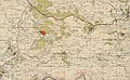
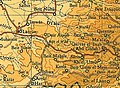
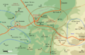
.jpg) 1870s map 1870s map .jpg) 1940s map 1940s map.jpg) modern map modern map .jpg) 1940s with modern overlay map 1940s with modern overlay mapA series of historical maps of the area around Kasla, Jerusalem (click the buttons) | ||
Geopolitical entity Mandatory Palestine | | |
| Subdistrict | Jerusalem | |
| Date of depopulation | July 17–18, 1948[4] | |
| Area | ||
| • Total | 8,004 dunams (8.004 km2 or 3.090 sq mi) | |
| Population (1945) | ||
| • Total | 280[2][3] | |
| Cause(s) of depopulation | Military assault by Yishuv forces | |
| Current Localities | Ramat Raziel,[5] Ksalon[5] | |
Kasla was a
History
Antiquity

Kasla has been identified with the ancient Canaanite settlement of Chesalon,[6] and is believed to preserve its ancient name.[7][8] Chesalon is mentioned in the Book of Joshua as one of the landmarks on the boundary of Tribe of Judah.[9][10][11] During the Roman period, Chesalon was a Jewish settlement; it was mentioned in a document found in Wadi Murabba'at and dated to 55/6 CE.[12][13] Remains from the Roman era has been found in a cave by the village.[12] It is unknown whether it continued to exist in the aftermath of the First Jewish-Roman War and up to the Bar Kohkva Revolt.[12]
Ancient ashlar stones have been found at Kasla,[14] and the village had several khirbas, including a shrine for a local sage known as al-Shaykh Ahmad.[5]
In the early 4th century Onomasticon, Eusebius described Chasalon as a large village in the territory of Aelia.[15]
Ottoman era
Kasla was incorporated into the
In 1838, Kesla was noted as a Muslim village in the el-Arkub district, southwest of Jerusalem.[17][18]
In 1863 Victor Guérin described it a being situated on a ridge,[19] while an Ottoman village list of about 1870 showed Kesla with a population of 83, in 29 houses, though the population count included men only. It was also noted that to was located 3 1/2 to 4 hours west of Jerusalem.[20][21]
In 1883, the PEF's Survey of Western Palestine described Kesla as "a small stone village in a conspicuous position on the top of a rugged ridge, with a deep valley to the north. There is a spring to the east, and two more in a valley to the south. This is the site of Chesalon."[22]
In 1896 the population of Kesla was estimated to be about 207 persons.[23]
British Mandate era
In the 1922 census of Palestine conducted by the British Mandate authorities, Kasala had a population of 233 Muslims,[24] increasing in the 1931 census to 299 Muslims, in 72 houses.[25]
In the 1945 statistics, the village had a population of 280 Muslims,[2] while the total land area was 8,004 dunams, according to an official land and population survey.[3] Of this, 440 were used for plantations and irrigable land, 2,265 for cereals,[26] while 10 dunams were classified as built-up areas.[27]
-
 Kasla 1943 1:20,000 (below centre)
 -
 Kasla 1945 1:250,000
 -
 Kasla May 10, 1948 (lower right quadrant)


.png)
1948, and aftermath
Kasla, along with four other villages, were overtaken by the Israeli
Israel established two moshavs on Kasla's land: in 1948, Ramat Raziel; while in 1952 Ksalon was founded 1 km south of the village site, on the archeological site named Khirbat Sa'ra.[5]
In 1992 the village site was described: "Wild grass covers the entire site and grows amid the rubble of the stone houses, which is difficult to distinguish from the rubble of ruined terraces. Almond trees grow on top of the mountain and cactuses grow along the site’s southern slopes. Northeast of the village, two carob trees are surrounded by the remains of a vineyards. On the slopes, thick wild grass grows on several terraces, which are still intact."[5]
-
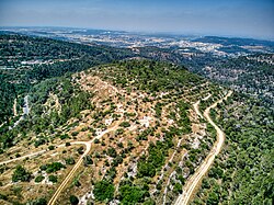
 The hill on which Kasla was located and behind it, Ksalon which was built on its lands
 -
 The saddle between the two hills of Kasla
 -
 The location of the houses of Kasla


References
- ^ Palmer, 1881, p. 298
- ^ a b Department of Statistics, 1945, p. 25
- ^ a b c Government of Palestine, Department of Statistics. Village Statistics, April, 1945. Quoted in Hadawi, 1970, p. 57
- ^ Morris, 2004, p. xx, village #338. Also gives cause of depopulation.
- ^ a b c d e Khalidi, 1992, p. 299
- ^ a b Khalidi, 1992, p. 298
- ^ Finkelstein et al, 2021, Excavations at Kiriath-jearim, 2019: Preliminary Report
- ^ Albright, 1923
- ^ Joshua 15:10
- ISBN 965-220-186-3
- ^ Yizhaqi, Arie (ed.): Madrich Israel (Israel Guide: An Encyclopedia for the Study of the Land), Vol.9: Judaea, Jerusalem 1980, Keter Press, p.383 (in Hebrew)
- ^ a b c Ganor and Klein, 2015, Khirbat el-Mitraz
- ISBN 978-965-217-429-1.
- ^ Dauphin, 1998, p. 903
- JSTOR 43587090.
- ^ a b Hütteroth and Abdulfattah, 1977, p. 155
- ^ Robinson and Smith, 1841, vol. 2, p. 364
- ^ Robinson and Smith, 1841, vol 3, 2nd appendix, p. 126
- ^ Guérin, 1869, p. 11
- ^ Socin, 1879, p. 156
- ^ Hartmann, 1883, p. 145, also noted 29 houses
- ^ Conder and Kitchener, 1883, pp. 25-26
- ^ Schick, 1896, p. 123
- ^ Barron, 1923, Table VII, Sub-district of Jerusalem, p. 15
- ^ Mills, 1932, p. 41
- ^ Government of Palestine, Department of Statistics. Village Statistics, April, 1945. Quoted in Hadawi, 1970, p. 103
- ^ Government of Palestine, Department of Statistics. Village Statistics, April, 1945. Quoted in Hadawi, 1970, p. 153
- ^ Morris, 2004, p. 436
Bibliography
- S2CID 163409706.
- Barron, J.B., ed. (1923). Palestine: Report and General Abstracts of the Census of 1922. Government of Palestine.
- Conder, C.R.; Kitchener, H.H. (1883). The Survey of Western Palestine: Memoirs of the Topography, Orography, Hydrography, and Archaeology. Vol. 3. London: Committee of the Palestine Exploration Fund.
- ISBN 0-860549-05-4.
- Department of Statistics (1945). Village Statistics, April, 1945. Government of Palestine.
- S2CID 235189602.
Chesalon (Kasla, G.R. 154132)
- Ganor, Amir; Klein, Eitan (2015). "Khirbat el-Mitraz: Final Report". Hadashot Arkheologiyot: Excavations and Surveys in Israel. 127. ISSN 1565-043X.
- Guérin, V. (1869). Description Géographique Historique et Archéologique de la Palestine (in French). Vol. 1: Judee, pt. 2. Paris: L'Imprimerie Nationale.
- Hadawi, S. (1970). Village Statistics of 1945: A Classification of Land and Area ownership in Palestine. Palestine Liberation Organization Research Center.
- Hartmann, M. (1883). "Die Ortschaftenliste des Liwa Jerusalem in dem türkischen Staatskalender für Syrien auf das Jahr 1288 der Flucht (1871)". Zeitschrift des Deutschen Palästina-Vereins. 6: 102–149.
- Hütteroth, Wolf-Dieter; Abdulfattah, Kamal (1977). Historical Geography of Palestine, Transjordan and Southern Syria in the Late 16th Century. Erlanger Geographische Arbeiten, Sonderband 5. Erlangen, Germany: Vorstand der Fränkischen Geographischen Gesellschaft. ISBN 3-920405-41-2.
- ISBN 0-88728-224-5.
- Mills, E, ed. (1932). Census of Palestine 1931. Population of Villages, Towns and Administrative Areas. Jerusalem: Government of Palestine.
- ISBN 978-0-521-00967-6.
- Palmer, E.H. (1881). The Survey of Western Palestine: Arabic and English Name Lists Collected During the Survey by Lieutenants Conder and Kitchener, R. E. Transliterated and Explained by E.H. Palmer. Committee of the Palestine Exploration Fund.
- Robinson, E.; Smith, E. (1841). Biblical Researches in Palestine, Mount Sinai and Arabia Petraea: A Journal of Travels in the year 1838. Vol. 2. Boston: Crocker & Brewster.
- Robinson, E.; Smith, E. (1841). Biblical Researches in Palestine, Mount Sinai and Arabia Petraea: A Journal of Travels in the year 1838. Vol. 3. Boston: Crocker & Brewster.
- Schick, C. (1896). "Zur Einwohnerzahl des Bezirks Jerusalem". Zeitschrift des Deutschen Palästina-Vereins. 19: 120–127.
- Socin, A. (1879). "Alphabetisches Verzeichniss von Ortschaften des Paschalik Jerusalem". Zeitschrift des Deutschen Palästina-Vereins. 2: 135–163.
External links
- Welcome To Kasla
- Kasla, Zochrot
- Survey of Western Palestine, Map 17: IAA, Wikimedia commons
- Kasla, from the Khalil Sakakini Cultural Center
