
Bayt Umm al-Mays
Bayt Umm al-Mays
بيت أم الميس | ||
|---|---|---|
| Etymology: The house of the meis-tree (Cordia myxa)[1] | ||
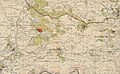
.jpg) 1870s map 1870s map .jpg) 1940s map 1940s map.jpg) modern map modern map .jpg) 1940s with modern overlay map 1940s with modern overlay mapA series of historical maps of the area around Bayt Umm al-Mays (click the buttons) | ||
Geopolitical entity Mandatory Palestine | | |
| Subdistrict | Jerusalem | |
| Date of depopulation | October 21, 1948[4] | |
| Area | ||
• Total | 1,013 dunams (1.013 km2 or 250 acres) | |
| Population (1945) | ||
• Total | 70[2][3] | |
| Cause(s) of depopulation | Military assault by Yishuv forces | |
Bayt Umm al-Mays was a small
Arab village in the Jerusalem Sub-district, located 14 km west of Jerusalem
..
The village was established and settled during the late
Har'el Brigade of Operation ha-Har
.
History
In 1863,
In 1883, the PEF's Survey of Western Palestine (SWP) noted at Beit Meis: "Ruined walls. No indication of age."[7]
British Mandate era
In the
-
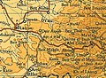
 Bayt Umm al-Mays 1943 1:20,000 (lower right quadrant)
 -
 Bayt Umm al-Mays 1945 1:250,000


1948 and aftermath
Bayt Umm al-Mays was depopulated October 21, 1948.[4]
Following the war, the area was incorporated into the
well. Two caves can be seen in the west. There are two very large stone slabs standing at the southern edge of the site, surrounded by bushes."[11]
References
- ^ Palmer, 1881, p. 286
- ^ a b Department of Statistics, 1945, p. 24
- ^ a b Government of Palestine, Department of Statistics. Village Statistics, April, 1945. Quoted in Hadawi, 1970, p. 56
- ^ a b Morris, 2004, p. xx, village #344. Also gives cause of depopulation, both with a "?"
- ^ Grossman, D. (1986). "Oscillations in the Rural Settlement of Samaria and Judaea in the Ottoman Period". in Shomron studies. Dar, S., Safrai, S., (eds). Tel Aviv: Hakibbutz Hameuchad Publishing House. p. 362
- ^ Guérin, 1869, pp. 9-10
- ^ Conder and Kitchener, 1883, SWP III, p. 85
- ^ Government of Palestine, Department of Statistics. Village Statistics, April, 1945. Quoted in Hadawi, 1970, p. 102
- ^ Government of Palestine, Department of Statistics. Village Statistics, April, 1945. Quoted in Hadawi, 1970, p. 152
- ^ Morris, 2004, p. xxi, settlement #40
- ^ a b Khalidi, 1992, p. 281
Bibliography
- Conder, C.R.; Kitchener, H. H. (1883). The Survey of Western Palestine: Memoirs of the Topography, Orography, Hydrography, and Archaeology. Vol. 3. London: Committee of the Palestine Exploration Fund.
- Department of Statistics (1945). Village Statistics, April, 1945. Government of Palestine.
- Guérin, V. (1869). Description Géographique Historique et Archéologique de la Palestine (in French). Vol. 1: Judee, pt. 2. Paris: L'Imprimerie Nationale.
- Hadawi, S. (1970). Village Statistics of 1945: A Classification of Land and Area ownership in Palestine. Palestine Liberation Organization Research Center.
- ISBN 0-88728-224-5.
- ISBN 978-0-521-00967-6.
- Palmer, E. H. (1881). The Survey of Western Palestine: Arabic and English Name Lists Collected During the Survey by Lieutenants Conder and Kitchener, R. E. Transliterated and Explained by E.H. Palmer. Committee of the Palestine Exploration Fund.
External links
- Welcome To Bayt Umm al-Mays
- Bayt Umm al-Mays, Zochrot
- Survey of Western Palestine, Map 17: IAA, Wikimedia commons
