
Barfiliya
Barfiliya
برفيلية Barfilia, Barfilya, Berfilya, Berfilia[1] | ||
|---|---|---|
 Ruins of the village, 2008 | ||
| Etymology: a personal name[2] | ||
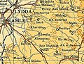
.jpg) 1870s map 1870s map .jpg) 1940s map 1940s map.jpg) modern map modern map .jpg) 1940s with modern overlay map 1940s with modern overlay mapA series of historical maps of the area around Barfiliya (click the buttons) | ||
Geopolitical entity Mandatory Palestine | | |
| Subdistrict | Ramle | |
| Date of depopulation | July 14, 1948[5] | |
| Area | ||
| • Total | 7,134 dunams (7.134 km2 or 2.754 sq mi) | |
| Population (1945) | ||
| • Total | 730[3][4] | |
| Cause(s) of depopulation | Military assault by Yishuv forces | |
| Current Localities | Military firing range | |
Barfiliya (
Barfiliya lay on a road between Jerusalem and Lydda that was built in Roman times. In the early Ottoman era, it was a small village of 44 inhabitants. By 1945, before the end of the Mandatory Palestine and the outbreak of 1948 Arab–Israeli War, its population had grown to 730. Depopulated on July 14, 1948, Barifiliya was subsequently destroyed.
Etymology
Barfīlyā /Barfīlya/ is a Greek place name, derived from Πορφυρίων/Πορφυρεών, which was the name of a mythological king, based on the word for “purple-fish”. The name is recorded in its Greek form in Crusader documents: Porphilia. By 1552, it was known in its modern Arabic form.[7]
Geography
Barfiliya was located in
History
Roman period
During the rule of the Roman Empire in Palestine, a road was built that connected Lydda to Jerusalem and passed through Barfiliya and other villages like Beit Liqya, Biddu and Beit Iksa.[10]
Crusader period
The

Ottoman period
Barfiliya, like the rest of Palestine, was ruled by the
In 1838, it was noted as a
An official Ottoman village list of about 1870 showed that "Berfilija" had 28 houses and a population of 175, though the population count included only men.[18][19] In the late 19th century, Barfiliya is described as a small hamlet, situated on a slope, 2,000 feet (610 m) above a valley. The villagers cultivated olives.[20]
During the
British Mandate
After the war's end, the
Still under Mandatory rule in the 1945 statistics, the village comprised a total area of 7,134 dunums, and the population was entirely Muslim.[4][3] A large number of inhabitants were employed in cereal farming.[24] However, some land was allocated to irrigation and plantation as well as the growing of olives.
|
Types of land use in dunams by Arabs in 1945:[24][25]
|
The land ownership of the village before occupation in dunams:[4]
|
17 dunams were classified as built-up public areas.[25]
-
 Barfiliya 1942 1:20,000
 -
 Barfiliya 1945 1:250,000
 -
 Palestinian villages depopulated in the area around Lydda and Ramla (coloured in green)


1948 war and aftermath
During the
Barfiliya itself was depopulated as a result of a military assault by Israeli forces on July 14, 1948.[5] It was captured by the 8th Armoured Brigade and by elements of the Kiryati Brigade along with other villages in the area north of the Latrun enclave.[28] On September 13, David Ben-Gurion requested the destruction of Barfiliya, among other Palestinian villages whose inhabitants fled or were expelled.[29] All 58 Palestinian villages in the al-Ramla district that came under Israeli control were depopulated in 1948, and those mentioned in Ben-Gurion's memorandum were either partially or totally destroyed.[30]
Archaeology
The village of Barfiliya stood on a large
References
- ^ Palestine Exploration Fund, 1838, p. 84
- ^ Palmer 1881, p. 287
- ^ a b Department of Statistics, 1945, p. 29
- ^ a b c d Government of Palestine, Department of Statistics. Village Statistics, April, 1945. Quoted in Hadawi, 1970, p. 66
- ^ a b Morris, 2004, p. xix, village #241. Also gives the cause for depopulation.
- ^ "Barfiliya". Palestine Remembered. Retrieved 2009-08-19.
- ^ Marom, Roy; Zadok, Ran (2023). "Early-Ottoman Palestinian Toponymy: A Linguistic Analysis of the (Micro-)Toponyms in Haseki Sultan's Endowment Deed (1552)". Zeitschrift des Deutschen Palästina-Vereins. 139 (2).
- ^ Saunders et al., 1881, p. 44.
- ^ Saunders et al., 1881, p. 235.
- ^ Pringle, 1998, p. 167
- ^ Pringle, 1993, p. 110
- ^ Röhricht, 1893, p. 41, no 165; cited in Pringle, 1993, p. 110
- ^ Röhricht, 1893, p. 129, no 490; cited in Pringle, 1993, p. 110
- ^ Hütteroth and Abdulfattah, 1977, p. 152. Quoted in Khalidi, p. 360.
- ^ Robinson and Smith, 1841, vol 3, Appendix 2, p. 121
- ^ Robinson and Smith, 1841, vol 3, p. 57
- ^ Guérin, 1868, p. 336
- ^ Socin, 1879, p. 145
- ^ Hartmann, 1883, p. 140 also noted 28 houses
- ^ Conder and Kitchener, 1883, SWP III, p. 15 Quoted in Khalidi, p.361
- ^ "El Burj, Palestine, 1 December 1917: Gullett's Account". Australian Light Horse Studies Centre. Archived from the original on 3 October 2009. Retrieved 2009-08-22.
- ^ Barron, 1923, Table VII, Sub-district of Ramleh, p. 22
- ^ Mills, 1932, p. 18
- ^ a b Government of Palestine, Department of Statistics. Village Statistics, April, 1945. Quoted in Hadawi, 1970, p. 114
- ^ a b Government of Palestine, Department of Statistics. Village Statistics, April, 1945. Quoted in Hadawi, 1970, p. 164
- ^ a b Benvenisti et al., 2007, pp. 70-71.
- ^ Shapira and Abel, 2008, p. 229.
- ^ Herzog and Gazit, 2004, p. 83.
- .
- ^ Sa'di and Abu-Lughod, 2007, p. 37
- ^ Proceedings of the Twenty-Second Congress of Orientalists, p. 595.
- ^ a b Gibson, Spring 1999, pp. 16-17.
Bibliography
- Barron, J. B., ed. (1923). Palestine: Report and General Abstracts of the Census of 1922. Government of Palestine.
- ISBN 978-3-540-68160-1.
- Conder, C.R.; Kitchener, H.H. (1883). The Survey of Western Palestine: Memoirs of the Topography, Orography, Hydrography, and Archaeology. Vol. 3. London: Committee of the Palestine Exploration Fund.
- Department of Statistics (1945). Village Statistics, April, 1945. Government of Palestine.
- Eshed, Vered (2018-03-13). "Modiʽin, Barfiliya" (130). Hadashot Arkheologiyot – Excavations and Surveys in Israel.
{{cite journal}}: Cite journal requires|journal=(help) - Gibson, S. (Spring 1999). "Landscape Archaeology and Salvage Excavations in Modi'in" (PDF). American Schools of Oriental Research Newsletter. 49 (1).
- Guérin, V. (1868). Description Géographique Historique et Archéologique de la Palestine (in French). Vol. 1: Judee, pt. 1. Paris: L'Imprimerie Nationale.
- Hadawi, S. (1970). Village Statistics of 1945: A Classification of Land and Area ownership in Palestine. Palestine Liberation Organization Research Center.
- Hartmann, M. (1883). "Die Ortschaftenliste des Liwa Jerusalem in dem türkischen Staatskalender für Syrien auf das Jahr 1288 der Flucht (1871)". Zeitschrift des Deutschen Palästina-Vereins. 6: 102–149.
- ISBN 978-1-85367-585-0.
- Hütteroth, Wolf-Dieter; Abdulfattah, Kamal (1977). Historical Geography of Palestine, Transjordan and Southern Syria in the Late 16th Century. Erlanger Geographische Arbeiten, Sonderband 5. Erlangen, Germany: Vorstand der Fränkischen Geographischen Gesellschaft. ISBN 3-920405-41-2.
- ISBN 0-88728-224-5.
- Mills, E., ed. (1932). Census of Palestine 1931. Population of Villages, Towns and Administrative Areas. Jerusalem: Government of Palestine.
- ISBN 978-0-521-00967-6.
- Palestine Exploration Fund (1838). Henry C. Stewardson (ed.). The Survey of Western Palestine. Printed for the Committee of the Palestine Exploration Fund by Harrison & Sons.
- Palmer, E.H. (1881). The Survey of Western Palestine: Arabic and English Name Lists Collected During the Survey by Lieutenants Conder and Kitchener, R. E. Transliterated and Explained by E.H. Palmer. Committee of the Palestine Exploration Fund.
- ISBN 0-521-39037-0.
- ISBN 0-521-39036-2.
- Proceedings of the Twenty-Second Congress of Orientalists. Brill Archive. 1957.
- Robinson, E.; Smith, E. (1841). Biblical Researches in Palestine, Mount Sinai and Arabia Petraea: A Journal of Travels in the year 1838. Vol. 3. Boston: Crocker & Brewster.
- Röhricht, R. (1893). (RRH) Regesta regni Hierosolymitani (MXCVII-MCCXCI) (in Latin). Berlin: Libraria Academica Wageriana.
- ISBN 978-0-231-13579-5.
- Saunders, Trelawny; Conder; Kitchener; Palestine Exploration Fund (1881). An Introduction to the Survey of Western Palestine: Its Waterways, Plains, & Highlands. New Burlington Street: Richard Bentley and Son.
- ISBN 978-0-8122-4028-3.
- Socin, A. (1879). "Alphabetisches Verzeichniss von Ortschaften des Paschalik Jerusalem". Zeitschrift des Deutschen Palästina-Vereins. 2: 135–163.
External links
- Welcome To Barfiliya
- Barfiliya, Zochrot
- Australian Light Horse Studies Centre
- Survey of Western Palestine, Map 17: IAA, Wikimedia commons
