
Huj, Gaza
Huj
هوج al-Hug, Hojj, Houg | ||
|---|---|---|
 Huj in 1948 | ||
| Etymology: Possibly named after the prophet Og[1] | ||
.jpg) 1870s map 1870s map .jpg) 1940s map 1940s map.jpg) modern map modern map .jpg) 1940s with modern overlay map 1940s with modern overlay mapA series of historical maps of the area around Huj, Gaza (click the buttons) | ||
Geopolitical entity Mandatory Palestine | | |
| Subdistrict | Gaza | |
| Date of depopulation | May 31, 1948[4] | |
| Area | ||
• Total | 21,988 dunams (22.9 km2 or 8.8 sq mi) | |
| Population (1945) | ||
• Total | 810[2][3] | |
| Cause(s) of depopulation | Expulsion by Yishuv forces | |
| Current Localities | Dorot[5] Havat Shikmim | |
Huj (
Situated in a hilly area on the northern edge of the
History
Architectural remains from the Iron Age, Persian and Hellenistic eras have been found here.[7]
Identified with the
Remains from the Umayyad era have also been found here.[7]
Ottoman era
The modern village of Huj was established sometime between 1818 and 1820 by
It was later resettled by fellahin from Gaza.[8]
In 1838,
In 1863 the French explorer
An Ottoman village list from about 1870 found that Huj had a population of 153, in 63 houses, though the population count included men, only.[12][13]
In 1883, the PEF's Survey of Western Palestine described it as a "small mud village on flat ground. It has a well some 200 feet deep. It is named from Nebi Huj".[14]
British mandate era
Huj witnessed battles between Ottoman and British forces known as the Charge at Huj in 1917. Following Great Britain's victory and the establishment of the British Mandate in Palestine, Huj expanded eastward and to the west. Water was provided by a 200-foot-deep (61 m) well, and by other wells in surrounding riverbeds. The inhabitants cultivated grains, apricots, figs, grapes, and almonds.[5]

In the 1922 census of Palestine, conducted by the British Mandate authorities, Huj had a population of 426 inhabitants, all Muslims,[15] increasing in the 1931 census to 618, still all Muslims, in 118 houses.[16]
In the 1945 statistics the population of Huj was counted with that of the nearby Jewish kibbutz Dorot, together they had a population of 810 Muslims and 230 Jews,[2] with a total of 21,988 dunams of land, according to an official land and population survey.[3] Of this, Arabs used 93 dunams for plantations and irrigable land, 16,236 for cereals,[17] while they had 34 dunams as built-up land.[18]
Huj was a village with traditions of friendship with Jews: in 1946, men from the Haganah, being pursued in a crackdown by the British army, were given sanctuary by its inhabitants. Only after the passage of the United Nations Partition Plan for Palestine in late November 1947 did relations sour and the mukhtar and his brother were shot on the charge that they were collaborators.[19][20]


-
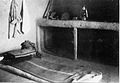 Domestic interior. Huj. 1948
 -
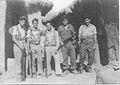 Yiftach Brigade in Huj. 1948
 -
 Collage of photos of Huj from Palmach archive. 1948
 -
 Huj, 1948. Photo from Palmach archive. See figure for scale.
 -
 Huj after the conquest. 1948


1948 war and aftermath
As the Egyptian army advanced from the south a decision was taken towards the end of May 1948 by the
"I hope that the HQ will pay attention to what you say, and will avoid such unjust and unjustified actions in the future, and will set right these things in so far as possible with respect to the past."[21]
In September 1948 former villagers of Huj, noting that the area around Huj was quiet, appealed to Israel to allow them back. Members of the Ministry of Minority Affairs Bechor-Shalom Sheetrit and Yaakov Shimoni wrote that the inhabitants deserved special treatment as they had been "loyal", and had not fled but were expelled. However, the Israeli defence authorities decided not to allow the villagers back.[20][22]
Havat Shikmim ("Sycamore Ranch") was built on Huj lands and was later purchased by Ariel Sharon in 1972.[23] According to Izzeldin Abuelaish the mosque of Huj has been serving as the pen for Sharon's Arabian thoroughbred horses.[24]
In 1992, the village site was described: "Only one dilapidated building remains, a concrete structure with rectangular doors and windows and a flat roof. Its former function is not clear; it now serves as a farm storehouse. One can also identify the remnants of a watering trough. Sycamore trees and cactuses grow on the eastern and western edges of the site. An Israeli sheep farm has also been established on the site."[5]
In 1998, refugees from Huj in Gaza numbered an estimated 5,770 people.[citation needed]
See also
- Depopulated Palestinian locations in Israel
References
- ^ Palmer, 1881, p. 367,377
- ^ a b Department of Statistics, 1945, p. 31
- ^ a b Government of Palestine, Department of Statistics. Village Statistics, April, 1945. Quoted in Hadawi, 1970, p. 45
- ^ Morris, 2004, p. XX, village #366. Also gives cause of depopulation.
- ^ a b c Khalidi, 1992, p. 103
- ^ a b Oga - (Huj) Studium Biblicum Franciscanum - Jerusalem. 2000-12-19.
- ^ a b c Oron, 2017, Horbat Hoga
- ^ Grossman, D. (1986). "Oscillations in the Rural Settlement of Samaria and Judaea in the Ottoman Period". in Shomron studies. Dar, S., Safrai, S., (eds). Tel Aviv: Hakibbutz Hameuchad Publishing House. p. 386
- ^ Robinson and Smith, 1841, vol 3, Appendix 2, p. 119
- ^ Robinson, 1841, vol 2, p. 385
- ^ Guérin, 1869, p. 292
- ^ Socin, 1879, p. 155
- ^ Hartmann, 1883, p. 133, also noted 63 houses
- ^ Conder and Kitchener, 1883, SWP III, p. 260
- ^ Barron, 1923, Table V, Sub-district of Gaza, p.8
- ^ Mills, 1932, p. 3.
- ^ Government of Palestine, Department of Statistics. Village Statistics, April, 1945. Quoted in Hadawi, 1970, p. 87
- ^ Government of Palestine, Department of Statistics. Village Statistics, April, 1945. Quoted in Hadawi, 1970, p. 137
- ^ Morris, 2004, p. 258
- ^ a b Robert Fisk, 2012, 'The suffering of Sderot: how its true inhabitants were wiped from Israel's maps and memories,' The Independent 12 November 2012.
- ^ Morris, 2004 pp. 306-7 n.786
- ^ Morris, 2004, pp. 332-3
- ^ Cook, Jonathan (December 2017). "In age of forest fires, Israel's law against Palestinian goats proves self-inflicted wound for Zionism". Jonathan Cook: the View from Nazareth. Retrieved 2019-06-13.
- ^ Kanaaneh, Hatim (2013-07-23). "Izzeldin Gandhi". A doctor in Galilee. Retrieved 2019-06-13.
Bibliography
- Barron, J.B., ed. (1923). Palestine: Report and General Abstracts of the Census of 1922. Government of Palestine.
- Conder, C.R.; Kitchener, H.H. (1883). The Survey of Western Palestine: Memoirs of the Topography, Orography, Hydrography, and Archaeology. Vol. 3. London: Committee of the Palestine Exploration Fund.
- Department of Statistics (1945). Village Statistics, April, 1945. Government of Palestine.
- Guérin, V. (1869). Description Géographique Historique et Archéologique de la Palestine (in French). Vol. 1: Judee, pt. 2. Paris: L'Imprimerie Nationale.
- Hadawi, S. (1970). Village Statistics of 1945: A Classification of Land and Area ownership in Palestine. Palestine Liberation Organization Research Center.
- Hartmann, M. (1883). "Die Ortschaftenliste des Liwa Jerusalem in dem türkischen Staatskalender für Syrien auf das Jahr 1288 der Flucht (1871)". Zeitschrift des Deutschen Palästina-Vereins. 6: 102–149.
- ISBN 0-88728-224-5.
- Mills, E., ed. (1932). Census of Palestine 1931. Population of Villages, Towns and Administrative Areas. Jerusalem: Government of Palestine.
- ISBN 978-0-521-00967-6.
- Oron, Maya (2017-12-03). "Horbat Hoga" (129). Hadashot Arkheologiyot – Excavations and Surveys in Israel.
{{cite journal}}: Cite journal requires|journal=(help) - Palmer, E.H. (1881). The Survey of Western Palestine: Arabic and English Name Lists Collected During the Survey by Lieutenants Conder and Kitchener, R. E. Transliterated and Explained by E.H. Palmer. Committee of the Palestine Exploration Fund.
- Robinson, E.; Smith, E. (1841). Biblical Researches in Palestine, Mount Sinai and Arabia Petraea: A Journal of Travels in the year 1838. Vol. 2. Boston: Crocker & Brewster.
- Robinson, E.; Smith, E. (1841). Biblical Researches in Palestine, Mount Sinai and Arabia Petraea: A Journal of Travels in the year 1838. Vol. 3. Boston: Crocker & Brewster.
- Socin, A. (1879). "Alphabetisches Verzeichniss von Ortschaften des Paschalik Jerusalem". Zeitschrift des Deutschen Palästina-Vereins. 2: 135–163.
External links
- Welcome to Huj, Palestineremembered.com
- Huj, Zochrot
- Survey of Western Palestine, Map 20: IAA, Wikimedia commons
- Huj from the Khalil Sakakini Cultural Center
