
Khulda
Khulda
خُلدة Khuldeh | ||
|---|---|---|
 The largest remaining house in Khulda | ||
| Etymology: "the perpetual"[1][2] | ||
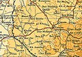
.jpg) 1870s map 1870s map .jpg) 1940s map 1940s map.jpg) modern map modern map .jpg) 1940s with modern overlay map 1940s with modern overlay mapA series of historical maps of the area around Khulda (click the buttons) | ||
Geopolitical entity Mandatory Palestine | | |
| Subdistrict | Ramle | |
| Date of depopulation | April 6, 1948[5] | |
| Area | ||
| • Total | 9,461 dunams (9.461 km2 or 3.653 sq mi) | |
| Population (1945) | ||
| • Total | 280[3][4] | |
| Cause(s) of depopulation | Military assault by Yishuv forces | |
| Current Localities | Mishmar David[6] | |
Khulda (
History
Khulda lay close to a highway connecting Gaza to the Ramla-Jerusalem highway.[7] During the Crusades, the village was known as Huldre. Situated 10 kilometers (6.2 mi) west-south-west of Imwas, prior to the 12th century CE, it lay on the border between the Greek archbishopric of Lydda and the ecclesiastical division of Emmaus, the latter of which was governed directly by archpriest of the Patriarch of Jerusalem.[8]
During the period of
Ottoman era
Khulda, like the rest of
When
In 1863 Victor Guérin noted a village with two hundred and fifty inhabitants, situated on a plateau.[14]
An official village list of about 1870 showed that the village had 28 houses and a population of 76, though the population count included only men.[15][16] Charles Simon Clermont-Ganneau visited Khulda in 1871, and was told by the inhabitants that the village used to be surrounded by a fortified wall, two gates of which were still supposed to be in situ. Clermont-Ganneau noted that this agreed well with what Mujir al-Din had written about the place.[17]
In 1882, the
British Mandate era
During British rule over
In the
The villagers maintained a
In the 1945 statistics, the population had grown to 280 Muslims,[3] with a total of 9,461 dunams of land.[4] Of this, a total of 8,994 dunums were used for cereals, 9 dunums were irrigated or used for orchards,[24] while 8 dunams were classified as built-up public areas.[25]
-
 Khulda 1942 1:20,000
 -
 Khulda 1945 1:250,000
 -
 Khulda 1948
 -
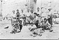 Members of Palmach posing amongst the ruins. Khulda April 1948


1948 and aftermath

Prior to the outbreak of the
Kibbutz
Andrew Petersen, an archaeologist specializing in
The second building stands north of first one, and is about half in size (6 m x 6 m). The roof is made in the same manner as the first house. The walls are made of boulders and rubble stone, joined together with mud mortar. A shallow niche in the south wall might be a mihrab. The walls are decorated with stencilled friezes of palm tree and palmettes in blue-green. A barely legible inscription above the door gives a 14th-century AH (late 19th-century CE) date.[27]
References
- ^ Conder, 2009, p. 268.
- ^ Palmer, 1881, p. 268
- ^ a b Department of Statistics, 1945, p. 29
- ^ a b c Government of Palestine, Department of Statistics. Village Statistics, April, 1945. Quoted in Hadawi, 1970, p. 67
- ^ Morris, 2004, p. xix, village #261. Also gives cause of depopulation.
- ^ Morris, 2004, p. xxi, settlement #37
- ^ a b c Khalidi, 1992, p. 389
- ^ Pringle, 1993, p. 53
- ^ Mujir al-Din, 1866, p.702 (Arabic text, published by Bulak, Cairo), cited in Clermont-Ganneau, 1896, II, p.251 -252
- ^ Moudjir ed-dyn, 1876, (French text) p.294
- ^ Hütteroth and Abdulfattah, 1977, p. 153. Quoted in Khalidi, 1992, p. 389
- ^ Robinson and Smith, 1841, vol 3, p. 21
- ^ Robinson and Smith, 1841, vol 3, Appendix 2, p. 120
- ^ Guérin, 1869, p. 32
- ^ Socin, 1879, p. 151
- ^ Hartmann, 1883, p. 140 also noted 28 houses
- ^ Clermont-Ganneau, 1896, II, p.467
- ^ Conder and Kitchener, 1882, SWP II, p.408. Quoted in Khalidi, 1992, p. 389
- ^ Sufian, 2007, p.324. N.B. In this text, Khulda is referred to as Khuldeh el-Islam, presumably to distinguish it from the newly created nearby Jewish settlement which was also named Khulde.
- ^ Sufian, 2007, p. 103
- ^ Barron, 1923, Table VII, Sub-district of Ramleh, p. 21
- ^ Mills, 1932, p. 21
- ^ El-Eini, 2006, p. 398.
- ^ Government of Palestine, Department of Statistics. Village Statistics, April, 1945. Quoted in Hadawi, 1970, p. 116
- ^ Government of Palestine, Department of Statistics. Village Statistics, April, 1945. Quoted in Hadawi, 1970, p. 166
- ^ a b Morris, 2004, p. 235
- ^ a b Petersen, 2001, p. 200
Bibliography
- Barron, J.B., ed. (1923). Palestine: Report and General Abstracts of the Census of 1922. Government of Palestine.
- Clermont-Ganneau, C.S. (1896). [ARP] Archaeological Researches in Palestine 1873-1874, translated from the French by J. McFarlane. Vol. 2. London: Palestine Exploration Fund.
- Conder, C.R.; Kitchener, H.H. (1882). The Survey of Western Palestine: Memoirs of the Topography, Orography, Hydrography, and Archaeology. Vol. 2. London: Committee of the Palestine Exploration Fund.
- ISBN 978-1-113-17340-9
- Department of Statistics (1945). Village Statistics, April, 1945. Government of Palestine.
- El-Eini, Roza (2006), Mandated landscape: British imperial rule in Palestine, 1929-1948 (Illustrated ed.), Routledge, ISBN 978-0-7146-5426-3
- Guérin, V. (1869). Description Géographique Historique et Archéologique de la Palestine (in French). Vol. 1: Judee, pt. 2. Paris: L'Imprimerie Nationale.
- Hadawi, S. (1970). Village Statistics of 1945: A Classification of Land and Area ownership in Palestine. Palestine Liberation Organization Research Center.
- Hartmann, M. (1883). "Die Ortschaftenliste des Liwa Jerusalem in dem türkischen Staatskalender für Syrien auf das Jahr 1288 der Flucht (1871)". Zeitschrift des Deutschen Palästina-Vereins. 6: 102–149.
- Hütteroth, Wolf-Dieter; Abdulfattah, Kamal (1977). Historical Geography of Palestine, Transjordan and Southern Syria in the Late 16th Century. Erlanger Geographische Arbeiten, Sonderband 5. Erlangen, Germany: Vorstand der Fränkischen Geographischen Gesellschaft. ISBN 3-920405-41-2.
- ISBN 0-88728-224-5.
- Mills, E., ed. (1932). Census of Palestine 1931. Population of Villages, Towns and Administrative Areas. Jerusalem: Government of Palestine.
- ISBN 978-0-521-00967-6.
- Moudjir ed-dyn (1876). Sauvaire (ed.). Histoire de Jérusalem et d'Hébron depuis Abraham jusqu'à la fin du XVe siècle de J.-C. : fragments de la Chronique de Moudjir-ed-dyn.
- Palmer, E.H. (1881). The Survey of Western Palestine: Arabic and English Name Lists Collected During the Survey by Lieutenants Conder and Kitchener, R. E. Transliterated and Explained by E.H. Palmer. Committee of the Palestine Exploration Fund.
- Petersen, Andrew (2001). A Gazetteer of Buildings in Muslim Palestine: Volume I (British Academy Monographs in Archaeology). ISBN 978-0-19-727011-0.
- ISBN 0-521-39036-2.
- Robinson, E.; Smith, E. (1841). Biblical Researches in Palestine, Mount Sinai and Arabia Petraea: A Journal of Travels in the year 1838. Vol. 3. Boston: Crocker & Brewster.
- Socin, A. (1879). "Alphabetisches Verzeichniss von Ortschaften des Paschalik Jerusalem". Zeitschrift des Deutschen Palästina-Vereins. 2: 135–163.
- Sufian, Sandra (1993). Healing the Land and the Nation: Malaria and the Zionist Project in Palestine, 1920-1947. Chicago: University of Chicago Press. ISBN 0-226-77935-1.
External links
- Welcome To Khulda
- Khulda, Zochrot
- Survey of Western Palestine, Map 16: IAA, Wikimedia commons
- Khulda, from the Khalil Sakakini Cultural Center
